How Level 4 Autonomous Vehicles Actually See the World in 2026
With robotaxis now completing hundreds of thousands of weekly rides, the secret to their safety lies in 'sensor fusion'—a complex integration of cameras, LiDAR, and radar.
By Factlen Editorial Team
- Autonomous System Developers
- The engineers and companies building the hardware and software for commercial robotaxis.
- Safety Data Analysts
- Independent researchers and government regulators tracking real-world crash statistics.
- Perception Engineers
- The specialists designing the AI architectures that process sensor data.
What's not represented
- · City Planners
- · Traditional Rideshare Drivers
Why this matters
As driverless vehicles expand into dozens of major cities, understanding how they perceive their surroundings demystifies the technology and helps passengers trust the safety mechanisms keeping them secure.
Key points
- Level 4 robotaxis are now completing over 400,000 commercial rides per week across 11 major US cities.
- Autonomous vehicles rely on 'sensor fusion'—combining cameras, LiDAR, and radar—to overcome the limitations of any single technology.
- Cameras provide color and texture, LiDAR maps precise 3D geometry, and radar tracks velocity through harsh weather.
- NHTSA data shows autonomous vehicles are solely at fault in just 4% of multi-vehicle accidents.
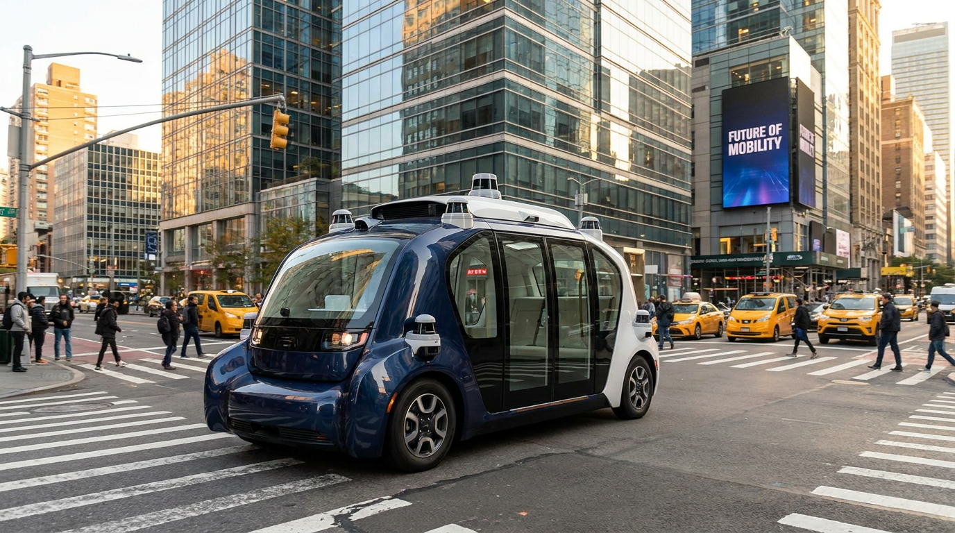
The reality of autonomous driving has quietly shifted from a futuristic promise to a daily utility. As of early 2026, Level 4 robotaxis are no longer confined to limited test tracks or safety-driver pilot programs. In cities ranging from San Francisco to Atlanta, fully driverless vehicles are completing over 400,000 commercial rides every single week. Passengers are routinely hailing these vehicles to commute to work, run errands, or get home safely after a night out, entirely without a human driver behind the wheel. This massive scale marks the moment when autonomous technology officially crossed the threshold into mainstream public transportation.[6][7]
The vehicles facilitating this transit revolution are also evolving beyond retrofitted consumer cars. Waymo’s newly deployed "Ojai" model, manufactured by Zeekr, represents the next generation of purpose-built robotaxis. The vehicle lacks a steering wheel and pedals entirely, featuring wide sliding doors and a low, flat floor designed specifically for accessibility and high-volume ride-hailing. But the true marvel of the Ojai isn't its spacious cabin—it is the invisible, highly sophisticated web of perception technology that allows a two-ton machine to navigate chaotic urban environments with superhuman precision.[6][7]
To achieve true Level 4 autonomy—a classification meaning the vehicle handles all driving tasks within a specific geographic area and the human is permanently removed from the control loop—a car cannot rely on a single type of sensor. Human drivers navigate using two eyes and a brain, which are easily compromised by fatigue, distraction, or poor visibility. Autonomous vehicles, by contrast, utilize a concept called "sensor fusion." This process combines dozens of distinct hardware inputs to create a flawless, 360-degree understanding of the world that never blinks and never loses focus.[3][4]

The foundation of this perception suite is the vehicle's camera network. Much like the human eye, high-resolution cameras capture the world in rich color and texture. They are the only sensors capable of reading the text on a speed limit sign, interpreting the exact color of a traffic light, or identifying temporary painted lane markings in a complex construction zone. By stitching together feeds from multiple wide-angle and long-range lenses, the vehicle maintains a continuous panoramic view of its surroundings.[1][3]
However, cameras have severe inherent limitations. Because they rely on ambient light, they struggle in blinding sun glare, heavy rain, or pitch darkness. Furthermore, cameras capture a flat, two-dimensional image and lack the native ability to judge precise distances. If a camera sees a large billboard depicting a pedestrian, the software might initially struggle to distinguish it from a real person standing in the middle of the road. Relying on cameras alone would leave the vehicle dangerously vulnerable to optical illusions and poor weather.[2][3]
This is where LiDAR—Light Detection and Ranging—steps in as the ultimate three-dimensional mapper. LiDAR units, often visible as the spinning pucks on the roof of a robotaxi, fire millions of invisible laser pulses per second in every direction. By measuring the exact fraction of a second it takes for each laser pulse to bounce off an object and return to the sensor, the system calculates distance with millimeter precision. This creates a dense, highly accurate "point cloud" of the surrounding environment.[1][2]
Modern 128-channel LiDAR systems are so powerful that they can detect the exact shape and distance of a child on a scooter at 100 meters away, regardless of whether it is high noon or the dead of night. Because LiDAR provides structural geometry rather than just a flat image, it acts as the spatial anchor for the vehicle. It ensures that the car's computer knows exactly where physical objects are located down to the centimeter, completely eliminating the depth-perception issues that plague camera-only systems.[3][4]

Because LiDAR provides structural geometry rather than just a flat image, it acts as the spatial anchor for the vehicle.
Yet, even LiDAR is not invincible. Because it relies on beams of light, LiDAR can be blinded by dense fog, heavy snow, or severe dust storms, which scatter the laser pulses before they can return to the sensor. To solve the weather problem and ensure total redundancy, Level 4 vehicles integrate a third critical technology: radar. Radar—Radio Detection and Ranging—emits radio waves that easily pierce through rain, fog, and dust, remaining highly effective in conditions that would blind both cameras and LiDAR.[2][3]
While radar lacks the high resolution needed to tell the difference between a parked car and a large dumpster, it excels at one critical task: measuring the exact velocity of moving objects. Using the Doppler effect, radar instantly calculates how fast the vehicle ahead is braking or whether a cross-traffic vehicle is accelerating. This provides a crucial safety net, allowing the robotaxi to track the speed of surrounding traffic even in zero-visibility conditions.[2][3]
Having 13 high-resolution cameras, four LiDAR units, and six radar sensors—the exact configuration of Waymo's 6th-generation hardware—creates a massive data bottleneck. A vehicle traveling 60 miles per hour moves nearly nine feet in just one-tenth of a second. If the car's computer hesitates for even a fraction of a moment while trying to process this mountain of sensor data, the results could be catastrophic. The hardware must be as fast as the sensors are accurate.[4][7]
To process this terabyte-scale data stream instantly, modern autonomous vehicles function as rolling supercomputers. They utilize advanced edge computing and cutting-edge AI architectures known as "Spatiotemporal Transformers." Rather than processing the camera feed, the LiDAR point cloud, and the radar data in isolation, these neural networks ingest the raw data from all of the sensors simultaneously. The processing happens locally within the vehicle, ensuring that a dropped cellular connection never compromises the car's ability to drive safely.[1][5]

The AI projects this massive, fused data stream into a unified "Bird's-Eye-View" (BEV) coordinate map centered on the vehicle. This early-fusion approach allows the car's brain to cross-verify inputs in real-time. If a camera is blinded by the setting sun, the LiDAR still confirms the road is clear. If heavy fog obscures the LiDAR's lasers, the radar still tracks the braking car ahead. The weaknesses of one sensor are instantly covered by the strengths of the others.[3][5]
Instead of just recognizing specific, pre-programmed objects, the most advanced 2026 systems utilize "Occupancy Networks." These networks don't just ask the AI to identify whether an object is a car, a bicycle, or a pedestrian. Instead, they ask a much safer question: "Is this specific block of 3D space physically occupied by matter?" This ensures the vehicle will brake for a fallen refrigerator, an overturned truck, or an unmapped sinkhole, even if the AI has never been trained to recognize those specific shapes.[5]
The empirical results of this redundant, multi-sensor approach are becoming undeniably clear in the 2026 safety data. According to an extensive analysis of National Highway Traffic Safety Administration (NHTSA) crash reports from 2021 through 2025, autonomous vehicles are proving to be exceptionally safe road users. In multi-vehicle accidents involving a robotaxi and human drivers, the autonomous system was found to be solely at fault in only 4% of the incidents. Furthermore, there have been zero human fatalities caused by an autonomous vehicle during that multi-year tracking period, underscoring the life-saving potential of removing human error from the driving equation.[8]

The vast majority of incidents involving Level 4 robotaxis are low-speed collisions where the autonomous vehicle is rear-ended by a distracted human driver. While the technology is not entirely infallible—and edge cases involving unpredictable human behavior still pose ongoing engineering challenges—the fusion of cameras, LiDAR, and radar has succeeded. It has successfully transitioned autonomous driving from a fragile, experimental prototype into a robust, daily utility that is actively making city streets safer for hundreds of thousands of riders.[6][8]
How we got here
August 2019
First autonomous vehicle incidents reported to the NHTSA under early testing programs.
January 2026
Waymo unveils the 'Ojai', a custom-built electric robotaxi with no steering wheel or pedals.
April 2026
Commercial Level 4 robotaxi services surpass 400,000 weekly rides across 11 major US cities.
May 2026
The 6th-generation autonomous driving systems open to the public, expanding operations into snowier climates.
Viewpoints in depth
Autonomous System Developers
The engineers and companies building the hardware and software for robotaxis.
This camp emphasizes that human drivers are fundamentally flawed—prone to distraction, fatigue, and poor visibility. By utilizing a redundant suite of cameras, LiDAR, and radar, developers argue that autonomous systems have a superhuman perception of the road. They point to the massive reduction in serious injury crashes as proof that scaling Level 4 technology is a moral imperative for public safety.
Safety Data Analysts
Independent researchers and government regulators tracking real-world crash statistics.
Analysts focus strictly on the empirical data rather than theoretical capabilities. They acknowledge that while robotaxis are involved in accidents, the vast majority are low-speed incidents where a human driver rear-ends the autonomous vehicle. However, they caution that edge cases—such as unpredictable pedestrian behavior or complex construction zones—still require rigorous monitoring as these fleets expand into denser, more chaotic cities.
Perception Engineers
The specialists designing the AI architectures that process sensor data.
For perception engineers, the challenge is no longer just gathering data, but processing it instantly. They argue that the shift to "Bird's-Eye-View" (BEV) fusion and Occupancy Networks is the true breakthrough of 2026. By training AI to recognize occupied space rather than just specific object classes, they believe the systems are finally robust enough to handle the bizarre, unmapped anomalies that occur on real-world roads.
What we don't know
- How quickly regulatory bodies will approve the removal of steering wheels for commercial fleets nationwide.
- The long-term maintenance costs of keeping highly sensitive LiDAR and radar arrays calibrated after years of pothole impacts.
- Whether the massive data processing requirements of Level 4 autonomy can be miniaturized enough to become affordable for personal, privately-owned vehicles.
Key terms
- Sensor Fusion
- The process of combining data from multiple different sensors (like cameras and radar) to create a single, highly reliable understanding of the environment.
- LiDAR
- Light Detection and Ranging; a sensor that uses rapid laser pulses to measure distances and create a precise 3D map of the surroundings.
- Radar
- Radio Detection and Ranging; a sensor that uses radio waves to detect objects and measure their exact speed, highly effective in bad weather.
- Bird's-Eye-View (BEV) Mapping
- An AI technique that projects all raw sensor data into a unified, top-down 3D coordinate map centered on the vehicle.
- Occupancy Network
- An AI safety system that predicts whether a specific block of 3D space is physically occupied by matter, rather than just trying to identify what the object is.
Frequently asked
Do Level 4 autonomous vehicles have human backup drivers?
No. By definition, Level 4 autonomy means the vehicle handles all driving tasks within its designated area, and the human is permanently removed from the control loop.
How do self-driving cars see in the dark or in bad weather?
While cameras struggle in the dark, LiDAR uses its own laser light to see perfectly at night. In heavy fog or snow, the vehicle relies on radar, which uses radio waves that pierce through weather obstructions.
What happens if a sensor fails while the car is moving?
Level 4 vehicles are built with deep redundancy. If a camera is blinded or fails, the overlapping LiDAR and radar sensors immediately compensate to safely navigate or pull the vehicle over.
Are robotaxis actually safer than human drivers?
Current data strongly suggests they are. NHTSA crash data from 2021 to 2025 shows that in accidents involving both an autonomous vehicle and a human driver, the autonomous system was solely at fault only 4% of the time.
Sources
Source coverage
9 outlets
3 viewpoints surfaced


[1]NVIDIAAutonomous System Developers
How Autonomous Vehicles See the World Through Sensor Fusion
Read on NVIDIA →[2]MediumPerception Engineers
Sensing the Environment: How Autonomous Vehicles Perceive the World
Read on Medium →[3]PatSnapPerception Engineers
LiDAR, Radar, and Camera Sensor Fusion for Level 4 Autonomy
Read on PatSnap →[4]LiDAR SeekPerception Engineers
The Perception Gap: Why Standard LiDAR Fails at High Speeds
Read on LiDAR Seek →[5]UDHYPerception Engineers
BEV Sensor Fusion With Spatiotemporal Transformers: A Production AV Guide
Read on UDHY →[6]Car and DriverAutonomous System Developers
Waymo and Zoox Are No Longer Dipping Their Toes in the AV Pool
Read on Car and Driver →[7]Built InAutonomous System Developers
Waymo's Robotaxi Expansion: What to Know About the Ojai Vehicle
Read on Built In →[8]Trial ProvenSafety Data Analysts
Autonomous Vehicle Accident Statistics: Who Is At Fault?
Read on Trial Proven →[9]Factlen Editorial TeamAutonomous System Developers
Synthesis by Factlen editorial team
Read on Factlen Editorial Team →
Every angle. Every day.
Get automotive stories with full source coverage and perspective breakdowns delivered to your inbox.