How AI and Drones Are Accelerating Humanitarian Demining
Machine learning algorithms are analyzing millions of drone images to detect unexploded ordnance, cutting survey times by 90% and keeping human deminers out of harm's way.
By Factlen Editorial Team
- Humanitarian Demining Organizations
- Focused on scaling clearance efforts to return land to civilians safely.
- Defense Technology Developers
- Focused on refining algorithmic accuracy and processing massive datasets at the edge.
- Academic & Scientific Researchers
- Focused on methodological rigor, transparent uncertainty, and overcoming sensor limitations.
What's not represented
- · Local Farmers & Agricultural Workers
- · Civilian Populations in Post-Conflict Zones
Why this matters
Traditional landmine clearance is so slow that contaminated agricultural land can remain unusable for generations. By automating the discovery phase, AI is drastically accelerating the return of safe land to civilians and farmers while preventing thousands of accidental casualties.
Key points
- Over 100 million landmines remain buried globally, rendering vast agricultural areas unusable.
- Humanitarian groups are using drones and AI to remotely map explosive hazards without risking human lives.
- Cloud-based AI processing has cut the time required for non-technical surveys by up to 90 percent.
- Logic-guided AI frameworks are significantly reducing the false positives caused by harmless scrap metal.
- Optical AI still struggles to identify deeply buried mines or objects hidden under dense forest canopies.
- Future technologies will pair AI with magnetic resonance to detect the molecular signature of explosives underground.
The global scale of explosive remnants of war presents a humanitarian and logistical challenge that traditional methods are struggling to meet. Worldwide, an estimated 100 million landmines and unexploded munitions remain hidden in the ground, rendering vast tracts of agricultural land unusable and threatening civilian populations decades after conflicts end. In Ukraine alone, government and humanitarian agencies estimate that over 174,000 square kilometers of land—an area larger than Greece—may be contaminated with explosive hazards. Using conventional manual clearance methods, which rely heavily on humans walking grid lines with handheld metal detectors, experts project it would take over a century and billions of dollars to fully clear the country. This glacial pace leaves displaced families in limbo and severely impacts global food supplies by idling some of the world's most productive farmland.[1][5]
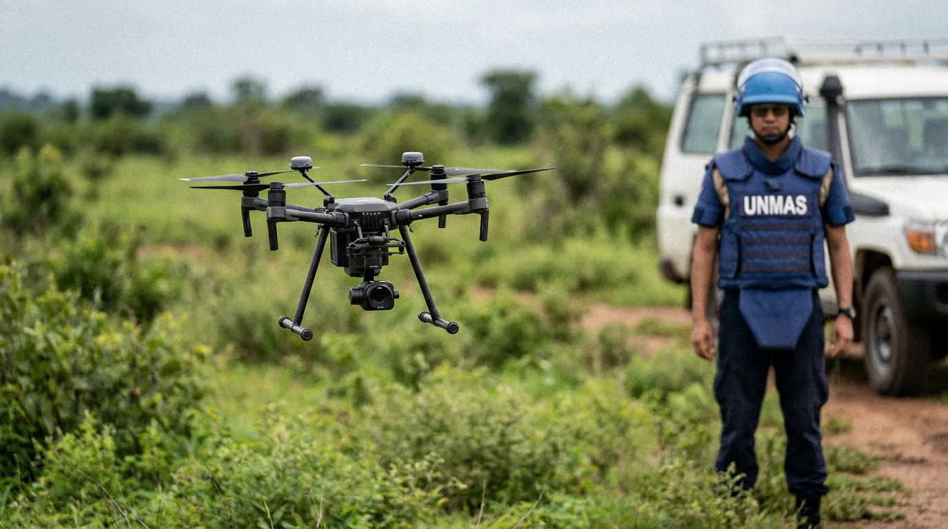
To bridge this massive capability gap, the humanitarian demining sector is undergoing a rapid technological paradigm shift, replacing analog surveys with artificial intelligence and autonomous drones. Instead of sending human operators into suspected minefields blind, organizations are deploying commercial off-the-shelf drones equipped with high-resolution optical and thermal sensors. These drones fly pre-programmed grid patterns over contested areas, capturing thousands of images without ever putting a human life at risk. The resulting data is then fed into advanced machine learning algorithms trained specifically to recognize the visual signatures of surface-laid mines, tripwires, and unexploded ordnance (UXO). This remote-sensing approach fundamentally inverts the traditional demining workflow, allowing teams to mathematically rule out safe land from a distance.[1][6]
The primary claim driving this technological adoption is that AI drastically accelerates the "non-technical survey" phase of demining, saving both time and resources. The evidence for this acceleration is robust and highly quantifiable. In recent field operations, Norwegian People's Aid partnered with Amazon Web Services and defense tech firm Safe Pro Group to process aerial imagery using cloud-based AI. The results demonstrated a 90 percent reduction in the time required to analyze survey images compared to human analysts. Furthermore, the automated platform cut overall survey analysis costs by an estimated 80 percent. By processing each high-resolution image in just one-fifth of a second, the AI allows demining organizations to map vast agricultural sectors in days rather than months.[5]

The mechanics of these AI systems rely on massive, crowd-sourced datasets gathered from active conflict zones. Algorithms are trained on millions of annotated images, learning to detect subtle geometric anomalies, unnatural color variations, and the specific shapes of over 150 types of explosive threats. When a drone completes its flight, the software instantly analyzes the raw data and generates highly accurate 2D and 3D maps with bounding boxes highlighting suspected hazards. This rapid turnaround is critical for field commanders who need to prioritize which areas require immediate physical clearance to allow utility workers to repair infrastructure or farmers to plant crops.[5][6]
A secondary, yet equally vital claim is that machine learning can successfully identify proxy indicators when the ordnance itself is too small or obscured to be seen directly. The evidence for this comes from the NASA Harvest consortium, which developed automated methods to detect artillery craters using very high-resolution satellite imagery. Because artillery shells have a known failure rate, clusters of craters serve as a highly reliable proxy for the presence of unexploded shells. The researchers' best-performing model parsed massive swaths of eastern Ukraine and successfully identified 22,000 distinct artillery craters. By mapping these proxy indicators, demining teams can pinpoint high-probability UXO zones without needing to spot the individual, partially buried munitions.[3]
The sheer volume of data generated by modern aerial surveys makes artificial intelligence an absolute necessity rather than a mere luxury. The HALO Trust, the world's largest humanitarian mine clearance organization, has flown hundreds of drone missions over contaminated regions, accumulating over 11 terabytes of raw visual data. Manually reviewing this volume of imagery—equivalent to tens of thousands of encyclopedias—would require an army of human analysts and introduce severe fatigue-based errors. AI acts as a critical force multiplier for the organization's 11,000 global staff, seamlessly processing the data offline in remote field locations and syncing to the cloud when bandwidth permits.[1]

The sheer volume of data generated by modern aerial surveys makes artificial intelligence an absolute necessity rather than a mere luxury.
A third major claim supporting the deployment of AI is its ability to significantly reduce false positives compared to traditional clearance methods. For decades, the standard tool for a deminer has been the handheld metal detector. However, in post-conflict environments, the ground is often heavily saturated with harmless scrap metal, bullet casings, and agricultural debris. Conventional detectors cannot differentiate between a lethal landmine and a rusted tin can, forcing deminers to stop, drop to their knees, and painstakingly excavate every single metallic ping. This high false-positive rate is the primary bottleneck in manual clearance operations, making the process inherently inefficient.[2][4]
Evidence from the academic computer vision community demonstrates that AI can overcome this limitation by reasoning about physical context. Researchers recently published the DEFUSAL framework, a logic-guided architecture designed specifically for real-world UXO identification. Unlike basic image classifiers that simply match pixel patterns, this framework bridges raw perception with domain knowledge, allowing the AI to reason about the physical reality of the object it is viewing. In empirical testing, this logic-guided approach surpassed traditional zero-shot models, improving the F1-score—a metric balancing precision and recall—by 32.7 percent. This proves that AI can reliably filter out harmless debris while maintaining strict safety margins for rare ordnance types.[4]
The real-world efficacy of these models is now being proven at an unprecedented scale. Safe Pro Group recently announced that its proprietary AI algorithms surpassed 50,000 confirmed landmine and UXO detections in active clearance zones. To achieve this milestone, the system analyzed over 2.75 million drone images covering roughly 35,000 acres of contaminated land. This massive, battle-tested dataset creates a continuous feedback loop; every confirmed detection or corrected false positive is fed back into the neural network, making the algorithm progressively smarter and more resilient to diverse environmental conditions.[6]

Despite these remarkable advancements, the evidence pack carries transparent uncertainty, particularly regarding the limitations of optical AI. The most significant weakness in current drone-based detection is its inability to reliably identify buried landmines. If an explosive device was deployed by hand beneath the soil and the surface vegetation has regrown, standard optical and thermal cameras will simply not see it. Consequently, AI is currently most effective against surface-laid anti-tank mines, recently scattered cluster munitions, and tripwire-activated devices, leaving a critical gap in detecting older, subterranean threats.[2]
Furthermore, AI systems still struggle in "high-metal areas" where intense kinetic warfare has taken place. In zones subjected to heavy artillery barrages, the earth is saturated with thousands of jagged metal shrapnel fragments. While advanced algorithms are better than basic metal detectors at filtering out obvious scrap, the sheer density of twisted metal can overwhelm optical sensors, especially when shrapnel visually mimics the casing of a damaged munition. In these highly complex environments, the uncertainty in detection remains high, and AI predictions must be treated with extreme caution.[2]
Dense vegetation and forest canopies present another unresolved challenge for aerial AI detection. Drones cannot easily peer through thick foliage to spot small anti-personnel mines hidden in the underbrush. Because of these physical limitations, humanitarian organizations emphasize that AI is a survey tool, not a complete clearance solution. While algorithms can shrink a suspected hazardous area from the size of a football pitch down to the six-yard box, highly trained human deminers, armored mechanical rollers, and explosive-sniffing dogs are still absolutely required to physically neutralize the threats and guarantee the land is safe for civilian use.[2][7]

To address these blind spots, the next frontier of demining technology involves multi-modal sensor fusion. Researchers are moving beyond standard cameras, partnering with tech firms to develop handheld and drone-mounted magnetic resonance detectors. Unlike conventional sensors that look for metal or visual shapes, these new devices are tuned to detect the specific molecular identity of explosive compounds buried in the earth. By combining the rapid wide-area scanning of optical AI with the deep-penetrating chemical verification of magnetic resonance, demining teams hope to bypass the shrapnel problem entirely and detect low-metal mines hidden deep underground.[1]
The integration of artificial intelligence into humanitarian demining represents one of the most consequential applications of machine learning for public safety. While the technology does not completely remove the inherent dangers of the profession, it fundamentally changes the risk calculus. By automating the discovery phase and providing high-fidelity threat maps, AI ensures that human deminers only step into harm's way when absolutely necessary. As these algorithms grow more sophisticated and sensor payloads become more advanced, the global community moves significantly closer to the goal of eradicating explosive remnants of war and returning stolen land to the people who depend on it.[7]
How we got here
1988
The HALO Trust is founded in Afghanistan to pioneer humanitarian landmine clearance.
2022
The conflict in Ukraine creates one of the largest UXO contamination crises in modern history.
Fall 2023
Early AI models achieve 90% accuracy in predicting probable landmine areas in test projects.
Mid 2024
The HALO Trust partners with AWS to process 11 terabytes of drone imagery using machine learning.
May 2026
Safe Pro Group's AI models surpass 50,000 confirmed landmine and UXO detections in active clearance zones.
Viewpoints in depth
Humanitarian Demining Organizations
Focused on scaling clearance efforts to return land to civilians safely.
Groups like The HALO Trust and Norwegian People's Aid view AI as a critical force multiplier. Their primary bottleneck is the "non-technical survey"—the slow process of determining if a field is actually mined before sending in humans. By using drones to rule out empty land, they can concentrate their limited human resources on confirmed threat zones, drastically reducing civilian casualties and accelerating agricultural recovery.
Defense Technology Developers
Focused on refining algorithmic accuracy and processing massive datasets at the edge.
Companies building these systems emphasize the sheer computational challenge of the task. Processing terabytes of high-resolution drone video in environments with zero internet connectivity requires highly optimized edge-computing hardware. Their goal is to continuously train models on diverse terrains to lower the false-negative rate to absolute zero, ensuring no lethal object is ever misclassified as a rock or debris.
Academic & Scientific Researchers
Focused on methodological rigor, transparent uncertainty, and overcoming sensor limitations.
The scientific community is highly focused on the "false positive" problem caused by battlefield shrapnel. Researchers are developing logic-guided frameworks that force AI to reason about physical reality rather than just matching pixels. They are also pioneering multi-modal approaches, combining optical drone imagery with ground-penetrating radar and magnetic resonance to detect the molecular signature of explosives, bypassing the limitations of standard cameras.
What we don't know
- Whether multi-modal sensors like magnetic resonance can be miniaturized enough to fly efficiently on lightweight commercial drones.
- How quickly international regulatory bodies will update official mine-action standards to fully certify AI-cleared land for civilian use.
- The exact false-negative rate of these algorithms when deployed in entirely new biomes or jungle environments not represented in their training data.
Key terms
- Unexploded Ordnance (UXO)
- Explosive weapons such as bombs, shells, and grenades that failed to detonate as intended and remain a hazard.
- Non-Technical Survey (NTS)
- The initial phase of demining where teams gather data to identify suspected hazardous areas without physically entering them.
- False Positive
- In demining, when a sensor incorrectly identifies harmless scrap metal or debris as an explosive threat.
- F1-Score
- A statistical measure of a machine learning model's accuracy that balances precision (avoiding false positives) and recall (avoiding false negatives).
Frequently asked
Can AI detect landmines that are buried underground?
Standard optical AI models struggle with buried mines. However, researchers are combining AI with ground-penetrating radar and magnetic resonance sensors to detect the molecular signatures of explosives beneath the surface.
Does AI replace human deminers?
No. AI is used for the 'non-technical survey' phase to map threats and rule out safe areas. Highly trained human deminers and specialized machines are still required to physically neutralize the explosives.
How accurate are these machine learning models?
Accuracy is improving rapidly. Recent logic-guided AI frameworks have improved identification scores by over 30%, and commercial models have successfully confirmed over 50,000 explosive hazards in real-world deployments.
Sources
Source coverage
7 outlets
3 viewpoints surfaced


[1]The HALO TrustHumanitarian Demining Organizations
Artificial Intelligence to Help Accelerate Landmine Clearance
Read on The HALO Trust →[2]United Nations Mine Action ServiceHumanitarian Demining Organizations
Deminers race to keep up with military technology
Read on United Nations Mine Action Service →[3]NASA HarvestAcademic & Scientific Researchers
Locating Unexploded Ordnance in Ukraine Using Satellite Imagery
Read on NASA Harvest →[4]Computer Vision FoundationAcademic & Scientific Researchers
Look, Reason, Defuse: Bridging Perception and Domain Knowledge for Real-World Unexploded Ordnance Identification
Read on Computer Vision Foundation →[5]Amazon Web ServicesHumanitarian Demining Organizations
Norwegian People's Aid Cuts Ukraine Landmine Survey Times by 90% Using AWS and Safe Pro AI Image Analysis
Read on Amazon Web Services →[6]Safe Pro GroupDefense Technology Developers
Safe Pro Celebrates 50,000th AI-Powered Landmine Detection
Read on Safe Pro Group →[7]Factlen Editorial Team
Synthesis by Factlen editorial team
Read on Factlen Editorial Team →
Every angle. Every day.
Get defense security stories with full source coverage and perspective breakdowns delivered to your inbox.