How AI and Drone Swarms Are Solving the 1,000-Year Landmine Crisis
Humanitarian organizations and defense startups are deploying deep learning algorithms and multi-modal drones to map minefields in hours rather than days, drastically accelerating the clearance of explosive remnants of war.
By Factlen Editorial Team
- Humanitarian Demining Organizations
- Focuses on scaling clearance operations safely to return agricultural land and infrastructure to civilian populations.
- Defense Tech Innovators
- Prioritizes rapid algorithmic development, sensor fusion, and the deployment of autonomous systems in active conflict zones.
- AI & Computer Vision Researchers
- Concentrates on improving the mathematical accuracy, precision, and edge-computing capabilities of foundation models.
What's not represented
- · Local farmers whose land is contaminated
- · Environmental scientists studying the ecological impact of demining
Why this matters
Traditional landmine clearance is so slow that it would take centuries to rid the world of existing explosives. The integration of AI and drone swarms is turning a 1,000-year humanitarian crisis into a solvable generational challenge, accelerating the return of safe agricultural land to millions of people.
Key points
- Over 110 million unexploded landmines globally cost thousands of lives annually and cripple post-conflict economies.
- Traditional manual clearance using metal detectors is dangerous, expensive, and overwhelmed by false positives from scrap metal.
- Humanitarian groups are now using drones equipped with optical, thermal, and radar sensors to map minefields from the air.
- Deep learning algorithms process this aerial data to identify the specific visual and thermal signatures of buried explosives.
- AI analysis reduces the time needed to map a minefield from several days to a matter of hours.
- While AI drastically narrows the search grid, human sappers or robotic excavators are still required for final neutralization.
The scale of the global landmine crisis is a mathematical nightmare. Across more than 60 countries, an estimated 110 million unexploded landmines lie dormant beneath the soil, indiscriminately threatening civilian lives and crippling agricultural economies long after conflicts have ended. The economics of this contamination are brutally asymmetrical: a landmine costs between $3 and $30 to manufacture and deploy, but safely locating and removing it costs between $300 and $1,000. In Ukraine alone, which has recently become the most heavily mined country on Earth, an estimated 170,000 square kilometers—roughly a third of its sovereign territory—is contaminated with explosive remnants of war. Global security analysts estimate that relying solely on traditional manual clearance methods, it would take 757 years and tens of billions of dollars to fully demine the nation.[1][5]
For decades, the methodology of humanitarian demining has remained agonizingly static and inherently perilous. The standard approach relies heavily on human sappers slowly walking through suspected hazardous areas with handheld metal detectors, gently prodding the earth centimeter by centimeter. This traditional method is not only dangerous but highly inefficient due to the overwhelming prevalence of false positives. In war-torn regions, the soil is saturated with shrapnel, bullet casings, and harmless scrap metal. A sapper might excavate hundreds of metallic signals before uncovering a single actual explosive device. This painstaking process means that clearing a single agricultural field can take weeks, delaying the return of displaced civilians and preventing farmers from planting vital crops.[1][2]
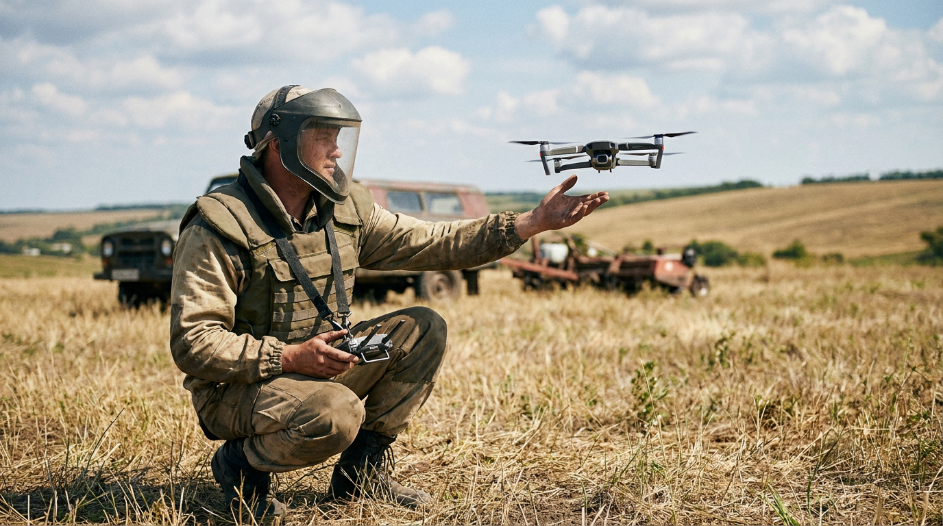
A profound paradigm shift is now underway, driven by the convergence of commercial unmanned aerial vehicles (UAVs) and advanced machine learning algorithms. Humanitarian organizations and defense technology startups are moving toward an "imagery-first" approach, utilizing drone swarms to conduct non-technical surveys from the sky. Rather than sending humans blindly into a minefield, operators fly drones equipped with multi-modal sensor payloads over suspected areas to map the terrain in high resolution. This aerial data is then fed into deep learning models trained specifically to recognize the visual, thermal, and magnetic signatures of various explosive devices. The result is a highly accurate digital risk map that tells clearance teams exactly where to look, transforming a blind search into a targeted surgical operation.[2][6]
The hardware enabling this breakthrough relies on a sophisticated fusion of sensors, as no single camera can detect every type of threat. Standard RGB optical cameras capture high-resolution visual data, allowing algorithms to spot surface-laid scatterable mines or the subtle craters left by anti-tank detonations. However, because many mines are buried or obscured by vegetation, drones are increasingly equipped with thermal infrared imaging. Landmines—whether encased in metal or plastic—absorb and dissipate solar heat at different rates than the surrounding soil. During specific thermal crossover periods, such as sunrise or sunset, these temperature differentials become visible to infrared sensors, effectively outlining the buried explosives. For deeper threats, developers are integrating lightweight magnetometers and Ground Penetrating Radar (GPR) to image the subsurface without disturbing the earth.[4][6]

The utility of this technology is particularly evident when dealing with surface-laid scatterable munitions, such as POM-2 and POM-3 mines. These explosives are typically deployed remotely, scattering randomly over vast areas and creating immediate, unpredictable hazards. Because of their small size and irregular deployment patterns, manual mapping is incredibly dangerous and slow. However, deep learning models excel at identifying the distinct shapes of these specific munitions from aerial imagery. In recent trials evaluating computer vision foundation models on drone flyby datasets, researchers achieved highly accurate detection rates for these specific surface mines, turning one of the most difficult clearance tasks into a rapidly solvable computational problem.[7]
The true engine of this revolution, however, lies in the software. Processing the massive volume of data generated by multi-modal drone flights is impossible for human analysts to do at scale. To solve this, researchers are deploying Convolutional Neural Networks (CNNs)—a class of deep learning algorithms highly effective at image recognition. Models based on architectures like YOLO (You Only Look Once) and MobileNetV3 are trained on vast datasets containing hundreds of thousands of annotated images of landmines in various environments. These neural networks learn to identify the geometric shapes of specific munitions, the thermal halos of buried explosives, and the contextual clues of disturbed earth, isolating threats with a speed and consistency that human eyes cannot match.[4][7]
The true engine of this revolution, however, lies in the software.
The empirical evidence supporting these AI models is highly encouraging, with recent academic benchmarks demonstrating significant leaps in detection accuracy. In a comprehensive study published by the IEEE, researchers utilized a MobileNetV3-Large architecture to analyze 2,700 thermographic images captured by a drone. Through rigorous data pre-processing and augmentation, the lightweight model achieved a remarkable test accuracy of 96.14% in identifying buried landmines across different terrains. Similarly, computer vision researchers evaluating surface mine detection using the YOLOF foundation model reported mean Average Precision (mAP) scores of 0.89 on drone flyby datasets. These metrics indicate that machine learning models are not just theoretical concepts, but highly capable tools ready for real-world deployment.[4][7]
Beyond controlled academic environments, these systems are already proving their worth in active clearance operations. The HALO Trust, the world's largest humanitarian landmine clearance organization, recently partnered with Amazon Web Services to process drone imagery using cloud-based machine learning tools. Historically, an analyst manually reviewing thousands of aerial photographs to map a single average-sized minefield would require three to five days of continuous work. By routing that same imagery through AI models hosted on AWS infrastructure, HALO has reduced the analysis time to a mere matter of hours. This exponential increase in processing speed allows organizations to rapidly prioritize which fields pose the greatest immediate risk to returning civilian populations.[2]

The urgency of the crisis in Ukraine has transformed the country into a rapid innovation laboratory for demining technology. In Kyiv, government-backed hackathons like the AI Data Jam have brought together dozens of IT engineers and data analysts to train algorithms on real field images provided by humanitarian groups. Winning models, such as those developed by the "Mine Watch AI" team, are being actively funded by the United Nations Development Programme (UNDP) to transition from prototype to operational software. Concurrently, Ukrainian defense tech startups like UADamage have developed autonomous drone systems capable of surveying up to 10,000 square meters of mined territory in a single day, automatically generating detailed hazard maps without human intervention.[3][5][6]
Commercial scaling is further accelerating the deployment of these life-saving tools. Startups like Dropla Tech are building proprietary datasets containing over a million images of explosive ordnance, achieving real-world detection accuracies of around 80% across diverse environments. Recognizing that high-speed internet is rarely available in remote or war-torn regions, developers are pushing AI inference directly to the edge. Portable AI units can now be attached directly to drone controllers, allowing soldiers and sappers to process imagery and detect mines on supply routes in real-time, completely offline. This edge-computing capability is critical for ensuring that the technology remains viable in the austere environments where it is needed most.[1]
The application of machine learning extends beyond direct image recognition; it is also being used for predictive risk mapping before drones even take flight. The RELand (Risk Estimation of Landmines) system, co-designed with the United Nations Mine Action Service, utilizes historical conflict data, geographic features, and socio-demographic variables to predict the likelihood of mine contamination in un-surveyed areas. By treating mine placement not as random, but as a product of strategic war logic, the algorithm identifies cohesive hazard clusters. In field tests across Colombia and Afghanistan, this predictive modeling successfully guided teams to previously unknown minefields, effectively cutting the time spent on false alarms and empty surveys in half.[8]
Despite the rapid technological advancements, transparent uncertainty remains a critical component of AI-assisted demining. The models are highly proficient, but they are not infallible. Dense vegetation, heavy mud, and deep snow can severely occlude optical and thermal sensors, rendering the AI blind to underlying threats. Furthermore, while algorithms have vastly improved at distinguishing between a landmine and a rock, the "scrap metal" problem persists. Highly fragmented battlefields littered with unexploded ordnance and metallic debris still generate false positives that require human verification. Developers openly acknowledge that the complexity and variability of natural terrain make achieving 100% autonomous detection an elusive, and perhaps impossible, goal.[1][2]

Because of these inherent limitations, the immediate future of humanitarian demining is not full automation, but rather human-machine teaming. Artificial intelligence acts as a powerful force multiplier, mapping the risk and drastically narrowing the search grid, but it does not replace the sapper. Once a drone identifies a high-probability target, human experts or specialized remote-controlled robotic excavators are still required to physically uncover and neutralize the device. The technology ensures that when a human does step into a minefield, they know exactly where the danger lies, fundamentally shifting the nature of the work from a blind, hazardous search to a precise, informed extraction.[1][2]
The economic and social implications of this technological leap are profound. In post-conflict zones, land is life. The inability to safely access agricultural fields, water sources, and transit routes paralyzes economic recovery and forces communities into prolonged dependency on foreign aid. By accelerating the clearance process from decades down to years, AI and drone technology offer a tangible pathway to restoring local economies. Every square meter cleared faster means a farmer can replant their crops sooner, displaced families can rebuild their homes, and children can walk to school without the looming threat of a hidden catastrophe beneath their feet.[2][3]
How we got here
Early 2010s
Initial concepts of using drones for landmine detection begin to gain traction among researchers.
2019
Patented technologies in explosive ordnance detection show a notable spike in the integration of AI and machine learning.
2022-2024
The conflict in Ukraine accelerates R&D, turning the country into a testing ground for AI-assisted demining startups.
June 2024
AWS invests $4 million to support The HALO Trust in scaling cloud-based machine learning for drone imagery analysis.
July 2025
Ukrainian hackathons like the AI Data Jam produce operational AI models capable of detecting explosives from drone feeds.
Viewpoints in depth
Humanitarian Demining Organizations
Focuses on scaling clearance operations safely to return agricultural land and infrastructure to civilian populations.
For organizations like The HALO Trust and the United Nations Development Programme, the primary metric of success is not just technological sophistication, but the speed at which safe land can be returned to communities. They view AI as a critical tool to overcome the severe bottleneck of manual surveying. By reducing the time it takes to analyze a field from days to hours, these groups can prioritize their limited human resources on areas that pose the most immediate threat to returning refugees and farmers.
Defense Tech Innovators
Prioritizes rapid algorithmic development, sensor fusion, and the deployment of autonomous systems in active conflict zones.
Startups and defense contractors approach the problem as an engineering and data challenge. Companies like Dropla Tech and UADamage are focused on building massive proprietary datasets to train foundation models, pushing the boundaries of what multi-modal sensors can detect. Their goal is to create highly autonomous, edge-computing systems that can operate in austere environments without internet access, providing real-time intelligence to soldiers and operators on the ground.
AI & Computer Vision Researchers
Concentrates on improving the mathematical accuracy, precision, and edge-computing capabilities of foundation models.
The academic community is deeply invested in solving the complex computer vision challenges inherent in landmine detection. Researchers are focused on optimizing architectures like MobileNetV3 and YOLO to handle the high noise-to-signal ratio of natural terrain. Their work addresses the persistent issues of false positives caused by scrap metal and the difficulties of detecting highly occluded objects beneath dense vegetation or mud, striving to push detection accuracy consistently above the 95% threshold.
What we don't know
- How effectively these AI models will perform in heavily forested areas or jungles where the tree canopy completely blocks aerial sensors.
- The exact timeline for when fully autonomous robotic excavators will be reliable enough to operate without human supervision.
- How quickly international regulatory bodies will standardize the certification of AI models for humanitarian clearance operations.
Key terms
- Ground Penetrating Radar (GPR)
- A geophysical method that uses radar pulses to image the subsurface, detecting buried objects without digging.
- Convolutional Neural Network (CNN)
- A type of artificial intelligence algorithm specifically designed to process and analyze visual imagery.
- Non-Technical Survey (NTS)
- The initial phase of demining that uses historical data, interviews, and aerial imagery to identify hazardous areas without physically entering them.
- False Positive
- An instance where the AI incorrectly identifies a harmless object, such as scrap metal or a rock, as a landmine.
- Edge Computing
- Processing data directly on a local device (like a drone controller) rather than relying on a remote cloud server, crucial for areas without internet access.
Frequently asked
Does the AI actually disarm the landmines?
No. The AI and drones are used strictly for detection and mapping. Once a mine is located, human sappers or specialized robotic excavators are deployed to safely neutralize it.
Can the AI detect mines buried deep underground?
Surface and shallow-buried mines are the easiest to detect using thermal and visual cameras. For deeper mines, drones equipped with Ground Penetrating Radar (GPR) or magnetometers are required.
Why is thermal imaging used?
Landmines absorb and release heat at different rates than the surrounding soil. Thermal cameras can detect these minute temperature differences, especially during sunrise or sunset, revealing the outline of buried explosives.
What happens if there is no internet in the minefield?
Developers are increasingly using edge computing, attaching portable AI units directly to drone controllers so the algorithms can process imagery in real-time without a cloud connection.
Sources
Source coverage
8 outlets
3 viewpoints surfaced


[1]ForbesDefense Tech Innovators
Drone warfare and robotics are reshaping the dangerous business of mine clearance
Read on Forbes →[2]The HALO TrustHumanitarian Demining Organizations
Eradicating landmines with drones and AI
Read on The HALO Trust →[3]UNDPHumanitarian Demining Organizations
AI for demining: Ukrainian innovators train algorithms to detect explosives in drone images
Read on UNDP →[4]IEEEAI & Computer Vision Researchers
Deep Learning-Based Landmine Detection Using Unmanned Aerial Vehicles and Thermal Imaging
Read on IEEE →[5]Euromaidan PressDefense Tech Innovators
Ukrainian developers create algorithms to detect explosives from drone imagery
Read on Euromaidan Press →[6]MilitarnyiDefense Tech Innovators
Ukraine Develops AI Drone for Mine Detection
Read on Militarnyi →[7]arXivAI & Computer Vision Researchers
Comparing Surface Landmine Object Detection Models on a New Drone Flyby Dataset
Read on arXiv →[8]AIhubAI & Computer Vision Researchers
RELand: Risk Estimation of Landmines via Interpretable Invariant Risk Minimization
Read on AIhub →
Every angle. Every day.
Get defense security stories with full source coverage and perspective breakdowns delivered to your inbox.