How AI and Drones Are Solving the Global Landmine Crisis
A convergence of commercial drone technology, sensor fusion, and artificial intelligence is transforming humanitarian demining. By mapping explosive hazards from the air with unprecedented accuracy, these tools are drastically reducing the time and cost required to clear contaminated land.
By Factlen Editorial Team
- Humanitarian Demining NGOs
- Focused on maximizing safety and returning land to communities as quickly as possible.
- Defense Technology Developers
- Focused on advancing sensor fusion, algorithmic accuracy, and scaling commercial applications.
- Academic Researchers
- Focused on the underlying physics, data integrity, and empirical validation of detection models.
- Independent Analysts
- Focused on synthesizing the broader impact of technological shifts on global security.
What's not represented
- · Local civilian populations living in contaminated zones
- · Traditional manual deminers facing workflow changes
Why this matters
Landmines trap millions of people in poverty by rendering fertile land unusable and stalling infrastructure projects long after conflicts end. This technological breakthrough promises to drastically accelerate the clearance of these hidden hazards, saving lives and rapidly returning safe land to displaced communities.
Key points
- Traditional landmine clearance is slow and costly, with 1 in 85 manual excavations yielding an actual explosive.
- New systems combine commercial drones, ground-penetrating radar, and thermal imaging to map hazards from the air.
- Machine learning algorithms can differentiate between harmless scrap metal and unexploded ordnance with over 90% accuracy.
- By filtering out false positives, AI technology drastically reduces the time and cost required to clear contaminated land.
- Human deminers remain essential, but they are now guided by precise digital threat maps rather than blind sweeping.
For decades, the process of clearing landmines has been a painstakingly slow and perilous endeavor, relying on human operators inching across hazardous terrain with handheld metal detectors. The legacy of conflict leaves millions of acres of fertile land unusable, trapping communities in poverty and fear long after treaties are signed. Traditional humanitarian demining, while noble and effective, is fundamentally constrained by the limits of human endurance and mid-century technology.[2][8]
But a quiet revolution is now accelerating across the defense and humanitarian sectors, driven by the convergence of commercial drone technology, advanced sensor fusion, and artificial intelligence. Rather than replacing human deminers, these new systems are providing them with unprecedented situational awareness, transforming a blind search into a targeted, data-driven operation.[8]
The core bottleneck in traditional demining is not just the danger, but the overwhelming inefficiency caused by false positives. According to the HALO Trust, one of the world's largest humanitarian mine clearance organizations, a typical deminer spends roughly two-thirds of their day manually excavating signals that turn out to be harmless scrap metal. On average, a deminer might dig up seven signals in a single day, but only one in every eighty-five excavations yields an actual explosive hazard.[1]

This staggering false-positive rate makes traditional clearance astronomically expensive and agonizingly slow. The financial burden of clearing a single landmine using manual or mechanical methods typically ranges between $300 and $1,000, depending on the terrain and the density of the clutter. When minefields stretch for kilometers, containing tens of thousands of devices, the math of manual clearance becomes a multi-generational challenge.[1][6]
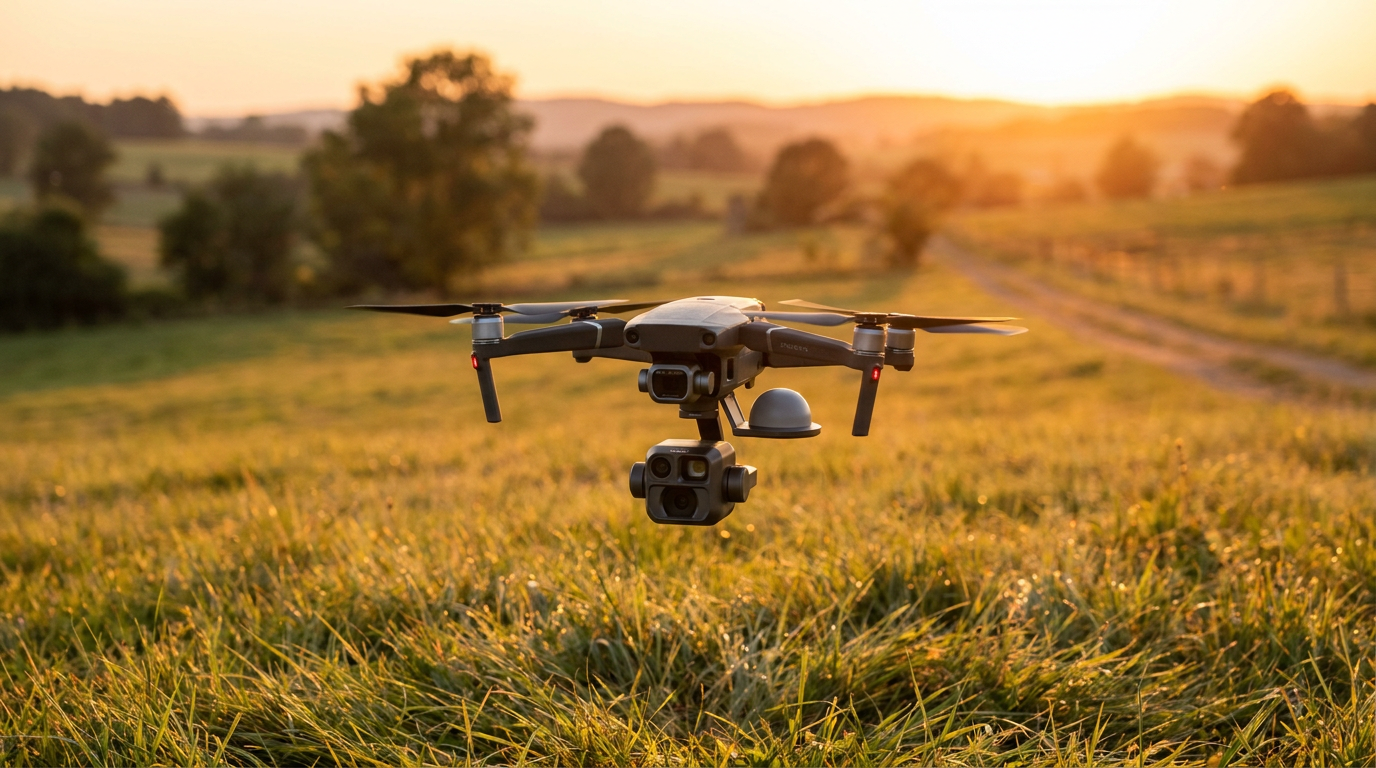
The breakthrough lies in moving the initial detection phase from the ground to the air. Modern systems utilize commercially available drones equipped with a combination of ground-penetrating radar, multispectral cameras, and thermal imaging sensors. By flying low over suspected hazardous areas, these drones can map vast tracts of land without ever putting a human foot in danger.[4][6][8]

However, capturing the data is only half the battle; the true innovation is how that data is processed. Machine learning algorithms are now trained on massive datasets of electromagnetic and thermal signatures, allowing them to differentiate between the specific profile of a buried landmine and a discarded tin can. These neural networks analyze the shape, density, and material composition of underground anomalies with remarkable precision.[3][8]
Academic research has rigorously validated these capabilities. Studies evaluating the use of deep learning on ground-penetrating radar data have demonstrated that neural networks can successfully discriminate between potential targets and harmless clutter with accuracy rates ranging from 89 to 92 percent. This level of algorithmic confidence is what allows software to filter out the noise that has historically plagued metal detectors.[3]
Academic research has rigorously validated these capabilities.
In the field, the results are already tangible. Companies specializing in AI-driven threat detection have processed millions of drone images to map explosive hazards in active and post-conflict zones. One such platform recently celebrated mapping over 23,000 explosive threats, utilizing cloud-based machine learning to deliver precision GPS-tagged hazard maps to ground teams.[5]
The military is also driving rapid advancements that are quickly trickling down to commercial and humanitarian applications. In 2026, the U.S. Army deployed a transformative drone-based intelligence kit that combines ground-penetrating radar and multispectral imaging with onboard AI processing. This military-grade sensor fusion generates near-real-time hazard maps, a capability that is already disrupting the commercial drone industry and setting new standards for terrain surveying.[4]
Similar robotic platforms have proven their mettle in rigorous international exercises. During recent NATO-led drills in Eastern Europe, an AI-enabled robotic system successfully identified and neutralized anti-personnel mines with a 94 percent detection accuracy rate, even in rugged and unforgiving terrains. This level of reliability is prompting governments and defense agencies to heavily fund the deployment of intelligent clearance systems.[7]
Cost reduction is another massive advantage of this technological shift. Initiatives like the Mine Identification and Neutralization Database (MIND) leverage off-the-shelf commercial drones that cost between $1,000 and $3,000, paired with relatively inexpensive thermal cameras. By processing the thermal anomalies in the cloud, these systems eliminate the need for heavy, expensive ground-based infrastructure, democratizing access to advanced detection tools.[6]

For the human deminers on the ground, this technology is life-changing. Instead of blindly sweeping a field and investigating every piece of shrapnel, teams are handed a digital map highlighting the exact coordinates of high-probability threats. This allows them to bypass the clutter and focus their specialized skills solely on excavating and neutralizing actual ordnance.[1][8]
The implications for global development are profound. When explosive hazards are cleared, the benefits ripple outward immediately: roads can be built, agricultural land can be farmed, and displaced families can return home safely. In regions where landmines have stalled infrastructure projects for decades, the acceleration of clearance timelines directly correlates with economic revival.[2][7]

Despite the optimism, experts acknowledge that transparent uncertainties remain. AI models can struggle in areas with dense jungle canopy that blocks aerial sensors, and extreme weather conditions can degrade thermal imaging accuracy. Furthermore, deeply buried munitions or those made entirely of plastic still pose significant detection challenges that require ongoing algorithmic refinement.[1][6][8]
Nevertheless, the integration of artificial intelligence and drone technology represents the most significant leap forward in humanitarian demining since the invention of the metal detector. By drastically reducing false positives, lowering operational costs, and keeping humans out of the initial search grid, these innovations are charting a realistic path toward a world free of hidden explosives.[1][8]
How we got here
1940s
Metal detectors become the standard tool for mine clearance following World War II.
1997
The Ottawa Treaty is signed, banning anti-personnel landmines and accelerating global humanitarian clearance efforts.
2010s
Early experiments begin mounting basic visible-color cameras on commercial drones for aerial surveying.
2024
AI-enabled robotic platforms achieve 94% detection accuracy during NATO-led field exercises.
2026
Advanced sensor-fusion kits combining GPR, thermal, and AI are widely deployed, disrupting traditional clearance methods.
Viewpoints in depth
Humanitarian Demining NGOs
Focused on maximizing safety and returning land to communities as quickly as possible.
Organizations like the HALO Trust and UNMAS view AI and drones as a massive force multiplier. Their primary pain point has always been the overwhelming number of false positives generated by traditional metal detectors, which forces deminers to waste hours digging up harmless scrap metal. By adopting aerial sensor fusion, these groups hope to filter out the noise, allowing their human teams to focus exclusively on confirmed threats. This shift not only drastically improves the safety of their personnel but also accelerates the timeline for returning fertile agricultural land to displaced communities.
Defense Technology Developers
Focused on advancing sensor fusion, algorithmic accuracy, and scaling commercial applications.
For defense contractors and commercial drone manufacturers, the challenge is an engineering and data problem. They are focused on miniaturizing ground-penetrating radar and thermal sensors so they can be carried by off-the-shelf commercial drones. By leveraging cloud computing and massive proprietary datasets of explosive signatures, these developers are pushing machine learning models to achieve accuracy rates above 90 percent. They also see a lucrative dual-use market, where technology developed for military route clearance can be sold to humanitarian organizations and commercial surveyors.
Academic Researchers
Focused on the underlying physics, data integrity, and empirical validation of detection models.
The academic community is primarily concerned with the rigorous testing and validation of these new detection methods. Researchers are publishing peer-reviewed studies on how different neural network architectures interpret electromagnetic induction and ground-penetrating radar data. While they celebrate the high accuracy rates achieved in controlled environments, they also caution against over-reliance on AI in edge cases. Academics emphasize the need for diverse training data to ensure algorithms don't fail when encountering novel soil compositions, extreme weather, or deeply buried, minimum-metal mines.
What we don't know
- How effectively AI models will perform in environments with dense jungle canopy that obscures aerial sensors.
- The long-term durability and maintenance costs of deploying sophisticated sensor drones in harsh, austere environments.
- Whether regulatory bodies will impose strict certification requirements on commercial drones carrying 'high-risk' mine detection payloads.
Key terms
- UXO
- Unexploded Ordnance; explosive weapons like bombs, shells, or grenades that failed to detonate and remain hazardous.
- Ground Penetrating Radar (GPR)
- A geophysical method that uses radar pulses to image the subsurface and detect buried objects.
- Sensor Fusion
- The process of combining data from multiple different sensors, such as thermal cameras and radar, to create a more accurate understanding of an environment.
- False Positive
- In demining, an instance where a detector signals a threat, but the buried object turns out to be harmless scrap metal.
Frequently asked
Can drones physically remove the landmines?
No, drones currently map and identify the threats from the air. Human deminers or specialized robotic ground vehicles are still required to safely excavate and neutralize the ordnance.
How does AI tell the difference between a mine and scrap metal?
Machine learning models are trained on thousands of electromagnetic and thermal signatures, allowing them to distinguish the specific shape, density, and material composition of explosives from harmless debris.
Is this technology being used in active conflict zones?
Yes, AI-powered drone mapping is already being deployed in regions like Ukraine to rapidly survey contaminated agricultural land and prioritize clearance efforts.
Sources
Source coverage
8 outlets
4 viewpoints surfaced


[1]The HALO TrustHumanitarian Demining NGOs
Uncharted Ground: Transforming Landmine Clearance
Read on The HALO Trust →[2]UNMASHumanitarian Demining NGOs
An Evaluation of UNMAS: A Success Story in Danger
Read on UNMAS →[3]MDPI SensorsAcademic Researchers
GPR Signal Characterization for Automated Landmine and UXO Detection Based on Machine Learning Techniques
Read on MDPI Sensors →[4]Reboot HubDefense Technology Developers
Army's New Drone Intelligence Kit Targets Landmines: What It Means for Commercial Operators
Read on Reboot Hub →[5]Safe Pro GroupDefense Technology Developers
Safe Pro Celebrates 50,000th AI-Powered Landmine Detection Milestone
Read on Safe Pro Group →[6]EU Assets PlusHumanitarian Demining NGOs
The Mine Identification and Neutralization Database (MIND)
Read on EU Assets Plus →[7]Congruence Market InsightsDefense Technology Developers
Global Mine Clearance System Market Report 2024
Read on Congruence Market Insights →[8]Factlen Editorial TeamIndependent Analysts
Synthesis by Factlen editorial team
Read on Factlen Editorial Team →
Every angle. Every day.
Get defense security stories with full source coverage and perspective breakdowns delivered to your inbox.