How Polynesian Wayfinders Navigate the Pacific Without Instruments
The ancient science of non-instrument navigation is experiencing a global renaissance, driven by the ongoing Moananuiākea Voyage and a profound respect for the natural world.
By Factlen Editorial Team
- Traditional Wayfinders
- View wayfinding as a spiritual and physical discipline requiring intense observation and respect for natural limits.
- Indigenous Cultural Advocates
- See the revival of non-instrument navigation as a critical victory against the erasure of Indigenous history and a tool for decolonization.
- Environmental Observers
- Highlight the canoe as a platform for climate science, noting that navigators' sensitivity to nature provides vital data on ocean health.
What's not represented
- · Modern Maritime Regulators
- · Commercial Shipping Operators
Why this matters
The revival of traditional ecological knowledge proves that ancient scientific frameworks remain highly relevant today. By understanding how wayfinders read the Earth's subtle cues, we gain a powerful new perspective on climate awareness and our relationship with the natural world.
Key points
- Polynesian wayfinding relies entirely on observing stars, ocean swells, and natural signs without modern instruments.
- The mental star compass divides the horizon into 32 houses to track celestial movements.
- When clouds obscure the sky, navigators steer by feeling the constant rhythm of deep-ocean swells.
- The 1976 maiden voyage of the Hōkūleʻa disproved theories that the Pacific was settled by accidental drift.
- The ongoing Moananuiākea Voyage uses traditional navigation to advocate for global ocean conservation and climate awareness.
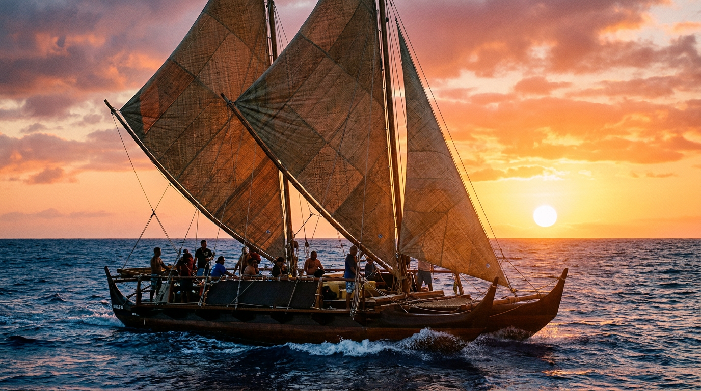
In the summer of 2026, the legendary Polynesian voyaging canoe Hōkūleʻa sits docked in Aotearoa (New Zealand). Its crew is waiting. They are in the midst of the Moananuiākea Voyage, a planned 43,000-nautical-mile circumnavigation of the Pacific Ocean. But a developing El Niño weather pattern has altered the winds and seas, forcing a delay in their departure for Tonga.[1][2]
To the crew, this pause is not a setback. "Our sail plan is going to be adjusted to what nature allows us to do," explains Nainoa Thompson, CEO of the Polynesian Voyaging Society and a master navigator. "We choose to pay attention and make our decisions... based on what weather tells us to do."[1]
This deference to nature is the foundational principle of wayfinding—the ancient art of navigating the open ocean without maps, compasses, sextants, or GPS. For thousands of years, Polynesian explorers used this profound environmental literacy to settle the largest ocean on Earth, traversing millions of square miles of open water.[4][8]
Yet, by the mid-20th century, this knowledge was on the brink of extinction. Colonization, the banning of Indigenous traditions, and the advent of modern maritime technology had nearly erased the ancient navigational arts. Western historians even theorized that the Pacific Islands had been populated by "accidental drift," assuming ancient peoples lacked the technology to purposefully navigate such vast distances.[4][6]

The Hōkūleʻa was built in the 1970s to prove that theory wrong. But the founders of the Polynesian Voyaging Society faced a critical problem: no living Hawaiian knew how to navigate the traditional way. Their search for a teacher led them to the tiny island of Satawal in Micronesia.[4][5]
There, they found Pius "Mau" Piailug, one of the last half-dozen master navigators in the world. Defying the tradition of keeping navigational secrets strictly within local families, Mau agreed to share his knowledge with the Hawaiians. In 1976, he guided the Hōkūleʻa on its maiden voyage from Hawaiʻi to Tahiti, sparking a cultural renaissance that continues today.[4][5]
So how does a human being cross thousands of miles of featureless ocean with nothing but their senses? The system relies on a staggering mental framework, beginning with the Star Compass.[8]
Unlike a western magnetic compass, the Hawaiian star compass—adapted by Thompson from Mau's teachings—is entirely mental. The navigator imagines the canoe at the exact center of a circle. The horizon is divided into 32 "houses," each separated by 11.25 degrees of arc.[1][3]

Unlike a western magnetic compass, the Hawaiian star compass—adapted by Thompson from Mau's teachings—is entirely mental.
Navigators memorize the exact houses where hundreds of specific stars rise in the east and set in the west. By aligning the canoe with a rising star, the navigator establishes a heading. As that star arcs too high into the sky to be useful, the navigator shifts their gaze to the next star rising from the same house, creating a continuous celestial roadmap.[1][6]
To measure the altitude of celestial bodies, navigators use their own bodies. By extending an arm and using the width of their fingers and hands, they can measure degrees above the horizon. A calibrated hand can determine latitude by measuring the height of the North Star (Hōkūpaʻa) or the Southern Cross.[7]

But the Pacific is frequently blanketed by clouds. When the stars, sun, and moon are hidden, the navigator must rely on the ocean itself. This is where the art of swell reading becomes critical.[1][3]
Deep-ocean swells are generated by distant, persistent weather systems, like the trade winds. Unlike surface waves, which are chaotic and driven by local weather, swells are long, rhythmic, and constant. A master navigator memorizes the "feel" of the canoe as it pitches and rolls through these primary swells.[3][8]
If a navigator knows the primary swell is rolling in from the northeast, they can hold a course in pitch darkness by keeping the canoe at a specific angle to that rolling motion. It requires intense physical sensitivity; navigators often sleep in the hull to better feel the water's movement against the wood.[3]

Speed and distance are calculated through a mental process akin to dead reckoning. A navigator watches the water pass the hull, estimating the canoe's speed in knots. Every 12 hours, at sunrise and sunset, they multiply that speed by the time elapsed to calculate the distance traveled—typically around 120 miles a day for the Hōkūleʻa.[1]
Perhaps the most profound difference in traditional wayfinding is philosophical. In Western navigation, the vessel moves across a static map. In Polynesian wayfinding, the canoe is stationary. The navigator envisions the canoe at the center of the universe, and through their sheer will and alignment with nature, the destination island is "pulled" toward them over the horizon.[3][8]
Today, the Moananuiākea Voyage is not just about preserving the past; it is about navigating the future. The Polynesian Voyaging Society calls this a "Voyage for Earth," aiming to inspire a new generation of "planetary navigators."[1]
The skills required to sail a canoe—intense observation, deep respect for natural limits, and collective responsibility—are the exact skills required to manage a planet in the midst of a climate crisis. The navigators observe firsthand the changing ocean temperatures, shifting weather patterns, and the depletion of marine life.[1][6]

The revival of this knowledge has spread far beyond Hawaiʻi. Today, voyaging societies exist in Aotearoa, Tahiti, the Cook Islands, and Micronesia. New generations of navigators are being inducted into the sacred Pwo ranks, ensuring the unbroken chain of knowledge continues.[5]
How we got here
1973
The Polynesian Voyaging Society is founded to prove ancient Polynesians purposefully navigated the Pacific.
1976
The Hōkūleʻa completes its maiden voyage from Hawaiʻi to Tahiti, guided by master navigator Mau Piailug.
2007
Master navigator Mau Piailug inducts a new generation of Hawaiians into the sacred Pwo ranks on the island of Satawal.
June 2023
The Moananuiākea Voyage begins, launching a multi-year circumnavigation of the Pacific Ocean.
Mid-2026
The voyage pauses in Aotearoa (New Zealand) to wait out unpredictable weather patterns caused by a strong El Niño.
Viewpoints in depth
Traditional Wayfinders
Navigating by aligning with nature rather than dominating it.
For the navigators and crew members of the Polynesian Voyaging Society, wayfinding is a spiritual and physical discipline. They argue that the canoe is a microcosm of the Earth; survival depends on intense observation, deep respect for natural limits, and collective responsibility. By reading the stars, swells, and wind, they maintain a living connection to their ancestors and demonstrate that traditional ecological knowledge remains highly relevant in the modern era.
Indigenous Cultural Advocates
Wayfinding as a tool for decolonization and cultural pride.
Cultural historians and advocates view the revival of non-instrument navigation as a critical victory against the erasure of Indigenous history. For decades, Western anthropologists dismissed the settlement of the Pacific as 'accidental drift.' The success of the Hōkūleʻa dismantled this narrative, restoring pride in Polynesian ingenuity. Today, the canoe serves as a floating classroom, revitalizing native languages, canoe-building crafts, and community bonds across the Pacific.
Environmental Observers
The canoe as a platform for climate science and ocean conservation.
Scientists and environmentalists highlight the Moananuiākea Voyage's role in global climate advocacy. Because traditional navigators rely entirely on natural cues, they are acutely sensitive to environmental changes. Observers note that the crew's firsthand experiences with shifting trade winds, altered ocean temperatures, and unpredictable El Niño patterns provide powerful, qualitative data that complements modern climate science, urging global action to protect the oceans.
What we don't know
- Exactly how climate change and shifting weather patterns will permanently alter the deep-ocean swells navigators rely on.
- The precise timeline for the remainder of the Moananuiākea Voyage, which is continuously adjusted based on El Niño conditions.
Key terms
- Wayfinding
- The art and science of navigating open-ocean voyages without modern instruments, relying instead on stars, swells, and natural signs.
- Star Compass
- A mental framework used by navigators that divides the horizon into 32 houses to track the rising and setting of celestial bodies.
- Pwo
- A sacred initiation and title for a master navigator in the Micronesian tradition, signifying both deep knowledge and spiritual responsibility.
- Moananuiākea
- A Hawaiian word referring to the vast, expansive waters of the Pacific Ocean.
- Dead Reckoning
- The process of calculating one's current position by using a previously determined position and advancing that position based upon known or estimated speeds over elapsed time.
Frequently asked
What is the Hōkūleʻa?
The Hōkūleʻa is a traditional Polynesian double-hulled voyaging canoe built in the 1970s to revive the ancient art of non-instrument navigation.
How do navigators steer when it's cloudy?
When celestial bodies are hidden, navigators rely on ocean swells. They memorize the constant rhythm of deep-ocean trade swells and hold their course by feeling how the canoe pitches and rolls against the water.
Who was Mau Piailug?
Pius "Mau" Piailug was a master navigator from Satawal, Micronesia. In the 1970s, he shared his closely guarded navigational knowledge with Hawaiians, sparking a Pacific-wide cultural renaissance.
What is the Moananuiākea Voyage?
It is an ongoing 43,000-nautical-mile circumnavigation of the Pacific Ocean by the Hōkūleʻa and its sister canoes, aimed at inspiring global ocean conservation.
Sources
Source coverage
8 outlets
3 viewpoints surfaced


[1]Polynesian Voyaging SocietyTraditional Wayfinders
Moananuiākea Voyage | 2026 Update
Read on Polynesian Voyaging Society →[2]Hawaii Public RadioIndigenous Cultural Advocates
Hōkūleʻa crew delays departure for Tonga due to El Niño
Read on Hawaii Public Radio →[3]KTOOTraditional Wayfinders
How the Hōkūleʻa navigates the ocean without instruments
Read on KTOO →[4]Science Learning HubEnvironmental Observers
The Polynesian Voyaging Society
Read on Science Learning Hub →[5]Cambridge University PressIndigenous Cultural Advocates
Revitalizing Canoe Culture in Yap and Its Outer Islands
Read on Cambridge University Press →[6]Katie Couric MediaEnvironmental Observers
The Voyage That Changed Me: Hōkūleʻa and the Hawaiian Renaissance
Read on Katie Couric Media →[7]Polynesian Cultural CenterTraditional Wayfinders
A Master’s Touch: Restoring the Traditional Art of Polynesian Navigation
Read on Polynesian Cultural Center →[8]Factlen Editorial TeamEnvironmental Observers
Synthesis by Factlen editorial team
Read on Factlen Editorial Team →
Every angle. Every day.
Get culture stories with full source coverage and perspective breakdowns delivered to your inbox.