Federal Government Prepares to Impose Colorado River Cuts as States Deadlock Over 'Missing Water'
With negotiations stalled and reservoirs nearing critical lows, the Bureau of Reclamation is preparing a 10-year federal mandate to manage the Colorado River. New climate data reveals that warmer springs are permanently reducing the river's flow, forcing a reckoning for the 40 million people who rely on it.
By Factlen Editorial Team
- Upper Basin Advocates
- Argue that their water use is naturally restricted by yearly snowpack, meaning they already absorb de facto cuts.
- Lower Basin Advocates
- Advocate for predictable, shared reductions across all states to protect reservoir elevations.
- Federal Regulators
- Prioritize the physical survival of the dam infrastructure and are prepared to mandate severe cuts.
- Scientific Consensus
- Emphasize that the basin is experiencing permanent aridification, requiring a fundamental baseline shift.
What's not represented
- · Indigenous Tribes of the Colorado River Basin
- · Mexican Water Authorities
- · Agricultural Sector Representatives
Why this matters
The Colorado River supplies drinking water and electricity to 40 million people and irrigates the agriculture that feeds much of the nation. If the federal government forces unprecedented cuts or the reservoirs reach dead pool, it will trigger massive disruptions to food prices, urban water security, and the broader Western economy.
Key points
- The Bureau of Reclamation will impose a 10-year management plan by late summer if basin states cannot agree on water cuts.
- Under a federal 'no deal' scenario, Arizona could face a devastating 77% reduction in its Colorado River water allocation.
- Lake Powell is forecasted to receive only 15% of its normal spring inflow, pushing the reservoir closer to 'dead pool' status.
- New research shows warmer springs are causing plants to absorb snowmelt before it reaches the river, explaining 70% of the basin's missing water.
- The basin has lost 27.8 million acre-feet of groundwater since 2002, removing a critical buffer against surface water shortages.
The Colorado River Basin is officially out of time. For years, the seven Western states that rely on the waterway have engaged in tense, largely fruitless negotiations over how to share a rapidly shrinking resource. Now, with the river's worst water year on record unfolding and a critical 2026 deadline looming, the federal government has issued an unprecedented ultimatum. The era of voluntary consensus appears to be ending, replaced by the stark reality of mandated reductions that will reshape the region's economy.[1][2]
At a June 2026 water conference in Boulder, Colorado, the Bureau of Reclamation announced that it will impose a comprehensive 10-year operating framework by the end of the summer if the states cannot reach a consensus. The announcement marks a sharp escalation in the long-running dispute over the river, which supplies drinking water to 40 million people and irrigates over 5 million acres of cropland across the American West and Mexico. Federal officials have made it clear that they will not allow the system to collapse while states bicker over allocations.[2][6]
The stakes of a federal mandate are existential for some regions. Under the "no deal" proposal drafted by the Bureau of Reclamation, Arizona could face a staggering 77 percent cut to its share of the river's water. Nevada would see a 6 percent reduction, while the other five states would experience no immediate changes to their allocations. This disproportionate impact has triggered a scramble among Lower Basin states to find an alternative, but fundamental disagreements over water accounting and historical rights remain deeply entrenched.[1][6]
The urgency of the federal intervention is driven by catastrophic hydrological data that leaves no room for political maneuvering. The Bureau of Reclamation's June 2026 forecast projects that Lake Powell will receive just 15 percent of its normal water inflow between April and July. This grim forecast follows a winter that ranked among the warmest on record, leaving snowpack across the Upper Basin at near-record lows and accelerating evaporative losses across the entire watershed. The physical water required to sustain the current legal agreements simply does not exist.[4][6]

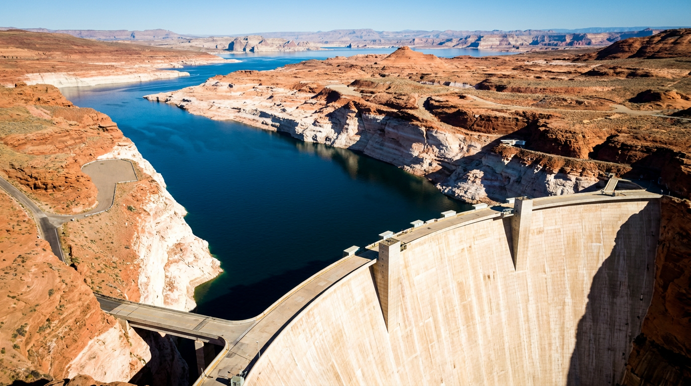
Both Lake Powell and Lake Mead—the two largest reservoirs in the United States—are hovering dangerously close to "dead pool" status. Dead pool occurs when water levels drop so low that water can no longer flow downstream through the dams, effectively cutting off supply to millions and halting hydroelectric power generation. Lake Mead is currently sitting at roughly 1,048 feet above sea level; if it drops to 895 feet, the entire delivery system crashes, triggering a regional emergency unlike anything the modern West has ever experienced.[5][6]
For decades, water managers have been puzzled by a phenomenon known as the river's "missing water." Even in years with promising winter snowpack in the Rocky Mountains, the volume of water that ultimately reached the river consistently fell short of forecasts. This discrepancy forced planners to rely on outdated models that consistently overestimated the basin's available supply, leading to chronic over-allocation and a false sense of security among agricultural and municipal users who believed the river would eventually return to its historical averages.[3][6]
A landmark April 2026 study from the University of Washington finally solved the mystery of the missing runoff: warmer, drier spring seasons are redirecting the snowmelt before it ever reaches the riverbed. The research revealed that a lack of spring rainfall combined with clearer, sunnier skies has fundamentally altered the region's ecology. Instead of flowing downstream to fill reservoirs, the water is being intercepted by the landscape itself in a process that traditional hydrological models previously failed to capture accurately.[3]
In this warmer environment, vegetation wakes up earlier in the year and grows more aggressively. Thirsty plants and dry, parched soils are absorbing the melting snow at unprecedented rates. According to the researchers, this early plant absorption and increased soil evaporation explain nearly 70 percent of the difference between predicted snowpack runoff and actual river flows. The mountains are still catching snow, but the warming atmosphere is ensuring that a massive fraction of it never reaches the people who depend on it.[3]

In this warmer environment, vegetation wakes up earlier in the year and grows more aggressively.
This shift underscores a critical consensus among climate scientists and hydrologists: the Colorado River Basin is no longer experiencing a temporary "drought." Instead, it is undergoing permanent aridification. The baseline climate has fundamentally changed, and the 15 million acre-feet of water originally allocated by the 1922 Colorado River Compact simply no longer exists. Continuing to manage the river as if those historical flows will eventually return is a recipe for infrastructural and economic disaster, requiring a complete paradigm shift in how water is valued.[5][6]
The surface water deficit is only half of the unfolding crisis. As river deliveries have become less reliable over the past two decades, agricultural and municipal users have increasingly turned to groundwater pumping to make up the difference. NASA satellite observations reveal the staggering scale of this hidden deficit: between 2002 and 2024, aquifers in the Colorado River Basin lost approximately 27.8 million acre-feet of groundwater, a volume that dwarfs the capacity of the surface reservoirs and represents a massive overdraft of the region's ultimate backup supply.[6]
This subterranean depletion removes a vital buffer against dry years. Unlike surface reservoirs, which can partially recover during a single exceptionally wet winter, deep aquifers take centuries or even millennia to recharge. The combination of dwindling river flows and exhausted groundwater puts the region's food production and urban water security at severe risk within the next decade, leaving communities with virtually no safety net when the next dry cycle hits. The basin is effectively burning through its savings account to mask a permanent cut in its income.[5][6]
The political deadlock over how to manage this decline is deeply rooted in the structural differences between the Upper Basin (Colorado, Utah, Wyoming, New Mexico) and the Lower Basin (Arizona, California, Nevada). The Upper Basin relies directly on annual snowmelt and smaller, high-altitude reservoirs, making their water supply highly variable from year to year. The Lower Basin, by contrast, relies on the massive, multi-year storage buffers provided by Lake Mead and Lake Powell to ensure predictable deliveries.[1][2]
Upper Basin negotiators argue that their water users already take de facto, uncompensated cuts every time there is a dry winter, because the physical water simply isn't there to divert from the streams. They maintain that the Lower Basin has historically been shielded from the immediate impacts of dry years by draining the massive reservoirs, and must now bear the brunt of the reductions to bring the system back into balance. From their perspective, the Lower Basin has been living beyond its means for decades.[1][6]

Conversely, the Lower Basin states argue for a shared, basin-wide approach to cuts that respects historical compacts while acknowledging current scarcity. They have proposed a temporary bridge plan that would spread reductions across the Lower Basin over the next three years, emphasizing voluntary conservation compensated by federal funds. However, the Upper Basin rejected this proposal outright, arguing it fails to align water use with actual, real-time snowpack levels and merely delays the necessary structural reforms required to save the river.[6]
With the 2007 operating guidelines set to expire at the end of 2026, the window for a negotiated settlement is rapidly closing. The Bureau of Reclamation is scheduled to release its final Environmental Impact Statement in mid-summer, which will detail the federal government's preferred 10-year management plan. If the states cannot present a unified alternative before that document is finalized, the federal government will step in and dictate the terms of survival for the entire basin, overriding decades of state-led water management.[2]
If the federal government imposes its framework, the decision is almost certain to trigger massive, protracted litigation. State negotiators have openly acknowledged the risk of the dispute ending up in the Supreme Court, a scenario that would introduce years of legal uncertainty into an already volatile water market. A prolonged court battle would paralyze long-term infrastructure planning, stall conservation investments, and leave farmers and cities guessing about their future water rights while the reservoirs continue to drain.[1][6]

Regardless of the legal outcomes, the physical reality of the river dictates the future. As the Colorado River Research Group noted in their recent assessment, the basin is "dancing with deadpool," and even a historically wet year would only provide a brief, two-year reprieve from the structural deficit. The math is indisputable: the basin consumes far more water than nature provides, and no amount of litigation or political maneuvering can force a dry riverbed to yield more water than the climate allows.[5]
The era of treating the Colorado River as a reliable, static resource has definitively ended. Moving forward, the 40 million residents of the basin face an unavoidable transition: adapting to a permanently smaller river, fundamentally restructuring agricultural water use, and accepting that the legal rights of the 20th century cannot conjure water in the 21st. The only remaining question is whether that transition will be managed cooperatively, or forced upon the region by federal mandate and ecological collapse.[5][6]
How we got here
1922
The Colorado River Compact is signed, allocating 15 million acre-feet of water based on historically wet baseline data.
2000
A prolonged period of severe drought and aridification begins, steadily draining the basin's major reservoirs.
2007
The seven basin states agree to interim operating guidelines to manage shortages, set to expire in 2026.
February 2023
Lake Powell hits its all-time lowest elevation of 3,522 feet above sea level.
January 2026
The Bureau of Reclamation issues draft alternatives for post-2026 operations after states fail to reach a consensus.
June 2026
Federal officials announce they will impose a 10-year management framework by late summer if the deadlock continues.
Viewpoints in depth
Upper Basin States
Argue that their reliance on natural snowpack means they already absorb the impacts of dry years.
Negotiators for Colorado, Utah, Wyoming, and New Mexico maintain that their water users take de facto cuts every year the snowpack is low, because they lack the massive storage buffers of the Lower Basin. They argue that any new agreement must force the Lower Basin to align its water consumption with actual, real-time hydrology, rather than relying on fixed reservoir releases.
Lower Basin States
Advocate for predictable, shared reductions to protect reservoir elevations.
Arizona, California, and Nevada argue that the entire basin must share the burden of a shrinking river. They have proposed spreading cuts across the Lower Basin over the next three years, emphasizing voluntary conservation compensated by federal funds. They warn that sudden, draconian cuts to a single state—like the 77% reduction threatened for Arizona—would devastate local economies and agricultural supply chains.
Federal Regulators
Prioritize the physical survival of the dam infrastructure above state allocations.
The Bureau of Reclamation's primary mandate is to prevent the catastrophic failure of the Colorado River system. With Lake Powell and Lake Mead nearing dead pool, federal officials view the state-level bickering as a luxury the basin can no longer afford. They are prepared to unilaterally impose a 10-year operating framework to ensure water continues to flow through the dams and generate hydroelectric power.
What we don't know
- Whether the states will launch a Supreme Court challenge if the federal government imposes its 10-year framework.
- How the federal government plans to compensate states or farmers for mandated water conservation.
- The exact timeline for when Lake Mead or Lake Powell could hit dead pool if current consumption rates continue.
Key terms
- Aridification
- The gradual, long-term process of a region becoming increasingly dry, representing a permanent climate shift rather than a temporary drought.
- Dead pool
- The point at which a reservoir's water level falls below the lowest outlet works, preventing water from flowing through the dam.
- Acre-foot
- The volume of water required to cover one acre of land to a depth of one foot, roughly equivalent to 326,000 gallons.
- Upper Basin
- The portion of the Colorado River watershed above Lees Ferry, Arizona, comprising Colorado, Utah, Wyoming, and New Mexico.
- Lower Basin
- The portion of the watershed below Lees Ferry, comprising Arizona, California, and Nevada.
Frequently asked
What is 'dead pool' in a reservoir?
Dead pool occurs when water levels drop so low that water can no longer flow downstream through the dam, halting both water deliveries and hydroelectric power generation.
Why is the federal government getting involved?
The current agreement between the seven basin states expires at the end of 2026. Because the states have failed to negotiate a new deal, the Bureau of Reclamation is preparing to mandate a 10-year framework to prevent the reservoirs from failing.
Where is the river's 'missing water' going?
Warmer, drier spring seasons are causing plants to wake up earlier and absorb melting snow before it can reach the river, explaining nearly 70% of the shortfall between snowpack and river flow.
Which states rely on the Colorado River?
The basin is divided into the Upper Basin (Colorado, Utah, Wyoming, New Mexico) and the Lower Basin (Arizona, California, Nevada).
Sources
Source coverage
6 outlets
4 viewpoints surfaced


[1]The New York TimesUpper Basin Advocates
Tensions Are Rising Between States That Rely on the Colorado River
Read on The New York Times →[2]Inside Climate NewsLower Basin Advocates
Feds Will Soon Impose New Framework on Colorado River if States Can't Agree How to Manage It
Read on Inside Climate News →[3]University of WashingtonScientific Consensus
Warmer, Drier Springs Are Redirecting Snowmelt Before It Reaches the Colorado River
Read on University of Washington →[4]US Bureau of ReclamationFederal Regulators
Lower Colorado River Operations: Reservoir Elevations and Forecasts
Read on US Bureau of Reclamation →[5]Colorado River Research GroupScientific Consensus
Colorado River Insights 2025: Dancing with Deadpool
Read on Colorado River Research Group →[6]Factlen Editorial TeamFederal Regulators
Synthesis by Factlen editorial team
Read on Factlen Editorial Team →
Every angle. Every day.
Get science stories with full source coverage and perspective breakdowns delivered to your inbox.