The Colorado River's 2026 Deadline: The Evidence Behind the Looming Water Crisis
The legal framework governing the Colorado River expires at the end of 2026, forcing a showdown between seven states and the federal government over permanent water reductions.
By Factlen Editorial Team
- Lower Basin States
- Argue that climate change requires basin-wide shared reductions based on total reservoir storage.
- Upper Basin States
- Argue they already suffer natural shortages and cannot legally commit to mandatory cutbacks.
- Federal Regulators
- Prioritize preventing a system crash and maintaining dam infrastructure, willing to impose unilateral cuts.
- Hydrologists & Climate Scientists
- Warn that the structural deficit requires permanent, drastic reductions rather than temporary drought measures.
What's not represented
- · Native American Tribes with unquantified senior water rights
- · Agricultural industry representatives facing massive cuts
- · Mexican water authorities who rely on the river's delta
Why this matters
The Colorado River supplies water to 40 million Americans and irrigates 5.5 million acres of farmland. If the states cannot agree on how to share a shrinking river by the end of 2026, the federal government will impose unilateral cuts, likely triggering a Supreme Court battle that will dictate the economic future of the American Southwest.
Key points
- The legal agreements governing Colorado River water allocations expire on December 31, 2026.
- The seven basin states have failed to reach a consensus on how to share future water reductions.
- Spring 2026 runoff is projected at just 13% of the historical average, accelerating reservoir decline.
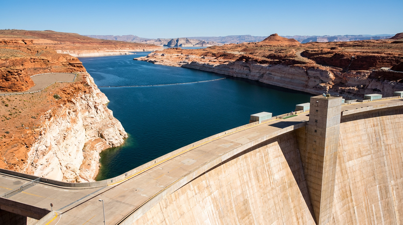
- Lake Powell is dangerously close to the 3,490-foot threshold where hydroelectric generation must halt.
- The federal government plans to impose a unilateral 10-year framework if states don't agree by October.
- Congress is threatening to withhold $354 million in conservation funding from states that pursue litigation.
For nearly two decades, the American Southwest has managed its most vital water source through a patchwork of temporary agreements and emergency drought measures. That era is coming to an abrupt end. On December 31, 2026, the 2007 Interim Guidelines and the 2019 Drought Contingency Plans—the legal frameworks that dictate how water from the Colorado River is rationed—will expire. The seven basin states have spent the last two years attempting to negotiate a permanent replacement. They have failed, missing multiple federal deadlines and pushing the region toward an unprecedented legal and hydrological crisis.[4][7]
The stakes are difficult to overstate. The Colorado River sustains 40 million people across seven states and Mexico, and it irrigates 5.5 million acres of agricultural land. The system is currently operating at a massive structural deficit. Between 2000 and 2024, the river's flows averaged just 12.4 million acre-feet per year, while consumptive use hovered around 13.3 million acre-feet. This mathematical impossibility has been temporarily masked by draining the nation's two largest reservoirs, Lake Mead and Lake Powell, which are now approaching critical operational thresholds.[4][8]
The hydrological evidence for 2026 paints a grim picture. According to the NOAA Colorado Basin River Forecast Center, the current runoff forecast for April to July is a staggering 13 percent of the historical average—roughly 800,000 acre-feet compared to the usual 6 million. Climate scientists note that the basin experienced a record-breaking dry winter, exacerbated by the warmest March on record across every basin state. This combination of low snowpack and high temperatures means that precipitation increasingly evaporates or soaks into parched soil before it ever reaches the river.[5][6]
This lack of inflow is accelerating the decline of the reservoir system. As of June 2026, Lake Mead sits at 1,048 feet above sea level, roughly 180 feet below its full capacity. Upstream, Lake Powell is hovering at 3,527 feet, sitting at just 23 percent of its total capacity. These numbers are not merely aesthetic concerns; they dictate the physical operation of the dams. If Lake Powell falls below 3,490 feet—the "minimum power pool"—water will no longer flow through the turbines of the Glen Canyon Dam, halting hydroelectric power generation for millions of customers.[5][6]

If water levels continue to drop, the system faces an even more severe threat: "dead pool." At 3,370 feet for Lake Powell and 895 feet for Lake Mead, the water level falls below the lowest intake valves. At that point, the reservoirs become stagnant lakes, unable to release water downstream. Researchers at the University of Colorado have warned that the system is on track for a potential "system crash" within the next few years, where the multi-billion-dollar infrastructure underpinning the river can no longer function as intended.[6][8]
The root of the crisis lies in the original 1922 Colorado River Compact, which divided the river between the Upper Basin (Colorado, Wyoming, Utah, and New Mexico) and the Lower Basin (California, Arizona, and Nevada). The Compact allocated 7.5 million acre-feet to each basin, based on an assumed annual flow of 16.4 million acre-feet. Hydrologists now know that the early 20th century was an unusually wet period. The river has rarely produced that much water, and climate change is ensuring it likely never will again.[4][7]

The Compact allocated 7.5 million acre-feet to each basin, based on an assumed annual flow of 16.4 million acre-feet.
Faced with this reality, the states are deadlocked over who must absorb the losses. In May 2026, the Lower Basin states submitted a joint proposal to the Bureau of Reclamation, offering to reduce their usage by 1.25 million acre-feet annually through 2028. However, their proposal insists that future reductions must be shared across all seven states and triggered by the total combined storage of all reservoirs in the basin, rather than just the water level at Lake Mead.[1][3]
The Upper Basin states categorically reject this approach. They argue that they already suffer "natural shortages"—when snowpack is low, their rivers run dry before the water ever reaches the federal reservoirs, forcing their farmers to take immediate cuts. Furthermore, Upper Basin leaders maintain that they cannot legally commit to mandatory cutbacks because doing so would require stripping senior water rights from landowners, potentially exposing the states to billions of dollars in liability.[3][6]
With the states at an impasse, the federal government is preparing to intervene. The Bureau of Reclamation has announced that it will release a final Environmental Impact Statement by mid-summer, detailing the federal government's preferred plan for managing the river post-2026. If the states cannot reach a consensus by October 1, the Department of the Interior intends to impose a 10-year operating framework unilaterally. Federal officials have warned that their primary mandate is to protect the dam infrastructure, and that their imposed solution will likely leave everyone unhappy.[2][8]

A federally imposed solution is almost certain to trigger massive litigation. States on both sides of the divide are already preparing for a Supreme Court battle. Arizona has secured an outside law firm specifically for Colorado River matters, and Colorado's governor has publicly stated his confidence that his state would prevail on the merits of the 1922 Compact. A court battle would plunge the region into years of legal uncertainty precisely when rapid, coordinated adaptation is required.[1][3]
In an attempt to force a compromise, Congress is wielding its financial leverage. During a recent Senate Energy and Natural Resources Committee hearing, lawmakers warned the states that they would lose access to roughly $354 million in federal conservation aid if they pursue litigation. "Federal taxpayers should not be asked to subsidize litigation among the states," warned Senator Mike Lee, emphasizing that Congress will not reward states that choose to sue their neighbors over river operations.[1][8]
Complicating the negotiations is the rapid depletion of groundwater across the basin. As surface water from the Colorado River has become less reliable, states like Arizona have increasingly relied on pumping water from underground aquifers. NASA satellite observations indicate that between 2002 and 2024, the basin's aquifers lost nearly 28 million acre-feet of groundwater. This hidden deficit means that states have fewer backup reserves to rely on when the federal government inevitably slashes their river allocations.[8]
The elephant in the room remains agricultural water use. While urban centers like Las Vegas and Los Angeles have invested billions in water recycling and conservation—successfully decoupling their population growth from their water demand—agriculture still consumes roughly 80 percent of the Colorado River's flow. Crops like alfalfa, which is highly water-intensive and often exported overseas, remain a flashpoint in the debate over how to prioritize a shrinking resource.[8]
Ultimately, the physics of the river will dictate the outcome. The era of relying on temporary, voluntary conservation measures to bridge the gap is over. The structural deficit is no longer a future projection; it is the current reality. Whether through a last-minute consensus, a federal mandate, or a Supreme Court ruling, the seven basin states must permanently align their consumption with the river's diminished 21st-century hydrology.[6][8]
How we got here
1922
The Colorado River Compact is signed, dividing 15 million acre-feet of water between the Upper and Lower Basins based on unusually wet historical data.
2007
The Bureau of Reclamation implements Interim Guidelines to manage shortages as a prolonged drought begins to drain the reservoirs.
2019
The states agree to Drought Contingency Plans, offering temporary, voluntary water reductions to prevent Lake Mead from crashing.
May 2026
The Lower Basin states submit a proposal for post-2026 operations, which the Upper Basin rejects, resulting in a deadlock.
October 2026
The federal deadline for the Bureau of Reclamation to impose a unilateral 10-year water management framework if the states cannot agree.
December 31, 2026
The 2007 Interim Guidelines and 2019 Drought Contingency Plans officially expire.
Viewpoints in depth
The Lower Basin's View
California, Arizona, and Nevada argue that climate change requires a shared, basin-wide approach to water reductions.
The Lower Basin states maintain that the current system unfairly places the burden of drought on them, as reductions are currently triggered solely by the water levels in Lake Mead. In their post-2026 proposal, they advocate for a new framework where mandatory cuts are determined by the total combined storage of all reservoirs across the entire basin. They argue that because climate change is shrinking the river as a whole, the Upper Basin must share the pain of mandatory, permanent reductions to stabilize the system.
The Upper Basin's View
Colorado, Utah, Wyoming, and New Mexico argue they already suffer natural shortages and cannot legally force mandatory cuts.
The Upper Basin states fundamentally reject the premise that they should bear the burden of the Lower Basin's historical overuse. They point out that they rely on natural river flows rather than massive federal reservoirs; when snowpack is low, their rivers run dry, and their users take immediate, uncompensated cuts. Furthermore, Upper Basin leaders argue that their state laws regarding senior water rights prevent them from legally committing to the mandatory, preemptive cutbacks demanded by the Lower Basin, warning that such actions would trigger massive domestic lawsuits.
The Federal Regulators' View
The Bureau of Reclamation prioritizes protecting dam infrastructure and preventing a total system collapse.
For the Department of the Interior and the Bureau of Reclamation, the primary mandate is physical rather than political. Their models show that without drastic intervention, the reservoirs could hit 'dead pool,' destroying the hydroelectric grid and halting water deliveries entirely. Federal officials have signaled deep frustration with the states' inability to compromise and have made it clear that they are prepared to impose a unilateral 10-year framework by October 2026 to protect the dams, even if it guarantees years of Supreme Court litigation.
What we don't know
- How the Supreme Court would interpret the 1922 Colorado River Compact in the context of a modern, climate-driven megadrought.
- Whether the federal government's final Environmental Impact Statement will force deeper cuts on California's senior water rights or Arizona's junior rights.
- How agricultural communities will economically survive the inevitable, permanent reductions in their water allocations.
Key terms
- Acre-foot
- The volume of water needed to cover one acre of land to a depth of one foot, roughly 326,000 gallons, which is enough to supply two to three households for a year.
- Structural Deficit
- The ongoing mathematical gap between the amount of water legally allocated to the states and the actual, much lower amount of water flowing through the river system.
- Minimum Power Pool
- The lowest water elevation at which a dam's turbines can safely generate hydroelectric power before the water must bypass the generators.
- Dead Pool
- The critical threshold where reservoir water levels fall below the lowest intake valves, meaning water can no longer flow downstream through the dam.
- Law of the River
- The complex web of compacts, federal laws, court decisions, and international treaties that dictate how the Colorado River is managed and divided.
Frequently asked
What happens on December 31, 2026?
The current legal frameworks that manage drought shortages on the Colorado River expire. If no new agreement is in place, the river will lack a coordinated system for rationing water.
Why are the states fighting over the water?
The river produces far less water than was originally allocated in 1922. The states are deadlocked over who should be forced to take permanent cuts to their water usage to balance the system.
Can the federal government force a solution?
Yes. The Secretary of the Interior has the authority to impose unilateral water cuts to protect federal dam infrastructure, though the states would likely challenge this in the Supreme Court.
What happens if Lake Powell hits 'dead pool'?
If the water falls below 3,370 feet, it can no longer flow through the dam's intake valves. The reservoir would become a stagnant lake, cutting off the primary water supply for the Lower Basin.
Sources
Source coverage
8 outlets
4 viewpoints surfaced


[1]The New York TimesLower Basin States
Tensions Are Rising Between States That Rely on the Colorado River
Read on The New York Times →[2]Inside Climate NewsFederal Regulators
Feds Will Soon Impose New Framework on Colorado River if States Can't Agree How to Manage It
Read on Inside Climate News →[3]Los Angeles TimesLower Basin States
With the leaders of seven states deadlocked over the Colorado River's deepening crisis, negotiations increasingly seem likely to fail
Read on Los Angeles Times →[4]Congressional Research ServiceFederal Regulators
Management of the Colorado River: Water Allocations, Drought, and the Federal Role
Read on Congressional Research Service →[5]NOAA Colorado Basin River Forecast CenterHydrologists & Climate Scientists
Water Year 2026 Runoff Forecasts and Hydrologic Conditions
Read on NOAA Colorado Basin River Forecast Center →[6]University of Colorado BoulderUpper Basin States
Searching for Solutions in the Face of Uncertainty: 46th Annual Colorado River Conference
Read on University of Colorado Boulder →[7]National Agricultural Law CenterUpper Basin States
The Law of the River: What Happens Post-2026?
Read on National Agricultural Law Center →[8]Factlen Editorial TeamHydrologists & Climate Scientists
Synthesis by Factlen editorial team
Read on Factlen Editorial Team →

Every angle. Every day.
Get science stories with full source coverage and perspective breakdowns delivered to your inbox.