How Open-Source Intelligence and AI Are Exposing Global Environmental Crimes
A new generation of open-source intelligence tools, powered by satellite imagery and artificial intelligence, is allowing citizen journalists and NGOs to track illegal fishing, deforestation, and pollution in real time.
By Factlen Editorial Team
- Conservation & Enforcement Agencies
- Organizations focused on translating digital intelligence into physical interdictions.
- Open-Source Investigators
- Advocates for radical transparency who believe public data can hold powerful actors accountable.
- Financial Regulators
- Authorities tracking the illicit money flows generated by environmental destruction.
What's not represented
- · Indigenous communities directly utilizing OSINT tools on the ground
- · Defense lawyers challenging the admissibility of open-source evidence
Why this matters
Environmental crimes like illegal fishing and logging generate hundreds of billions in illicit profits and devastate global ecosystems. By democratizing intelligence gathering, OSINT tools empower local communities and journalists to hold powerful actors accountable without needing state-level spy agencies.
Key points
- Civilian analysts are using open-source intelligence (OSINT) to track environmental crimes that were once invisible.
- AI and satellite radar can detect 'dark' fishing vessels even when they turn off their tracking transponders.
- High-resolution satellite imagery allows investigators to map illegal deforestation and pollution in real time.
- Financial intelligence units are using OSINT to track the money laundering networks behind ecological destruction.
- The democratization of intelligence empowers civil society to hold state and corporate actors accountable.
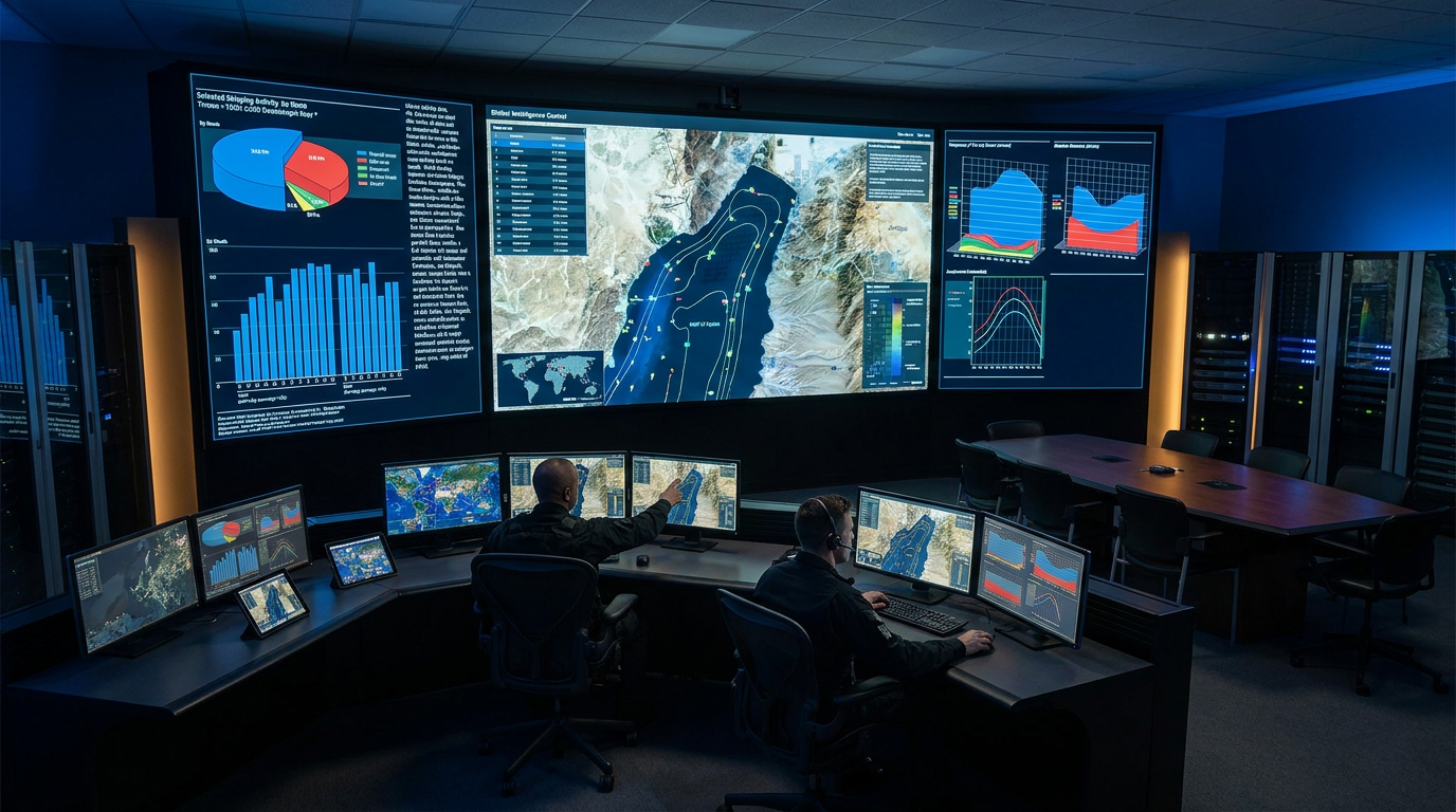
For decades, environmental crimes—from illegal logging deep in the Amazon to unregulated fishing in the vast expanse of the Pacific—relied on a simple defense: invisibility. Perpetrators operated in remote regions far beyond the reach of local law enforcement, shielded by the sheer scale of the Earth's surface. Today, that cloak of invisibility is being systematically dismantled by a decentralized network of civilian analysts, journalists, and non-governmental organizations armed with open-source intelligence (OSINT).[8]
The democratization of intelligence gathering marks a profound shift in global security. Capabilities that were once the exclusive domain of superpower spy agencies—such as high-resolution satellite tracking and global signals interception—are now accessible to anyone with a laptop and an internet connection. When combined with artificial intelligence, these tools are transforming the fight against environmental destruction from a reactive pursuit into a proactive, data-driven science.[3][7]
The most striking success of environmental OSINT is unfolding on the high seas. Historically, illegal, unreported, and unregulated (IUU) fishing vessels evaded detection by simply turning off their Automatic Identification System (AIS) transponders—a practice known as "going dark" to slip past maritime patrols.[1]
To counter this, platforms like Global Fishing Watch have developed sophisticated machine learning algorithms that cross-reference billions of AIS data points with Earth Observation (EO) satellite imagery. When a vessel deliberately disables its transponder, the sudden absence of the signal itself becomes a primary intelligence indicator, triggering automated alerts for analysts.[1][4][7]
AI models then scan the suspected area using Synthetic Aperture Radar (SAR), a technology that can detect the metallic hulls of ships through heavy cloud cover and complete darkness. By fusing these datasets, analysts can pinpoint the exact locations of dark vessels, identify suspicious rendezvous at sea used for illegal transshipment, and alert regional coast guards before the perpetrators can escape with their illicit catch.[1][4][7]

The application of OSINT extends far beyond the oceans. Investigative collectives like Bellingcat, originally known for tracking military conflicts and geopolitical crises, have increasingly turned their rigorous methodologies toward environmental accountability and ecological preservation.[2]
Using tools like the European Space Agency's Sentinel satellites, civilian investigators can access frequently updated, high-resolution optical and thermal imagery. Thermal infrared sensors can identify illegal deforestation fires in real-time, while spectrometers measure localized atmospheric pollution that governments or corporations might be attempting to conceal from public view.[2][4]
Using tools like the European Space Agency's Sentinel satellites, civilian investigators can access frequently updated, high-resolution optical and thermal imagery.
This capability was recently highlighted when analysts used historical satellite data to reveal the progression of industrial contamination in the Balkans, documenting severe pollution in areas where no official records existed. By triangulating this geospatial data with corporate registries and social media posts, investigators can link environmental damage directly to the responsible corporate entities.[2][3]

Environmental crime is not merely a conservation issue; it is a highly lucrative illicit industry that generates hundreds of billions of dollars annually. Recognizing this, financial intelligence units are increasingly integrating OSINT into their anti-money laundering frameworks to track the proceeds of ecological destruction.[6]
Initiatives like Project Anton, coordinated by international financial intelligence networks, provide toolkits that help banks and regulators identify the financial footprints of environmental crimes. By analyzing shipping and trade databases alongside corporate ownership structures, analysts can flag discrepancies in customs declarations or identify shell companies used to launder the proceeds of illegal logging and wildlife trafficking.[3][6]
The proliferation of OSINT tools has empowered civil society organizations (CSOs) to act as a formidable check on both state and corporate power. Organizations like the Environmental Investigation Agency (EIA) now operate dedicated intelligence units, training local activists in covert data collection, secure communications, and advanced OSINT methodologies.[5]
These CSOs gather field observations from indigenous communities and cross-reference them with satellite data and global trade records. The resulting intelligence packages are often robust enough to be handed directly to law enforcement agencies or international courts, bridging the gap between local environmental degradation and global accountability.[3][5]

Despite its transformative potential, the reliance on open-source data introduces distinct vulnerabilities. The most pressing concern is data integrity. AIS signals can be spoofed by sophisticated actors, creating "ghost ships" that appear to be in one location while the physical vessel is operating illegally elsewhere.[7]
Furthermore, the rapid integration of Large Language Models (LLMs) into intelligence workflows carries significant risks. If AI systems ingest unverified social media claims or synthetic location data without rigorous quality control, they can generate confident but entirely fabricated intelligence reports, misleading enforcement efforts.[7]
The legal admissibility of OSINT also remains a complex frontier. While satellite imagery and digital forensics are increasingly accepted in international tribunals, establishing an unbroken, verifiable chain of custody for open-source digital evidence requires meticulous documentation that volunteer analysts may sometimes lack.[4][8]
Ultimately, the true power of environmental OSINT lies not in replacing traditional enforcement, but in radically expanding its field of vision. By making the invisible visible, this global network of digital watchdogs is ensuring that the destruction of the natural world can no longer occur in the shadows.[8]

How we got here
2014
Bellingcat is founded, popularizing the use of citizen-led open-source intelligence.
2016
Global Fishing Watch launches its public platform, allowing anyone to track commercial fishing vessels.
2023
Advanced AI integration accelerates, allowing automated detection of dark vessels and deforestation.
2026
Financial Intelligence Units formally integrate OSINT toolkits to track environmental money laundering.
Viewpoints in depth
Open-Source Investigators
Advocates for radical transparency who believe public data can hold powerful actors accountable.
This camp, exemplified by collectives like Bellingcat, views OSINT as a democratizing force that strips the monopoly on intelligence away from state agencies. They argue that by crowdsourcing analysis and utilizing freely available satellite imagery, civil society can document environmental atrocities—from toxic spills to illegal mining—that corrupt local governments might otherwise ignore or actively cover up. Their primary focus is on establishing undeniable evidentiary trails that can be used in international courts or public naming-and-shaming campaigns.
Conservation & Enforcement Agencies
Organizations focused on translating digital intelligence into physical interdictions.
For groups like Global Fishing Watch and the Environmental Investigation Agency, OSINT is a tactical tool used to direct limited law enforcement resources. They emphasize the fusion of machine learning with satellite radar to detect "dark" fleets and illegal logging operations in real time. Their priority is actionable intelligence: turning a pixel anomaly on a screen into a coast guard interception or a customs seizure at a port before the illicit goods can enter the global market.
Financial Regulators
Authorities tracking the illicit money flows generated by environmental destruction.
Financial Intelligence Units (FIUs) and anti-money laundering watchdogs view environmental crime through an economic lens. They argue that illegal fishing and wildlife trafficking are fundamentally organized crimes driven by profit. By using OSINT to cross-reference shipping databases with corporate registries, this camp seeks to identify the shell companies and corrupt networks laundering the proceeds. Their goal is to dismantle the financial infrastructure that makes large-scale environmental destruction profitable.
What we don't know
- How frequently sophisticated state-backed actors successfully spoof AIS data to evade AI detection.
- The long-term legal admissibility of AI-processed satellite imagery in certain international criminal tribunals.
- The exact volume of environmental crime that still goes undetected beneath the threshold of current satellite resolution.
Key terms
- Open-Source Intelligence (OSINT)
- The practice of collecting and analyzing publicly available information to generate actionable intelligence.
- Automatic Identification System (AIS)
- A tracking system used on ships that broadcasts their location, speed, and identity to avoid collisions and allow authorities to monitor maritime traffic.
- Synthetic Aperture Radar (SAR)
- A form of radar used on satellites that can create two- or three-dimensional reconstructions of landscapes and objects, capable of penetrating clouds and operating at night.
- Dark Fleet
- Vessels that deliberately disable their AIS transponders or spoof their locations to conceal illegal activities such as unregulated fishing or sanctions evasion.
- Earth Observation (EO)
- The gathering of information about the physical, chemical, and biological systems of the planet via remote-sensing technologies, primarily satellites.
Frequently asked
What does OSINT stand for?
OSINT stands for Open-Source Intelligence. It refers to the collection and analysis of publicly available data—such as satellite imagery, public records, and social media—to generate actionable intelligence.
How can satellites track ships that turn off their trackers?
When ships turn off their Automatic Identification System (AIS) to hide, analysts use Synthetic Aperture Radar (SAR) satellites. SAR can detect the physical metallic hulls of ships through clouds and darkness, revealing vessels that are trying to remain hidden.
Can anyone access these intelligence tools?
Yes, many of the most powerful tools are freely available to the public. Platforms like Global Fishing Watch and the European Space Agency's Sentinel data portals allow anyone with an internet connection to monitor environmental changes and vessel movements.
How is AI used in this process?
Artificial intelligence is used to process massive datasets that would be impossible for humans to review manually. AI algorithms can scan billions of tracking points to flag suspicious vessel behavior, or analyze thousands of satellite images to automatically detect new logging roads in protected forests.
Sources
Source coverage
8 outlets
3 viewpoints surfaced


[1]Global Fishing WatchConservation & Enforcement Agencies
Advancing Ocean Governance through AI and Satellite Tracking
Read on Global Fishing Watch →[2]BellingcatOpen-Source Investigators
Environmental OSINT: Tracking Pollution and Deforestation from Space
Read on Bellingcat →[3]Nature Crime AllianceFinancial Regulators
The Role of Open-Source Intelligence in Combating Environmental Crime
Read on Nature Crime Alliance →[4]European Space AgencyConservation & Enforcement Agencies
Earth Observation Capabilities for Environmental Crime Detection
Read on European Space Agency →[5]Environmental Investigation AgencyConservation & Enforcement Agencies
Intelligence and Investigations: OSINT Capacity Building
Read on Environmental Investigation Agency →[6]Financial Intelligence UnitFinancial Regulators
Typologies of Environmental and Wildlife Crime
Read on Financial Intelligence Unit →[7]AdriaDefenseOpen-Source Investigators
10 Free OSINT Tools Every Defence Analyst Should Be Using in 2026
Read on AdriaDefense →[8]Factlen Editorial TeamOpen-Source Investigators
Synthesis by Factlen editorial team
Read on Factlen Editorial Team →
Every angle. Every day.
Get defense security stories with full source coverage and perspective breakdowns delivered to your inbox.