How Ancient Polynesians Navigated the Pacific Without Instruments
Long before the invention of the compass or GPS, Polynesian explorers settled millions of square miles of ocean using a sophisticated mental map of stars, swells, and seabirds. Today, the revival of this ancient science is reshaping our understanding of human ingenuity.
By Factlen Editorial Team
- Traditional Wayfinders
- Emphasize the spiritual and ancestral connection to the ocean, viewing navigation as a holistic relationship with nature rather than just a mathematical exercise.
- Anthropologists & Historians
- Focus on the archaeological and linguistic evidence of intentional migration, debunking earlier Western theories of accidental drift.
- Modern Navigators & Scientists
- Analyze the meteorological and astronomical mechanics of traditional wayfinding, comparing its cognitive demands to modern space exploration.
What's not represented
- · Indigenous communities whose specific local navigation techniques were permanently lost to colonization
- · Modern commercial mariners who rely exclusively on GPS and satellite technology
Why this matters
The revival of Polynesian wayfinding proves that some of humanity's greatest technological achievements rely not on microchips, but on a profound, unbroken connection to the natural world. Understanding how these navigators read the earth offers a powerful reminder of what the human mind is capable of when fully attuned to its environment.
Key points
- Ancient Polynesians settled millions of square miles of the Pacific Ocean using intentional, non-instrument navigation.
- Navigators use a mental 'star compass' to track the rising and setting points of over 150 stars.
- During the day or under cloud cover, wayfinders steer by feeling the direction of deep ocean swells.
- Signs of land include stationary cloud formations, disrupted wave patterns, and the flight paths of seabirds.
- The 1976 voyage of the Hōkūleʻa proved intentional navigation was possible and sparked a cultural renaissance.
- Modern scientists compare the cognitive demands of traditional wayfinding to the logistics of human spaceflight.
The Pacific Ocean covers more than 30 percent of the Earth's surface, a vast expanse of blue that dwarfs all of the planet's landmasses combined. For centuries, Western historians and explorers assumed that the islands scattered across this immense ocean—from Hawaiʻi in the north to Aotearoa (New Zealand) in the southwest and Rapa Nui (Easter Island) in the east—were settled by accident. The prevailing theory was that ancient seafarers were simply blown off course, drifting aimlessly until they happened upon land.[2][5]
But the reality of Polynesian settlement is one of the greatest technological and human achievements in history. Long before the invention of the magnetic compass, the sextant, or marine chronometers, Polynesian explorers intentionally navigated millions of square miles of open ocean. They did not rely on instruments; instead, they used a highly sophisticated system of wayfinding that required a profound, encyclopedic understanding of the natural world.[1][4]
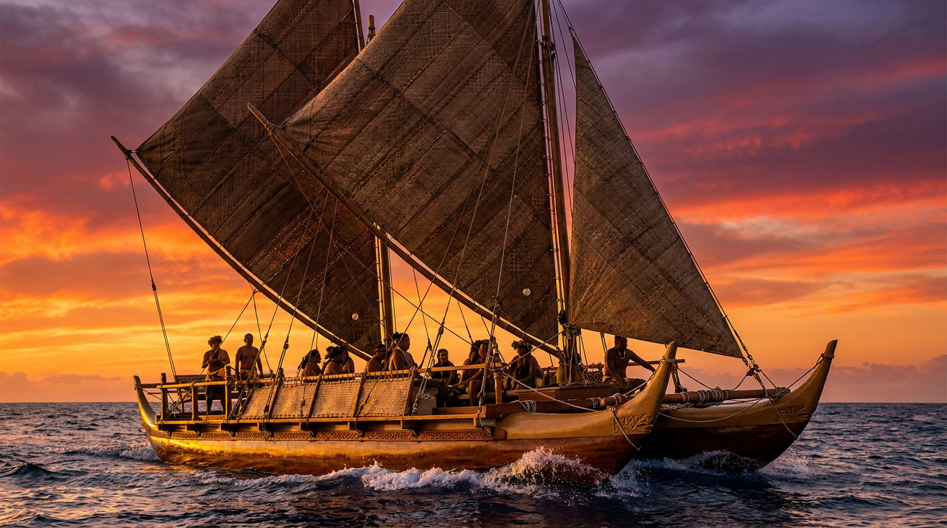
This ancient science was nearly lost to time and colonization. By the mid-20th century, traditional non-instrument navigation was practically extinct in Polynesia, surviving only in a few isolated pockets of Micronesia. The turning point came in the 1970s with the founding of the Polynesian Voyaging Society and the construction of the Hōkūleʻa, a 62-foot traditional double-hulled voyaging canoe built to test the limits of ancestral knowledge.[1][4]
To prove that intentional two-way voyaging was possible, the Hōkūleʻa needed a traditional navigator. The society recruited Mau Piailug, a master navigator from the Micronesian island of Satawal, who had learned the ancient arts from his father. In 1976, Mau successfully guided the Hōkūleʻa on a historic 2,500-mile journey from Hawaiʻi to Tahiti without a single modern instrument, sparking a cultural renaissance across the Pacific.[1][5]
The foundation of this navigational system is the "star compass." Unlike a physical compass, the Polynesian star compass is entirely a mental construct. The navigator divides the visual horizon into 32 distinct "houses," or segments, each positioned 11.25 degrees apart. By memorizing the exact points where specific stars rise out of the ocean in the east and set into the ocean in the west, the navigator creates a fixed grid over the sea.[1][2]

Master navigators like Mau Piailug memorized the paths of over 150 stars. Because celestial bodies move in parallel tracks across the sky, a star that rises in a specific house in the northeast will always set in the corresponding house in the northwest. By aligning the canoe with these rising and setting points, the wayfinder can maintain a precise heading throughout the night, using the sky as a rotating map.[1][4]
To determine their latitude, navigators use a technique known as "sailing down the latitude." They know which specific stars pass directly overhead—at the zenith—for their destination island. By observing the night sky, they can sail north or south until the destination's zenith star passes directly over the canoe's mast, indicating they have reached the correct latitude. From there, they simply turn and sail with the prevailing winds along that latitude until they strike land.[2][5]
From there, they simply turn and sail with the prevailing winds along that latitude until they strike land.
But the stars are only visible at night, and only when the sky is clear. During the day, or under heavy cloud cover, the navigator must rely on the ocean itself. The sun provides a rough bearing at dawn and dusk, but the primary daytime guide is the ocean swell, a constant and reliable force that shapes the movement of the vessel.[1][2]
Swells are different from surface wind waves; they are deep, rhythmic pulses of energy generated by distant storms, and they move in consistent directions for thousands of miles. A skilled wayfinder can feel the direction of up to four or five different swells simultaneously as they lift and pitch the hulls of the canoe. By noting the angle of the swells relative to the stars at night, the navigator can use those same swells to steer blindly during a cloudy day.[1][4]

As the canoe approaches its destination, the signs of land begin to multiply, long before the island itself crests the horizon. Islands disrupt the steady march of ocean swells, bending and reflecting the energy. A master navigator can read these interference patterns—the way a swell "bounces" back from an unseen landmass—to pinpoint an island's location, feeling the echo of the earth through the wood of the hull.[2][4]
Biology also provides a map. Wayfinders closely observe the behavior of seabirds, particularly the white tern and the noddy tern. These birds sleep on land but fly out to sea each morning to hunt for fish, returning to their home islands at dusk. If a navigator spots a flock of terns flying purposefully in the late afternoon, they simply follow the birds home.[2][4]
Even the clouds and the color of the sky offer clues. High volcanic islands force warm, moist air upward, creating stationary cloud formations that hover over the land while the rest of the sky moves with the wind. Over shallow coral atolls, the bright white sand and turquoise water reflect sunlight upward, painting the undersides of the clouds with a distinct greenish tint that can be seen from miles away.[2][4]

The physical and mental toll of wayfinding is immense. The navigator must stay awake for nearly the entire voyage, sometimes for weeks at a time, constantly observing the environment and maintaining a continuous mental log of the canoe's speed, heading, and drift—a process known as dead reckoning. There are no days off; a single missed shift in the wind or an unnoticed current can throw the vessel miles off course.[1][5]
Today, the art of wayfinding is no longer in danger of disappearing. Nainoa Thompson, who studied under Mau Piailug, became the first modern Native Hawaiian to navigate a canoe to Tahiti, and he has since trained a new generation of wayfinders from across the Pacific. The Hōkūleʻa has now sailed over 150,000 nautical miles, including a multi-year circumnavigation of the globe, proving the resilience of this ancestral knowledge.[1][3]

The revival of Polynesian navigation is more than just the recovery of a lost science; it is a profound testament to human ingenuity. As NASA astronaut Charles Lacy Veach once noted while comparing the Space Shuttle to the Hōkūleʻa, both are ultimate vessels of exploration. The voyaging canoe represents a time when humanity's highest technological achievement was not built of metal and code, but of wood, fiber, and an unbroken connection to the rhythms of the natural world.[3][5]
How we got here
300–800 CE
Polynesian explorers successfully navigate and settle the Hawaiian Islands using traditional wayfinding techniques.
1973
The Polynesian Voyaging Society is founded to revive the lost art of non-instrument navigation.
1976
The Hōkūleʻa completes a historic 2,500-mile voyage from Hawaiʻi to Tahiti, guided entirely by master navigator Mau Piailug without instruments.
2013–2017
The Hōkūleʻa completes the Mālama Honua Worldwide Voyage, circumnavigating the globe using traditional wayfinding.
Viewpoints in depth
Traditional Wayfinders
View navigation as a holistic, spiritual relationship with the natural world and ancestral lineage.
For traditional practitioners, wayfinding is not merely a set of technical skills or meteorological observations; it is a deeply spiritual discipline. The navigator is taught to view the canoe not as moving across the ocean, but as remaining stationary while the ocean and stars move around it. This perspective requires a profound humility and a continuous, unbroken dialogue with the environment, where the ancestors' knowledge is kept alive through oral tradition and physical practice.
Anthropologists & Historians
Focus on the evidence of intentional, sophisticated migration that debunked Western assumptions of accidental drift.
For decades, Western academia largely dismissed the idea that ancient peoples could intentionally navigate the vast Pacific, arguing that the islands were populated by castaways blown off course. Historians and anthropologists now point to the revival of wayfinding, alongside linguistic and genetic evidence, as definitive proof of the intentional settlement models. The ability to launch two-way voyages across thousands of miles demonstrates a highly organized maritime society with advanced technological capabilities.
Modern Navigators & Scientists
Analyze the cognitive and physical mechanics of traditional methods, comparing them to modern aerospace engineering.
Scientists and modern aerospace professionals view the traditional wayfinder as a human supercomputer. The cognitive load required to maintain a continuous mental log of speed, heading, drift, and celestial mechanics over weeks at sea is staggering. Organizations like NASA have studied the logistics of the Hōkūleʻa voyages, noting that the redundancy, risk assessment, and resource management required for a successful canoe voyage closely mirror the protocols required for long-duration human spaceflight.
What we don't know
- The exact timeline and specific routes of the earliest Polynesian migrations remain a subject of ongoing archaeological debate.
- How much of the original, pre-contact navigational knowledge was permanently lost before the 20th-century revival began.
Key terms
- Wayfinding
- The traditional art of navigating the open ocean without modern instruments, using natural signs like stars, swells, and birds.
- Star Compass
- A mental map used by navigators that divides the horizon into 32 houses to track the rising and setting of stars.
- Zenith Star
- A star that passes directly overhead a specific latitude, used by navigators to determine when they have reached the latitude of their destination.
- Ocean Swell
- Deep, rhythmic pulses of energy generated by distant storms that move in consistent directions, distinct from surface wind waves.
- Dead Reckoning
- The continuous mental calculation of a vessel's current position based on its previously known position, speed, heading, and drift.
Frequently asked
How did Polynesians navigate when it was cloudy?
When stars were obscured, navigators relied on the ocean swells, feeling the direction of the deep-water waves through the hull of the canoe to maintain their bearing.
What is a star compass?
It is a mental construct, not a physical tool. It divides the horizon into 32 segments based on where specific stars rise out of the ocean and set into it.
How did they know they were getting close to land?
Navigators looked for changes in wave patterns, stationary cloud formations, green reflections on cloud undersides, and the daily flight paths of specific seabirds.
What is the Hōkūleʻa?
It is a 62-foot replica of a traditional Hawaiian double-hulled voyaging canoe, built in the 1970s to prove that ancient Polynesians could intentionally navigate the Pacific.
Sources
Source coverage
5 outlets
3 viewpoints surfaced


[1]Polynesian Voyaging SocietyTraditional Wayfinders
Modern Methods and Techniques of Non‑Instrument Navigation
Read on Polynesian Voyaging Society →[2]WikipediaAnthropologists & Historians
Polynesian navigation
Read on Wikipedia →[3]NASAModern Navigators & Scientists
Similarities and Differences Between Canoe and Space Travel
Read on NASA →[4]FiveableAnthropologists & Historians
Ancient Polynesian Navigation Techniques
Read on Fiveable →[5]Factlen Editorial TeamModern Navigators & Scientists
Synthesis by Factlen editorial team
Read on Factlen Editorial Team →

Every angle. Every day.
Get culture stories with full source coverage and perspective breakdowns delivered to your inbox.