El Niño Returns to a 'Thermally Saturated' Ocean, Challenging Climate Models
NOAA and the UK Met Office have officially declared the onset of El Niño, warning of a potentially record-breaking event. However, new research suggests that because global oceans are already at record baseline temperatures, the weather phenomenon may behave in entirely unprecedented ways.
By Factlen Editorial Team
- Traditional Forecasters
- Predicting severe weather impacts based on absolute ocean temperature anomalies.
- Oceanic Modelers
- Arguing that thermal saturation will dampen the relative atmospheric response.
- Editorial Synthesis
- Evaluating the unprecedented nature of an El Niño in a record-hot baseline climate.
What's not represented
- · Agricultural Commodity Traders
- · Vulnerable Coastal Communities
- · Disaster Relief Organizations
Why this matters
El Niño dictates global weather patterns, driving severe droughts in Australia and Asia while fueling extreme precipitation in the Americas. If 'thermal saturation' alters how these events unfold, billions of dollars in agricultural forecasts and disaster preparedness plans may be relying on obsolete models.
Key points
- NOAA and the UK Met Office have officially declared the onset of El Niño conditions for 2026.
- Absolute ocean temperatures rival the record-breaking 1997-1998 event, prompting warnings of severe global weather impacts.
- New research suggests the global ocean is 'thermally saturated,' meaning the baseline temperature is already at record highs.
- This saturation weakens the relative temperature contrast needed to drive classic El Niño weather patterns like the Walker Circulation.
- A divergence between absolute and relative metrics has created massive uncertainty for climate modelers and agricultural planners.
- Regardless of weather impacts, the heat released by the Pacific is expected to push global average temperatures to new extremes.
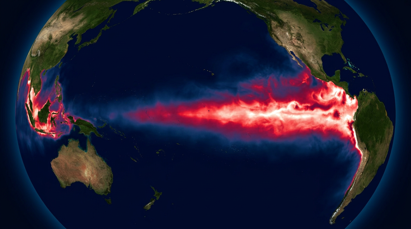
The global climate system has officially crossed a threshold. In June 2026, the US National Oceanic and Atmospheric Administration (NOAA), the UK Met Office, and the World Meteorological Organization formally declared the onset of El Niño conditions in the tropical Pacific. This transition, anticipated for months, marks the beginning of a profound shift in global weather patterns, driven by a massive pool of unusually warm water rising to the ocean's surface.[2][3][5]
The absolute metrics currently being recorded are staggering. According to NOAA's Climate Prediction Center, subsurface upper-ocean heat in the equatorial East Pacific is now rivaling the legendary 1997-1998 El Niño, an event that caused billions of dollars in global weather-related damage. Forecasters have placed a 63 percent probability on this event intensifying into a 'very strong' El Niño by the Northern Hemisphere winter, a status defined by sea surface temperature anomalies exceeding 2.0 degrees Celsius above the historical average.[2][4]
The implications of an event of this magnitude are typically severe and far-reaching. Professor Adam Scaife, Head of Long-Range Forecasting at the Met Office, warned that the developing system has the potential to bring severe impacts to multiple regions worldwide. Furthermore, the sheer volume of residual heat being vented from the Pacific into the atmosphere is highly likely to cause a temporary but sharp spike in global annual temperatures, potentially making 2027 the hottest year in the instrumental record.[3][5]
However, a critical complication is emerging within the scientific community: the ocean of 2026 is fundamentally different from the ocean of 1997. Decades of accelerating climate change have raised the baseline temperature of the entire global ocean to unprecedented levels. We are no longer observing an isolated patch of warm water in an otherwise cool sea; we are watching an El Niño attempt to form in an ocean that is already boiling.[6]
This unprecedented state of affairs is the focus of a new paper published in the journal Nature, which examines the dynamics of El Niño in a 'thermally saturated world.' The research highlights a growing disconnect between the absolute heat contained in the Pacific and the way the atmosphere might actually respond to it, challenging the core assumptions built into standard climate models.[1][6]
To understand this disconnect, one must look at the mechanics of the El Niño-Southern Oscillation (ENSO). The global weather impacts of El Niño are not caused directly by the warm water itself, but by how that warm water alters the atmosphere above it. Specifically, it disrupts the Walker Circulation—a massive east-to-west airflow driven by the temperature and pressure differences between the normally warm western Pacific and the normally cool eastern Pacific.[2][6]

To understand this disconnect, one must look at the mechanics of the El Niño-Southern Oscillation (ENSO).
In a thermally saturated world, this crucial temperature gradient is severely compromised. Because the western Pacific, the Atlantic, and the Indian Oceans are also experiencing record-high baseline temperatures, the localized warming of the eastern Pacific during this El Niño does not create the stark contrast it once did. Without that sharp contrast, the atmospheric engine that drives global weather shifts may struggle to start.[1][6]
This theoretical problem has manifested in a sharp divergence between different meteorological measurements. Traditional forecasting relies heavily on the Niño 3.4 index, which measures absolute sea surface temperature anomalies in a specific equatorial box. By this traditional metric, the ocean shifted into a powerful El Niño state months ago, and dynamic models are flashing red.[4]
Conversely, a newer metric called the Relative Oceanic Niño Index (RONI) paints a vastly different picture. RONI is designed to eliminate the background noise of accelerating global oceanic warming, measuring the El Niño anomaly relative to the rest of the world's oceans. While the traditional index shows a massive spike, recent RONI values have hovered near neutral, suggesting that the relative strength of this El Niño is actually quite weak.[4]

This divergence creates a nightmare scenario for climate modelers and risk managers. If the atmosphere responds to the absolute heat—as traditional models predict—the world will face a catastrophic compounding of extremes. The classic El Niño playbook would bring devastating droughts to Australia, Indonesia, and India, while unleashing torrential rains and flooding across the southern United States and equatorial South America.[2][3][6]
But if the atmosphere responds primarily to the relative gradient—as the RONI metric and the 'thermal saturation' hypothesis suggest—the weather impacts could be surprisingly muted. We could witness a 'phantom' El Niño: an event that registers as historically massive in the ocean but fails to fully couple with the atmosphere, leaving global precipitation patterns largely unchanged.[1][4][6]
Even a phantom El Niño, however, offers no reprieve from the broader climate crisis. Whether or not the Walker Circulation breaks down to cause regional droughts and floods, the physical heat from the Pacific will still transfer into the global atmosphere. The thermal saturation of the oceans means that they are losing their capacity to buffer human-caused warming, accelerating the rise in global surface temperatures regardless of wind patterns.[1][3][6]

For agricultural planners, commodity markets, and disaster response agencies, the next six months represent a period of profound vulnerability. Billions of dollars in crop yield forecasts and emergency preparedness budgets are currently balanced on the edge of this meteorological uncertainty. Preparing for a record-breaking traditional El Niño is vastly different from preparing for a globally saturated heat event with muted regional dynamics.[6]
Ultimately, the winter of 2026-2027 will serve as a real-time, high-stakes stress test for our fundamental understanding of ocean-atmosphere dynamics. As the Pacific continues to warm, it will reveal whether our 20th-century climate models can still accurately predict the behavior of a 21st-century thermally saturated world.[1][6]
How we got here
1997-1998
A record-breaking El Niño event sets the modern benchmark for extreme oceanic heat and global weather disruption.
Early 2026
Subsurface ocean heat in the equatorial Pacific begins to build rapidly, rivaling 1997 levels.
June 2026
NOAA and the UK Met Office officially declare the onset of El Niño conditions.
Winter 2026-27
The projected peak of the current El Niño, with a 63% probability of reaching 'very strong' status.
Viewpoints in depth
Traditional Forecasters
Focusing on absolute temperature anomalies to predict severe global impacts.
Agencies like NOAA and the Met Office rely heavily on absolute sea surface temperature anomalies in the Niño 3.4 region. Because these absolute temperatures are currently rivaling the strongest events on record, these forecasters warn that we should prepare for catastrophic weather shifts, arguing that the sheer volume of heat cannot be ignored by the atmosphere.
Oceanic Modelers
Emphasizing relative indices and the dampening effect of a thermally saturated ocean.
Researchers utilizing the Relative Oceanic Niño Index (RONI) argue that absolute heat matters less than the temperature contrast between different ocean regions. Because the global ocean baseline is so high, they suggest the atmospheric response (the Walker Circulation) might be significantly weaker than traditional models predict, leading to an oceanic El Niño that fails to trigger the expected global weather extremes.
Global Risk Managers
Preparing for compounded extremes regardless of the exact atmospheric coupling.
For agricultural planners and disaster response agencies, the academic debate over relative versus absolute indices is secondary to the baseline risk. They operate on the assumption that even a 'muted' El Niño, when superimposed on a thermally saturated, record-hot planet, will push local ecosystems and crop yields past their breaking points.
What we don't know
- Whether the atmosphere will fully couple with the ocean's absolute heat, or if the lack of a relative temperature gradient will mute the weather impacts.
- Exactly how much the residual heat from this El Niño will push up global average surface temperatures in 2027.
- How accurately current agricultural and economic models can forecast crop yields under these unprecedented 'thermally saturated' conditions.
Key terms
- El Niño-Southern Oscillation (ENSO)
- The cycle of warm and cold sea surface temperatures in the tropical Pacific Ocean that affects global weather.
- Walker Circulation
- An east-west atmospheric circulation pattern across the tropical Pacific, driven by temperature differences between the ocean's eastern and western regions.
- Niño 3.4 Index
- The traditional metric used to classify El Niño events, based on absolute sea surface temperature anomalies in a specific region of the central Pacific.
- Relative Oceanic Niño Index (RONI)
- A newer metric that measures El Niño strength relative to the warming of the rest of the global oceans, rather than using a fixed historical baseline.
Frequently asked
What is El Niño?
A climate pattern characterized by the warming of surface waters in the eastern tropical Pacific, which significantly alters global weather patterns.
What does 'thermally saturated' mean?
It refers to a state where the global ocean's baseline temperature is already so high that the localized warming of an El Niño creates less of a contrast than it did in the past.
Will this El Niño be the strongest on record?
In absolute temperature terms, it has a 63% chance of being 'very strong' and rivaling records. However, its actual weather impacts remain highly uncertain due to the globally warm oceans.
How does this affect global temperatures?
The heat released by the Pacific Ocean during an El Niño typically causes a temporary spike in global average temperatures, likely making 2026 or 2027 the hottest year on record.
Sources
Source coverage
6 outlets
3 viewpoints surfaced


[1]NatureOceanic Modelers
El Niño in a thermally saturated world
Read on Nature →[2]NOAA Climate Prediction CenterTraditional Forecasters
ENSO Diagnostic Discussion: June 2026
Read on NOAA Climate Prediction Center →[3]UK Met OfficeTraditional Forecasters
El Niño conditions develop in the tropical Pacific
Read on UK Met Office →[4]Climate Impact CompanyOceanic Modelers
NOAA announces presence of El Nino conditions: Possible record strength oceanic El Nino in 2026
Read on Climate Impact Company →[5]World Meteorological OrganizationTraditional Forecasters
WMO Update: Prepare for El Niño impacts
Read on World Meteorological Organization →[6]Factlen Editorial TeamEditorial Synthesis
Synthesis by Factlen editorial team
Read on Factlen Editorial Team →

Every angle. Every day.
Get science stories with full source coverage and perspective breakdowns delivered to your inbox.