Carnegie Mellon and Meta Partner to Build AI Tools for Emergency Response
A new collaboration leverages open-source AI and real-time mobility data to help first responders track population movements during natural disasters.
By Factlen Editorial Team
- Emergency Management Agencies
- Focuses on the practical, life-saving utility of real-time data during chaotic natural disasters.
- Open-Source AI Advocates
- Views the initiative as proof that open-weight models can drive profound public good beyond commercial applications.
- Global Sustainability Advocates
- Focuses on the broader implications of open-source AI for achieving sustainable development goals and equitable disaster relief.
What's not represented
- · Local residents in disaster-prone areas whose data is being aggregated.
- · First responders on the ground who will be testing the UI/UX of the new tools.
Why this matters
During a natural disaster, the difference between life and death often comes down to how quickly responders can locate stranded populations. By turning raw mobility data into real-time, AI-powered maps, this technology could fundamentally upgrade how governments manage evacuations and deploy rescue teams.
Key points
- Carnegie Mellon University and Meta have partnered to build AI-powered tools for emergency responders.
- The system uses aggregated mobility data and satellite imagery to track population movements during natural disasters.
- Meta's open-source AI models, including Segment Anything and DINO, will process the data into actionable situation reports.
- The tools aim to help agencies monitor evacuation compliance and locate stranded populations in real-time.
- Active testing of the system will take place alongside local emergency management agencies during the 2026 disaster season.
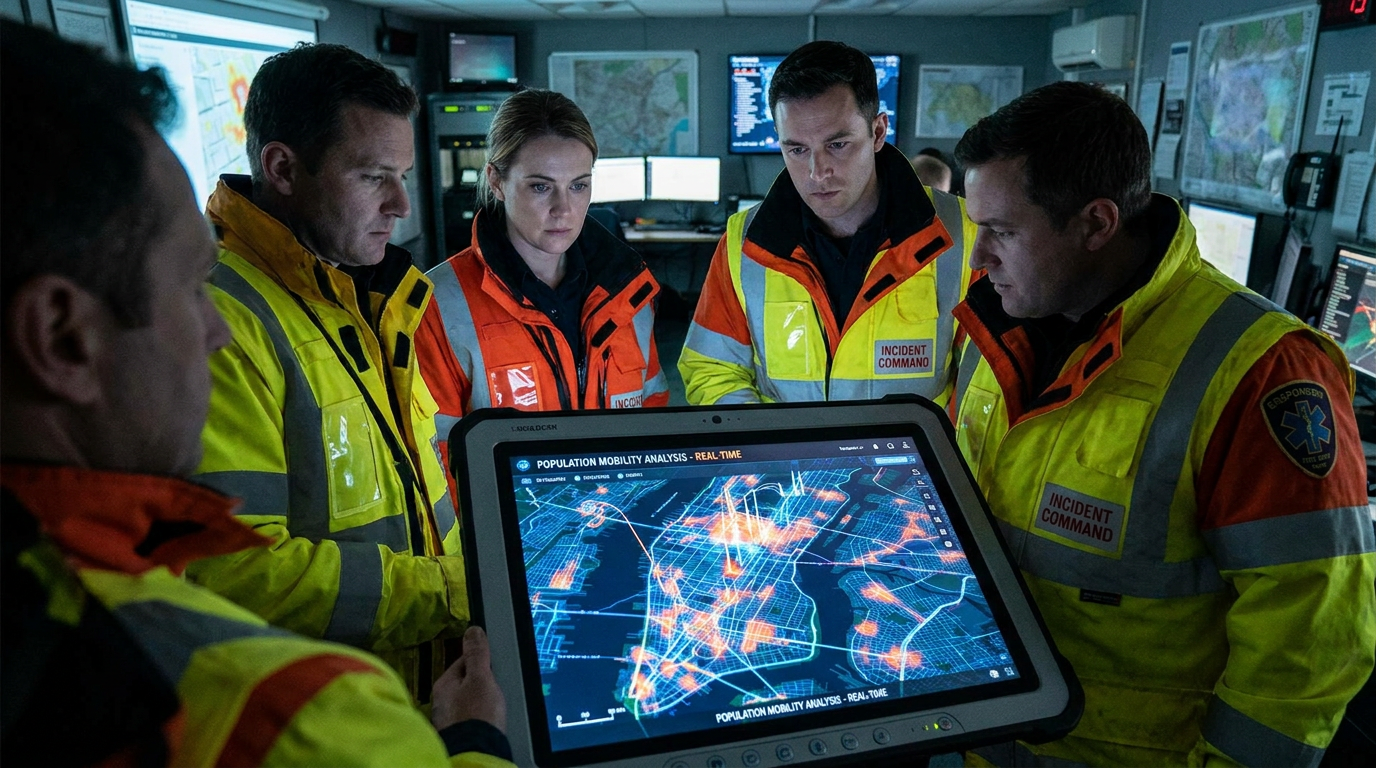
When a wildfire rapidly changes direction or a hurricane makes landfall, emergency managers face a critical information gap: they often do not know exactly where people are. Evacuation orders are issued, but tracking compliance and identifying stranded populations in real-time has historically relied on fragmented reports and manual surveys. To solve this, Carnegie Mellon University’s National Science Foundation AI Institute for Societal Decision Making (NSF AI-SDM) has announced a major partnership with Meta’s AI for Good program. The initiative, unveiled in mid-June 2026, aims to develop dynamic, AI-driven situation reports that provide first responders with unprecedented visibility into population mobility during natural disasters.[1][2]
The collaboration represents a significant shift in how academic institutions and major technology companies are deploying artificial intelligence for public safety. Rather than building entirely new surveillance networks, the project leverages aggregated, anonymized mobility and connectivity data that Meta already collects. By funneling this massive stream of real-time data through advanced analytical frameworks, researchers intend to create clear, simple visualizations that emergency managers can read at a glance. This allows incident commanders to make faster, more accurate decisions about where to deploy search-and-rescue teams, route supply convoys, or issue secondary evacuation warnings.[1][2][6]
At the technical core of the initiative is the integration of multimodal data streams with state-of-the-art open-source artificial intelligence. The CMU research team will fuse Meta’s mobility data with high-resolution satellite imagery, processing the combined feeds through Meta’s open-source vision models, including Segment Anything and DINO. These advanced computer vision models are capable of instantly identifying and isolating specific elements within complex images—such as flooded neighborhoods, blocked arterial roads, or structurally compromised bridges—without requiring extensive manual labeling or prior training on the specific geographic area.[1][3]

Alongside these vision models, the system will utilize large language models to synthesize the raw visual and mobility data into actionable, plain-language situation reports. For a first responder operating under extreme cognitive load, raw data is often less useful than a synthesized summary. The language models will act as an interpretive layer, translating complex geospatial anomalies into direct alerts, such as noting that a specific neighborhood has not yet evacuated despite rising floodwaters, or that a primary evacuation route is heavily congested and an alternative must be broadcast.[2][3][6]
The practical applications of this technology address some of the most persistent challenges in disaster management. Historically, determining whether a community has complied with an evacuation order has been a dangerous and time-consuming process, often requiring police or fire personnel to go door-to-door in hazardous conditions. With the new AI tools, emergency operations centers will be able to monitor population density shifts in real-time, instantly identifying pockets of people who remain in the danger zone. Furthermore, the tools will track when communities begin returning to affected areas following a disaster, helping agencies coordinate the restoration of power, water, and emergency medical services.[1][2]
The practical applications of this technology address some of the most persistent challenges in disaster management.
Leadership from both Carnegie Mellon and Meta have emphasized the life-saving potential of bridging the gap between frontier AI research and on-the-ground logistics. Rebecca Nugent, head of CMU’s Department of Statistics and Data Science, highlighted the initiative as a prime example of how academic-industry partnerships can drive profound social good. By combining CMU’s expertise in societal decision-making with Meta’s computational resources and data infrastructure, the project aims to fundamentally upgrade the technological arsenal available to local governments and nonprofits during extreme weather events.[2]

Laura McGorman, director of Meta AI for Good, echoed this sentiment, noting that leveraging real-time mobility data alongside artificial intelligence has the potential to completely transform disaster response. The initiative also aligns with the broader mission of the NSF AI-SDM, which was established to bring together artificial intelligence experts and social scientists. The institute focuses heavily on understanding human behavior during crises—specifically examining how people perceive risk, who they trust for information, and how resource-constrained environments shape their split-second decisions to flee or shelter in place.[1][4]
This partnership emerges against a backdrop of growing recognition regarding the role of open-source AI in addressing global challenges. A recent comprehensive study published in Nature Communications emphasized that open-source artificial intelligence is rapidly becoming a critical mechanism for accelerating the United Nations' Sustainable Development Goals. The researchers argued that making powerful AI models freely available enables more inclusive, evidence-based decision-making, shifting sustainability and crisis governance away from rigid, top-down systems toward highly responsive, participatory approaches that benefit from global scientific collaboration.[5][6]

Moving from theory to practice, the CMU and Meta project is operating on an aggressive timeline. The research team plans to actively evaluate these new AI tools during the 2026 natural disaster season, which includes the peak months for North American wildfires and Atlantic hurricanes. By testing the systems in live, high-stakes environments, the developers aim to determine which specific visualizations and data combinations are most effective for emergency managers working under pressure.[1][2]
To ensure the tools meet the actual needs of first responders, the NSF AI-SDM is collaborating directly with several state and local emergency management agencies. These agencies will provide continuous feedback on the system's utility, accuracy, and ease of use. Ultimately, the goal is to refine these experimental models into robust, automated data platforms that can be deployed globally, ensuring that when the next major disaster strikes, responders have the precise intelligence they need to save lives.[1][4][6]
How we got here
2023
The National Science Foundation establishes the AI Institute for Societal Decision Making (AI-SDM) at Carnegie Mellon University.
April 2023
Meta releases the Segment Anything Model (SAM), open-sourcing a major breakthrough in computer vision.
June 2026
CMU and Meta officially announce their partnership to build AI tools for emergency response.
Summer/Fall 2026
The newly developed AI tools enter active evaluation during the peak natural disaster season.
Viewpoints in depth
Emergency Management Agencies
Focuses on the practical, life-saving utility of real-time data during chaotic natural disasters.
For state and local emergency managers, the primary value of the CMU-Meta partnership lies in cutting through the fog of war that descends during a crisis. Historically, incident commanders have had to rely on delayed reports, 911 call clusters, and dangerous manual reconnaissance to understand where people are trapped. By providing a real-time, AI-synthesized dashboard of population mobility, these agencies argue they can deploy limited search-and-rescue resources far more efficiently, potentially saving lives that would otherwise be lost to logistical delays.
Open-Source AI Advocates
Views the initiative as proof that open-weight models can drive profound public good beyond commercial applications.
Technologists and researchers championing open-source AI point to this collaboration as a definitive success story for their movement. By utilizing freely available models like Segment Anything and DINO, the project demonstrates that frontier-tier computer vision capabilities do not need to be locked behind expensive, proprietary APIs. This camp argues that open-sourcing such powerful tools allows academic institutions like CMU to rapidly build and deploy bespoke solutions for public safety, accelerating innovation in sectors that typically lack massive research and development budgets.
Privacy & Data Ethicists
Emphasizes the critical need to balance life-saving mobility tracking with strict anonymization protocols.
While broadly supportive of using technology for disaster relief, data ethicists maintain a watchful eye on how mobility data is aggregated and utilized. This perspective stresses that even in emergencies, the tracking of civilian movements must rely strictly on anonymized, macro-level data rather than individual surveillance. They advocate for transparent data governance frameworks, ensuring that the systems built to monitor evacuation compliance during a hurricane are not subsequently repurposed for unwarranted tracking during non-emergencies.
What we don't know
- How effectively the AI models will perform in real-time under the chaotic, low-bandwidth conditions typical of a severe natural disaster.
- Which specific state and local emergency management agencies will be the first to fully integrate these tools into their standard operating procedures.
Key terms
- Segment Anything
- An open-source computer vision model developed by Meta that can identify and isolate specific objects within an image without prior training.
- DINO
- A self-supervised vision transformer model capable of understanding complex visual features and structures in images, such as satellite feeds.
- Large Language Model (LLM)
- An artificial intelligence system trained on vast amounts of text, used here to synthesize complex data into plain-language situation reports.
- Aggregated Mobility Data
- Anonymized location and connectivity information collected from large groups of devices, used to track broad population movements without identifying individuals.
Frequently asked
What is the goal of the CMU and Meta partnership?
The partnership aims to develop AI-driven dynamic situation reports that help first responders track population mobility and make faster decisions during natural disasters.
Which AI models are being used in this project?
The research team is utilizing Meta's open-source models, including the computer vision models Segment Anything and DINO, alongside large language models.
How does the system track population movements?
It analyzes aggregated, anonymized mobility and connectivity data provided by Meta's AI for Good program, combining it with satellite imagery to map where people are.
When will these AI tools be deployed?
The tools will undergo active evaluation and testing during the 2026 natural disaster season in collaboration with state and local emergency management agencies.
Sources
Source coverage
6 outlets
3 viewpoints surfaced


[1]Carnegie Mellon University NewsEmergency Management Agencies
Carnegie Mellon and Meta Partner To Develop AI Tools for Emergency Response
Read on Carnegie Mellon University News →[2]Dietrich College of Humanities and Social SciencesEmergency Management Agencies
Carnegie Mellon and Meta Partner to Develop AI Tools for Emergency Response
Read on Dietrich College of Humanities and Social Sciences →[3]Meta AI for GoodOpen-Source AI Advocates
Using Artificial Intelligence to Address Global Challenges
Read on Meta AI for Good →[4]National Science FoundationOpen-Source AI Advocates
AI Institute for Societal Decision Making (AI-SDM)
Read on National Science Foundation →[5]Nature CommunicationsGlobal Sustainability Advocates
Steering Open-Source AI to Accelerate the Sustainable Development Goals
Read on Nature Communications →[6]Factlen Editorial TeamGlobal Sustainability Advocates
Synthesis by Factlen editorial team
Read on Factlen Editorial Team →


Every angle. Every day.
Get ai stories with full source coverage and perspective breakdowns delivered to your inbox.