The Democratization of Intelligence: How Open-Source Analysts are Reshaping Global Security
The proliferation of commercial satellite imagery and digital forensics tools has empowered citizen journalists to rival state intelligence agencies. Open-Source Intelligence (OSINT) is transforming how the world tracks conflicts, environmental crimes, and human rights abuses.
By Factlen Editorial Team
- Open-Source Investigators
- Argue that radical transparency and public data empower citizens to hold powerful actors accountable and democratize truth.
- Defense & Security Analysts
- View OSINT as a highly valuable supplement to classified intelligence, crucial for battlefield transparency and strategic awareness.
- Privacy & Ethics Advocates
- Highlight the dual-use risks of open-source tools, warning that commercial surveillance can be weaponized against vulnerable individuals.
What's not represented
- · Commercial satellite providers balancing public access with national security requests.
- · Individuals whose privacy has been compromised by open-source tracking.
Why this matters
The ability to uncover global truths is no longer restricted to government spy agencies. The democratization of intelligence empowers ordinary citizens to track environmental crimes, verify human rights abuses, and hold powerful actors accountable using nothing more than a laptop and public data.
Key points
- Open-Source Intelligence (OSINT) allows citizen journalists to rival traditional state intelligence agencies.
- Commercial satellite imagery provides unprecedented battlefield transparency and environmental monitoring.
- Techniques like geolocation and chronolocation turn raw social media footage into verifiable evidence.
- The democratization of these tools raises new ethical questions regarding privacy and dual-use weaponization.
The era of exclusive state intelligence is over. For decades, the ability to monitor global events, track military movements, and uncover hidden truths was the sole domain of multi-billion-dollar government spy agencies. Today, a laptop and a broadband internet connection can rival the capabilities of Cold War-era intelligence apparatuses. The democratization of Open-Source Intelligence (OSINT) has fundamentally shifted the balance of information power, transferring investigative capabilities from classified state silos to citizen journalists, non-governmental organizations, and independent researchers. This transformation is not merely a technological shift; it is a revolution in global accountability, enabling ordinary citizens to verify contested events and hold powerful actors responsible in near-real time.[7]
At its core, OSINT is the practice of collecting, evaluating, and analyzing publicly available information to answer specific intelligence questions. The RAND Corporation defines this modern iteration as "second-generation OSINT," which leverages the massive proliferation of digital data—from social media metadata and public corporate filings to commercial satellite imagery—and exploits it to validate actionable intelligence. Unlike traditional espionage, which relies on clandestine human sources or classified intercepts, OSINT operates entirely in the open. The evidence is accessible to anyone willing to look, fundamentally altering how truth is established in an era increasingly defined by misinformation.[1]
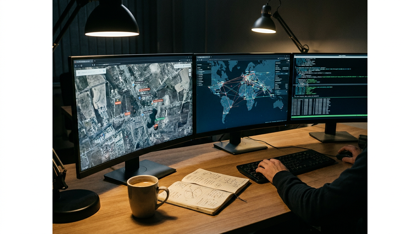
The most profound catalyst for this democratization has been the commercialization of space. The Center for Strategic and International Studies (CSIS) reports that the proliferation of commercial space assets has introduced an unprecedented era of "battlefield transparency." During the Cold War, the United States' CORONA project launched 145 highly classified satellite reconnaissance missions to map Soviet capabilities. Today, commercial companies like Planet Labs, Maxar, and Sentinel provide high-resolution optical and Synthetic Aperture Radar (SAR) imagery to anyone with a subscription—and often for free to researchers. This allows private OSINT companies and amateur analysts to assess military postures, track illegal fishing fleets, and counter state-sponsored disinformation with empirical, overhead proof.[2]

The pioneer and most prominent practitioner of this citizen-led intelligence model is Bellingcat. Founded in 2014 by Eliot Higgins, Bellingcat evolved from a solitary blog into an award-winning international collective of researchers and citizen journalists. By utilizing flight tracking data, social media triangulation, and open-source mapping tools like Google Earth, Bellingcat has successfully investigated some of the most complex geopolitical events of the last decade. Their work includes identifying the perpetrators behind the downing of Malaysia Airlines Flight 17 (MH17) over Ukraine and documenting the use of chemical weapons in Syria, proving that decentralized networks of volunteers can match, and sometimes exceed, the investigative rigor of state agencies.[3]
To understand the power of OSINT, one must look at its foundational techniques: geolocation and chronolocation. When a piece of user-generated content—such as a video of a military strike or a police crackdown—surfaces online, investigators do not take it at face value. Instead, they dissect the visual evidence. They match the ridgelines of distant mountains, the specific architectural features of buildings, or the layout of street signs against high-resolution satellite imagery on Google Earth to confirm the exact location. To verify the time, analysts examine the angle of shadows cast by buildings and cross-reference them with sun-position calculators, or check historical weather data to ensure the cloud cover matches the claimed date. This meticulous, scientific approach to digital forensics turns raw, unverified internet noise into irrefutable evidence.[3][7]
To understand the power of OSINT, one must look at its foundational techniques: geolocation and chronolocation.
The impact of organizations like Bellingcat has catalyzed a broader movement that academic researchers characterize as a new form of "digital citizenship" and data activism. A report from the Max Planck Institute highlights how open-source investigations have become consequential truth-production mechanisms that challenge traditional epistemic authorities. In the past, the public had to rely on the "trust us" assurances of classified government intelligence. Today, OSINT derives its epistemic authority from radical methodological transparency. Because the underlying data—a TikTok video, a ship's Automatic Identification System (AIS) ping, or a commercial satellite photo—is public, the investigative steps can be entirely reproduced and verified by third parties.[4]
This transparency has made OSINT an invaluable tool for human rights advocacy and international justice. Researchers routinely use publicly available data to document atrocities that would otherwise remain hidden behind closed borders. The RAND Corporation has detailed how analysts use nighttime lighting data to track the forced relocation of Rohingya refugees in Bangladesh, or analyze the construction of detention centers in Tibet. By combining geospatial intelligence with ground-level social media footage, investigators can chronolocate and geolocate events with pinpoint accuracy, building robust evidence packs that are increasingly accepted in international legal frameworks and human rights tribunals.[1]

Beyond conflict zones and human rights, OSINT has revolutionized environmental protection and climate accountability. Organizations like Global Fishing Watch utilize Automatic Identification System (AIS) data—originally designed to prevent ship collisions—and overlay it with commercial satellite imagery to track illegal, unreported, and unregulated fishing fleets across the globe. When ships "go dark" by turning off their transponders, analysts use Synthetic Aperture Radar (SAR), which can pierce through cloud cover and darkness, to locate the rogue vessels. Similarly, open-source researchers monitor real-time satellite feeds to detect illegal logging in the Amazon or unauthorized mining operations, providing environmental NGOs with the hard data needed to pressure governments and corporations into action.[2][7]
The integration of OSINT into mainstream media further validates its efficacy. Legacy news organizations, which initially viewed citizen investigators with skepticism, are now actively collaborating with the open-source community. Outlets like The New York Times and the BBC have established their own dedicated visual investigation desks, frequently partnering with independent OSINT analysts to verify footage from conflict zones or expose corruption. This collaborative ecosystem has raised the bar for investigative journalism, ensuring that high-impact stories are grounded in verifiable, open-source data rather than relying solely on anonymous sources or official government statements.[7]
Despite its empowering potential, the democratization of intelligence is accompanied by significant challenges, most notably the sheer volume of data and the risk of information overload. The World Customs Organization notes that the open nature of OSINT means analysts must constantly sift through oceans of misinformation, disinformation, and outdated material. The dynamic nature of the internet requires rigorous verification processes to ensure the credibility of sources. When amateur crowds attempt to crowdsource investigations without strict methodological standards, the results can be disastrous—as seen in the infamous misidentification of suspects by Reddit users following the Boston Marathon bombing.[5]

Furthermore, the tools that empower citizen journalists possess a fundamentally dual-use nature. The Centre for International Governance Innovation warns that the same semantic search engines, facial recognition software, and geospatial tracking tools used to expose human rights abuses can be weaponized by malicious actors. State intelligence services, criminal syndicates, and authoritarian regimes leverage these identical open-source tools to track dissidents, oppress activists, and conduct corporate espionage. The tension between open-source investigation and individual privacy remains a complex ethical frontier, as the mosaic of publicly available data can easily be assembled to strip away anonymity.[6]
Looking forward, the OSINT landscape is poised for another massive leap with the integration of artificial intelligence and machine learning. AI-powered change detection algorithms can now process the massive volume of satellite imagery collected daily, automatically flagging new construction, troop movements, or deforestation in near-real time. As these computational tools become more accessible, the speed and scale of open-source investigations will increase exponentially. While the ethical and security challenges are non-trivial, the democratization of intelligence ensures that the world is watching closer than ever before, making it increasingly difficult for powerful actors to operate in the shadows.[2][7]
How we got here
Cold War Era
Satellite reconnaissance and global intelligence gathering are exclusively controlled by heavily funded state agencies.
2005
Google Earth is launched, providing the general public with unprecedented access to high-resolution satellite imagery.
August 2013
Citizen journalists use open-source social media videos to document the Ghouta chemical attack in Syria.
July 2014
Bellingcat is founded, formalizing the citizen-led open-source investigation movement.
2022-Present
Commercial satellite imagery and OSINT play a pivotal role in providing real-time battlefield transparency during the war in Ukraine.
Viewpoints in depth
Open-Source Investigators
Advocates for radical transparency and the democratization of truth.
This camp, led by collectives like Bellingcat and academic researchers, argues that the monopoly on intelligence held by state agencies is obsolete. By leveraging publicly available data, they believe ordinary citizens can build irrefutable evidence packs that hold governments, corporations, and military forces accountable. Their epistemic authority relies entirely on showing their work, allowing anyone with an internet connection to re-trace their steps and verify their conclusions independently.
Defense & Security Analysts
Professionals integrating public data into strategic intelligence.
Traditional intelligence and defense organizations view OSINT as a critical, force-multiplying supplement to classified intelligence. They emphasize the strategic value of 'battlefield transparency' provided by commercial space assets, which allows for rapid attribution of military activity and the countering of state-sponsored disinformation. However, they also focus on the operational security risks, noting that adversaries have equal access to these powerful commercial tools.
Privacy & Ethics Advocates
Critics warning of the dual-use nature of digital tracking tools.
Privacy advocates caution that the tools empowering citizen journalists are fundamentally dual-use. The same facial recognition software, semantic search engines, and geospatial tracking data used to expose human rights abuses can be weaponized by authoritarian regimes or criminal syndicates to hunt dissidents and strip away individual anonymity. They argue for stronger ethical frameworks and regulations to prevent commercial surveillance from being exploited.
What we don't know
- How international legal frameworks will adapt to regulate the dual-use nature of commercial spyware and OSINT tools.
- The long-term impact of AI-generated deepfakes on the reliability of open-source visual evidence.
Key terms
- OSINT
- Open-Source Intelligence; actionable information derived from publicly available sources.
- Geolocation
- The process of identifying the real-world geographic location of an object or event shown in digital media.
- Chronolocation
- The technique of determining the exact time and date a photograph or video was captured using visual clues like shadows and weather.
- Synthetic Aperture Radar (SAR)
- A form of radar used to create two-dimensional images or three-dimensional reconstructions of landscapes, capable of piercing through clouds and darkness.
- Automatic Identification System (AIS)
- An automated tracking system used on ships to display their location, speed, and navigational status.
Frequently asked
What is Open-Source Intelligence (OSINT)?
OSINT is the practice of collecting, evaluating, and analyzing publicly available information—such as social media, satellite imagery, and public records—to generate actionable intelligence.
How do investigators verify online videos?
Analysts use techniques like geolocation (matching landmarks to satellite maps) and chronolocation (analyzing shadow angles and weather data) to confirm exactly where and when a video was recorded.
Can anyone do open-source investigation?
Yes. Because the underlying data and tools (like Google Earth) are publicly available, citizen journalists and independent researchers can conduct investigations, provided they follow rigorous verification methodologies.
What are the risks of OSINT?
The primary risks include information overload, the rapid spread of disinformation, and the potential for malicious actors to use the same tracking tools to violate individual privacy.
Sources
Source coverage
7 outlets
3 viewpoints surfaced


[1]RAND CorporationDefense & Security Analysts
Defining Second Generation Open Source Intelligence (OSINT) for the Defense Enterprise
Read on RAND Corporation →[2]Center for Strategic and International StudiesDefense & Security Analysts
Battlefield Transparency and the Proliferation of Commercial Space Assets
Read on Center for Strategic and International Studies →[3]BellingcatOpen-Source Investigators
Bellingcat: The Home of Online Investigations
Read on Bellingcat →[4]Max Planck InstituteOpen-Source Investigators
Open Source Investigations and Digital Citizenship in the Post-Truth Era
Read on Max Planck Institute →[5]World Customs OrganizationPrivacy & Ethics Advocates
Unlocking the Value of Open-Source Intelligence
Read on World Customs Organization →[6]Centre for International Governance InnovationPrivacy & Ethics Advocates
The Dual-Use Nature of Open-Source Intelligence Tools
Read on Centre for International Governance Innovation →[7]Factlen Editorial TeamOpen-Source Investigators
Synthesis by Factlen editorial team
Read on Factlen Editorial Team →
Every angle. Every day.
Get defense security stories with full source coverage and perspective breakdowns delivered to your inbox.