Mindanao Earthquake Death Toll Reaches 61 as Tectonic Shift Raises Seabed by Two Meters
A 7.8-magnitude earthquake in the southern Philippines has killed at least 61 people and triggered a massive coastal uplift, exposing coral reefs and extending the shoreline by up to 200 meters.
By Factlen Editorial Team
- Philippine Disaster Authorities
- Focuses on the immediate need for search and rescue, restoring critical infrastructure, and managing mass displacement.
- Geological & Environmental Experts
- Highlights the rare and destructive nature of the 2-meter coastal uplift and its ecological consequences.
- International Observers
- Focuses on the regional seismic impact, the initial tsunami threats, and the mobilization of foreign aid and monitoring.
What's not represented
- · Local Fishermen
- · Long-term Urban Planners
Why this matters
The magnitude 7.8 earthquake has not only caused massive loss of life and displaced hundreds of thousands, but it has fundamentally altered the geography of southern Mindanao. The violent coastal uplift has devastated local marine ecosystems and fishing livelihoods, compounding the humanitarian crisis with long-term ecological and economic damage.
Key points
- A 7.8-magnitude earthquake struck off the coast of Mindanao, killing at least 61 people.
- The seismic event caused a 'coastal uplift,' raising the seabed by up to two meters.
- Exposed coral reefs and seagrass beds are dying off, creating an immediate ecological crisis.
- Over 346,000 people have been affected, with 54,000 homes damaged or destroyed.
- Infrastructure damage has topped 1 billion pesos, complicating ongoing rescue efforts.
A massive 7.8-magnitude earthquake that struck the southern Philippines earlier this week has left at least 61 people dead and fundamentally altered the region's geography. The tremor, which hit off the coast of Mindanao on the morning of June 8, triggered widespread destruction, collapsing commercial buildings and triggering deadly landslides across multiple provinces. As search and rescue teams continue to comb through the rubble in hard-hit urban centers like General Santos City, authorities report that 40 people remain missing and over 1,400 have been injured. The sheer scale of the disaster has overwhelmed local emergency services, prompting a massive national response to reach communities cut off by severed roads and failing communication networks.[3][5]
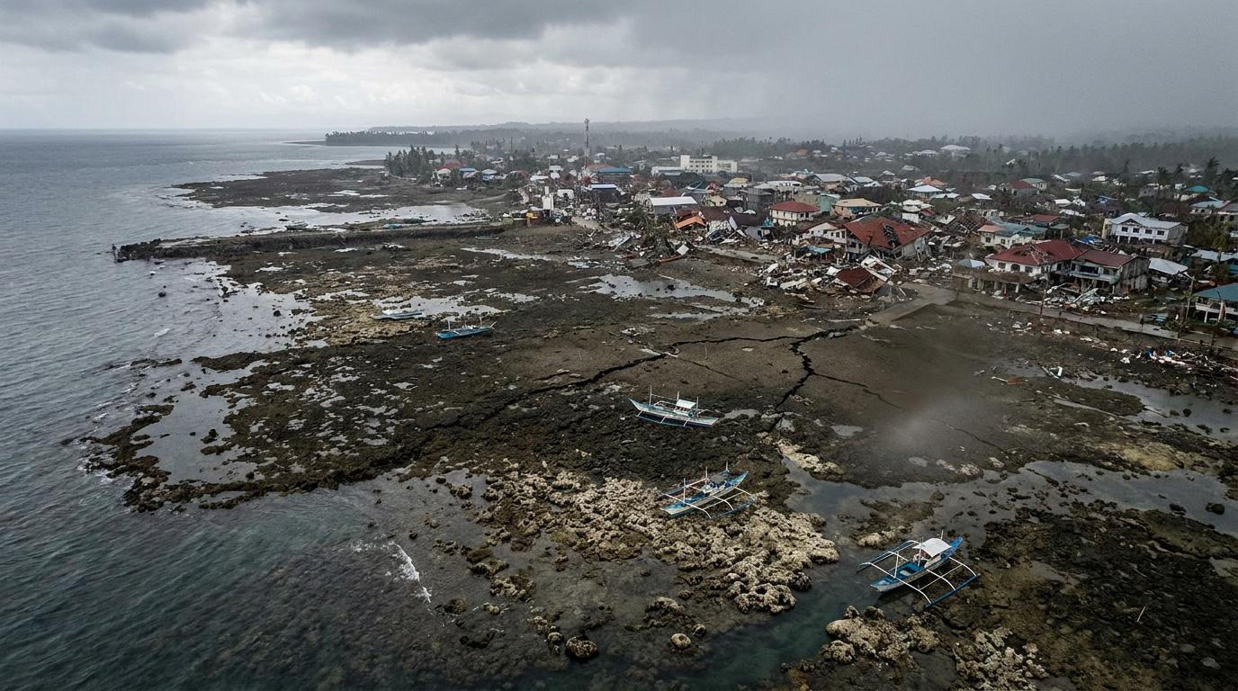
Beyond the immediate humanitarian toll, scientists and local residents are grappling with a startling geological phenomenon: the violent seismic shift pushed the ocean floor upward by as much as two meters (6.6 feet). This rare event, known as 'coastal uplift,' has permanently extended the shoreline by up to 200 meters in parts of Sarangani and Davao Occidental provinces. The immense tectonic force essentially thrust the submerged continental shelf into the open air, instantly redrawing the map of the southern Philippines and leaving coastal communities bewildered by the sudden disappearance of their traditional waters.[1][2]
The sudden exposure of the seabed has triggered an immediate and severe ecological crisis. Images released by the Philippine environment department show large swathes of newly exposed coral reefs and seagrass beds littered with dead fish, eels, clams, and other marine organisms. The die-off has been so rapid and extensive that local residents initially reported the changing shoreline out of fear they might be poisoned by the overwhelming fumes of decaying marine life. Environmental experts warn that the destruction of these foundational reef ecosystems will have cascading effects on local biodiversity, potentially taking decades to recover, if they can recover at all.[1][8]

The Philippine Institute of Volcanology and Seismology (PHIVOLCS) attributed the immense rupture to thrust faulting along the Cotabato Trench, a major undersea depression located just 50 kilometers off the coast of Mindanao. The trench is a known hotspot for seismic activity, having produced a swarm of smaller quakes earlier in the year. However, experts note this particular tremor released considerably more energy than recent events, making it the most powerful earthquake to strike the region since a devastating 8.1-magnitude quake whipped up deadly tsunami waves in August 1976. The shallow depth of the rupture, estimated at 33 kilometers, amplified the violent shaking felt on the surface.[2][4]
The trench is a known hotspot for seismic activity, having produced a swarm of smaller quakes earlier in the year.
The human displacement resulting from the quake is staggering. The National Disaster Risk Reduction and Management Council (NDRRMC) estimates that over 346,000 people have been directly affected across the Mindanao region. With more than 54,000 homes damaged or completely destroyed, tens of thousands of families are currently sheltering in crowded evacuation centers or sleeping in open spaces. Many are driven outdoors not just by the loss of their homes, but by the paralyzing fear of structural collapse amid nearly 3,000 recorded aftershocks, some registering as high as magnitude 6.4. The disruption to daily life is absolute, with schools, markets, and basic public services entirely suspended in the hardest-hit zones.[4][6]
Critical infrastructure across the region has suffered catastrophic failures, severely complicating the ongoing relief efforts. In the highly populated port hub of General Santos City, the intense shaking brought down commercial establishments, a university building, and a major grocery store where rescuers spent days painstakingly extracting victims from the concrete wreckage. The NDRRMC estimates that infrastructure losses have already topped 1 billion Philippine pesos (approximately $16.2 million). Vital bridges have collapsed, and major highways have been cracked wide open or blocked entirely by massive landslides, effectively isolating several rural municipalities from immediate state aid.[3][4]

Rescue operations have been severely hampered by these treacherous conditions. Emergency crews, bolstered by military personnel and international aid organizations, are battling persistent rain, unstable ruins, and severed road networks to reach isolated communities. In the mountainside town of Glan, a massive landslide buried dozens of homes and claimed at least 18 lives, further complicating retrieval efforts as heavy earth-moving equipment struggles to navigate the compromised terrain. For many families holding vigil at collapse sites, the agonizing wait often ends in grief, though the recovery of remains offers a painful but necessary closure amid the chaos.[1][5]
The earthquake's sheer power also triggered immediate regional panic, prompting tsunami warnings across the southern Philippines, Indonesia, Malaysia, and as far away as Japan. While a catastrophic basin-wide tsunami did not materialize, coastal towns like Kiamba recorded elevated waves reaching 1.4 meters. The alerts forced rapid, chaotic evacuations of low-lying areas following urgent bulletins from international monitors and foreign embassies. The swift evacuation likely saved countless lives, but the false alarm of a mega-tsunami added a layer of profound psychological trauma to a population already reeling from the violent shaking.[4][7]

As the Philippines transitions from the acute search-and-rescue phase into long-term recovery, the government faces an unprecedented dual crisis. Authorities must not only rebuild shattered cities, restore critical utilities, and rehouse hundreds of thousands of displaced residents, but they must also navigate the permanent economic damage to coastal communities. The sudden, violent redrawing of the shoreline has upended local fishing livelihoods, leaving fleets stranded and traditional fishing grounds destroyed. The recovery will require massive domestic investment and sustained international support to help Mindanao adapt to its newly altered geography.[1][4]
How we got here
June 8, 2026
A 7.8-magnitude earthquake strikes off the coast of Mindanao, triggering regional tsunami warnings.
June 9, 2026
Rescue operations intensify in General Santos City as widespread infrastructure collapse is confirmed.
June 10, 2026
Residents report a strange smell, leading to the discovery of exposed, dying coral reefs due to coastal uplift.
June 14, 2026
The death toll reaches 61, with authorities confirming the seabed was raised by up to two meters.
Viewpoints in depth
Philippine Disaster Authorities
Focuses on the immediate need for search and rescue, restoring critical infrastructure, and managing mass displacement.
For national and regional disaster management agencies, the primary focus remains the acute humanitarian crisis. With over 346,000 people affected and 54,000 homes damaged, authorities are prioritizing the distribution of food, water, and temporary shelter. They emphasize that the ongoing threat of landslides and nearly 3,000 aftershocks necessitates keeping populations in safe evacuation zones, even as they work to clear blocked highways and rebuild the 1 billion pesos worth of destroyed infrastructure.
Geological & Environmental Experts
Highlights the rare and destructive nature of the 2-meter coastal uplift and its ecological consequences.
Scientists and environmentalists are alarmed by the sheer scale of the geological transformation. The 2-meter coastal uplift is a rare event that has instantly wiped out vibrant, shallow-water ecosystems. Experts argue that the death of these coral reefs and seagrass beds will have a cascading effect on local marine biodiversity. They are calling for immediate ecological assessments to understand the long-term impacts on the region's coastal resilience and to determine if any of the exposed marine life can be salvaged or rehabilitated.
Affected Coastal Communities
Centers on the trauma of the sudden disaster, the loss of homes, and the destruction of local livelihoods.
For the residents of Mindanao, particularly in Sarangani and Davao Occidental, the earthquake is both a physical and economic tragedy. Beyond the terror of collapsing buildings and the grief of lost loved ones, coastal communities are facing the sudden erasure of their traditional fishing grounds. The newly exposed, decaying seabed has not only created a foul-smelling health hazard but has also stranded fishing boats and destroyed the local marine economy, leaving residents uncertain about how they will survive in a permanently altered landscape.
What we don't know
- The exact number of casualties, as 40 people remain missing under rubble and landslides.
- How long it will take for the exposed and dying coral reef ecosystems to recover, if recovery is even possible.
- The full extent of the economic damage to local fishing industries that rely on the now-altered coastline.
Key terms
- Cotabato Trench
- A major oceanic trench and fault line located off the southwestern coast of Mindanao, known for generating powerful earthquakes.
- Coastal Uplift
- A geological process where the land or seabed is elevated due to tectonic plate movement during an earthquake.
- Thrust Faulting
- A type of geological fault where one tectonic plate is pushed up and over another, often responsible for the most powerful earthquakes.
- PHIVOLCS
- The Philippine Institute of Volcanology and Seismology, the national agency responsible for monitoring earthquakes and tsunamis.
Frequently asked
What caused the earthquake in the Philippines?
The 7.8-magnitude earthquake was caused by a sudden shift along the Cotabato Trench, a major tectonic fault line located off the southern coast of Mindanao.
What is coastal uplift?
Coastal uplift is a geological phenomenon where tectonic forces push the ocean floor upward. In this quake, the seabed was raised by up to two meters, permanently extending the shoreline.
How many people were affected by the disaster?
Over 346,000 people have been affected, with at least 61 confirmed dead, 40 missing, and more than 54,000 homes damaged or destroyed.
Is there still a tsunami threat?
The initial tsunami warnings issued immediately after the quake have been lifted, though coastal areas did experience elevated waves of up to 1.4 meters during the event.
Sources
Source coverage
8 outlets
3 viewpoints surfaced


[1]The GuardianGeological & Environmental Experts
Deadly Philippines earthquake found to have raised seabed by up to 2 metres
Read on The Guardian →[2]ABS-CBN NewsGeological & Environmental Experts
Deadly Mindanao quake raised seabed by up to two meters
Read on ABS-CBN News →[3]XinhuaPhilippine Disaster Authorities
61 dead, 40 missing after strong quake in S. Philippines
Read on Xinhua →[4]ReliefWebPhilippine Disaster Authorities
Philippines: Earthquake - Jun 2026
Read on ReliefWeb →[5]Malay MailInternational Observers
Death toll rises to 61 in Mindanao quake, dozens remain missing
Read on Malay Mail →[6]PhilstarPhilippine Disaster Authorities
61 dead, 173,000 families affected in Mindanao quake — NDRRMC
Read on Philstar →[7]U.S. Embassy in the PhilippinesInternational Observers
Natural Disaster Alert: Magnitude 7.8 Earthquake, Tsunami Warning affecting Mindanao
Read on U.S. Embassy in the Philippines →[8]The HinduGeological & Environmental Experts
Philippines earthquake raised seabed by two metres, exposing coral
Read on The Hindu →
More in news politics
See all 6 stories →Supreme Court
Supreme Court Enters Final Stretch With 23 Cases That Could Reshape Executive Power
0 sources

US-Iran Deal
Israel Strikes Beirut as U.S. and Iran Near Potential Peace Deal
0 sources
Iran Diplomacy
US and Iran Near Mediated Security Framework Amid Regional Pushback
0 sources

EV Transition
UK to Water Down 2030 Electric Vehicle Sales Targets Amid Industry Pressure
0 sources

Every angle. Every day.
Get news politics stories with full source coverage and perspective breakdowns delivered to your inbox.