The Evidence Behind the Colorado River Crisis: Aridification and the Looming Legal Battle
As the 2026 deadline for new operating guidelines approaches, hydrologic data confirms the Colorado River faces permanent aridification, setting up a historic legal clash over water cuts.
By Factlen Editorial Team
- Scientific Consensus
- Hydrologists and climatologists emphasize that the river's decline is a permanent shift, not a temporary drought.
- Lower Basin States
- California, Arizona, and Nevada argue that cuts should be shared across the entire basin, including accounting for evaporation.
- Upper Basin States
- Colorado, Utah, New Mexico, and Wyoming argue they already bear the brunt of climate change and cannot release water they don't have.
- Federal Regulators
- The federal government seeks to broker a consensus but holds the authority to unilaterally impose cuts to protect the reservoirs.
What's not represented
- · Indigenous Tribes with unresolved water rights
- · Mexican agricultural sectors reliant on cross-border flows
Why this matters
The Colorado River sustains 40 million people and a $1.4 trillion agricultural economy. Failure to agree on water reductions will trigger federal intervention and potentially reshape the American Southwest's food supply and urban growth.
Key points
- The Colorado River is experiencing permanent, climate-driven aridification, with flows down 20% since 2000.
- A structural deficit exists because the system legally allocates and loses 1.5 million acre-feet more than it receives annually.
- The seven basin states face a critical 2026 deadline to agree on new operating guidelines and permanent water cuts.
- The Upper and Lower Basins are deadlocked over whether to account for evaporation losses and how to share the reductions.
- Agriculture uses roughly 80% of the river's water, making it the primary target for necessary, albeit economically painful, cuts.
The Colorado River Basin is approaching a critical and potentially explosive juncture. By the end of 2026, the interim guidelines governing the river's massive reservoir system will expire, forcing seven U.S. states to agree on a new framework for distributing a rapidly shrinking resource. With 40 million people across the Southwest and a $1.4 trillion agricultural economy entirely dependent on the river's flows, the stakes are genuinely existential. Tensions between state negotiators are rising rapidly as the deadline nears, with the prospect of unprecedented, multi-state litigation looming over the proceedings if a consensus cannot be reached. The era of temporary fixes has ended, replaced by the need for permanent, structural reductions.[1][4]
The central scientific claim driving the current crisis is that the Colorado River is no longer experiencing a temporary, cyclical drought, but rather a permanent state of aridification. Climate scientists and hydrologists argue that rising global temperatures have fundamentally and irreversibly altered the basin's water cycle. This shift means that even in years with average or above-average precipitation, the system yields significantly less runoff into the river. Hotter ambient temperatures increase evaporation rates from reservoirs and streams, while simultaneously drying out the soil, which acts like a sponge, absorbing snowmelt before it can ever reach the riverbed.[3][7]
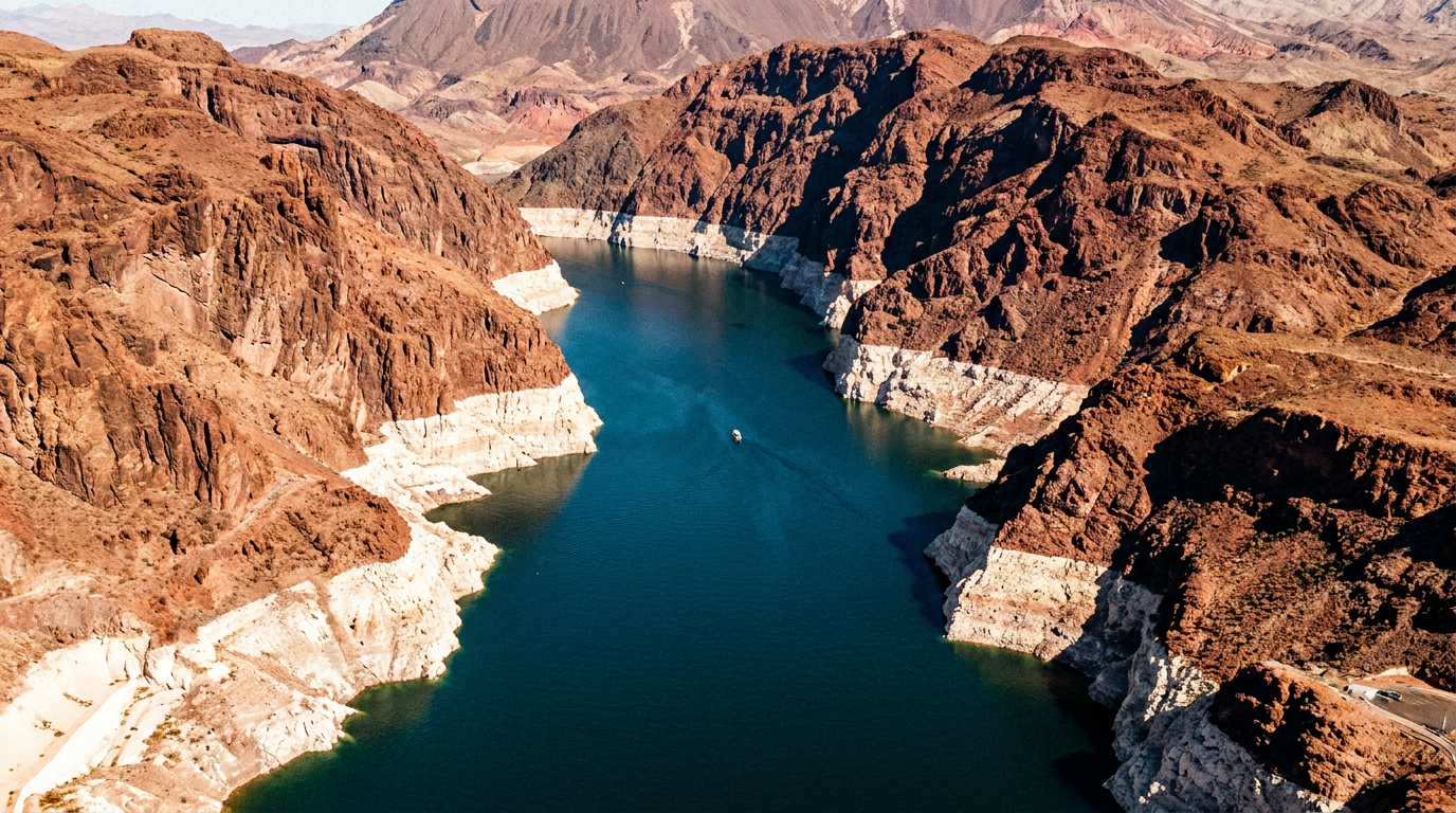
The evidence supporting this aridification claim is highly robust and widely accepted across the scientific community. Peer-reviewed hydrologic models and extensive data collected by the U.S. Geological Survey demonstrate a stark correlation: for every 1 degree Celsius of regional warming, the river's flow decreases by approximately 9 percent. The empirical results are already visible. Since the year 2000, the river's average annual flow has dropped by roughly 20 percent compared to the 20th-century average. Researchers emphasize that this decline is directly correlated with rising baseline temperatures rather than just a historic lack of rain or snow.[3][4][7]
Compounding the climate-driven decline is a well-documented 'structural deficit' in how the river is legally managed. The U.S. Bureau of Reclamation's hydrologic models confirm that the system legally allocates and physically loses about 1.5 million acre-feet more water annually than it takes in, even in normal years. This structural deficit is the primary, mathematical mechanism behind the steady, long-term decline of the nation's two largest reservoirs, Lake Mead and Lake Powell. These reservoirs serve as the system's vital savings accounts, but they have been systematically overdrawn for decades to mask the reality of the shrinking river.[2]

The legal framework governing this vast system, anchored by the foundational 1922 Colorado River Compact, is fundamentally misaligned with modern hydrologic reality. The original compact allocated 15 million acre-feet of water evenly between the Upper and Lower Basins based on flow data from an unusually wet period in the early 20th century. Today, the river rarely produces that much water, creating a mathematical impossibility that the states are now being forced to reconcile. The legal promises made a century ago simply cannot be fulfilled by the physical river that exists today.[4][5]
As negotiations intensify ahead of the 2026 deadline, a deep and bitter fracture has emerged between the Lower Basin (California, Arizona, Nevada) and the Upper Basin (Colorado, Utah, New Mexico, Wyoming). The core dispute centers on a single, intractable question: who must absorb the inevitable, permanent reductions in water use? Both sides have presented competing claims regarding fairness, historical legal rights, and the physical reality of how water moves through the arid landscape. The negotiations are no longer about sharing a surplus, but rather about managing a permanent deficit, turning the process into a zero-sum game where one state's preserved allocation is another state's devastating cut.[1][5]
The Lower Basin states claim that future cuts must account for evaporation and transit losses—the massive volume of water that simply vanishes into the dry desert air as it travels hundreds of miles downstream. Historically, these losses, which amount to over 1 million acre-feet annually, have not been counted against the Lower Basin's legal allocation. By proposing to finally account for these physical losses in the new guidelines, the Lower Basin is effectively forcing the Upper Basin to share the pain of the shrinking river, arguing that a basin-wide problem requires a basin-wide solution.[1][6]
The Upper Basin vehemently rejects this framework, viewing it as an attempt to rewrite a century of water law. Their counter-claim is that they are already living with the immediate, unmitigated reality of climate change because their water use relies on direct, annual snowmelt. When it doesn't snow in the Rockies, they simply do not get water. They argue that the Lower Basin, which relies on the massive, multi-year storage of Lake Mead and Lake Powell, has been artificially shielded from the immediate impacts of the drought and must now bear the brunt of the structural corrections.[1][5]
The Upper Basin vehemently rejects this framework, viewing it as an attempt to rewrite a century of water law.
The evidence supporting the Upper Basin's position is grounded in physical hydrology and usage data. Bureau of Reclamation records show that Upper Basin states consistently use far less than their legal allocation simply because the water is not physically there to take. They argue it is legally and physically impossible for them to release water they do not possess to satisfy the Lower Basin's demands. From their perspective, the structural deficit is entirely a Lower Basin problem, created by decades of overconsumption that drained the reservoirs.[2][7]

However, the Lower Basin holds a powerful legal trump card: senior water rights. Under the Western legal doctrine of prior appropriation, older water claims must be satisfied in full before newer ones receive a single drop. California's massive agricultural districts, particularly the Imperial Irrigation District, hold some of the oldest and largest rights on the entire river. This sets up a massive, unprecedented legal collision between the physical reality of a shrinking river and the rigid, hierarchical structure of century-old water law.[1][6]
The greatest area of uncertainty in this evidence pack lies in how this legal standoff will ultimately be resolved. If the states cannot reach a consensus by the end of 2026, the federal government, via the Department of the Interior, has the authority to unilaterally impose cuts to protect the integrity of the reservoir system. However, federal intervention would almost certainly trigger a wave of lawsuits from the states and agricultural districts, potentially sending the fate of the river to the U.S. Supreme Court for a protracted legal battle.[1][4]
Regardless of the legal outcome, the hydrologic evidence clearly points to agriculture as the sector that will face the most significant disruption. Farming accounts for roughly 80 percent of the Colorado River's total water use, with a substantial portion dedicated to water-intensive forage crops like alfalfa, which is often exported overseas. The sheer volume of water required to sustain desert agriculture means that municipal cuts alone cannot balance the system's ledger. While cities generate the vast majority of the region's economic output, the agricultural sector holds the senior legal rights, creating a profound mismatch between economic value and legal entitlement.[3][6]
Economic and hydrologic analyses suggest that transitioning away from these thirsty crops is the most mathematically viable mechanism for closing the structural deficit. However, the evidence also highlights the severe economic vulnerability of rural farming communities that depend entirely on this water. Compensating farmers to temporarily fallow land is a short-term fix that has been used in recent years, but permanent reductions require a fundamental, painful restructuring of the regional agricultural economy, potentially devastating rural tax bases and multi-generational farming operations.[3][5]
In contrast to the agricultural sector, urban centers have demonstrated a remarkable capacity for adaptation. Cities like Los Angeles, Phoenix, and Las Vegas have successfully decoupled their massive population growth from their total water consumption through aggressive conservation measures. These include extensive wastewater recycling programs, strict building codes, and cash-for-grass initiatives that mandate turf removal. Las Vegas, for instance, recycles nearly all of its indoor water use, proving that highly efficient urban living is possible in the desert. These municipal efforts have saved millions of acre-feet and provided a crucial buffer against the worst impacts of the drought.[6]

Yet, the hydrologic data is unequivocal: municipal conservation alone cannot save the Colorado River. Even if every major city in the basin cut its water use to absolute zero, the structural deficit would persist due to the sheer volume of agricultural consumption and systemic evaporation. The math requires massive agricultural concessions. Urban conservation buys time, but it does not solve the underlying equation of a river that is over-allocated and physically shrinking. The burden of adaptation must inevitably shift to the fields and farms that consume the lion's share of the resource.[2][4]
The ultimate risk driving these urgent negotiations is the catastrophic threat of 'dead pool.' This phenomenon occurs when reservoir levels drop so low that water can no longer flow through the dams' penstocks, effectively cutting off both downstream water deliveries and the hydroelectric power generation that sustains the regional grid. While recent wet winters have slightly reduced the immediate, short-term risk of reaching dead pool, long-term models show it remains a highly probable scenario if structural cuts are not implemented. Reaching dead pool would trigger an unprecedented humanitarian and economic crisis across the Southwest.[2][7]
Climatologists warn that policymakers must not be lulled into complacency by occasional wet years or above-average snowpack. The long-term trend line is clear, accelerating, and unforgiving. The evidence pack presented by federal scientists and academic researchers leaves no room for doubt: the Southwest is drying out, and the baseline flow of the river has permanently shifted downward. Hoping for better weather is no longer a viable management strategy. The new operating guidelines must be built around the reality of a 12-million acre-foot river, rather than the 15-million acre-foot river imagined by the original compact.[3][7]

Ultimately, the Colorado River crisis is no longer a question of if severe cuts will happen, but how the pain will be distributed among the states. The evidence demands a permanent contraction of the region's water footprint, challenging a century of legal precedent and forcing a painful reckoning for the millions who rely on the river. As the 2026 deadline approaches, the Southwest faces a defining test of its ability to adapt to a climate-altered future. The outcome of these negotiations will determine not just the fate of the river, but the economic and environmental viability of the entire region for generations to come.[4][5]
How we got here
1922
The Colorado River Compact is signed, allocating 15 million acre-feet of water based on an unusually wet historical period.
2000
The current megadrought begins, marking the start of a 20-plus year decline in river flows and reservoir levels.
2007
Interim guidelines are established to manage the river during shortages, setting the stage for the current expiration deadline.
2022
The federal government demands unprecedented emergency cuts as Lake Mead and Lake Powell approach critically low levels.
Dec 2026
The current operating guidelines expire, requiring a new, permanent framework for water reductions.
Viewpoints in depth
Lower Basin States
California, Arizona, and Nevada argue that cuts should be shared across the entire basin, including accounting for evaporation.
The Lower Basin relies heavily on the massive storage capacity of Lake Mead to deliver water year-round. They argue that the historical failure to account for evaporation and transit losses—over 1 million acre-feet of water that vanishes into the air—has artificially inflated the Upper Basin's available share. By demanding these losses be factored into future cuts, the Lower Basin aims to spread the burden of the shrinking river, leveraging their senior water rights to force concessions from their upstream neighbors.
Upper Basin States
Colorado, Utah, New Mexico, and Wyoming argue they already bear the brunt of climate change and cannot release water they don't have.
Because the Upper Basin lacks massive reservoirs comparable to Mead and Powell, their water use is strictly dictated by annual snowpack. In dry years, they simply use less water. They argue this physical reality means they are already adapting to aridification, while the Lower Basin has artificially maintained high consumption by draining the reservoirs. The Upper Basin insists that the structural deficit is a Lower Basin problem that must be solved through Lower Basin cuts.
Scientific Consensus
Hydrologists and climatologists emphasize that the river's decline is a permanent shift, not a temporary drought.
The academic and federal scientific community is unified in their assessment: rising global temperatures are fundamentally altering the basin's hydrology. The evidence shows that hotter temperatures lead to drier soils and increased evaporation, meaning even average snowpack yields significantly less runoff. Scientists warn that policy must be based on the reality of a permanently smaller river, rather than hoping for a return to 20th-century flow levels.
What we don't know
- Whether the U.S. Supreme Court will ultimately have to decide the allocation of cuts if the states fail to reach a consensus.
- Exactly how much the federal government is willing to pay agricultural districts to permanently fallow their land.
- How quickly the transition to less water-intensive crops can be achieved without collapsing rural economies.
Key terms
- Acre-foot
- The volume of water needed to cover one acre of land to a depth of one foot, roughly enough to supply two to three U.S. households for a year.
- Aridification
- The gradual, long-term transition of a region to a drier climate, driven by rising temperatures rather than just a temporary lack of precipitation.
- Structural Deficit
- A situation where the legal allocations and physical evaporation of a water system consistently exceed the actual amount of water flowing into it.
- Prior Appropriation
- The legal doctrine governing Western water rights, often summarized as 'first in time, first in right,' giving older claims priority during shortages.
- Colorado River Compact
- The foundational 1922 agreement that divided the river's water between the Upper and Lower Basins, based on overly optimistic flow estimates.
Frequently asked
Why is the 2026 deadline so important?
The current interim guidelines that dictate how shortages are handled expire at the end of 2026. If the states don't agree on new rules, the federal government may impose cuts, leading to massive lawsuits.
What is a 'dead pool'?
Dead pool occurs when a reservoir's water level drops so low that it can no longer flow downstream through the dam, cutting off water deliveries and hydroelectric power.
Does city conservation actually help?
Yes, but it's not enough. Cities have successfully reduced per-capita use, but because agriculture consumes 80% of the river's water, the structural deficit cannot be solved without farming cuts.
Is the drought ending because of recent wet winters?
No. Scientists emphasize that while a wet winter provides temporary relief, the long-term trend is 'aridification'—a permanent drying of the region due to climate change.
Sources
Source coverage
7 outlets
4 viewpoints surfaced


[1]The New York TimesLower Basin States
Tensions Are Rising Between States That Rely on the Colorado River
Read on The New York Times →[2]U.S. Bureau of ReclamationFederal Regulators
Colorado River Basin 24-Month Study and Post-2026 Operational Guidelines
Read on U.S. Bureau of Reclamation →[3]ScienceScientific Consensus
Climate-driven aridification of the Colorado River Basin
Read on Science →[4]Factlen Editorial TeamFederal Regulators
Synthesis by Factlen editorial team
Read on Factlen Editorial Team →[5]Colorado River Water Users AssociationUpper Basin States
State Perspectives on Post-2026 Guidelines
Read on Colorado River Water Users Association →[6]Los Angeles TimesLower Basin States
California and Arizona brace for unprecedented Colorado River water cuts
Read on Los Angeles Times →[7]U.S. Geological SurveyScientific Consensus
Hydrological Impacts of Megadrought in the Southwest
Read on U.S. Geological Survey →

Every angle. Every day.
Get science stories with full source coverage and perspective breakdowns delivered to your inbox.