Tensions Peak Over Colorado River as 2026 Deadline Threatens Water Access for 40 Million
With federal guidelines expiring at the end of 2026, the seven basin states remain deadlocked over how to manage a shrinking Colorado River. Competing proposals, dwindling reservoirs, and a massive structural deficit have pushed the system to a breaking point, raising the likelihood of federal intervention.
By Factlen Editorial Team
- Basin States
- Argue over how to distribute the inevitable water cuts between the Upper and Lower Basins.
- Federal Regulators
- Prioritize preventing the catastrophic failure of the reservoir and hydroelectric systems.
- Basin Tribes
- Demand direct representation and the protection of their senior, quantified water rights.
- Scientific & Conservation Voices
- Advocate for managing the river based on ecological limits and hard climate data rather than political compromises.
What's not represented
- · Mexican water authorities, who are allocated 1.5 million acre-feet under a 1944 treaty and must negotiate their own reductions.
- · Individual agricultural districts, which hold some of the most senior water rights and face the largest physical cuts.
Why this matters
The expiration of the Colorado River's management guidelines in 2026 threatens the primary water and power supply for 40 million Americans. Without a mathematically sound agreement, the federal government may be forced to impose draconian cuts that will reshape agriculture, urban growth, and the economy of the American West.
Key points
- The legal framework managing the Colorado River expires on December 31, 2026.
- The river suffers from a massive structural deficit, with actual flows averaging 4 million acre-feet less than originally assumed.
- Lake Powell and Lake Mead are approaching 'dead pool,' which would halt water deliveries and hydropower.
- The Upper and Lower Basin states remain deadlocked over who should bear the brunt of future water cuts.
- Basin Tribes, holding rights to 26% of the river's supply, are demanding a primary role in the new negotiations.
- The federal government has threatened to unilaterally impose cuts if the states fail to reach a consensus.
The Colorado River is running out of time, and the legal framework that keeps it flowing is about to expire. On December 31, 2026, the agreements that govern how water is rationed among seven U.S. states and Mexico will terminate, forcing a renegotiation of the most vital waterway in the American West.[1][4]
The stakes are existential. The river supplies water to 40 million people, irrigates 5.5 million acres of farmland, and powers hydroelectric grids that sustain major metropolitan areas. But decades of persistent drought, exacerbated by climate change, have pushed the system to the brink of collapse, prompting the U.S. Bureau of Reclamation to demand a new, sustainable management plan.[2][4]
The core of the crisis is a mathematical impossibility known as the structural deficit. When the Colorado River Compact was signed in 1922, it allocated 15 million acre-feet of water to the states, plus 1.5 million to Mexico, based on an assumed annual flow of 16.4 million acre-feet.[2]
That assumption was fatally flawed. According to federal data, the actual average flow from 2000 to 2024 was just 12.4 million acre-feet per year. Meanwhile, consumptive use has hovered around 13.3 million acre-feet, meaning the basin has been overdrawing its account by nearly a million acre-feet annually for a quarter-century.[2][6]

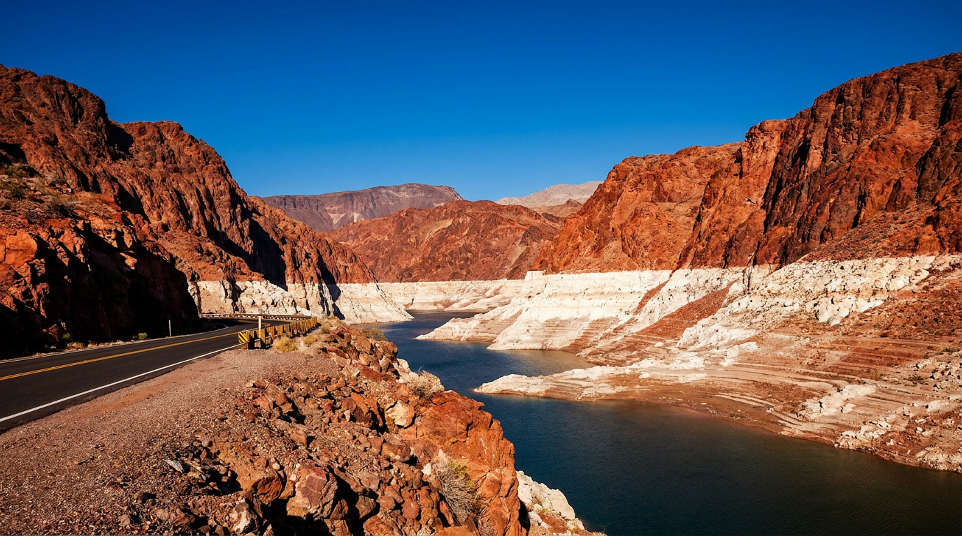
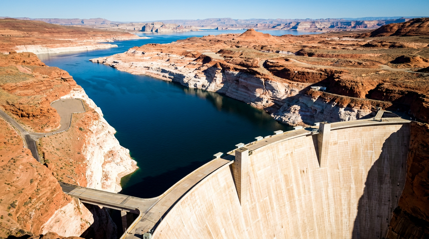
The deficit has been masked by draining the system's massive savings accounts: Lake Mead and Lake Powell. But those reservoirs are now approaching catastrophic lows. Lake Powell recently hit 3,527 feet above sea level—more than 170 feet below capacity and dangerously close to the 3,490-foot minimum power pool required to generate electricity at Glen Canyon Dam.[4][7]
If water levels fall below 3,370 feet at Powell, or 895 feet at Mead, the reservoirs hit dead pool. At that point, water can no longer flow downstream through the dams, effectively cutting off the primary water supply for millions of Americans and halting hydropower production entirely.[7]

The invisible casualty of this deficit is groundwater. As surface water dwindles, agricultural and municipal users have turned to pumping aquifers. Satellite observations reveal that the Colorado River Basin lost 27.8 million acre-feet of groundwater between 2002 and 2024—enough to cover the entire state of Pennsylvania in a foot of water.[3]
As surface water dwindles, agricultural and municipal users have turned to pumping aquifers.
Faced with this reality, the Bureau of Reclamation initiated an Environmental Impact Statement process to establish post-2026 guidelines. They asked the states to submit a consensus plan. Instead, the states fractured into two hostile camps, submitting competing proposals that highlight a deep regional divide.[4][8]
The Lower Basin states—Arizona, California, and Nevada—proposed a framework where water cuts are dictated by total system storage. Under their plan, if the combined reservoirs drop below certain thresholds, cuts would be shared across the entire basin, forcing the Upper Basin to share the pain of a shrinking river.[8]
The Upper Basin states—Colorado, New Mexico, Utah, and Wyoming—vehemently rejected this approach. They argue that because they rely on natural snowpack and streamflow rather than massive reservoirs, their users already take de facto cuts during dry years.[1][8]
The Upper Basin's proposal insists that the Lower Basin, which relies on the steady release of stored water from Lake Mead, must bear the brunt of future curtailments to fix the structural deficit they created. The impasse has led to threats of litigation that could tie up water management in the courts for years.[8]

Frustrated by the deadlock, the federal government has signaled it may intervene. The Bureau of Reclamation has the authority to act as water master for the Lower Basin and could unilaterally impose cuts if the states fail to reach an agreement.[2][8]
The math driving the federal threat is indisputable. Negotiators have repeatedly warned that the basin is overspending a bank account that is almost empty, noting that legal theories cannot conjure water that no longer exists.[7]
Meanwhile, a critical constituency has demanded a seat at the table. The 30 federally recognized Tribes in the basin hold quantified rights to approximately 3.2 million acre-feet of water—up to 26 percent of the river's average supply.[5]
Historically excluded from the 1922 Compact and subsequent negotiations, a coalition of 20 Tribes submitted a joint letter to the Bureau of Reclamation, insisting that any post-2026 framework must protect their senior water rights and include them as primary decision-makers.[5]

Environmental organizations have also entered the fray, submitting a Cooperative Conservation Alternative. They argue that the post-2026 guidelines must prioritize the ecological health of the river, rather than simply managing the decline of a plumbing system for human consumption.[6]
The evidence is unequivocal: the Colorado River can no longer support the demands placed upon it. As the 2026 deadline approaches, the basin faces a choice between managed, equitable reductions or a chaotic, federally imposed rationing system triggered by ecological collapse.[6]
How we got here
1922
The Colorado River Compact is signed, dividing the river between the Upper and Lower Basins based on an assumed annual flow of 16.4 million acre-feet.
2000
A persistent, climate-driven 'megadrought' begins in the American West, significantly reducing the river's annual flow.
2007
The Bureau of Reclamation implements Interim Guidelines to manage shortages and coordinate operations between Lake Powell and Lake Mead.
2019
Basin states sign the Drought Contingency Plan, agreeing to voluntary water reductions to prevent reservoirs from reaching critically low levels.
Feb 2023
Lake Powell hits its all-time lowest elevation of 3,522 feet, dangerously close to losing hydroelectric power generation.
Mar 2024
The Upper and Lower Basin states fail to reach a consensus for post-2026 operations, submitting competing proposals to the federal government.
Dec 31, 2026
The current management guidelines expire, requiring a new framework to be in place.
Viewpoints in depth
Lower Basin States
Argue that water cuts should be shared across the entire basin based on total system storage.
Arizona, California, and Nevada contend that a shrinking river is a basin-wide problem requiring a basin-wide solution. Their post-2026 proposal suggests that when combined reservoir storage drops below certain thresholds, curtailments should be distributed among all users. They emphasize that they have already made significant voluntary cuts to keep Lake Mead afloat and argue it is mathematically impossible to stabilize the system if the Upper Basin refuses to share the burden of climate-driven shortages.
Upper Basin States
Argue that the Lower Basin must bear the brunt of cuts to fix their structural overuse.
Colorado, New Mexico, Utah, and Wyoming maintain that their water users already suffer 'de facto' cuts every year because they rely on natural snowpack and streamflow, which fluctuate wildly. They argue that the Lower Basin has artificially insulated itself from drought by draining Lake Mead and Lake Powell. The Upper Basin's proposal insists that future cuts must target the Lower Basin's structural deficit, warning that forcing Upper Basin users to compensate for Lower Basin overuse violates the foundational Law of the River.
Basin Tribes
Demand direct representation and the protection of their senior, quantified water rights.
The 30 federally recognized Tribes in the Colorado River Basin hold rights to roughly a quarter of the river's average historical flow. Excluded from the original 1922 Compact, Tribal nations are demanding that the post-2026 guidelines formally integrate them into the governance structure. They argue that any new framework must allow them to fully exercise their senior rights—many of which remain undeveloped due to lack of infrastructure—and compensate them fairly if they choose to lease their water to stabilize the system.
Federal Regulators
Prioritize preventing the catastrophic failure of the reservoir and hydroelectric systems.
The Bureau of Reclamation and the Department of the Interior are focused on the physical limits of the infrastructure. Their primary mandate is to prevent Lake Powell and Lake Mead from reaching 'dead pool,' which would halt both water deliveries and hydroelectric power generation for millions. Federal officials have repeatedly warned that if the states cannot reach a consensus agreement that mathematically balances supply and demand, the federal government will exercise its authority to unilaterally impose cuts.
What we don't know
- Whether the Upper and Lower Basin states can bridge their divide before the federal government imposes a unilateral solution.
- How potential lawsuits from states or agricultural districts might delay the implementation of the post-2026 guidelines.
- The exact mechanism by which Basin Tribes will be compensated if they lease their senior water rights to stabilize the system.
Key terms
- Acre-foot
- The volume of water needed to cover one acre of land to a depth of one foot, roughly 326,000 gallons, or enough to supply two to three U.S. households for a year.
- Structural Deficit
- The ongoing imbalance in the Colorado River system where the legally allocated water rights and annual consumptive use consistently exceed the actual amount of water flowing into the river.
- Law of the River
- The complex collection of compacts, federal laws, court decisions, and regulatory guidelines that govern the allocation and management of the Colorado River.
- Bureau of Reclamation
- The federal agency within the Department of the Interior responsible for managing water infrastructure, including dams and reservoirs, across the American West.
- Minimum Power Pool
- The lowest water elevation at which a dam's turbines can safely operate to generate hydroelectric power.
Frequently asked
When do the current Colorado River rules expire?
The 2007 Interim Guidelines and the 2019 Drought Contingency Plans both expire on December 31, 2026.
What is 'dead pool'?
Dead pool occurs when a reservoir's water level drops so low that water can no longer flow downstream through the dam's outlets, cutting off water supply and halting hydroelectric power generation.
How much water is missing from the river?
The river was originally allocated based on an assumed flow of 16.4 million acre-feet per year, but the actual average flow since 2000 has been only 12.4 million acre-feet, creating a massive structural deficit.
Who uses the most water from the Colorado River?
Agriculture is the largest consumer, accounting for approximately 80% of the river's consumptive use, irrigating around 5.5 million acres of farmland across the basin.
Sources
Source coverage
8 outlets
4 viewpoints surfaced


[1]The New York TimesBasin States
Tensions Are Rising Between States That Rely on the Colorado River
Read on The New York Times →[2]Congressional Research ServiceFederal Regulators
Management of the Colorado River: Water Allocations, Drought, and the Federal Role
Read on Congressional Research Service →[3]NASA Earth ObservatoryScientific & Conservation Voices
Colorado River Basin Groundwater Loss
Read on NASA Earth Observatory →[4]U.S. Bureau of ReclamationFederal Regulators
Post-2026 Colorado River Reservoir Operations
Read on U.S. Bureau of Reclamation →[5]Native American Rights FundBasin Tribes
Tribal interests in the future of the Colorado River
Read on Native American Rights Fund →[6]Factlen Editorial TeamScientific & Conservation Voices
Synthesis by Factlen editorial team
Read on Factlen Editorial Team →[7]Sierra ClubScientific & Conservation Voices
Can the Colorado River Survive 2026?
Read on Sierra Club →[8]Pacific InstituteBasin States
Colorado River Deadlines & Incentives
Read on Pacific Institute →


Every angle. Every day.
Get science stories with full source coverage and perspective breakdowns delivered to your inbox.