How North America is building the world's largest wildlife corridors
A multi-million dollar infrastructure push is reconnecting fragmented habitats across the US and Canada, shrinking isolation gaps for vulnerable species and drastically reducing deadly vehicle collisions.
By Factlen Editorial Team
- Conservation Biologists
- Focuses on preserving genetic diversity, reconnecting fragmented habitats, and ensuring climate resilience.
- Indigenous Nations & Co-Managers
- Focuses on traditional stewardship, co-management of ancestral lands, and the expansion of IPCAs.
- Transportation & Safety Officials
- Focuses on reducing wildlife-vehicle collisions, infrastructure economics, and improving public safety.
What's not represented
- · Commercial trucking industry
- · Private land developers
Why this matters
Habitat fragmentation is a leading driver of biodiversity loss and causes billions of dollars in deadly vehicle collisions annually. This massive infrastructure shift proves that economic development and ecological restoration can successfully coexist.
Key points
- North America is undergoing a massive infrastructure push to reconnect fragmented wildlife habitats.
- The US Bipartisan Infrastructure Law provided $350 million for wildlife crossings, with demand outstripping supply by 500%.
- Wildlife crossings pay for themselves over time by drastically reducing costly vehicle collisions.
- The Yellowstone to Yukon initiative has successfully shrunk grizzly bear isolation gaps from 150 miles to just 45 miles.
- Indigenous-led conservation areas (IPCAs) are securing tens of thousands of square kilometers of critical habitat.
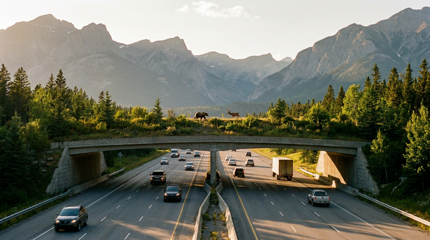
Across North America, more than four million miles of paved roads and highways slice through dense forests, arid deserts, and rugged mountain ranges. For decades, this sprawling, car-centric infrastructure has acted as an invisible cage, trapping wildlife in shrinking islands of habitat and turning routine seasonal migrations into deadly gauntlets. Animals attempting to cross busy interstates face overwhelming odds, leading to catastrophic population declines for vulnerable species and dangerous conditions for human drivers. But a quiet, multi-billion-dollar revolution is currently reshaping the continent's map. Driven by a rare alignment of federal funding, Indigenous leadership, and ecological science, North America is currently undertaking the largest habitat reconnection effort in modern history, fundamentally altering how civil engineering interacts with the natural world.[1]
Rather than simply walling off isolated national parks and hoping for the best, governments, Indigenous nations, and conservationists have shifted their entire philosophy toward "ecological connectivity"—the active process of stitching the North American landscape back together. By building dedicated wildlife crossing infrastructure and establishing vast, co-managed conservation corridors, they are engineering safe passage for everything from migrating pronghorn to apex predators. This approach recognizes that nature is not static; animals must move to find food, secure mates, and adapt to shifting climate zones. When habitats are fragmented by human development, isolated populations suffer from genetic bottlenecks and localized extinctions. The new paradigm treats the landscape as a continuous, living network where human infrastructure must accommodate, rather than block, the ancient rhythms of wildlife movement.[1]
The momentum behind this continental shift has reached unprecedented levels throughout 2025 and 2026, catalyzed by massive injections of public capital. In the United States, the Bipartisan Infrastructure Law established a first-of-its-kind $350 million Wildlife Crossings Pilot Program, specifically earmarked to help states and tribes build dedicated overpasses and underpasses. The initiative proved so overwhelmingly popular that demand from local governments outstripped available funds by a staggering factor of five during the initial grant cycles. In late 2024 and early 2025, the Federal Highway Administration disbursed $125 million to 16 different projects, funding everything from statewide collision hotspot studies to the construction of massive, vegetated land bridges over multi-lane interstates.[2][3]

The broad appeal of these structures easily bridges the usual partisan divides because the underlying economics are completely undeniable. Nationwide, wildlife-vehicle collisions cost billions of dollars annually in property damage, medical bills, and emergency response, while resulting in hundreds of human fatalities. Transportation officials and highway engineers have realized that building vegetated overpasses and guided underpasses is significantly cheaper in the long run than doing nothing. Instead of viewing these projects as environmental charity, state departments of transportation now treat them as highly effective, fiscally responsible safety interventions that protect human lives just as much as they protect local ecosystems.[2][6]
The financial math plays out clearly on the ground in places where the infrastructure has already been tested. In Wyoming, the state built a series of specialized overpasses and underpasses at Trappers Point to protect a historic pronghorn migration route that intersected with a dangerous stretch of U.S. Highway 191. The ambitious project cost $12 million to complete, but state engineers estimate the structures will entirely pay for themselves in just 17 years. By drastically reducing the rate of vehicular damage and the need for highway patrol responses, the crossings provide a continuous return on investment while ensuring the survival of a migration corridor that has been used by pronghorn for thousands of years.[3]
This localized infrastructure is feeding into massive, continent-spanning visions, most notably the Yellowstone to Yukon (Y2Y) Conservation Initiative. Stretching 2,100 miles from the high plains of Wyoming all the way to the Arctic Circle, the Y2Y corridor is widely considered one of the most ambitious large-landscape conservation projects on Earth. Since its inception in 1993, the initiative has worked with hundreds of partners to ensure that the Rocky Mountain ecosystem remains a continuous, unbroken chain of wilderness. Rather than relying on a single government mandate, the Y2Y project weaves together national parks, private land easements, and targeted highway crossings to create a contiguous wildway.[4]
This localized infrastructure is feeding into massive, continent-spanning visions, most notably the Yellowstone to Yukon (Y2Y) Conservation Initiative.
The tangible results of the Y2Y effort are becoming highly visible across the western half of the continent. According to recent impact reports, 204 purpose-built wildlife crossing structures now bridge busy roads across the Yellowstone to Yukon region, with dozens more currently in the planning and construction phases. This physical infrastructure, combined with the conservation of 45,000 hectares of private land in critical bottleneck areas like British Columbia's Elk Valley, is actively repairing the genetic flow of vulnerable species. By securing these vital pinch points, conservationists are ensuring that wide-ranging mammals have the space they need to thrive in a rapidly changing environment.[4]
For apex predators like grizzly bears, the progress is measurable in miles and represents a massive victory for genetic diversity. In 1993, grizzly populations in the lower 48 states were isolated by gaps of up to 150 miles, leaving them trapped in fragmented pockets, highly vulnerable to inbreeding, and at severe risk of localized extinction. Today, thanks to restored corridors and the strategic placement of highway crossings, that isolation gap has shrunk to just 45 miles. This incredible reduction allows previously disparate bear populations to finally reconnect, share genetic material, and establish a much more resilient presence across the Northern Rockies.[4]

Crucially, this modern era of ecological connectivity is being heavily driven by Indigenous leadership and traditional stewardship. In Canada, Indigenous Protected and Conserved Areas (IPCAs) have become the primary engine for meeting international biodiversity targets. These are formal, nation-to-nation agreements where Indigenous governments co-manage vast tracts of land with federal or provincial authorities. Unlike traditional colonial conservation models—which historically evicted native peoples to create pristine, untouched parks—IPCAs recognize that human beings have actively managed and sustained these ecosystems for millennia, and that traditional knowledge is essential to maintaining the health of the landscape.[5]
In the Northwest Territories alone, Indigenous nations have established three massive IPCAs since 2018, protecting over 50,000 square kilometers—an area roughly the size of Costa Rica. Projects like Thaidene Nëné, led by the Łutsël K'e Dene First Nation, ensure that traditional stewardship practices maintain the health of vital caribou herds, salmon runs, and boreal forests. Similarly, the Dehcho First Nations passed a Dene law to protect 14,249 square kilometers of forest, creating the Edéhzhíe protected area. These massive, contiguous blocks of protected land serve as the foundational anchors for North America's broader wildlife corridor network.[5]

Similar Indigenous-led connectivity efforts are rapidly accelerating in the United States, fueled by the new influx of federal infrastructure grants. The Confederated Salish and Kootenai Tribes recently secured $8.6 million to construct wildlife overpasses across U.S. Highway 93 in Montana's Ninepipe National Wildlife Management Area. These structures are specifically designed to reduce grizzly bear collisions and link vital wetland habitats. By directing federal resources directly to tribal governments, the crossing program is not only improving ecological outcomes but also addressing long-standing issues of rural equity and infrastructure underinvestment in tribal communities.[3]
Further south, the Santa Ana Pueblo in New Mexico is utilizing federal funds to track mountain lion and elk movements across tens of thousands of acres of high desert. By deploying GPS collars and mapping exactly where animals attempt to cross the landscape and the Rio Grande corridor, tribal wildlife managers are gathering critical data. This precise tracking allows them to pinpoint the exact locations where future culverts and bridges will be most effective. One tracked mountain lion even traveled more than 550 miles from the Pueblo to Mesa Verde National Park, perfectly illustrating the vast distances these animals require to survive.[6]
The sheer scale of this continental rewiring was recently captured in the 2025 update to the North American Protected Areas map, published by the Commission for Environmental Cooperation. The comprehensive data reveals a shifting landscape where strict nature reserves are increasingly linked by "other effective area-based conservation measures" (OECMs). These OECMs include working lands, private ranches, and managed forests that prioritize biodiversity alongside sustainable human use. The map visually confirms that the continent is slowly transitioning from a patchwork of isolated green islands into a cohesive, interconnected web of life.[7]

As the initial $350 million federal pilot program approaches its final funding rounds in late 2025, a broad and unusual coalition of transportation departments, conservationists, and tribal leaders is actively lobbying Congress to make the funding permanent. With public polling showing 86 percent of Americans support dedicating resources to reduce wildlife-vehicle collisions, the movement has achieved rare bipartisan consensus. For the first time in a century of aggressive highway building, North America is redesigning its infrastructure not just to move people and freight, but to ensure the natural world can safely move alongside them.[2]
How we got here
1993
The Yellowstone to Yukon (Y2Y) Conservation Initiative is founded to connect 2,100 miles of habitat.
2012
Wyoming completes the $12 million Trappers Point crossing project to protect migrating pronghorn.
2018
Indigenous nations in Canada begin establishing massive IPCAs, protecting tens of thousands of square kilometers.
2021
The US passes the Bipartisan Infrastructure Law, creating the $350 million Wildlife Crossings Pilot Program.
2025
The final rounds of the initial federal pilot program are disbursed, with demand outstripping supply by 500%.
Viewpoints in depth
Conservation Biologists
Focuses on preserving genetic diversity and ensuring climate resilience.
Biologists argue that isolated parks are essentially "extinction islands." They point to the shrinking isolation gaps among grizzly bears as proof that corridors work, allowing species to migrate northward as global temperatures rise and ensuring the genetic mixing that prevents localized population collapse.
Indigenous Nations
Focuses on traditional stewardship and the co-management of ancestral lands.
For Indigenous leaders, connectivity is not just about animal biology, but about cultural survival and sovereignty. IPCAs represent a shift away from colonial conservation models—which historically evicted native peoples to create parks—toward a model where traditional knowledge and active human stewardship sustain the land.
Transportation Officials
Focuses on the economics of infrastructure and improving public highway safety.
Highway engineers and state departments of transportation view wildlife crossings primarily as a highly effective safety intervention. With wildlife collisions costing billions in property damage and medical bills, they argue that vegetated overpasses are not environmental charity, but rather fiscally responsible infrastructure upgrades that pay for themselves.
What we don't know
- Whether the US Congress will make the Wildlife Crossings Pilot Program permanent after the initial funding runs out.
- How rapidly shifting climate zones might force animals to abandon currently protected corridors in favor of new, unprotected routes.
Key terms
- Wildlife Crossing Infrastructure (WCI)
- Purpose-built overpasses, underpasses, and culverts designed to allow animals to safely navigate across human-made barriers like highways.
- Ecological Connectivity
- The unimpeded movement of species and the flow of natural processes that sustain life on Earth, often disrupted by human development.
- Indigenous Protected and Conserved Area (IPCA)
- Lands and waters where Indigenous governments have the primary role in protecting and conserving ecosystems through Indigenous laws and knowledge systems.
- Other Effective Area-Based Conservation Measures (OECMs)
- Geographic sites outside of formal protected areas that are managed in ways that deliver long-term biodiversity conservation.
Frequently asked
Do animals actually know how to use the crossings?
Yes, though it often takes time for local populations to adapt. Fencing is used to guide animals toward the structures, and adults eventually teach their young the safe routes.
How much do these structures cost to build?
Costs vary widely depending on scale. A small culvert for amphibians might cost a few hundred thousand dollars, while a massive, vegetated overpass for large mammals can exceed $10 million.
Why is habitat connectivity so important?
Isolated populations suffer from inbreeding and are more vulnerable to disease or localized extinction. Connectivity allows animals to find food, mates, and migrate as climates change.
Sources
Source coverage
7 outlets
3 viewpoints surfaced


[1]Factlen Editorial TeamTransportation & Safety Officials
Synthesis by Factlen editorial team
Read on Factlen Editorial Team →[2]Wildlands NetworkTransportation & Safety Officials
A New Program With New Solutions: Wildlife Crossings Pilot Program
Read on Wildlands Network →[3]The Wildlife SocietyTransportation & Safety Officials
Demand for Wildlife Crossings Program funds outstrips supply
Read on The Wildlife Society →[4]Yellowstone to Yukon Conservation InitiativeConservation Biologists
2025 Impact Report: Reconnecting wild landscapes
Read on Yellowstone to Yukon Conservation Initiative →[5]Indigenous Leadership InitiativeIndigenous Nations & Co-Managers
Indigenous Protected and Conserved Areas: Progress on the Ground
Read on Indigenous Leadership Initiative →[6]The Associated PressIndigenous Nations & Co-Managers
Tribes, states tap into $350M infrastructure fund for wildlife corridors
Read on The Associated Press →[7]Commission for Environmental CooperationConservation Biologists
Terrestrial Ecosystems: North American Protected Areas, 2025
Read on Commission for Environmental Cooperation →

Every angle. Every day.
Get world stories with full source coverage and perspective breakdowns delivered to your inbox.