The Colorado River Compact Nears Collapse as States Deadlock Over Post-2026 Water Cuts
With current operating guidelines expiring at the end of 2026, the seven basin states have failed to reach a consensus on how to manage a shrinking Colorado River. The federal government is now preparing to impose unilateral cuts to prevent the reservoir system from crashing.
By Factlen Editorial Team
- Lower Basin States
- Advocate for shared basin-wide cuts and rely heavily on reservoir storage.
- Upper Basin States
- Argue they already take natural cuts from low snowpack and resist fixed administrative reductions.
- Federal Regulators
- Prioritize the physical survival of the dam infrastructure over historical state allocations.
- Independent Observers
- Focus on the broader economic, legal, and environmental consequences of the deadlock.
What's not represented
- · Agricultural Industry Representatives
- · Tribal Nation Water Authorities
- · Mexican Government Negotiators
Why this matters
The Colorado River sustains 40 million people, 5.5 million acres of agriculture, and the hydroelectric grids of the American Southwest. If the states cannot agree on how to share a permanently shrinking water supply, the federal government will dictate cuts, triggering Supreme Court litigation that could upend a century of water law and dictate the economic future of the region.
Key points
- The 2007 guidelines governing the Colorado River expire at the end of 2026.
- The river's actual flow averages 12.4 million acre-feet, far below the 16.4 million assumed in 1922.
- Upper and Lower Basin states remain deadlocked over how to distribute mandatory water cuts.
- The Bureau of Reclamation will impose a unilateral plan by October 2026 if states fail to agree.
- Federal intervention is highly likely to trigger Supreme Court litigation between the states.
For nearly a century, the American Southwest has grown under a mathematical illusion. The 1922 Colorado River Compact, the foundational document of Western water law, allocated 15 million acre-feet of water between seven states, assuming the river would always provide at least that much. It does not. Driven by a quarter-century of climate-amplified aridification, the river's actual flow has fundamentally decoupled from the legal framework designed to manage it.[6][7]
The crisis is now colliding with a hard legal deadline. The 2007 Interim Guidelines—the rules that dictate how water is rationed from the nation's two largest reservoirs, Lake Mead and Lake Powell—expire on December 31, 2026. The U.S. Bureau of Reclamation (USBR) has mandated that a new framework must be finalized by October 2026 to ensure uninterrupted operations for the 2027 water year.[2][6]
Despite years of negotiations, the seven basin states remain deadlocked over who will absorb the massive cuts required to stabilize the system. The New York Times reports that tensions are rising rapidly as reservoirs dwindle and litigation looms over access to the remaining water.[1]
The math underlying the deadlock is stark. While the original compact assumed an average annual flow of 16.4 million acre-feet, the actual average from 2000 to 2024 was just 12.4 million acre-feet. Meanwhile, basin-wide consumptive use sits at approximately 13.3 million acre-feet. This structural deficit means the basin is consuming roughly a million acre-feet more than nature provides every year, draining the savings accounts of Mead and Powell.[6][7]

The negotiations have fractured along a geographic fault line: the Upper Basin (Colorado, New Mexico, Utah, Wyoming) versus the Lower Basin (Arizona, California, Nevada). The Upper Basin argues that its water users rely directly on seasonal snowpack and therefore take "de facto" cuts every time nature fails to deliver. They contend that the Lower Basin, which relies on the massive storage of Lake Mead, has historically been shielded from these natural fluctuations and must now bear the brunt of the mandated reductions.[4]
The Lower Basin vehemently rejects this framing. Arizona's chief water negotiator has publicly stated that an equitable agreement requires all states to share in the shortages, criticizing the Upper Basin's refusal to accept specific delivery cutbacks during severe droughts. The Lower Basin states have offered to reduce their own allocations by up to 1.25 million acre-feet annually, but only if the burden is distributed basin-wide.[5]
In May 2026, the Lower Basin proposed a two-year bridge plan (2026–2028) to buy time for a long-term solution. The proposal included core reductions and a commitment to conserve an additional 700,000 acre-feet, contingent on federal cost-share funding. The Upper Basin rejected the bridge plan, arguing that reopening negotiations every two years is unworkable, and instead called for a neutral mediator to break the stalemate.[4][7]
In May 2026, the Lower Basin proposed a two-year bridge plan (2026–2028) to buy time for a long-term solution.
With the states unable to reach a consensus, the Bureau of Reclamation is preparing to act unilaterally. In January 2026, the USBR released a Draft Environmental Impact Statement outlining five potential alternatives for post-2026 operations. The alternatives range from "Basic Coordination" under existing law to "Maximum Operational Flexibility," which would give the federal government broad authority to slash deliveries to keep the reservoir system functioning.[2][6]
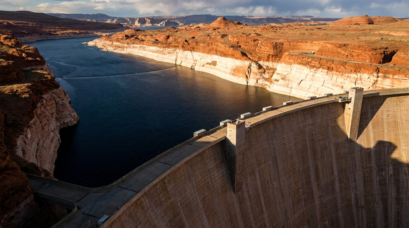
The federal government's primary mandate is protecting the physical infrastructure of the dams, not preserving state water allocations. If Lake Powell drops below 3,490 feet in elevation—the minimum power pool—Glen Canyon Dam will no longer be able to generate hydroelectric power for millions of customers across the West. Forecasts for 2026 show Lake Powell receiving only 13% of its normal spring runoff, a record low that pushes the reservoir dangerously close to this threshold.[4][6]

The prospect of federal intervention has triggered a legal arms race. At a June 2026 Senate Energy and Natural Resources Committee hearing, the hostility was on full display. Senator Mike Lee of Utah threatened to withhold federal funding from any Lower Basin state that sues over the river's management. In response, Lower Basin water agencies, including the Metropolitan Water District of Southern California and the state of Arizona, have begun amassing multi-million-dollar legal war chests.[3]
If the Bureau of Reclamation imposes a unilateral plan, it is almost certain to trigger lawsuits that would send the 1922 Compact directly to the U.S. Supreme Court. Nevada's lead negotiator, John Entsminger, warned that marching into the Supreme Court would be an "abdication of our responsibilities," effectively taking the steering wheel away from the states and handing the economic future of the West to federal judges.[4]
The consequences of these cuts will fundamentally reshape the Western economy. Approximately 80% of the Colorado River's water is used for agriculture, supporting a $5 billion year-round farming industry in places like California's Imperial Valley and Arizona's Yuma County. Any permanent reduction in water deliveries will inevitably require the widespread fallowing of productive farmland, threatening domestic winter vegetable supplies.[1][7]

Complicating the negotiations is the historically marginalized role of the basin's 30 federally recognized Native American tribes. The tribes collectively hold rights to roughly 25% of the river's flow, but many lack the physical infrastructure to divert and use their allocations. Tribal leaders are demanding that the post-2026 guidelines finally integrate their sovereign water rights into the basin's operational framework, rather than treating them as an afterthought.[7]
Ultimately, the Colorado River crisis is no longer a story about a temporary drought. Climate scientists and hydrologists emphasize that the basin is undergoing permanent aridification. Warmer temperatures are increasing evaporation rates and causing snowpack to sublimate directly into the atmosphere before it can reach the river. The 15 million acre-feet promised in 1922 will never return.[4][7]
The Bureau of Reclamation has stated it will issue a Record of Decision by October 1, 2026. The next few months will determine whether the seven states can voluntarily dismantle the mathematical illusion they have lived under for a century, or whether the federal government will be forced to break the compact to save the river.[2][7]
How we got here
1922
The Colorado River Compact divides the river's water, assuming an annual flow of 16.4 million acre-feet.
2007
The Bureau of Reclamation establishes Interim Guidelines to manage shortages as a prolonged drought begins.
Jan 2026
The Bureau of Reclamation releases a Draft Environmental Impact Statement with five alternatives for post-2026 operations.
Feb 2026
The seven basin states miss a federal deadline to submit a consensus plan for future water management.
May 2026
The Lower Basin proposes a two-year bridge plan with 1.25 million acre-feet in cuts; the Upper Basin rejects it.
Oct 2026
The deadline for the Bureau of Reclamation to issue a final Record of Decision for post-2026 operations.
Viewpoints in depth
Lower Basin States
Arizona, California, and Nevada argue that cuts must be shared across the entire basin.
The Lower Basin states rely heavily on the massive storage capacities of Lake Mead to manage their water supplies. They argue that the 1922 Compact requires all seven states to share the burden of a shrinking river. While they have offered to take significant voluntary cuts—up to 1.25 million acre-feet annually—they refuse to do so unless the Upper Basin also commits to specific, measurable delivery reductions during periods of severe drought. They view the Upper Basin's refusal to accept fixed cuts as an existential threat to their municipal and agricultural economies.
Upper Basin States
Colorado, New Mexico, Utah, and Wyoming argue they already absorb the natural impacts of the drought.
The Upper Basin states do not have a massive reservoir like Lake Mead sitting above them to buffer against dry years; they rely directly on seasonal snowpack. When it doesn't snow, their farmers and cities simply do not get water. Because they already take these 'de facto' natural cuts, they argue it is fundamentally unfair to demand they take additional, fixed administrative cuts. They contend that the Lower Basin has historically overused its allocations by relying on reservoir storage and must now bear the brunt of the mandated reductions to balance the system.
Federal Regulators
The Bureau of Reclamation is prioritizing the physical survival of the dam infrastructure.
For the federal government, the primary concern is preventing a catastrophic failure of the reservoir system. If water levels drop below the intake tubes at Glen Canyon Dam or Hoover Dam, water can no longer flow downstream, and hydroelectric generation ceases. The Bureau of Reclamation's proposed alternatives reflect a willingness to aggressively slash water deliveries to all states—regardless of historical legal rights—if it is necessary to keep the physical infrastructure functioning and prevent the reservoirs from reaching 'dead pool.'
What we don't know
- Whether the federal government will choose an alternative that heavily favors one basin over the other.
- How the Supreme Court would rule on the ambiguities of the 1922 Compact if the states sue.
- Exactly how much federal funding will be required to compensate farmers for fallowing their land.
Key terms
- Acre-foot
- The volume of water required to cover one acre of land to a depth of one foot, roughly enough to supply two to three households for a year.
- Structural Deficit
- The ongoing imbalance where the amount of water legally allocated and consumed exceeds the amount of water nature actually provides to the river.
- Minimum Power Pool
- The lowest water elevation at which a reservoir can still push water through a dam's turbines to generate hydroelectricity.
- Dead Pool
- The critical point where water levels fall so low that water can no longer flow downstream through the dam's release valves.
- Aridification
- The long-term, climate-driven transition of a region to a permanently drier state, distinct from a temporary drought.
Frequently asked
Why are the current rules expiring?
The 2007 Interim Guidelines were designed as a temporary measure to manage what was thought to be a short-term drought. They were set to expire in 2026 to force the states to negotiate a long-term solution.
What happens if the states don't agree?
The U.S. Bureau of Reclamation has the authority to impose a federal management plan to protect the dams and reservoirs, which would likely trigger massive lawsuits from the states.
How does this affect regular people?
Severe cuts could lead to mandatory water rationing in major cities like Phoenix and Los Angeles, higher water and electricity prices, and reduced agricultural output, which could raise food prices.
Can desalination or recycling solve this?
While cities are investing heavily in water recycling and exploring desalination, these technologies are expensive and currently cannot produce enough volume to replace the millions of acre-feet missing from the river.
Sources
Source coverage
7 outlets
4 viewpoints surfaced


[1]The New York TimesIndependent Observers
Tensions Are Rising Between States That Rely on the Colorado River
Read on The New York Times →[2]U.S. Bureau of ReclamationFederal Regulators
Post-2026 Operational Guidelines and Strategies for Lake Powell and Lake Mead
Read on U.S. Bureau of Reclamation →[3]Circle of BlueIndependent Observers
Tensions in the Colorado River basin on display during Senate hearing
Read on Circle of Blue →[4]Aspen Public RadioUpper Basin States
Reclamation's plan for post-2026 operating guidelines
Read on Aspen Public Radio →[5]Arizona Department of Water ResourcesLower Basin States
Colorado River negotiations break down just prior to federal deadline
Read on Arizona Department of Water Resources →[6]Congressional Research ServiceFederal Regulators
Management of the Colorado River: Water Allocations, Drought, and the Federal Role
Read on Congressional Research Service →[7]Factlen Editorial TeamIndependent Observers
Synthesis by Factlen editorial team
Read on Factlen Editorial Team →

Every angle. Every day.
Get science stories with full source coverage and perspective breakdowns delivered to your inbox.