Life-Threatening Flash Floods Submerge Central Texas, Stranding Drivers on I-35
A slow-moving storm system dumped up to seven inches of rain across Central Texas overnight, triggering widespread flash flooding and high-water rescues. Interstate 35 in Waco was completely submerged, while emergency declarations and flood watches remain in effect for millions of residents.
By Factlen Editorial Team
- Emergency Responders
- Focusing on immediate life safety, water rescues, and enforcing road closures.
- Meteorologists
- Tracking the slow-moving storm system and warning of compounding multi-day flood risks.
- Stranded Motorists
- Experiencing the terrifyingly rapid rise of floodwaters on major commuting routes.
What's not represented
- · Local business owners facing property damage and lost revenue due to the sudden flooding.
- · Uninsured homeowners navigating the immediate aftermath of water entering their residences.
Why this matters
The sudden inundation of major transportation arteries like Interstate 35 highlights the extreme vulnerability of Central Texas infrastructure to rapid rainfall. For millions of residents from Waco to San Antonio, the ongoing multi-day flood threat requires immediate changes to commuting plans and heightened vigilance against deceptively deep waters.
Key points
- A slow-moving storm system dumped up to seven inches of rain across the Texas Hill Country overnight.
- Interstate 35 in Waco was completely submerged, requiring state troopers to rescue stranded drivers.
- Governor Greg Abbott activated state emergency resources, including swiftwater rescue boat squads.
- San Antonio International Airport broke a daily rainfall record that had stood since 1894.
- A Flood Watch remains in effect for all of South-Central Texas through Tuesday evening.
A relentless, slow-moving storm system unleashed life-threatening flash floods across Central Texas early Monday morning, submerging major highways and prompting a massive, multi-county emergency response. The severe weather setup, driven by a collision between deep tropical moisture and a stalled cold front, dumped staggering amounts of rain over a highly concentrated area in a matter of hours. As the sun rose, millions of residents from Waco down to San Antonio awoke to flooded neighborhoods, impassable commuting routes, and urgent warnings from local authorities to shelter in place. The sheer volume of water quickly overwhelmed municipal drainage systems, transforming routine morning drives into dangerous survival situations.[1][7]
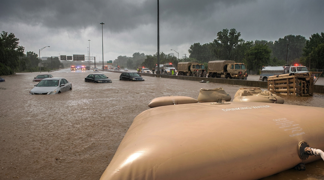
The most dramatic and terrifying scenes unfolded in Waco, where torrential downpours completely inundated all lanes of Interstate 35, one of the state's most vital transportation arteries. Multiple drivers found themselves suddenly trapped in rapidly rising, waist-high water as the massive highway transformed into a rushing river. The situation escalated so quickly that motorists were forced to abandon their vehicles or wait on the roofs of their cars for rescue. State troopers and local emergency crews had to hastily open adjacent access roads and deploy specialized equipment to reach the stranded commuters before the floodwaters could sweep them away.[3][7]
Further south, the San Antonio and Austin metropolitan areas were hammered by relentless rainfall rates of one to three inches per hour, creating a highly volatile environment for morning commuters. In Austin, a city notoriously prone to flash flooding due to its unique topography, nearly two dozen low-water crossings were shuttered by the city's early warning system before dawn. Meanwhile, San Antonio emergency crews were forced to execute multiple high-water rescues, pulling desperate motorists from submerged vehicles that had driven into deceptively deep waters at flooded intersections.[1][5]

The sheer volume of water delivered by the stationary thunderstorms overwhelmed local infrastructure almost instantly, breaking historical records in the process. Isolated pockets of the Texas Hill Country recorded more than seven inches of rain overnight, instantly turning dry creek beds into raging torrents. At San Antonio International Airport, the overnight deluge shattered a daily rainfall record that had stood untouched since 1894, underscoring the historic nature of the storm. The rapid accumulation left municipal water management systems entirely incapable of keeping pace with the runoff.[1][5]
The sheer volume of water delivered by the stationary thunderstorms overwhelmed local infrastructure almost instantly, breaking historical records in the process.
In response to the escalating crisis and the rising number of stranded residents, Governor Greg Abbott directed the Texas Division of Emergency Management to activate state resources, deploying swiftwater rescue boat squads and hoist-capable helicopters to the hardest-hit zones. Texas Game Wardens reported conducting numerous high-stakes rescues across Bell, Falls, McLennan, and Milam counties as conditions rapidly deteriorated throughout the morning. These specialized teams are operating at maximum capacity, navigating treacherous currents to reach individuals trapped in vehicles and low-lying homes.[4][8]
Local officials across the region are pleading with residents to stay off the roads entirely, emphasizing that the danger is far from over. The City of Waco issued urgent alerts warning that major thoroughfares, including Waco Drive and Valley Mills Drive, were experiencing severe washouts that compromised the structural integrity of the pavement. In San Antonio, a complex high-water rescue forced the complete closure of all westbound lanes on Loop 410 at Jackson Keller Road, effectively paralyzing the morning commute and leaving thousands of drivers gridlocked in hazardous conditions.[2][4]

The meteorological setup driving the disaster shows little sign of abating, leaving forecasters deeply concerned about the days ahead. Because a stationary frontal boundary has locked the storm cells in place, the region is being subjected to a continuous firehose of tropical moisture funneling in from the Gulf of Mexico. In response to the persistent threat, the National Weather Service has issued a comprehensive Flood Watch for all of South-Central Texas that remains in effect through Tuesday evening, warning that the worst may not be over.[1][7]
Forecasters warn that the region faces a compounding, multi-day threat that will only grow more dangerous as the week progresses. With the ground already heavily saturated from previous spring storms, the soil can absorb virtually no more moisture, meaning even moderate additional rainfall will trigger immediate and catastrophic runoff. As the storm system slowly shifts eastward toward Louisiana and Mississippi, emergency management teams across the Deep South are bracing for a prolonged week of high-stakes rescues, infrastructure strain, and widespread disruption to daily life.[1][6]
How we got here
Sunday Night
A stationary frontal boundary collides with deep tropical moisture, initiating heavy rainfall over the Texas Hill Country.
Early Monday
Rainfall rates of 1 to 3 inches per hour trigger flash flooding, submerging I-35 in Waco and forcing road closures in Austin and San Antonio.
Monday Morning
Governor Abbott activates the Texas Division of Emergency Management to deploy swiftwater rescue teams.
Tuesday Evening
The current Flood Watch for South-Central Texas is scheduled to expire, though the threat may shift eastward.
Viewpoints in depth
Emergency Responders
First responders emphasize the life-or-death stakes of ignoring road closures.
Local police, fire departments, and the Texas Game Wardens are operating at maximum capacity, focusing entirely on life-safety missions and high-water rescues. They express deep frustration with motorists who bypass barricades or attempt to drive through moving water, noting that floodwaters frequently conceal washed-out pavement and hidden debris. Their primary directive to the public is 'Turn Around, Don't Drown,' stressing that the majority of flood-related fatalities occur in vehicles.
Meteorologists
Forecasters warn of a compounding, multi-day threat driven by saturated soils.
The National Weather Service and independent forecasters are sounding the alarm over the specific mechanics of this storm system. Because a stationary frontal boundary has locked the storms in place, the region is being subjected to a 'firehose' of tropical moisture. Meteorologists emphasize that because the ground is already heavily saturated from previous spring storms, it will take significantly less rain than usual to trigger immediate and catastrophic runoff in the coming days.
Stranded Motorists
Drivers caught in the floods describe a terrifyingly rapid escalation of water levels.
Residents and commuters who found themselves trapped on major arteries like Interstate 35 and Loop 410 report that the water rose with shocking speed. Many described driving in heavy but seemingly manageable rain, only to suddenly encounter deep, impassable water that stalled their engines. Survivors have taken to social media to express gratitude for the structural integrity of highway retaining walls and the rapid intervention of state troopers, noting how quickly a routine commute turned into a fight for survival.
What we don't know
- The total number of vehicles damaged or abandoned in the floodwaters across the state.
- The full extent of the structural damage to local roads, bridges, and low-water crossings.
- Exactly how much additional rainfall the stalled frontal boundary will produce before shifting eastward.
Key terms
- Flash Flood
- A rapid flooding of low-lying areas, rivers, and streams, typically caused by intense rainfall over a short period of time.
- Low-Water Crossing
- A road or bridge that is built close to the water level of a stream or river, making it highly susceptible to flooding during heavy rain.
- Stationary Front
- A weather front between two air masses that is barely moving, often resulting in prolonged periods of continuous rain over the same area.
Frequently asked
Which areas are most affected by the flooding?
The heaviest impacts are concentrated along the Interstate 35 corridor, particularly in Waco, Austin, and San Antonio, as well as the surrounding Texas Hill Country.
Is it safe to drive in Central Texas right now?
Emergency officials strongly advise against travel in the affected areas. Dozens of roads and low-water crossings are closed, and drivers are urged to never attempt to cross flooded roadways.
How long will the flood threat last?
A Flood Watch remains in effect for South-Central Texas through Tuesday evening, and forecasters warn that the region faces a multi-day threat as the storm system slowly moves eastward.
Sources
Source coverage
8 outlets
3 viewpoints surfaced


[1]FOX WeatherMeteorologists
Live updates: Life-threatening flash flood threat targets Texas, Louisiana amid tropical trouble
Read on FOX Weather →[2]MySAStranded Motorists
Heavy rain triggers flood warnings across San Antonio
Read on MySA →[3]FOX 4 Dallas-Fort WorthStranded Motorists
Flash flooding strands drivers on I-35 in Waco
Read on FOX 4 Dallas-Fort Worth →[4]KCEN TVEmergency Responders
Active Flooding and Road Closures across Waco, Temple, Killeen and the surrounding area
Read on KCEN TV →[5]Houston ChronicleMeteorologists
Flash flood warning issued for San Antonio Monday: Travel not advised
Read on Houston Chronicle →[6]NewsweekMeteorologists
Texas Map Shows Large Parts of State Under Flood Warnings
Read on Newsweek →[7]ABC NewsStranded Motorists
Dangerous flooding ongoing in Texas, with flash flood risks across the region
Read on ABC News →[8]Office of the Texas GovernorEmergency Responders
State Emergency Response Resources Activated Ahead of Flood Threat
Read on Office of the Texas Governor →


Every angle. Every day.
Get news politics stories with full source coverage and perspective breakdowns delivered to your inbox.