How Robotaxis See the World: The Mechanics of Sensor Fusion
Modern autonomous vehicles rely on a complex 'sensor fusion' of cameras, LiDAR, and radar to navigate safely. By layering these technologies, robotaxis create a superhuman, 3D model of their environment that exceeds human perception.
By Factlen Editorial Team
- Autonomous Vehicle Engineers
- Focus on redundancy and multi-modal sensor fusion to ensure safety.
- AI Safety Researchers
- Focus on edge-case handling and the need for explainable AI in perception systems.
- Hardware Innovators
- Focus on driving down component costs and developing biomimetic sensor technology.
What's not represented
- · City Planners
- · Traditional Automakers
Why this matters
As robotaxis expand into more cities globally, understanding how these vehicles perceive the world demystifies the technology, building the public trust necessary for a safer, fully autonomous transportation future.
Key points
- Autonomous vehicles use 'sensor fusion' to combine data from cameras, LiDAR, and radar.
- Cameras provide color and classification but struggle in poor lighting and heavy rain.
- LiDAR creates a precise 3D map of the environment but can be scattered by precipitation.
- Radar acts as a weatherproof backup, detecting speed and distance regardless of visibility.
- Newer hardware generations are reducing total sensor counts while increasing range and lowering costs.
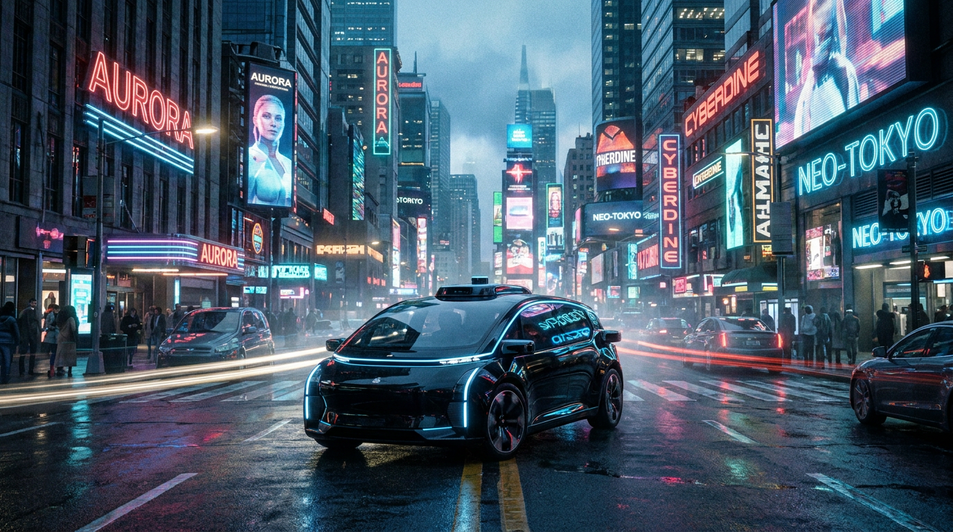
Stepping into a vehicle with no driver for the first time is a surreal experience. The initial apprehension usually fades as the steering wheel turns itself with eerie precision, navigating complex intersections and yielding to pedestrians. But beneath the smooth ride lies a profound engineering question: How does an empty car actually "see" the chaotic, unpredictable urban environment better than a human driver? The answer is a masterclass in modern robotics, relying on an invisible orchestra of data that constantly maps the physical world in real time.
The foundation of this capability is a concept known as "sensor fusion." Unlike human drivers who rely almost entirely on two eyes and a biological brain, Level 4 autonomous vehicles—such as those operated by Waymo, Zoox, and Baidu—use an overlapping array of distinct sensor modalities to build a flawless, 360-degree model of the world. By combining different types of hardware, the vehicle's central computer can perceive its environment with a level of detail and reliability that far exceeds human capability.[2][8]
The core philosophy behind sensor fusion is that no single sensor is perfect. Every technology has a distinct "failure envelope," meaning it has specific environmental conditions where it effectively goes blind. To achieve the rigorous safety thresholds required for unsupervised driving on public roads, engineers must layer different types of sensors. This creates a highly redundant, fail-safe system where the inherent weaknesses of one sensor are seamlessly covered by the strengths of another, ensuring the vehicle never loses its situational awareness.[1]
The first layer of this digital perception system is the camera network. Modern robotaxis are equipped with anywhere from 10 to 30 high-resolution cameras strategically placed around the chassis to provide a continuous, full-color view of the vehicle's surroundings. These cameras act as the vehicle's primary eyes, capturing the visual texture of the world much like a human driver would, but with the added benefit of overlapping fields of view that completely eliminate blind spots, allowing the car to monitor all directions simultaneously.[2]

Cameras excel at complex classification tasks. They are the only sensors in the autonomous suite that can read the text on a detour sign, determine the exact color of a traffic light, or distinguish between a pedestrian waiting to cross and a cardboard cutout on the sidewalk. However, cameras are passive sensors; they rely entirely on ambient light to function. Consequently, their performance drops significantly in heavy rain, dense fog, or when faced with sudden, blinding glare from a setting sun, necessitating backup systems.[2][4]
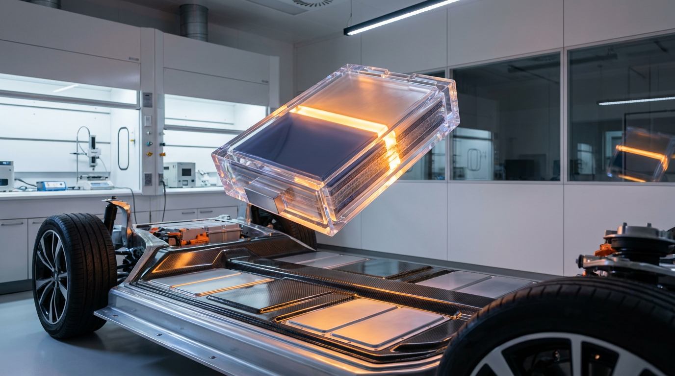
To solve the depth and lighting problem, autonomous vehicles rely heavily on LiDAR, which stands for Light Detection and Ranging. LiDAR units typically sit on the roof and bumpers of the vehicle, rapidly firing millions of invisible laser pulses per second into the surrounding environment. By measuring exactly how long it takes for each laser pulse to bounce back from an object, the sensor can calculate precise distances with millimeter-level accuracy, regardless of whether it is broad daylight or pitch black.[2][3]
This rapid laser firing creates a dense, highly accurate "point cloud"—a real-time 3D topographical map of everything around the car. LiDAR can detect the exact shape of a cyclist, the precise distance to a curb, and the volume of a parked car. While it provides unmatched spatial precision, LiDAR is historically expensive and power-hungry. Furthermore, because it relies on light pulses, its lasers can be scattered by heavy precipitation, reducing its overall effectiveness in the middle of a severe rainstorm or blizzard.[2][3][4]

This rapid laser firing creates a dense, highly accurate "point cloud"—a real-time 3D topographical map of everything around the car.
That is where the third critical modality comes in: Radar. While radar lacks the fine-grained resolution to tell a motorcycle from a small car, its radio waves punch right through rain, snow, fog, and dust. Radar provides a weatherproof baseline for the vehicle, constantly measuring the speed and distance of large moving objects. This ensures that the robotaxi can maintain a safe following distance and will never rear-end the car ahead, even when visibility drops to near zero and optical sensors are compromised.[2][3]
Gathering this immense volume of data is only half the battle; the true magic happens in the vehicle's onboard computer through the process of sensor fusion. The system synchronizes the massive data streams from the cameras, LiDAR, and radar—often updating dozens of times per second—to create a unified, real-time situational awareness model. Advanced machine learning algorithms weigh the inputs from each sensor, constantly cross-referencing the data to confirm the presence, speed, and trajectory of every object in the vehicle's vicinity.[1][3][9]
This redundancy allows the vehicle to handle unpredictable edge cases gracefully. If the cameras are temporarily blinded by the setting sun, the LiDAR and radar seamlessly take over the primary tracking duties without missing a beat. If a GPS signal drops while driving through a long tunnel, the vehicle compares its live LiDAR point cloud against pre-loaded high-definition maps to pinpoint its exact location down to the centimeter, ensuring it stays perfectly centered in its lane until the satellite connection is restored.[2][4]
This perception technology is rapidly maturing, becoming both more capable and more efficient. In early 2026, Waymo began scaling its 6th-generation hardware suite, which dramatically reduced the total number of sensors while actually increasing the vehicle's overall capability. This marks a significant milestone in the evolution of autonomous driving, proving that smarter software, higher-resolution components, and strategic sensor placement can achieve higher safety standards without requiring vehicles to bristle with dozens of redundant, bulky hardware pods on every surface.[5][6]
Waymo's latest system utilizes 13 cameras, four LiDARs, and six radar units—a 42 percent reduction in total sensors compared to the previous generation that operated on their Jaguar fleet. Despite the leaner setup, the new sensor suite allows the vehicle to see up to 500 meters away in all directions, with overlapping fields of view that provide a comprehensive surround-view of the world. The system is also designed with advanced weather resilience, featuring mechanical cleaning systems to keep the sensors clear in snow and rain.[5][6]

This hardware consolidation is driving down costs, a crucial step for the widespread commercial adoption of robotaxis. The 6th-generation sensor suite reportedly costs less than $20,000 per vehicle, a massive drop from the early days of autonomous testing when a single experimental LiDAR unit could cost upwards of $75,000. As these costs continue to fall, fleet operators can scale their services to more cities, transforming autonomous ride-hailing from a niche novelty into a standard, accessible mode of urban public transportation.[5]
Meanwhile, researchers are already working on the next leap in perception hardware to make these systems even more robust. In June 2026, engineers at Penn State University published a breakthrough in the journal Nature Communications, detailing a new sensor component called a "photomemristor." This microscopic device breaks from traditional computer vision approaches by taking direct inspiration from the biological mechanics of the human eye, specifically its innate ability to rapidly adapt to extreme and sudden shifts in environmental lighting without losing visual fidelity.[7]
Roughly the size of a grain of sand, the photomemristor can adjust between bright and dark lighting environments in a matter of seconds. While traditional computer vision systems can be temporarily blinded by a flashing ambulance light or the sudden transition of exiting a dark tunnel into bright sunlight, this biomimetic sensor adapts almost instantly. Incorporating this technology into future autonomous fleets promises to make them significantly more reliable in mixed lighting, eliminating one of the final hurdles in optical perception for self-driving cars.[7]

Ultimately, the goal of sensor fusion is not just to replicate human vision, but to comprehensively exceed it. By combining the nuanced color recognition of cameras, the pinpoint 3D accuracy of LiDAR, and the all-weather reliability of radar, autonomous vehicles are creating an invisible, superhuman safety net on city streets. As this technology continues to evolve and scale, the once-daunting prospect of riding in a driverless car is rapidly becoming one of the safest, most predictable ways to navigate the modern world.[8]
How we got here
2004
Early autonomous vehicle prototypes rely on massive, expensive LiDAR systems during the DARPA Grand Challenge.
August 2024
Waymo unveils its 6th-generation sensor suite, drastically reducing the number of sensors while extending visibility up to 500 meters.
February 2026
Waymo begins operating its 6th-generation hardware without safety drivers on public roads, marking a milestone in cost-effective autonomy.
June 2026
Penn State researchers publish a breakthrough on photomemristors, a microscopic sensor that mimics the human eye to handle sudden lighting changes.
Viewpoints in depth
Autonomous Vehicle Engineers
Focus on redundancy and multi-modal sensor fusion to ensure safety.
Engineers argue that true Level 4 autonomy is impossible without overlapping sensor modalities. They emphasize that cameras, while excellent for classification, are too fragile in adverse weather. By layering LiDAR and radar, they create a fail-safe system where the weaknesses of one sensor are covered by the strengths of another, ensuring the vehicle never loses its situational awareness.
AI Safety Researchers
Focus on edge-case handling and the need for explainable AI in perception systems.
Safety researchers highlight the 'black box' nature of complex sensor fusion algorithms. While the hardware can capture a perfect 3D model of the environment, researchers stress the need for explainable AI (XAI) to understand exactly how the vehicle's computer weighs conflicting data—for example, if the camera sees a green light but the radar detects a vehicle running the intersection.
Hardware Innovators
Focus on driving down component costs and developing biomimetic sensor technology.
Hardware developers believe the key to scaling robotaxis lies in driving down the cost of perception suites while increasing their adaptability. They champion innovations like solid-state LiDAR and Penn State's new 'photomemristor,' arguing that mimicking biological functions—like the human eye's rapid adjustment to light—will eventually make autonomous sensors cheaper and more resilient than current bulky arrays.
What we don't know
- How quickly biomimetic sensors like photomemristors can be manufactured at commercial scale.
- Whether camera-only approaches will eventually catch up to the reliability of multi-modal sensor fusion.
- How autonomous perception systems will handle the most extreme, unprecedented weather events that even human drivers cannot navigate.
Key terms
- Sensor Fusion
- The computational process of combining data from multiple distinct sensors to create a single, highly accurate model of the environment.
- LiDAR
- Light Detection and Ranging; a sensor that fires millions of laser pulses per second to measure distances and create a precise 3D map of its surroundings.
- Point Cloud
- A dense 3D topographical map generated by LiDAR, representing the exact shapes and distances of objects in the environment.
- Level 4 Autonomy
- A classification of self-driving where the vehicle can handle all driving tasks without human intervention within specific geographic areas and conditions.
- Photomemristor
- A microscopic, experimental sensor component designed to mimic the human eye's ability to rapidly adjust to sudden changes in lighting.
- High-Definition (HD) Mapping
- Ultra-precise digital maps that include lane geometry, curb heights, and traffic signal positions, used by autonomous vehicles for exact localization.
Frequently asked
Can robotaxis drive safely in heavy rain or fog?
Yes, though their optical capabilities are reduced. While cameras and LiDAR struggle in heavy precipitation, autonomous vehicles rely on radar, which uses radio waves to reliably detect the speed and distance of objects in all weather conditions.
What happens if a sensor breaks while the car is driving?
Modern robotaxis are built with massive redundancy. If a camera or LiDAR unit fails, the vehicle's computer seamlessly relies on the overlapping fields of view from its dozens of other sensors to safely pull over or complete the trip.
Why are the sensor suites getting smaller?
Advancements in sensor technology and strategic placement have allowed companies like Waymo to reduce their total sensor count by over 40% in their latest generation, lowering costs while actually increasing the vehicle's detection range.
Sources
Source coverage
9 outlets
3 viewpoints surfaced


[1]Sensor Fusion AuthorityAutonomous Vehicle Engineers
Sensor Fusion in Autonomous Vehicles
Read on Sensor Fusion Authority →[2]RoboTaxis AustraliaAutonomous Vehicle Engineers
How RoboTaxis See the World
Read on RoboTaxis Australia →[3]Neural ConceptAI Safety Researchers
Self-driving car machine learning explained
Read on Neural Concept →[4]UDHYAI Safety Researchers
How Self‑Driving Cars See the World
Read on UDHY →[5]ElectrekHardware Innovators
Waymo's 6th-gen sensor suite
Read on Electrek →[6]WaymoAutonomous Vehicle Engineers
Our 6th-generation system
Read on Waymo →[7]Popular ScienceHardware Innovators
A tiny new sensor component could help autonomous vehicles see better
Read on Popular Science →[8]Factlen Editorial TeamHardware Innovators
Synthesis by Factlen editorial team
Read on Factlen Editorial Team →[9]MDPIAI Safety Researchers
Multi-Sensor Fusion in Autonomous Vehicles
Read on MDPI →
Every angle. Every day.
Get automotive stories with full source coverage and perspective breakdowns delivered to your inbox.