How AI and Drones Are Accelerating Global Landmine Clearance
Artificial intelligence and commercial drones are transforming humanitarian demining, increasing survey productivity by 800% and offering a high-tech solution to a century-long crisis.
By Factlen Editorial Team
- Humanitarian Deminers
- Prioritizing the safe and rapid return of contaminated land to civilian use.
- Technology Developers
- Focusing on algorithmic accuracy, sensor fusion, and scaling cloud compute.
- Academic Researchers
- Focusing on empirical validation, thermal detection rates, and pushing the boundaries of machine learning models.
- Independent Analysts
- Evaluating the empirical data and broader societal impact of demining innovations.
What's not represented
- · Local farmers and civilians living in contaminated zones
- · Military engineers deploying the mines
Why this matters
With over 110 million landmines buried globally, traditional clearance methods were projected to take 1,100 years. This technological breakthrough is dramatically accelerating the return of safe, arable land to communities, saving thousands of lives and millions of dollars in the process.
Key points
- Traditional landmine clearance relies on slow, dangerous manual probing, with estimates suggesting it would take 1,100 years to clear the globe.
- Commercial drones equipped with visual, thermal, and magnetic sensors are now being used to map hazardous areas from the air.
- Cloud-based artificial intelligence models can analyze these drone images in fractions of a second, identifying explosives with over 90% accuracy.
- A recent 18-month field study demonstrated that AI-assisted surveys increased demining productivity by 800% while cutting labor costs in half.
- While drones dramatically accelerate the detection phase, the physical excavation of landmines remains a manual and hazardous task.
For decades, the arithmetic of landmine clearance has been a source of despair for humanitarian organizations. A standard anti-personnel mine costs as little as $3 to manufacture and deploy, yet safely locating and removing it costs between $300 and $1,000.[4]
With an estimated 110 million landmines buried across more than 60 countries, the United Nations has starkly projected that at current clearance rates, it would take 1,100 years to rid the world of these hidden threats.[4]
The human toll of this slow progress is devastating. In 2021 alone, explosive remnants of war killed or maimed over 5,500 people globally, the vast majority of whom were civilians and children attempting to farm or play on contaminated land.[4]
But a convergence of commercial drone technology, cloud computing, and computer vision is rapidly rewriting that timeline. Over the past 18 months, artificial intelligence has transitioned from an experimental academic concept to a frontline tool in the world’s most heavily mined regions.[1][6]

The traditional approach to demining is agonizingly slow and inherently perilous. Human technicians must walk suspected hazardous areas in heavy protective gear, sweeping the ground with metal detectors and manually probing the soil inch by inch.[5]
This manual method inevitably churns up false positives—nails, spent bullet casings, and harmless shrapnel—wasting valuable time. Tragically, the United Nations reports that for every 5,000 mines successfully recovered, three clearance workers are injured or killed in the process.[5]
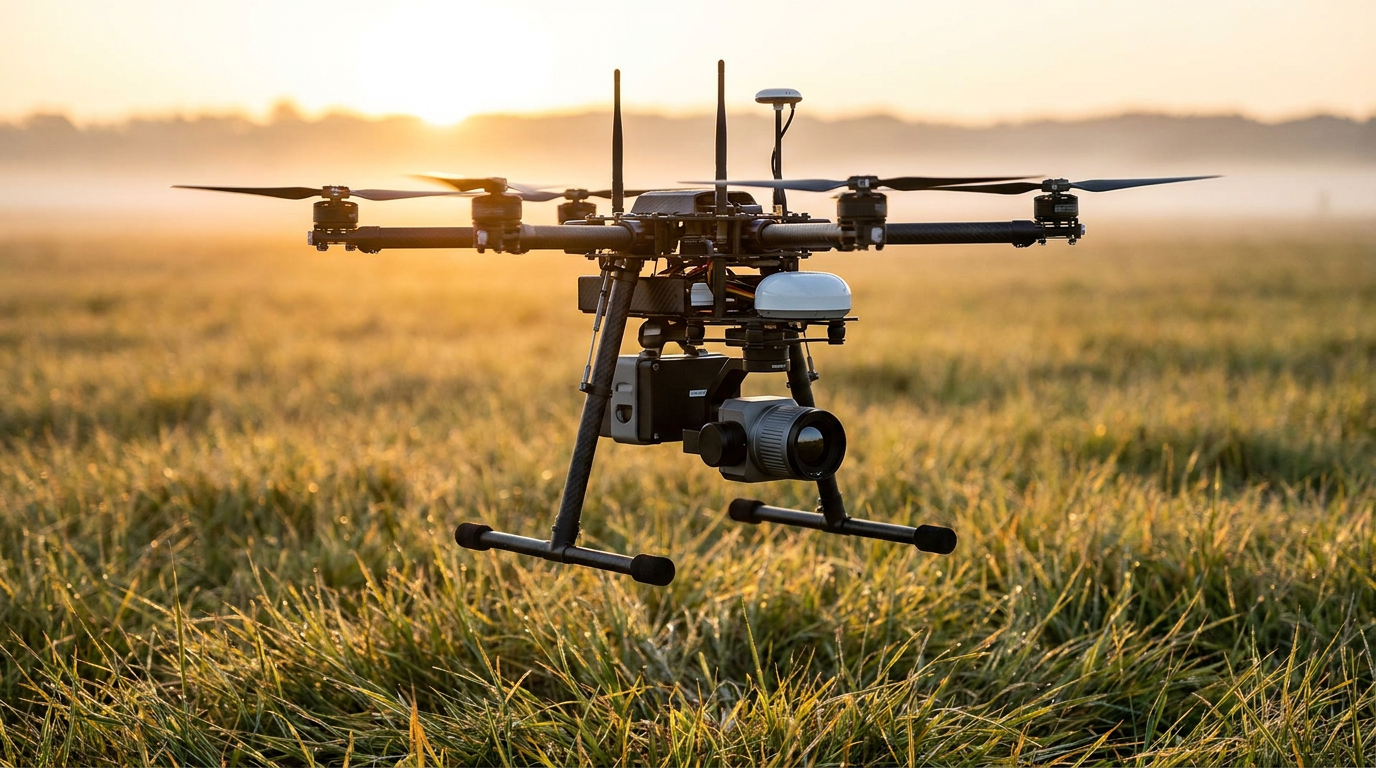
The new paradigm shifts the initial risk from humans to machines. Commercial off-the-shelf drones equipped with high-resolution RGB cameras, thermal imaging, and magnetometers are now deployed to map suspected minefields safely from the air.[4][5]
The true breakthrough lies not in the drones themselves, but in the artificial intelligence analyzing the data they capture. Machine learning models, trained on hundreds of thousands of images of various munitions, can spot visual and thermal anomalies that are entirely invisible to the human eye.[6]
The empirical evidence for this approach is striking. A recent 18-month field study conducted by Norwegian People's Aid evaluated the impact of AI-analyzed drone imagery on "non-technical surveys"—the crucial first step of identifying hazardous zones before physical clearance begins.[1]
The findings, presented at the Geneva International Centre for Humanitarian Demining Innovation Conference, revealed that AI-assisted teams achieved an 800% increase in productivity compared to traditional manual survey methods.[1]

Furthermore, the technology identified 550% more potentially hazardous items per hectare and reduced survey labor costs by approximately 50%. By pinpointing exactly where the threats are, specialized clearance teams can bypass safe zones and focus their efforts exclusively on contaminated land.[1]
Furthermore, the technology identified 550% more potentially hazardous items per hectare and reduced survey labor costs by approximately 50%.
Academic research corroborates these field results. A study published by researchers from Binghamton University and Columbia University demonstrated that a region-based convolutional neural network (R-CNN) could detect the notorious PFM-1 "butterfly" mine with 91.8% accuracy.[3]
The system achieves this high accuracy by sensing minute temperature differences between the explosive device and the surrounding soil and vegetation during specific times of the day, effectively turning the environment's natural thermal dynamics into a detection tool.[5]
The processing speed of these AI models has also crossed a critical threshold. Platforms like Safe Pro Group’s SpotlightAI, utilizing hyper-scalable cloud infrastructure, can now process a high-resolution drone image in less than 0.2 seconds.[6]

In Ukraine, which is currently facing one of the most severe mine contamination crises in history, this system has already processed over 750,000 images, confirming the presence of more than 6,100 explosive remnants across 7,700 acres of land.[6]
Despite these remarkable advances, humanitarian agencies and technologists are transparent about the technology's current limitations. Drones and AI are highly effective at surveying and detection, but they do not physically remove the threat from the ground.[2][8]
The actual excavation remains a dangerous, manual process. Furthermore, AI detection struggles in environments with dense forest canopies or tall grass, which obscure visual and thermal sensors from seeing the ground clearly.[8][9]
There is also the persistent challenge of plastic-bodied landmines, which contain minimal metal and are notoriously difficult to detect with standard sensors. While ground-penetrating radar (GPR) mounted on drones shows promise for subsurface imaging, it is computationally heavy and still in active development.[4][8]

Finally, deminers are facing an arms race against increasingly sophisticated military technology. Some modern landmines are equipped with seismic or magnetic sensors designed to detonate when they detect the approach of a drone or the magnetic field of a scanning device.[2]
Nevertheless, the integration of AI into humanitarian mine action represents the most significant leap forward in decades. By dramatically accelerating the survey phase, this technology is saving lives, protecting clearance workers, and returning vital agricultural land to communities years earlier than previously thought possible.[7][9]
How we got here
Early 2010s
The concept of using commercial drones for landmine detection begins to gain traction among academic researchers and humanitarian groups.
2021
Academic proof-of-concept studies demonstrate that machine learning algorithms can detect specific surface mines with over 90% accuracy.
2022–2024
The conflict in Ukraine creates an unprecedented mine contamination crisis, accelerating the deployment and testing of AI demining tools in the field.
October 2024
Cloud-based AI platforms process over 750,000 drone images in Ukraine, confirming thousands of explosive remnants.
November 2025
An 18-month field study reveals that AI-assisted drone surveys increase demining productivity by 800%.
Viewpoints in depth
Humanitarian Deminers
Prioritizing the safe and rapid return of contaminated land to civilian use.
For organizations like The HALO Trust and Norwegian People's Aid, the primary metric of success is not algorithmic elegance, but human safety and land recovery. They view AI drones as a revolutionary tool for 'non-technical surveys'—the phase where vast tracts of land are assessed to pinpoint exact hazard zones. By definitively clearing safe areas from the air, these groups can concentrate their limited manual clearance teams only where explosives are confirmed, drastically reducing the time it takes to return agricultural land to local farmers.
Technology Developers
Focusing on sensor fusion, cloud scalability, and reducing false positives.
Commercial tech firms and defense startups approach the crisis as a massive data processing challenge. Their focus is on training machine learning models on hundreds of thousands of images to distinguish a lethal anti-personnel mine from a harmless rock or piece of shrapnel. By leveraging cloud computing infrastructure, they aim to process aerial imagery in fractions of a second, providing real-time, centimeter-accurate maps to operators on the ground. Their ongoing challenge is developing multi-sensor arrays—combining RGB, thermal, and magnetic data—to detect plastic-bodied mines that evade traditional sensors.
Field Realists & Skeptics
Emphasizing the limitations of aerial detection and the enduring danger of physical excavation.
While celebrating the survey breakthroughs, field veterans and UN specialists caution against viewing drones as a panacea. They point out that AI only detects the threat; it does not neutralize it. Physical excavation remains a perilous, manual task. Furthermore, they highlight environmental limitations: drones struggle to see through dense forest canopies or thick underbrush, and modern military forces are increasingly deploying 'smart' mines equipped with seismic or magnetic sensors designed to detonate when a drone or detector approaches.
What we don't know
- Whether ground-penetrating radar (GPR) can be miniaturized and made computationally efficient enough for widespread use on lightweight commercial drones.
- How effectively AI models will adapt to detecting improvised explosive devices (IEDs), which lack the standardized shapes and thermal signatures of manufactured military mines.
- The extent to which modern militaries will develop counter-measures, such as advanced camouflage or anti-drone sensors, to evade AI detection systems.
Key terms
- Unexploded Ordnance (UXO)
- Explosive weapons, such as bombs, shells, or grenades, that did not detonate when they were deployed and still pose a lethal risk.
- Non-Technical Survey (NTS)
- The initial phase of demining where teams identify and map suspected hazardous areas before any physical clearance begins.
- Ground Penetrating Radar (GPR)
- A sensor technology that sends radar pulses into the earth to detect buried objects, particularly useful for finding non-metallic mines.
- Sensor Fusion
- The process of combining data from multiple different sensors (like visual cameras, thermal imagers, and magnetometers) to create a more accurate detection model.
- Orthomosaic Map
- A highly detailed, mathematically accurate map created by stitching together hundreds or thousands of individual drone photographs.
Frequently asked
Can drones physically remove the landmines?
No. Currently, drones and AI are only used to survey and detect the locations of explosives. Physical excavation and neutralization still require manual clearance teams or specialized ground robots.
Does this technology work in forests or tall grass?
It struggles in dense vegetation. Visual and thermal sensors require a relatively clear line of sight to the ground. In heavily forested areas, humanitarian teams must still rely on traditional manual probing or experimental ground-penetrating radar.
How much money does AI save in demining?
A recent 18-month field study in Ukraine found that using AI-analyzed drone imagery reduced the labor costs of initial land surveys by approximately 50% per hectare.
Can AI detect plastic landmines?
Plastic mines are notoriously difficult to detect because they lack metal components. However, AI models using thermal imaging can sometimes spot them by detecting minute temperature differences between the plastic casing and the surrounding soil.
Sources
Source coverage
9 outlets
4 viewpoints surfaced


[1]Euromaidan PressTechnology Developers
AI-powered drones deliver 800% productivity surge in Ukraine demining surveys
Read on Euromaidan Press →[2]UN NewsHumanitarian Deminers
Deminers race to keep up with military technology
Read on UN News →[3]Journal of Conventional Weapons DestructionAcademic Researchers
How to Implement Drones and Machine Learning to Reduce Time, Costs, and Dangers Associated with Landmine Detection
Read on Journal of Conventional Weapons Destruction →[4]RF GlobalnetTechnology Developers
How Drones Are Transforming Landmine Removal
Read on RF Globalnet →[5]Columbia MagazineAcademic Researchers
Drones and AI Are New Recruits in Battle Against Land Mines
Read on Columbia Magazine →[6]Safe Pro GroupTechnology Developers
SpotlightAI™ Processes Drone Images to Identify Landmines
Read on Safe Pro Group →[7]Factlen Editorial TeamIndependent Analysts
Synthesis by Factlen editorial team
Read on Factlen Editorial Team →[8]ReliefWebHumanitarian Deminers
New technology could dramatically speed up landmine clearance
Read on ReliefWeb →[9]The HALO TrustHumanitarian Deminers
Mine clearance in 2030: A strategic approach to mine action innovation
Read on The HALO Trust →
Every angle. Every day.
Get defense security stories with full source coverage and perspective breakdowns delivered to your inbox.