How AI and Drone Sensor Fusion Are Revolutionizing Humanitarian Demining
Advanced machine learning algorithms paired with drone-mounted thermal and radar sensors are dramatically accelerating the detection of buried landmines. This defense-technology spin-off promises to make post-conflict land reclamation significantly faster and safer.
By Factlen Editorial Team
- Humanitarian Demining Organizations
- Focused on maximizing safety and accelerating the return of land to civilian use.
- AI & Robotics Researchers
- Focused on algorithmic accuracy, sensor fusion, and reducing false positive rates.
- Defense Technology Analysts
- Focused on market dynamics and the civilian application of military technology.
What's not represented
- · Local agricultural communities waiting for land clearance
- · Manufacturers of traditional demining equipment
Why this matters
Millions of people in post-conflict regions remain trapped by the threat of unexploded ordnance, unable to farm their land or rebuild infrastructure. The successful integration of AI and drone technology promises to drastically accelerate the clearance of these hidden threats, saving countless lives and restoring economic stability to devastated communities.
Key points
- Traditional manual demining is slow and dangerous, clearing only 15 to 25 square meters per day.
- Drones equipped with Ground Penetrating Radar and thermal sensors can map hazardous areas without risking human lives.
- AI algorithms are achieving over 90% accuracy in identifying scatterable plastic landmines from aerial imagery.
- Sensor fusion helps drastically reduce false alarms caused by harmless battlefield debris.
- Physical neutralization still requires human technicians or specialized ground robots to complete the clearance.
For decades, the aftermath of armed conflict has left a deadly, hidden legacy: millions of unexploded landmines scattered across agricultural fields and civilian infrastructure. Traditional humanitarian demining is a painstaking, millimeter-by-millimeter endeavor that relies heavily on human operators wielding handheld metal detectors and physical prodders. The process is agonizingly slow and inherently dangerous, often leaving communities paralyzed for generations after a peace treaty is signed.[9]
The mathematical reality of manual clearance highlights the urgent need for technological intervention. According to industry baselines, a trained human deminer can typically clear only 15 to 25 square meters of terrain per day. Furthermore, the financial burden is staggering; while a plastic anti-personnel mine might cost just a few dollars to manufacture and deploy, locating and safely neutralizing that same mine costs between $300 and $1,000.[8][9]
A major paradigm shift is currently underway, driven by the spin-off of advanced defense technologies into the humanitarian sector. Unmanned aerial vehicles (UAVs), originally developed for military reconnaissance, are being paired with artificial intelligence to automate the detection of explosive remnants of war. This synthesis of robotics and machine learning aims to remove humans from the most dangerous phases of the survey process.[9]
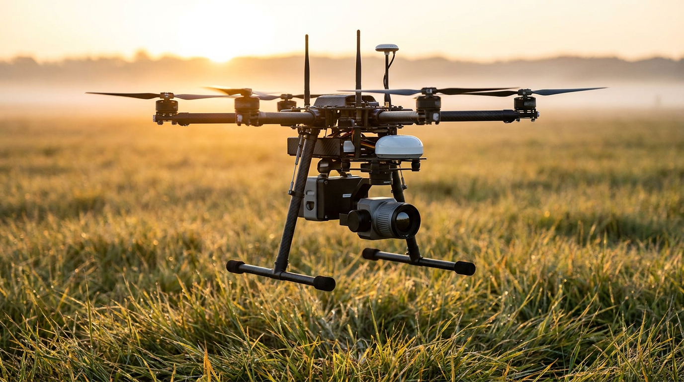
The core mechanism powering this revolution is sensor fusion. Modern demining drones are no longer limited to standard optical cameras. Instead, they carry a payload of specialized instruments, including Ground Penetrating Radar (GPR), thermal infrared sensors, and Light Detection and Ranging (LiDAR) scanners. By combining these distinct data streams, algorithms can build a comprehensive, multi-layered map of suspected hazardous areas.[4][5]

A primary claim driving recent research is that thermal imaging can successfully detect buried mines where traditional optical cameras fail. Because many modern landmines are constructed from plastic to evade metal detectors, they are virtually invisible to standard sensors once covered by soil or vegetation. However, these plastic casings possess different thermal properties than the surrounding earth.[2]
The evidence for this thermal mechanism is robust. Researchers at Waseda University, in collaboration with the International Committee of the Red Cross, demonstrated that landmines absorb and radiate solar heat at different rates than natural soil. By flying drones equipped with infrared cameras during periods of rapid temperature change—such as sunrise or sunset—the AI systems can detect the distinct thermal anomalies left by the buried explosives.[2][6]
A second major claim is that machine learning algorithms, specifically Convolutional Neural Networks (CNNs), can automate the visual identification of surface-scattered mines with high reliability. Scatterable munitions, such as the PFM-1 'butterfly' mine, are often dropped from aircraft over wide areas, making manual surveys incredibly tedious and dangerous due to their unpredictable distribution.[1][6]
Field trials provide strong support for this capability. In a comprehensive study conducted by Binghamton University, researchers trained a deep learning algorithm on thousands of images of inert PFM-1 mines. When deployed in field tests using drone-captured visual imagery, the model achieved a 91.8% accuracy rate in detecting the scatterable mines, proving that AI can rapidly process wide-area surveys much faster than human analysts.[1]

In a comprehensive study conducted by Binghamton University, researchers trained a deep learning algorithm on thousands of images of inert PFM-1 mines.
Despite these advances, a persistent challenge in demining is the false positive rate. Traditional metal detectors regularly trigger on harmless battlefield debris, such as spent bullet casings, rusty nails, or shrapnel. Every false alarm requires a deminer to halt, carefully excavate the area, and verify the object, wasting immense amounts of time and resources.[3][8]
To address this, researchers claim that integrating Ground Penetrating Radar (GPR) with AI can significantly filter out false positives. Evidence from the Ulm University of Applied Sciences (THU) supports this. By developing an autonomous sensor platform that analyzes the specific electromagnetic signatures of buried objects, researchers were able to teach the system to differentiate between the distinct shape of a landmine and random metallic clutter, drastically reducing false alarms.[3]
These academic breakthroughs are rapidly transitioning into active deployment. The Fondation suisse de déminage (FSD), a Swiss non-governmental organization, has been actively testing drone-mounted GPR and AI image processing systems in Ukraine throughout 2024 and 2025. Their field reports indicate that drones are successfully accelerating non-technical surveys, allowing teams to map hazardous zones and prioritize clearance tasks without putting boots on the ground.[5]

The software ecosystem supporting these hardware advances is also maturing. Organizations like Subsphere have developed AI-enhanced platforms, such as the 'Deminer' system, which ingest massive datasets of radar, LiDAR, and thermal imagery uploaded from the field. These machine learning models act as a force multiplier, processing terabytes of data to highlight probable mine locations for human review.[4]
The rapid scaling of this technology is supported by broader economic trends in robotics. Market analysis from Emergen Research projects that the global security and professional service robot market will grow from $51.95 billion in 2025 to nearly $270 billion by 2035. This massive influx of capital is driving down the cost of lightweight sensors and high-capacity drone batteries, making them increasingly accessible to underfunded humanitarian NGOs.[7]
However, transparent uncertainty remains regarding the technology's limitations. The evidence shows that AI detection models struggle significantly in areas with dense jungle canopies or tall grass, which obscure both visual and thermal signatures. Additionally, deeply buried anti-tank mines or those submerged in waterlogged soil can still evade current generation lightweight GPR systems mounted on drones.[1][2]

Furthermore, the 'last mile' of demining remains stubbornly physical. While drones and AI can map a minefield with unprecedented speed and accuracy, they cannot yet safely excavate and neutralize the explosives. The actual removal still requires heavily armored ground robots or highly trained human technicians to enter the danger zone and physically disarm the threat.[4]
Ultimately, the integration of AI and drone technology represents the most significant leap forward in humanitarian demining in decades. As machine learning models ingest more diverse terrain data from active deployments, their confidence scores will continue to improve. While not a silver bullet, this evidence-backed approach is systematically shifting the odds, offering a realistic pathway to reclaiming post-conflict lands in years rather than centuries.[9]
How we got here
1990s
Traditional manual demining relies almost exclusively on handheld metal detectors and physical prodding.
2010s
Early experiments begin mounting heavy Ground Penetrating Radar systems on large, armored ground vehicles.
2020
Advances in lightweight sensors allow multispectral and thermal cameras to be mounted on commercial drones for aerial surveys.
2024
Organizations like the Fondation suisse de déminage begin active field testing of AI-integrated drone radar in post-conflict zones like Ukraine.
2025
Deep learning models achieve over 90% accuracy in detecting scatterable plastic mines in academic field trials.
Viewpoints in depth
Humanitarian Demining Organizations
Focused on maximizing safety and accelerating the return of land to civilian use.
For NGOs and field operators, the primary metric of success is risk reduction. They view AI and drone technology not as an academic exercise, but as a critical force multiplier that keeps human operators out of unverified minefields. Their main priority is ensuring that these high-tech systems are rugged, affordable, and capable of operating in austere environments without reliable internet access.
AI & Robotics Researchers
Focused on algorithmic accuracy, sensor fusion, and reducing false positive rates.
The academic and engineering community is primarily concerned with the data pipeline. They argue that the hardware is already capable, but the software needs vast amounts of diverse training data to improve. Their research focuses on combining thermal, optical, and radar data to teach neural networks how to ignore battlefield clutter and identify the subtle signatures of plastic explosives under various soil conditions.
Defense Technology Analysts
Focused on market dynamics and the civilian application of military technology.
Industry analysts view the rise of AI demining as a successful spin-off of military Intelligence, Surveillance, and Reconnaissance (ISR) capabilities. They track the massive influx of capital into the autonomous security robot market, noting that economies of scale are driving down the cost of advanced sensors, which in turn makes these life-saving technologies accessible to underfunded humanitarian groups.
What we don't know
- How quickly AI models can adapt to entirely new types of improvised explosive devices (IEDs) not present in their training data.
- The exact timeline for when fully autonomous ground robots will be capable of safely excavating and neutralizing the mines mapped by drones.
Key terms
- Ground Penetrating Radar (GPR)
- A geophysical method that uses radar pulses to image the subsurface, detecting buried objects by measuring electromagnetic reflections.
- Sensor Fusion
- The process of combining data from multiple different sensors (like optical, thermal, and radar) to create a more accurate and comprehensive model of an environment.
- Convolutional Neural Network (CNN)
- A type of artificial intelligence algorithm specifically designed to analyze and identify patterns within visual imagery.
- Scatterable Munitions
- Small explosive devices, such as the PFM-1 'butterfly' mine, that are dropped from aircraft and scattered randomly over wide areas rather than being buried by hand.
- False Positive
- In demining, an instance where a sensor incorrectly identifies a harmless object (like a rusty nail) as a landmine, wasting valuable clearance time.
Frequently asked
How do drones detect buried landmines?
Drones use a combination of Ground Penetrating Radar (GPR) to scan below the surface and thermal infrared cameras to detect heat anomalies caused by plastic explosives absorbing solar radiation differently than soil.
Can AI replace human deminers entirely?
Not currently. While AI and drones can rapidly map hazardous areas and identify probable mine locations, the physical excavation and neutralization of the explosives still require human technicians or specialized ground robots.
Why are plastic landmines so difficult to find?
Modern scatterable landmines are often made of plastic to intentionally evade traditional handheld metal detectors, making them nearly invisible once covered by vegetation or soil.
What are the main limitations of drone demining?
The technology struggles in areas with dense jungle canopies that block aerial sensors, and lightweight drone-mounted radar has difficulty penetrating deeply waterlogged or highly conductive soils.
Sources
Source coverage
9 outlets
3 viewpoints surfaced


[1]Binghamton UniversityAI & Robotics Researchers
Deep Learning and Multiview-Based Detection of Scatterable PFM-1 Landmines: Performance, Out-of-Sample Evaluation, and Field Readiness
Read on Binghamton University →[2]Waseda UniversityAI & Robotics Researchers
Thermal sensing and machine learning improve accuracy of landmine detection
Read on Waseda University →[3]Aerospace & DefenceAI & Robotics Researchers
Reduction of False Alarm Rate in Landmine Detection with Ground-Penetrating Radar
Read on Aerospace & Defence →[4]SubsphereHumanitarian Demining Organizations
Drones and artificial intelligence could revolutionize humanitarian demining
Read on Subsphere →[5]Swiss Federal Department of Foreign AffairsHumanitarian Demining Organizations
Special radar built into drones
Read on Swiss Federal Department of Foreign Affairs →[6]MDPIAI & Robotics Researchers
Automated UAV-Survey System Featuring Scattered PFM-1-Type Landmines
Read on MDPI →[7]Emergen ResearchDefense Technology Analysts
Global Security Robot Market size
Read on Emergen Research →[8]ResearchGateHumanitarian Demining Organizations
Humanitarian Demining: the Problem, Difficulties, Priorities, Demining Technology and the Challenge for Robotics
Read on ResearchGate →[9]Factlen Editorial TeamDefense Technology Analysts
Synthesis by Factlen editorial team
Read on Factlen Editorial Team →
Every angle. Every day.
Get defense security stories with full source coverage and perspective breakdowns delivered to your inbox.