How LiDAR is Revealing Massive Ancient Cities Hidden in the Amazon
Airborne laser scanning is stripping away the dense rainforest canopy to uncover vast, 2,500-year-old urban networks, fundamentally rewriting the history of pre-Columbian South America.
By Factlen Editorial Team
- Field Archaeologists
- Focus on the raw data, radiocarbon dating, and structural mapping of the ruins.
- Anthropologists & Historians
- Focus on how this rewrites the human narrative and societal complexity of the Americas.
- Indigenous Heritage Advocates
- Focus on the validation of Indigenous history and the protection of the Amazon from modern development.
What's not represented
- · Modern agricultural developers in the Amazon
- · Climatologists studying ancient Amazonian rainfall
Why this matters
For centuries, the Amazon was dismissed as an untouched wilderness incapable of supporting complex societies. These discoveries restore the deep, sophisticated heritage of Indigenous Americans and fundamentally change our understanding of human history and environmental engineering.
Key points
- LiDAR technology has revealed vast, interconnected ancient cities hidden beneath the Amazon rainforest canopy.
- The Upano Valley settlements in Ecuador feature over 6,000 earthen platforms and date back 2,500 years.
- The Casarabe culture in Bolivia built 70-foot earthen pyramids and sprawling water-management systems.
- These discoveries overturn the long-held belief that the Amazon was a pristine wilderness populated only by small nomadic tribes.
For centuries, the Amazon rainforest has been viewed by outsiders as a pristine, untouched wilderness—a "green hell" where the soil was too poor and the jungle too dense to support anything more than small, nomadic bands of hunter-gatherers. This assumption shaped modern ecology, history, and anthropology, leading generations of scientists to focus their attention on the stone temples of the Maya or the mountain citadels of the Inca. The prevailing dogma insisted that the Amazon basin was simply too hostile for complex civilization. But beneath the thick, impenetrable canopy, a radically different story has been waiting to be told, one that fundamentally rewrites the history of the Americas.[1]
Over the past few years, a revolutionary remote-sensing technology has systematically dismantled the myth of the empty Amazon. By peering through the thick foliage from the sky, researchers have uncovered the sprawling remains of massive, interconnected ancient cities. These are not just scattered huts; they are highly organized urban centers complete with monumental pyramids, sophisticated water-management systems, and straight, wide highways that stretch for miles. The sheer scale of these discoveries has forced archaeologists to completely reevaluate the capacity of the rainforest to support large-scale, agrarian societies, proving that ancient Amazonians were master engineers who actively shaped their environment.[2][4]
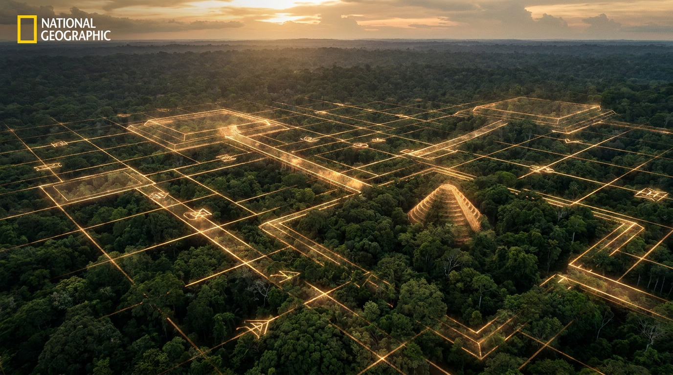
The tool driving this unprecedented paradigm shift is LiDAR, which stands for Light Detection and Ranging. Mounted on the bellies of helicopters, airplanes, or specialized drones, LiDAR systems fly over the targeted jungle and fire up to 1.5 million laser pulses per second at the ground below. While the vast majority of these pulses bounce off the dense upper canopy of the rainforest—the leaves, the thick branches, and the sprawling vines—a small fraction of the light manages to slip through the microscopic gaps in the foliage to strike the actual forest floor.[8]
By measuring exactly how long it takes for those specific pulses to reflect back to the airborne sensor, powerful computers can calculate the precise distance to the ground with millimeter accuracy. Researchers then apply advanced filtering algorithms to digitally strip away the vegetation entirely, effectively turning the jungle transparent. What is left behind is a naked, high-resolution 3D topographical map of the earth's surface, revealing unnatural geometric shapes, mounds, and causeways that have been swallowed by the jungle for centuries. This technology allows scientists to map in days what would take decades of grueling, machete-wielding expeditions on foot.[5]

"Lidar gives this magic result where you see the original landscape of the first inhabitants," Stéphen Rostain, an archaeologist and director of research at France's National Centre for Scientific Research (CNRS), recently explained. "It's a gift for an archaeologist." For researchers who spent decades walking over subtle, moss-covered mounds without realizing they were standing on ancient pyramids, the technology is akin to being handed a pair of X-ray glasses. It provides a macro-level view of the landscape, instantly connecting isolated archaeological sites into a cohesive, sprawling urban network.[7]
The results of these aerial surveys have been nothing short of staggering, fundamentally altering the timeline of South American history. In 2022, a landmark study published in the journal Nature revealed the unprecedented scale of the Casarabe culture, a society that thrived in the Llanos de Mojos region of the Bolivian Amazon between 500 and 1400 CE. Prior to this publication, the Casarabe were known only through scattered pottery shards and isolated mounds, leaving their true societal complexity a mystery. The new data proved they were a dominant, highly organized civilization.[3]
Prior to the LiDAR surveys, archaeologists knew the Casarabe built earthen mounds, but the sheer density of the jungle made it impossible to see how the various sites connected to one another. The laser scans revealed a vast, low-density urban sprawl covering roughly 4,500 square kilometers of the Bolivian savanna. Rather than living in isolated pockets, the Casarabe population was distributed across a highly integrated network of primary, secondary, and tertiary settlements, all linked together by a massive, continent-spanning infrastructure project that rivaled anything built in medieval Europe.[6]
The Casarabe did not just build villages; they engineered a highly structured, monumental civic landscape. The scans exposed stepped platforms, U-shaped ceremonial structures, and massive conical earthen pyramids towering up to 22 meters (72 feet) high above the forest floor. These monumental hubs were surrounded by ranked, concentric polygonal banks and connected by a web of raised, perfectly straight causeways stretching for miles. To support this infrastructure, they also constructed massive water-management systems, including miles of canals and deep reservoirs to control the seasonal flooding of the savanna.[3][8]
If the Casarabe discovery cracked the dogma of the pristine Amazon, a subsequent discovery in Ecuador shattered it entirely. In early 2024, Rostain and his international team of colleagues published breathtaking findings in the journal Science, detailing a 2,500-year-old network of "garden cities" in the Upano Valley, nestled deep in the eastern foothills of the Ecuadorian Andes. This discovery pushed the timeline of Amazonian urbanism back by over a thousand years, proving that complex societies were thriving in the rainforest at the exact same time the Roman Republic was expanding in Europe.[2]
If the Casarabe discovery cracked the dogma of the pristine Amazon, a subsequent discovery in Ecuador shattered it entirely.
Built and continuously occupied from roughly 500 BCE to 600 CE, the Upano Valley settlements are more than a millennium older than any other complex Amazonian society discovered to date. The LiDAR maps revealed a staggering 6,000 rectangular earthen platforms distributed across at least 15 distinct, interconnected settlements. These platforms served as the foundations for homes, civic buildings, and ceremonial plazas, all carefully arranged around central squares in a highly formalized, repetitive urban pattern that suggests a strong centralized authority.[4]

What shocked researchers most was the vast infrastructure connecting these ancient Ecuadorian settlements. The Upano people constructed a complex system of wide, straight roads that intersected at perfect right angles, deliberately ignoring the natural contours of the rugged, mountainous landscape. This required immense labor, sophisticated engineering, and centralized planning to dig through hills and fill in valleys. The road network extended for tens of kilometers, functioning as the arteries of a massive, bustling civilization that dominated the Upper Amazon for centuries.[4]
These discoveries point to a specific, highly adapted type of settlement known to archaeologists as "low-density urbanism." Unlike the densely packed, walled stone cities of the Maya in Central America or the Romans in Europe, ancient Amazonian cities were sprawling, open, and integrated intimately with agriculture. Residential neighborhoods and ceremonial centers were interspersed with vast networks of terraced fields, drainage canals, and managed forest gardens. It was a city model designed to work with the rainforest ecosystem rather than paving over it.[6]
To support populations that likely numbered in the tens or even hundreds of thousands, these ancient engineers had to solve the fundamental problem of the Amazon's notoriously nutrient-poor, acidic soil. They did so by creating terra preta, or "dark earth"—a highly fertile, human-made soil enriched with charcoal, compost, broken pottery, and animal bone. This anthropogenic soil transformed barren jungle dirt into incredibly productive farmland, allowing them to cultivate maize, squash, and sweet potatoes at a massive scale. Remarkably, this dark earth remains highly fertile today, centuries after the cities were abandoned.[1]
The implications of these LiDAR findings extend far beyond academic archaeology and historical curiosity. For decades, the narrative of a "pristine," untouched Amazon was weaponized to justify the displacement of Indigenous populations, framing them as passive, nomadic inhabitants of a wild landscape rather than the direct descendants of its original architects. By proving that the Amazon is a deeply managed, anthropogenic landscape, these discoveries provide powerful scientific backing for Indigenous land rights and cultural heritage claims across South America.[5]

"These discoveries counter the narrative that Indigenous peoples were passive inhabitants before the arrival of Europeans," noted Eduardo Neves, a prominent archaeologist at the University of São Paulo who has spent his career studying the region. "The people who lived there changed the landscape forever." The Amazon we see today is not a virgin wilderness; it is a sprawling, overgrown garden, shaped by millennia of human intervention, selective planting, and massive earthmoving projects that are only now coming to light.[1]
The sheer scale of what remains hidden beneath the canopy is tantalizing to researchers. Recent statistical models, extrapolating from the current, limited LiDAR data, suggest that between 10,000 and 24,000 pre-Columbian earthworks are still waiting to be discovered across the vast expanse of the Amazon basin. As the cost of aerial scanning drops and drone technology improves, archaeologists anticipate a "gold rush" of new discoveries over the next decade, likely revealing even larger and older civilizations hidden in the deepest parts of the jungle.[1]
Yet, despite the flood of new data, significant mysteries remain unsolved. The most pressing question is exactly why these sprawling, successful metropolises were ultimately abandoned by their builders. Radiocarbon dating shows that the Casarabe culture vanished around 1400 CE, a full century before the arrival of Europeans in the Americas. Researchers strongly suspect that shifting climate patterns, which altered the delicate balance of seasonal rainfall required to maintain their vast reservoir and canal systems, may have driven the population to disperse.[3][6]

Other Amazonian settlements likely survived well into the 15th and 16th centuries, only to be decimated by the rapid, invisible spread of European diseases like smallpox and measles. These pathogens swept through the continent's extensive Indigenous trade networks, wiping out up to 90 percent of the population long before the first Spanish or Portuguese explorers ever set foot in the deep jungle. The survivors, facing societal collapse, likely abandoned the monumental cities and adopted the nomadic lifestyles observed by later European colonists.[1]
As commercial logging, illegal mining, and mechanized agriculture continue to rapidly encroach on the Amazon rainforest, the race to document these ancient sites is accelerating. Every month, bulldozers and clear-cutting operations destroy pre-Columbian mounds, canals, and causeways that have never been studied or even mapped. LiDAR is not just rewriting history; it is providing a critical, time-sensitive tool to map and protect the cultural heritage of the Amazon before it is permanently erased by the relentless march of modern industrial development. Organizations are now using this data to lobby for protected archaeological zones.[8]
Ultimately, the revelation of these hidden cities forces us to completely reimagine the story of human civilization in the Americas. The Amazon is no longer a green void on the archaeological map, nor is it a hostile environment that prevented human progress. It is a profound testament to human ingenuity—a place where ancient societies did not merely survive the harsh realities of the jungle, but masterfully engineered it to build thriving, interconnected metropolises that stood the test of time.[1]
How we got here
500 BCE
The Upano people begin constructing complex garden cities and road networks in modern-day Ecuador.
500 CE
The Casarabe culture emerges in the Bolivian Amazon, building large stepped platforms and water-management systems.
1400 CE
The Casarabe settlements are largely abandoned, possibly due to environmental shifts.
1990s
Archaeologists begin finding isolated earthworks on foot, facing skepticism from the broader scientific community.
2022
A landmark Nature paper publishes LiDAR scans of the Bolivian Amazon, proving the existence of sprawling Casarabe urban centers.
2024
Researchers publish LiDAR data revealing the 2,500-year-old Upano Valley network, the oldest and largest Amazonian civilization found to date.
Viewpoints in depth
The Scientific & Academic Consensus
A profound paradigm shift recognizing the Amazon as a hub of ancient urbanism.
For decades, mainstream archaeology largely ignored the Amazon basin, assuming its acidic soils and harsh climate precluded the development of complex societies. The advent of LiDAR has completely overturned this dogma. Researchers now agree that pre-Columbian Amazonians were master engineers who practiced 'low-density urbanism'—building sprawling, interconnected garden cities that supported tens of thousands of people. The evidence of monumental earthworks, perfectly straight highways, and massive water-management systems proves that these societies were on par with the Maya or the ancient Egyptians in terms of civic organization and labor mobilization.
Indigenous Heritage Advocates
Viewing the discoveries as validation of deep historical roots and land rights.
For Indigenous communities and their advocates, the LiDAR discoveries are not just scientific curiosities; they are political and cultural validations. Western science is finally catching up to what oral histories have long maintained: that Indigenous peoples were not merely passive wanderers in a 'pristine' wilderness, but the original architects of the Amazon. Organizations like Amazonia Revelada are now using this same LiDAR technology to help traditional communities prove their historic presence on the land, utilizing archaeological data to ward off illegal loggers and mechanized agriculture.
What we don't know
- Exactly why the massive Casarabe and Upano Valley settlements were ultimately abandoned.
- The true population size of these ancient Amazonian cities at their peak.
- How many more thousands of undiscovered earthworks remain hidden beneath the 2.5 million square miles of the Amazon basin.
Key terms
- LiDAR
- Light Detection and Ranging; a remote sensing method that uses pulsed lasers to measure distances and generate precise 3D models of the Earth's surface.
- Low-density urbanism
- A sprawling city layout where residential areas are interspersed with large agricultural spaces, rather than being densely packed.
- Casarabe culture
- A pre-Columbian society that thrived in the Bolivian Amazon from roughly 500 to 1400 CE, known for monumental earthworks.
- Upano Valley
- A region in the eastern foothills of the Ecuadorian Andes where archaeologists recently discovered a 2,500-year-old network of interconnected garden cities.
- Terra preta
- Highly fertile, human-made 'dark earth' created by ancient Amazonians through the addition of charcoal, bone, and compost to the naturally poor rainforest soil.
Frequently asked
How does LiDAR see through the trees?
LiDAR fires millions of laser pulses per second from an aircraft. While most hit the canopy, a fraction reach the ground. Software then filters out the vegetation to reveal the bare earth.
Why were these ancient cities abandoned?
The exact reasons remain unknown, but archaeologists suspect a combination of climate shifts, changing rainfall patterns, and later, the devastating impact of European diseases.
Did these civilizations build stone pyramids like the Maya?
No, because stone is scarce in the Amazon basin. They built massive monumental architecture, including pyramids up to 70 feet tall, entirely out of earth.
Sources
Source coverage
8 outlets
3 viewpoints surfaced


[1]Factlen Editorial TeamAnthropologists & Historians
Synthesis by Factlen editorial team
Read on Factlen Editorial Team →[2]ScienceField Archaeologists
Two thousand years of garden urbanism in the Upper Amazon
Read on Science →[3]NatureField Archaeologists
Lidar reveals pre-Hispanic low-density urbanism in the Bolivian Amazon
Read on Nature →[4]Smithsonian MagazineAnthropologists & Historians
Laser Mapping Reveals the Oldest and Largest 'Garden Cities' in the Amazon
Read on Smithsonian Magazine →[5]BBC Science FocusIndigenous Heritage Advocates
The hidden ancient mega-cities of the Amazon are finally revealing their secrets
Read on BBC Science Focus →[6]Science NewsAnthropologists & Historians
Airborne lasers reveal ancient urban sprawl in the Amazon
Read on Science News →[7]CBCIndigenous Heritage Advocates
LiDAR reveals ancient cities hidden deep in the Amazon rainforest
Read on CBC →[8]German Archaeological InstituteField Archaeologists
Lidar technology reveals early urbanism in the Amazon
Read on German Archaeological Institute →


Every angle. Every day.
Get culture stories with full source coverage and perspective breakdowns delivered to your inbox.