How Commercial Satellites and Open-Source Intelligence Are Democratizing Global Security
The proliferation of commercial satellite imagery and open-source data has ended the state monopoly on military intelligence, empowering civilian analysts to deter conflict and document human rights abuses.
By Factlen Editorial Team

- Strategic Defense Analysts
- Military strategists view the commercialization of intelligence as a double-edged sword that deters surprise attacks but severely complicates operational security.
- Transparency Advocates
- NGOs and journalists argue that OSINT is the ultimate tool for accountability, making it impossible for states to hide atrocities or manipulate narratives.
- International Legal Experts
- Legal scholars warn that the rapid rise of civilian intelligence gathering outpaces existing humanitarian law, leaving independent analysts legally vulnerable.
What's not represented
- · Commercial Satellite Providers
- · Authoritarian Regimes
Why this matters
The ability to monitor military movements is no longer restricted to superpowers. This unprecedented transparency makes it vastly harder for nations to launch surprise attacks or hide human rights abuses, fundamentally shifting global power toward accountability.
Key points
- Commercial satellite imagery and open-source data have ended the state monopoly on military intelligence.
- The ability for anyone to monitor troop movements acts as a powerful deterrent against surprise military attacks.
- Human rights groups are successfully using digital transparency to document war crimes and bypass state censors.
- Synthetic Aperture Radar (SAR) allows commercial satellites to monitor the Earth 24/7, seeing through clouds and darkness.
- The rapid rise of civilian intelligence gathering has created legal ambiguities under international law.
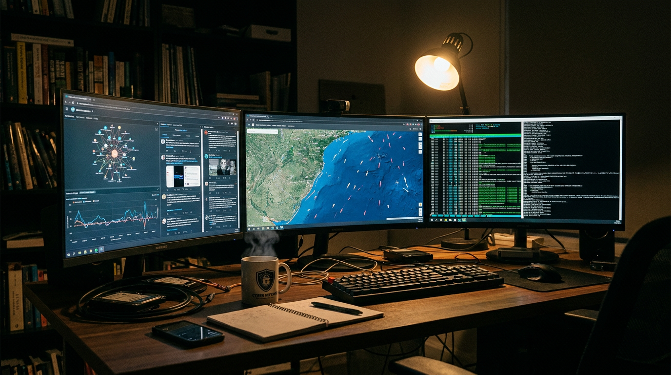
For decades, the ability to peer across sovereign borders and monitor military movements was the exclusive domain of superpowers. Developing, launching, and maintaining constellations of spy satellites required multi-billion-dollar budgets and vast state apparatuses. Today, that monopoly has permanently fractured. Anyone with an internet connection, a credit card, and analytical training can access a level of strategic visibility that would have been highly classified just twenty years ago. This structural shift is fundamentally altering the geopolitical landscape, stripping away the traditional secrecy that historically allowed conflicts to escalate in the shadows. By distributing the power of observation to journalists, non-governmental organizations, and smaller nations, the commercial intelligence market is fostering a new era of global transparency.[1][8]
This phenomenon, widely categorized by defense analysts as the "democratization of intelligence," relies on a rapidly expanding ecosystem of commercial satellite providers. Companies such as Maxar, Planet, and BlackSky have deployed hundreds of low-earth-orbit satellites that continuously photograph the globe. When fused with open-source intelligence (OSINT)—information gathered from publicly available data, social media, and academic research—these commercial images provide a near real-time picture of the battlespace. In recent conflicts, this fusion of imagery and public data has significantly reduced the traditional "fog of war," turning modern battlefields into environments where almost every major logistical movement is visible, documented, and analyzed by a global community of observers.[1][7]
The strategic implications of this transparency are profound, primarily because visibility itself has evolved into a potent weapon of deterrence. Access to high-resolution orbital imagery allows mid-tier states and even non-state actors to achieve asymmetric deterrence against technologically superior adversaries. When a nation knows its troop buildups, missile deployments, and naval movements are being watched not just by rival intelligence agencies, but by the global public, the calculus for launching a surprise attack changes dramatically. The inability to hide preparations for war raises the political and diplomatic costs of aggression, effectively leveling the playing field for nations that cannot afford their own sovereign space programs.[3]

The conflict in Ukraine served as the undeniable watershed moment for this intelligence revolution. From the earliest days of the invasion, commercial satellite imagery provided a continuous, undeniable picture of Russian troop movements, logistics hubs, and staging areas. This marked the first time in history that a major conventional war was tracked, verified, and broadcast to the world by independent civilian analysts in real-time. The sheer volume of open-source data shifted the balance of power, proving definitively that critical battlefield information can no longer be monopolized solely by state governments. Ukraine’s ability to leverage commercial space assets demonstrated that civilian technology is now a decisive factor in national survival.[7]
Beyond state-on-state deterrence, the democratization of intelligence has proven highly effective at neutralizing state propaganda and disinformation campaigns. Historically, governments operating in conflict zones could control the narrative by denying atrocities or fabricating justifications for military action. Today, independent OSINT communities use geolocation, chronolocation, and satellite data to rapidly refute official falsehoods. In conflicts ranging from the civil war in Sudan to the devastation in Gaza, civilian analysts have successfully challenged manipulated photographs, exposed the true origins of missile strikes, and provided the international community with reliable, verifiable proof of events on the ground, bypassing state censors entirely.[6]
This unprecedented digital transparency is increasingly being harnessed by human rights organizations to document war crimes and ensure long-term accountability. Because physical access to occupied or heavily contested territories is often impossible, investigators exploit the digital space to gather evidence. For example, the Netherlands-based non-profit Global Rights Compliance utilized a combination of satellite imagery and user-generated social media content to track the systematic extraction and transport of civilian grain by Russian forces in Ukraine. By layering these open-source data points, investigators can build robust legal cases for the war crime of pillage, ensuring that evidence is preserved for future international tribunals.[4]

The modern OSINT evidence pipeline relies on a sophisticated fusion of multiple data streams. Analysts do not simply look at optical photographs; they layer high-resolution imagery with Synthetic Aperture Radar (SAR) data. Unlike traditional cameras, SAR technology bounces microwave signals off the Earth's surface, allowing satellites to "see" through thick cloud cover, smoke, and total darkness. When this persistent 24/7 monitoring is cross-referenced with ground-level videos posted on platforms like Telegram or X, investigators can triangulate the exact time, location, and nature of a military event with astonishing precision, creating an evidentiary record that is incredibly difficult for state actors to dispute.[4][8]
The modern OSINT evidence pipeline relies on a sophisticated fusion of multiple data streams.
The speed and accuracy of this analysis are currently being supercharged by the integration of artificial intelligence. Machine-learning algorithms can now process terabytes of satellite data in minutes, automatically detecting changes in terrain, identifying specific types of military hardware, and assessing battle damage across vast geographic areas. Tasks that previously required rooms full of highly trained military intelligence officers poring over photographs can now be executed by civilian software. This AI-assisted fusion allows OSINT communities to monitor missile launches and troop movements in near real-time, further eroding the informational advantage traditionally held by advanced militaries.[8]
For middle powers and developing nations, the commercial intelligence market offers a highly cost-effective alternative to the decades-long process of building a sovereign space program. By simply purchasing commercial satellite subscriptions and training domestic analysts in OSINT methodologies, smaller nations can develop a comprehensive and accurate picture of their regional security environment. This dynamic fundamentally alters regional power balances, as states with limited conventional military forces can now afford the strategic foresight necessary to anticipate and counter threats from larger, better-equipped neighbors, democratizing a capability that was once the ultimate luxury of superpowers.[1][3]

This shift is particularly evident in regions characterized by dense critical infrastructure and asymmetric tensions, such as the Middle East. Open-source satellite imagery has made the exact layouts of military bases, border posts, energy facilities, and ports visible to a wide array of actors, including journalists and non-state groups. This widespread visibility forces governments to fundamentally rethink how they manage the strategic exposure of their assets. Because adversaries can now monitor infrastructure without relying on vulnerable human intelligence networks on the ground, states must operate under the assumption of persistent, unblinking surveillance.[2]
Despite its immense benefits for transparency, the democratization of intelligence carries significant uncertainties and risks, particularly regarding the integrity of the data itself. The same artificial intelligence tools that enhance geolocation and image analysis can also be weaponized to generate deepfakes and synthetic media. As generative AI becomes more sophisticated, there is a growing risk that malicious actors could flood the open-source ecosystem with highly realistic, fabricated evidence of troop movements or atrocities. While OSINT communities currently rely on rigorous cross-verification to weed out fakes, the escalating arms race between digital forensics and synthetic media remains a critical vulnerability.[4]
Furthermore, the rapid rise of civilian intelligence gathering has outpaced the development of international legal frameworks. The legal status of civilian OSINT analysts operating in or monitoring conflict zones remains highly ambiguous under International Humanitarian Law (IHL). The International Committee of the Red Cross has noted that while imposing onerous legal obligations on non-state actors could chill positive investigatory work, the current absence of a clear framework leaves civilian analysts operating in a gray zone. Without harmonized codes of conduct, independent investigators face potential legal liabilities, and the evidence they gather risks being excluded from formal criminal proceedings.[5]

Civilian investigators also face systemic vulnerabilities related to the corporate policies of the platforms they rely on. Social media companies frequently deploy automated moderation tools to remove content deemed to be terrorist propaganda or graphic violence. However, this aggressive moderation often has the unintended consequence of permanently deleting raw, ground-level footage that is crucial for open-source war crime investigations and judicial fact-checking. When vital digital evidence is erased by algorithmic bias or corporate mandate before it can be archived by human rights groups, the chain of accountability is broken, highlighting the fragility of relying on commercial platforms for global justice.[8]
Despite these challenges, the trajectory of global security is clear: the window for covert military action is rapidly and permanently closing. As commercial satellite constellations grow denser and revisit rates drop from days to hours, militaries worldwide are being forced to adapt to an environment of persistent observation. Traditional doctrines relying on camouflage, concealment, and operational surprise are becoming increasingly obsolete in an era where the sky is filled with commercial sensors. The ability to hide large-scale military maneuvers is vanishing, forcing a recalibration of strategic planning across all major alliances.[3][7]
Ultimately, the rise of open-source intelligence and commercial satellite imagery represents one of the most significant structural shifts in modern international relations. By distributing the power of observation away from a handful of secretive state agencies and into the hands of a global, interconnected civilian community, the intelligence revolution is fostering a more transparent world. While this new reality introduces complex challenges regarding data verification and legal protections, the overarching result is profoundly positive: a global security environment where aggression is harder to hide, state propaganda is easier to debunk, and accountability is increasingly crowd-sourced.[1][8]
How we got here
2014–2017
Early OSINT communities begin using social media to track the Syrian civil war and the downing of MH17.
2019
Commercial satellite companies begin launching large constellations of low-earth-orbit imaging satellites.
Feb 2022
Commercial satellite imagery publicly reveals the Russian military buildup on Ukraine's border, stripping away the element of surprise.
2023–2024
Human rights organizations formalize the use of OSINT to submit evidence of war crimes to international courts.
2025–2026
AI integration allows civilian analysts to process terabytes of satellite data in near real-time, matching state-level capabilities.
Viewpoints in depth
Transparency Advocates
NGOs and journalists argue that OSINT is the ultimate tool for accountability.
For civil society organizations and investigative journalists, the democratization of intelligence is a profound victory for human rights. They argue that OSINT strips away the plausible deniability that authoritarian regimes have historically relied upon to commit atrocities in secret. By crowd-sourcing the verification of events, transparency advocates believe that commercial satellites make it impossible for state propaganda to survive contact with verifiable, open-source reality.
Strategic Defense Analysts
Military strategists view the commercialization of intelligence as a double-edged sword.
Defense analysts acknowledge that while OSINT deters surprise attacks, it also severely complicates operational security for all nations, including democracies. They point out that the same commercial satellites that expose war crimes can also be purchased by hostile non-state actors to monitor the movements of peacekeeping forces or target critical infrastructure. For strategists, the challenge is learning how to conduct necessary military operations in an era where the sky is constantly watching.
International Legal Experts
Legal scholars warn that civilian intelligence gathering outpaces existing humanitarian law.
Experts in International Humanitarian Law express deep concern over the legal gray zone inhabited by civilian OSINT analysts. They argue that because these individuals are actively participating in the gathering of conflict intelligence, their protected status as civilians could theoretically be challenged by belligerent states. Furthermore, legal scholars worry that without standardized evidentiary protocols, the massive volume of digital evidence gathered by NGOs may ultimately be deemed inadmissible in formal war crime tribunals.
What we don't know
- How international courts will ultimately standardize the admissibility of crowd-sourced digital evidence in war crime tribunals.
- Whether the rapid advancement of AI-generated deepfakes will eventually outpace the forensic tools used by OSINT analysts to verify imagery.
- How authoritarian regimes might attempt to physically or cybernetically disrupt commercial satellite constellations during future conflicts.
Key terms
- Open-Source Intelligence (OSINT)
- Intelligence derived from publicly available data, such as commercial satellite imagery, social media, and public records, rather than classified espionage.
- Synthetic Aperture Radar (SAR)
- A form of radar used by satellites to create two-dimensional images or three-dimensional reconstructions of landscapes, capable of penetrating clouds and darkness.
- Geolocation
- The process of identifying the real-world geographic location of an object or event shown in a photograph or video by matching landmarks to satellite maps.
- Asymmetric Deterrence
- A strategy where a weaker power uses unconventional means—in this case, public transparency and observation—to deter a technologically superior adversary.
- International Humanitarian Law (IHL)
- A set of rules which seek, for humanitarian reasons, to limit the effects of armed conflict, protecting those who are not participating in hostilities.
Frequently asked
What is Open-Source Intelligence (OSINT)?
OSINT is the collection and analysis of information gathered from publicly available sources, including commercial satellite imagery, social media posts, academic research, and public government records.
How do commercial satellites differ from military spy satellites?
While top-tier military satellites still possess the highest resolution capabilities, commercial satellites are now advanced enough to identify vehicles, infrastructure changes, and troop movements, and their imagery can be purchased by anyone.
Can AI fake satellite imagery?
Yes, generative AI can create highly realistic synthetic media and deepfakes. OSINT analysts combat this by cross-referencing multiple data streams, such as matching satellite photos with ground-level video and radar data.
How does OSINT help prosecute war crimes?
Human rights organizations use OSINT to document atrocities in areas they cannot physically access, preserving digital evidence like geolocation data and satellite imagery for future use in international tribunals.
Sources
Source coverage
8 outlets
3 viewpoints surfaced


[1]Atlantic CouncilStrategic Defense Analysts
The democratization of intelligence and spacepower
Read on Atlantic Council →[2]Middle East CouncilStrategic Defense Analysts
OSINT and the Changing Intelligence Landscape
Read on Middle East Council →[3]Global GeopoliticsStrategic Defense Analysts
Visibility Itself Has Become a Strategic Weapon
Read on Global Geopolitics →[4]Context NewsTransparency Advocates
Ukraine conflict: How can open-source intelligence help prove war crimes?
Read on Context News →[5]ICRCInternational Legal Experts
The deployment of open-source intelligence in armed conflict
Read on ICRC →[6]The Source NewsTransparency Advocates
A new lens on warfare through OSINT
Read on The Source News →[7]Diplomat MagazineStrategic Defense Analysts
The decisive role of intelligence fusion: HUMINT, SIGINT, OSINT, and IMINT
Read on Diplomat Magazine →[8]Factlen Editorial TeamInternational Legal Experts
Synthesis by Factlen editorial team
Read on Factlen Editorial Team →
Every angle. Every day.
Get defense security stories with full source coverage and perspective breakdowns delivered to your inbox.