How Ancient Polynesian Navigators Mapped the Pacific Without Instruments
For thousands of years, Polynesian wayfinders used the stars, ocean swells, and bird flight patterns to intentionally navigate across the vast Pacific Ocean. After the knowledge was nearly lost, a 1976 voyage on a traditional double-hulled canoe sparked a cultural renaissance that proved the genius of ancient seafaring.
By Factlen Editorial Team
- Traditional Wayfinders
- View navigation as a holistic, spiritual practice requiring deep intuition and a lifelong observational relationship with the natural world.
- Experimental Archaeologists
- Focus on rigorously testing ancient technologies to prove that intentional, two-way voyaging was scientifically and practically possible.
- Indigenous Cultural Advocates
- See the revival of voyaging as a crucial catalyst for reclaiming historical pride, language, and sovereignty after centuries of colonization.
What's not represented
- · Academic skeptics of intentional voyaging (historical view)
- · Modern maritime regulatory bodies
Why this matters
The revival of Polynesian wayfinding is not just a triumph of experimental archaeology; it is a profound reclamation of indigenous knowledge. It proves that ancient Pacific Islanders were not passive drifters, but master scientists and intentional explorers who engineered one of the greatest human migrations in history.
Key points
- Ancient Polynesians navigated the Pacific using a complex system of celestial and environmental observation.
- Master navigators memorized the rising and setting points of over 150 stars to maintain precise headings.
- The knowledge of traditional wayfinding was nearly lost due to centuries of Western colonization.
- In 1976, the double-hulled canoe Hōkūleʻa sailed 2,700 miles without modern instruments to prove the efficacy of ancient methods.
- Micronesian master navigator Mau Piailug shared his sacred knowledge, sparking a massive cultural renaissance across the Pacific.
For decades, Western historians and anthropologists debated how ancient people populated the remote islands of the Pacific. Some prominent theorists, most notably Thor Heyerdahl, argued that the islands were settled by accidental drift—that early mariners were simply blown off course by prevailing winds and currents. This theory assumed that without modern instruments like compasses, sextants, or chronometers, intentional two-way navigation across thousands of miles of open ocean was impossible. But the oral traditions of Pacific Islanders told a very different story: one of deliberate exploration, sophisticated vessels, and master navigators who could read the natural world like a map.[2][3]
The reality of Polynesian expansion is one of the greatest feats of human migration in history. Using outrigger and double-hulled canoes, ancient Polynesians made contact with nearly every habitable island within the vast Polynesian Triangle—a massive expanse of ocean anchored by Hawaiʻi in the north, New Zealand (Aotearoa) in the southwest, and Easter Island (Rapa Nui) in the east. These voyages were not random. When resources on a home island ran low, or when political disputes arose, communities would provision large double-hulled canoes with food, water, and agricultural staples, setting sail with the explicit intention of finding and colonizing new lands.[3][4]
To accomplish this, they relied on a highly sophisticated system of non-instrument navigation known as wayfinding. At the core of this system is the star compass, a mental construct that divides the horizon into 32 distinct segments. Unlike a magnetic compass that points to a physical north, the star compass is based on the rising and setting points of celestial bodies. A master navigator must memorize the specific paths of over 150 stars. As the night progresses and the Earth rotates, new stars rise in the east and set in the west, providing a continuous, rotating bearing. By aligning the canoe with these celestial markers, a wayfinder can maintain a precise heading across thousands of miles of featureless ocean.[3][5]

But the sky is only one part of the navigational toolkit; a wayfinder must also read the ocean itself. When clouds obscure the stars, navigators rely on the complex patterns of ocean swells. Unlike surface waves generated by local winds, swells are deep, rolling waves created by distant storms, and they move in consistent directions for days at a time. An experienced navigator can feel up to four or five different swell patterns simultaneously through the hull of the canoe. By understanding how these swells interact with the prevailing trade winds, the navigator can maintain the vessel's orientation entirely by the physical sensation of the ocean's rhythm.[3][5]
As a canoe approaches land, the ocean provides even more specific clues. Islands disrupt the steady march of ocean swells, causing them to refract and bounce back. A master wayfinder can detect these subtle interference patterns miles before the land itself is visible, effectively feeling the "shadow" of an island in the water. Furthermore, the color of the water changes, and the undersides of clouds can reflect the bright turquoise of a shallow coral lagoon, projecting a map of the atoll into the sky.[3][5]
Biological markers serve as the final homing beacons. Navigators closely observe the flight paths of specific seabirds, such as the white tern or the noddy tern, which fly out to sea in the morning to fish and return to land at dusk. Following their evening trajectory points directly to shore. Migratory birds, like the long-tailed cuckoo, also provide seasonal directional cues. Even the water itself glows with information; specific patterns of bioluminescence, flashing in the wake of the canoe, can indicate the presence of underwater reefs or the proximity of a coastline.[3][5]

Following their evening trajectory points directly to shore.
Despite the brilliance of this system, the art of wayfinding was nearly extinguished. Centuries of Western colonization, the introduction of modern navigational tools, and the suppression of indigenous cultures led to a catastrophic loss of traditional knowledge. By the mid-20th century, the practice of long-distance, non-instrument navigation had completely died out in Polynesia. In Hawaiʻi, it had been over 600 years since a traditional double-hulled voyaging canoe had even been constructed. The ancient routes were closed, and the legacy of the master navigators was fading into myth.[4][6]
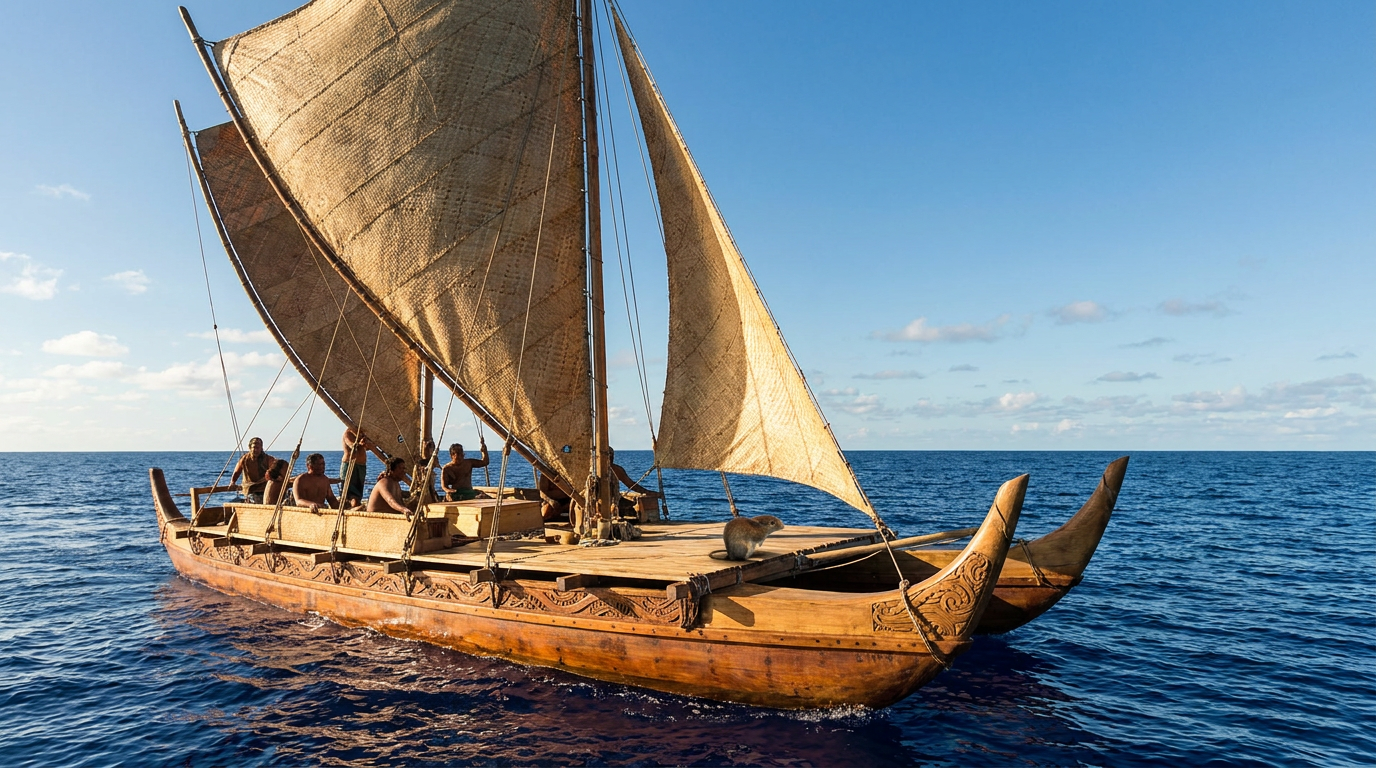
The turning point arrived in 1973 with the founding of the Polynesian Voyaging Society (PVS) in Honolulu. Anthropologist Ben Finney, Hawaiian artist Herb Kawainui Kane, and sailor Tommy Holmes joined forces with a singular, ambitious goal: to prove that intentional, two-way voyaging was historically accurate. To do this, they initiated an audacious project of experimental archaeology. They designed and built the Hōkūleʻa, a 62-foot performance-accurate replica of a traditional Hawaiian double-hulled voyaging canoe. The plan was to sail the vessel from Hawaiʻi to Tahiti—a 2,700-mile journey—using only traditional wayfinding techniques.[1][2]

The project immediately hit a critical roadblock: there was no one left in Hawaiʻi who knew how to navigate without instruments. The PVS searched desperately across the Pacific for a surviving master. They eventually found their savior on the tiny Micronesian island of Satawal. Pius "Mau" Piailug was a master navigator, or "pwo," who had been trained in the ancient Weriyeng school of navigation since he was five years old. Concerned that his own people were losing their traditions to Western acculturation, Mau made the unprecedented decision to break with the strict secrecy of his guild and share his sacred knowledge with the Hawaiians.[2][6]
On May 1, 1976, the Hōkūleʻa departed Hawaiʻi for Tahiti. Mau Piailug stood on the deck, guiding the vessel without a compass, sextant, or map. For over a month, he stayed awake for most of the journey, constantly processing the data of the natural world—the arc of the stars, the pitch of the swells, the direction of the wind. The crew endured fierce storms, doldrums, and the immense psychological pressure of the open ocean, placing their absolute trust in Mau's mental map and his deep, intuitive connection to the sea.[1][4]
On June 3, 1976, the Hōkūleʻa arrived triumphantly at the beach in Papeʻete Harbor, Tahiti. The sight that greeted them was staggering: over 17,000 Tahitians—more than half the island's population—had gathered on the shore to welcome the canoe. The successful voyage definitively silenced the academic skeptics, proving beyond a doubt that ancient Polynesians were capable of intentional, precision navigation across thousands of miles. But more importantly, it triggered a massive cultural awakening.[1][2]

The voyage of the Hōkūleʻa is widely credited with helping to kickstart the Hawaiian Renaissance, a powerful resurgence of indigenous pride, language, and cultural practices that had been suppressed for generations. The canoe became a floating symbol of survival and capability. Following the 1976 voyage, Mau Piailug dedicated himself to training a new generation of navigators, most notably a young Hawaiian named Nainoa Thompson. Under Mau's mentorship, Thompson became the first Native Hawaiian in centuries to master the art of wayfinding, eventually leading the Hōkūleʻa on a return voyage to Tahiti in 1980.[4][6]
Today, the legacy of Mau Piailug and the Hōkūleʻa extends far beyond Hawaiʻi. The revival of wayfinding has spread throughout the Pacific, inspiring the construction of new voyaging canoes in New Zealand, the Cook Islands, and beyond. The Hōkūleʻa itself has sailed over 140,000 nautical miles, completing a multi-year circumnavigation of the globe to promote environmental stewardship and indigenous knowledge. Through the preservation of the star compass and the reading of the swells, modern wayfinders ensure that the genius of their ancestors remains a living, breathing science, proving that as long as one knows how to read the earth and sky, they are never truly lost.[1][5]
How we got here
Pre-European Contact
Polynesian navigators settle the vast Pacific Triangle using non-instrument wayfinding.
Mid-20th Century
Traditional long-distance navigation is nearly extinct across Polynesia due to colonization.
1973
The Polynesian Voyaging Society is founded to prove the historical reality of intentional voyaging.
March 1975
The Hōkūleʻa, a performance-accurate double-hulled voyaging canoe, is launched in Hawaiʻi.
June 1976
Guided by Mau Piailug, the Hōkūleʻa arrives in Tahiti after a 2,700-mile voyage without instruments.
1980
Nainoa Thompson becomes the first Native Hawaiian in centuries to navigate a canoe to Tahiti.
Viewpoints in depth
Traditional Wayfinders
Navigation is a holistic, spiritual practice requiring deep intuition and a lifelong observational relationship with the natural world.
For traditional wayfinders, the ocean is not an empty void to be crossed, but a rich, three-dimensional landscape filled with signs. The practice requires a profound spiritual and physical connection to the environment, often cultivated from early childhood. Navigators do not merely calculate their position; they internalize the rhythm of the swells, the temperature of the wind, and the behavior of marine life. This perspective emphasizes that wayfinding is as much a spiritual discipline and a way of life as it is a technical skill, requiring immense discipline, memory, and respect for the natural world.
Experimental Archaeologists
Focus on rigorously testing ancient technologies to prove that intentional, two-way voyaging was scientifically and practically possible.
Experimental archaeologists approach the history of Polynesian expansion through the lens of rigorous, real-world testing. Frustrated by mid-20th-century theories that dismissed indigenous achievements as accidental drift, these researchers set out to prove the efficacy of ancient methods by recreating them. By building performance-accurate vessels like the Hōkūleʻa and sailing them on historical routes without modern instruments, they provided irrefutable empirical evidence that ancient Polynesians possessed the technological and navigational sophistication required for intentional, long-distance colonization.
Indigenous Cultural Advocates
See the revival of voyaging as a crucial catalyst for reclaiming historical pride, language, and sovereignty after centuries of colonization.
For cultural advocates, the revival of wayfinding is about much more than historical accuracy; it is a vital tool for decolonization. Centuries of Western influence had actively suppressed indigenous languages, arts, and maritime traditions, leading to a profound sense of cultural loss. The successful voyages of the Hōkūleʻa served as a powerful symbol of indigenous capability and resilience. This perspective highlights how the return to the ocean sparked a broader cultural renaissance, inspiring new generations to reclaim their heritage, revitalize their languages, and assert their identity on the global stage.
What we don't know
- The exact timeline and specific routes of the earliest Polynesian migrations remain a subject of ongoing archaeological research.
- Much of the highly localized navigational knowledge for specific island chains was permanently lost before it could be recorded.
Key terms
- Wayfinding
- The traditional art of navigating open ocean without modern instruments, relying entirely on natural signs.
- Star compass
- A mental construct used by navigators that divides the horizon into segments based on the rising and setting points of stars.
- Waʻa kaulua
- A traditional Polynesian double-hulled voyaging canoe, designed for stability and cargo capacity on long ocean journeys.
- Pwo
- A sacred title given to a master navigator in the Micronesian tradition, signifying both technical mastery and spiritual leadership.
- Polynesian Triangle
- A vast region of the Pacific Ocean anchored by Hawaiʻi, New Zealand (Aotearoa), and Easter Island (Rapa Nui).
Frequently asked
Did ancient Polynesians use maps or compasses?
No. They relied entirely on a mental star compass and direct observation of the ocean, weather, and wildlife to navigate.
How did they know they were getting close to land?
Navigators looked for specific signs like the flight paths of coastal birds, wave refraction patterns, and the reflection of shallow lagoons on the undersides of clouds.
Who was Mau Piailug?
He was a master navigator from Micronesia who broke with tradition to teach Hawaiians the ancient art of wayfinding, saving it from extinction.
What is the Hōkūleʻa?
It is a modern, performance-accurate replica of a traditional Hawaiian double-hulled voyaging canoe, launched in 1975.
Sources
Source coverage
7 outlets
3 viewpoints surfaced


[1]Polynesian Voyaging SocietyExperimental Archaeologists
The Story of Hōkūleʻa
Read on Polynesian Voyaging Society →[2]Wikipedia - HōkūleʻaExperimental Archaeologists
Hōkūleʻa
Read on Wikipedia - Hōkūleʻa →Polynesian navigation
Read on Wikipedia - Polynesian Navigation →[4]The Age of ExplorationIndigenous Cultural Advocates
The 1976 journey of the voyaging canoe Hokule'a
Read on The Age of Exploration →[5]ExploratoriumTraditional Wayfinders
Polynesian Navigation
Read on Exploratorium →[6]Kamehameha SchoolsTraditional Wayfinders
Pacific Conversations: Papa Mau Piailug and the pwo navigators of Micronesia
Read on Kamehameha Schools →[7]Factlen Editorial TeamIndigenous Cultural Advocates
Synthesis by Factlen editorial team
Read on Factlen Editorial Team →
Every angle. Every day.
Get culture stories with full source coverage and perspective breakdowns delivered to your inbox.