How Ancient Polynesian Navigators Mapped the Pacific Without Instruments
Centuries before European explorers, Polynesian wayfinders successfully navigated millions of square miles of open ocean using a sophisticated system of environmental observation. By reading the stars, ocean swells, and flight paths of birds, these master navigators connected a vast network of island nations.
By Factlen Editorial Team
- Indigenous Knowledge Keepers
- View wayfinding as a holistic, living tradition that deeply connects the navigator to their ancestors, the environment, and their cultural identity.
- Anthropologists & Historians
- Focus on the empirical validation of the methods, recognizing wayfinding as a highly sophisticated form of applied science that disproves colonial theories of accidental settlement.
- Cognitive Scientists
- Study the mental star compass and swell reading to understand the extreme limits of human spatial reasoning and memory without technological aids.
- Factlen Synthesis
- Highlights the intersection of ancient wisdom and modern scientific validation, framing the revival as a triumph of human capability.
What's not represented
- · Early European explorers who fundamentally misunderstood the technology
Why this matters
Understanding wayfinding dismantles long-held colonial myths about indigenous capabilities and offers a masterclass in human cognitive potential. It demonstrates how deep, empirical observation of nature can solve complex mathematical and spatial problems without modern technology.
Key points
- Ancient Polynesians settled a ten-million-square-mile ocean region entirely without modern navigational instruments.
- Wayfinders use a mental 'star compass' to track the rising and setting points of hundreds of celestial bodies.
- During the day or under cloud cover, navigators maintain their heading by feeling the kinetic energy of deep-ocean swells.
- Biological markers, such as the daily flight paths of specific seabirds, are used to pinpoint landmasses hidden over the horizon.
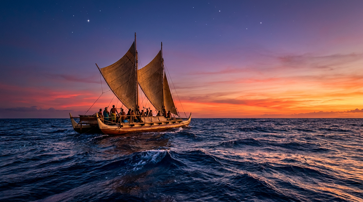
- The 1976 voyage of the Hōkūleʻa proved the efficacy of these methods, dismantling the colonial theory of 'accidental drift' settlement.
The Pacific Ocean covers more than 30 percent of the Earth's surface, a vast expanse of deep blue water larger than all of the planet's landmasses combined. For centuries, Western historians and explorers assumed that the islands scattered across this immense void were settled by accidental drift—that early peoples were simply blown off course and washed ashore by chance. This theory of accidental settlement dominated academic thought well into the 20th century, fundamentally underestimating the capabilities of indigenous maritime cultures.[2][6]
The reality, preserved in oral traditions and now exhaustively validated by modern anthropology and cognitive science, is far more remarkable. The ancestors of modern Polynesians were the greatest open-ocean voyagers in human history. Using a highly sophisticated, instrument-free system of navigation known as wayfinding, they intentionally explored and settled a ten-million-square-mile region known as the Polynesian Triangle, stretching from Hawaii in the north to Rapa Nui (Easter Island) in the east and Aotearoa (New Zealand) in the southwest.[1][3][6]
Wayfinding is not a single technique, but a complex, integrated system of applied environmental mathematics. The navigator, or 'wayfinder,' must process thousands of data points simultaneously, maintaining a continuous mental dead-reckoning of the canoe's position relative to its starting point and destination. This requires staying awake for days at a time, constantly observing the sky, the sea, and the surrounding biosphere.[1][4]
At the heart of this system is the star compass. Unlike a Western magnetic compass, which points to a physical location (magnetic north), the Polynesian star compass is an entirely mental construct. The navigator memorizes the exact rising and setting points of hundreds of specific stars along the horizon. By aligning the canoe with these celestial markers as they arc across the night sky, the wayfinder can maintain a precise heading across thousands of miles of featureless ocean.[1][5]

The mental discipline required for the star compass is staggering. The sky is divided into 32 distinct 'houses' or sectors. Because stars rise four minutes earlier each night due to the Earth's orbit, the navigator must know exactly which stars will be visible in which houses at any given time of year. When clouds obscure the primary guiding star, the wayfinder must instantly pivot to secondary or tertiary stars in adjacent houses to maintain the bearing.[4][5]
But stars are only visible at night, and the Pacific is frequently blanketed by heavy cloud cover. To maintain their heading during the day, or under overcast skies, wayfinders read the ocean itself. This is perhaps the most difficult aspect of the art to master: swell navigation. Swells are not local wind waves; they are deep, long-lasting energy waves generated by distant storms, sometimes thousands of miles away.[1][3]
A master navigator can feel the direction and rhythm of up to four or five distinct swell patterns simultaneously as they lift and roll beneath the hulls of the canoe. By memorizing the dominant swell directions before departing, the navigator can use the angle at which these swells strike the canoe to maintain a steady course, even in pitch blackness or blinding rain. It requires an intimate, almost tactile understanding of the sea's kinetic energy.[1][4][6]

A master navigator can feel the direction and rhythm of up to four or five distinct swell patterns simultaneously as they lift and roll beneath the hulls of the canoe.
Swells also serve as a long-range radar for detecting invisible landmasses. When a deep-ocean swell strikes an island, it reflects back and refracts around the landmass, creating a distinct interference pattern in the water. A skilled wayfinder can detect these subtle changes in the wave rhythm—a phenomenon known as 'wave shadowing'—up to 50 miles away from an island, long before it is visible over the horizon.[3][4]
As the canoe approaches within a hundred miles of land, biological markers become the primary instruments. The flight patterns of specific seabirds are crucial indicators. Birds like the white tern (manu-o-Kū) and the noddy (noio) fly out to sea in the morning to fish and return to land at night. By noting the direction of their flight at dawn and dusk, navigators can pinpoint the exact bearing of an island that is still hidden beyond the curvature of the Earth.[1][2]
Wayfinders also read the clouds and the water itself. High islands push air upward, creating stationary cloud formations that hover over the land even as the surrounding weather moves. The undersides of these clouds often reflect the green of lush forests or the turquoise of shallow lagoons. At night, navigators watch for deep-water bioluminescence, which flashes in specific patterns when disturbed by the backwash of waves bouncing off a distant reef.[2][3]

Tragically, much of this profound scientific knowledge was nearly lost following European contact, colonization, and the introduction of modern navigational tools. The oral traditions were suppressed, and the construction of traditional double-hulled voyaging canoes was largely abandoned. By the mid-20th century, only a handful of elders in isolated Micronesian islands still possessed the complete, unbroken knowledge of deep-sea wayfinding.[1][2][6]
The turning point came in the 1970s with the founding of the Polynesian Voyaging Society in Hawaii. Determined to prove that their ancestors were intentional explorers, a group of Hawaiians built the Hōkūleʻa, a traditional double-hulled voyaging canoe. Because the knowledge of wayfinding had been lost in Hawaii, they sought out Mau Piailug, a master navigator from the Micronesian island of Satawal, to teach them the ancient arts.[1][2]
In 1976, Mau Piailug successfully navigated the Hōkūleʻa from Hawaii to Tahiti—a journey of over 2,500 miles—using absolutely no modern instruments. He relied entirely on the stars, the swells, and the birds. This historic voyage shattered the 'accidental drift' theory forever and sparked a massive cultural renaissance across the Pacific, inspiring a new generation of indigenous navigators to reclaim their heritage.[1][3][6]

Today, this ancient science is no longer viewed by academics as a mere historical curiosity, but as a highly sophisticated system of empirical science. Modern computer modeling and decades of successful contemporary voyages have proven the extreme accuracy of the star compass and swell reading. Universities now study wayfinding to understand human cognitive mapping and spatial reasoning.[4][5]
The revival of wayfinding represents more than just the recovery of a lost technology; it is a testament to the human capacity to understand and harmonize with the natural world. In an era increasingly defined by digital reliance, the Polynesian wayfinders remind us that the human mind, when deeply attuned to its environment, is capable of navigating the most formidable frontiers on Earth.[2][6]
How we got here
1500 BCE
The Lapita people, ancestors of the Polynesians, begin expanding into the remote Pacific, settling Fiji, Tonga, and Samoa.
400–1000 CE
Master wayfinders successfully navigate to and settle the Hawaiian Islands, thousands of miles from their origin.
1200 CE
Polynesian voyagers discover and settle Aotearoa (New Zealand), completing the expansion of the Polynesian Triangle.
18th–19th Century
European colonization and the introduction of modern compasses lead to a severe decline in traditional wayfinding knowledge.
1973
The Polynesian Voyaging Society is founded in Hawaii to research and revive traditional canoe building and navigation.
1976
Master navigator Mau Piailug guides the Hōkūleʻa from Hawaii to Tahiti using only traditional wayfinding, proving the ancient methods work.
Viewpoints in depth
Indigenous Knowledge Keepers
View wayfinding as a holistic, living tradition that deeply connects the navigator to their ancestors and the environment.
For indigenous practitioners, wayfinding is not merely a mechanical process of getting from point A to point B; it is a profound spiritual and cultural discipline. The knowledge is passed down through rigorous oral tradition, requiring years of dedicated apprenticeship. Navigators emphasize that the canoe is not moving over the ocean, but rather the navigator remains stationary while using their mind to 'pull' the destination island toward them. This perspective frames the ocean not as an empty void to be conquered, but as a rich, communicative environment that provides all the necessary information for survival if one knows how to listen.
Anthropologists & Historians
Focus on the empirical validation of the methods, recognizing wayfinding as a highly sophisticated form of applied science.
Modern historians and anthropologists view the revival of wayfinding as a critical corrective to centuries of Eurocentric bias. For decades, Western academics argued that indigenous peoples lacked the technological capability for intentional, two-way voyages across thousands of miles of open ocean, insisting that the islands must have been settled by accidental drift. The documented successes of the Hōkūleʻa and subsequent voyaging canoes have forced a complete rewrite of Pacific history. Academics now study wayfinding as a premier example of indigenous science—a system based on rigorous empirical observation, hypothesis testing, and generational data collection that is entirely distinct from, yet equally valid to, Western scientific methods.
Cognitive Scientists
Study the mental star compass and swell reading to understand the extreme limits of human spatial reasoning.
Researchers in cognitive science and psychology are fascinated by the mental architecture required for wayfinding. The ability to maintain a continuous, accurate dead-reckoning position over several weeks without writing anything down pushes the known limits of human working memory and spatial cognition. Scientists study how wayfinders encode complex astronomical and oceanographic data into easily retrievable mental models, such as the star compass. This research provides valuable insights into neuroplasticity and how the human brain can adapt to process massive amounts of environmental data when technological aids are removed.
What we don't know
- The exact origins and initial departure points of the very first Lapita voyagers who began the Pacific expansion.
- How specific micro-navigation techniques and star compass variations differed between highly isolated island groups before European contact.
- The full extent of pre-Columbian contact between Polynesian wayfinders and the indigenous peoples of South America, though genetic and agricultural evidence suggests it occurred.
Key terms
- Wayfinding
- The ancient art of navigating the open ocean without instruments, using only observation of the stars, sun, ocean swells, and wildlife.
- Star Compass
- A mental construct used by navigators that divides the horizon into 32 houses, based on the rising and setting points of specific stars.
- Dead Reckoning
- The process of calculating one's current position by using a previously determined position and advancing that position based upon known or estimated speeds over elapsed time and course.
- Hōkūleʻa
- A performance-accurate full-scale replica of a traditional Polynesian double-hulled voyaging canoe, launched in Hawaii in 1975 to revive the art of wayfinding.
- Polynesian Triangle
- A vast region of the Pacific Ocean anchored by Hawaii in the north, New Zealand in the southwest, and Easter Island in the east.
Frequently asked
Did Polynesian navigators use maps or charts?
No. The entire navigational system, including the star compass and the locations of hundreds of islands, was memorized and passed down through oral tradition and practical apprenticeship.
How did they survive storms on the open ocean?
Traditional double-hulled canoes are incredibly resilient and designed to flex with the waves. During severe storms, navigators would lower the sails and use sea anchors to keep the bow pointed into the wind, riding out the weather until the sky cleared.
How did they carry enough food and water?
Voyagers carried preserved foods like dried fish, fermented breadfruit, and coconuts, which provided both food and sterile water. They also caught fresh fish and collected rainwater using the canoe's sails during the journey.
Is wayfinding still practiced today?
Yes. Following the successful 1976 voyage of the Hōkūleʻa, wayfinding experienced a massive revival. Today, there are dozens of voyaging societies across the Pacific teaching the ancient methods to a new generation.
Sources
Source coverage
6 outlets
4 viewpoints surfaced


[1]Polynesian Voyaging SocietyIndigenous Knowledge Keepers
Wayfinding: The Ancient Art of Polynesian Navigation
Read on Polynesian Voyaging Society →[2]Smithsonian MagazineAnthropologists & Historians
How Ancient Polynesians Navigated the Vast Pacific
Read on Smithsonian Magazine →[3]National GeographicAnthropologists & Historians
Polynesian Wayfinding and Ocean Navigation
Read on National Geographic →[4]University of HawaiiCognitive Scientists
Wayfinding and Navigation in the Pacific
Read on University of Hawaii →[5]Journal of the Polynesian SocietyAnthropologists & Historians
Cognitive Mapping and the Polynesian Star Compass
Read on Journal of the Polynesian Society →[6]Factlen Editorial TeamFactlen Synthesis
Synthesis by Factlen editorial team
Read on Factlen Editorial Team →

More in culture
See all 32 stories →Art Conservation
Unveiling the Invisible: How AI and Macro-X-Ray Tech Are Rewriting Art History
6 sources
Circular Economy
How the 'Library of Things' and Repair Cafes Are Transforming Neighborhood Economies
8 sources
Digital Gardening
The Rise of the 'Slow Web': How Digital Gardening is Saving Internet Culture
8 sources

Solarpunk Movement
The Rise of Solarpunk: How Literature is Trading Dystopia for Climate Optimism
6 sources

Every angle. Every day.
Get culture stories with full source coverage and perspective breakdowns delivered to your inbox.