AI and Spaceborne LiDAR Reveal a 2,500-Year-Old 'Garden City' Civilization in the Amazon
Advanced laser scanning and machine learning have digitally deforested the Amazon, revealing that the rainforest was once home to a vast, interconnected network of ancient cities.
By Factlen Editorial Team
- Geospatial Archaeologists
- Advocates for the use of remote sensing and AI to map the Amazon at an unprecedented scale.
- Ecologists & Anthropologists
- Emphasize how ancient peoples sustainably managed the forest, creating dark earth and orchards rather than destroying the ecosystem.
- Indigenous Heritage Advocates
- Push back against the 'lost city' media narrative, emphasizing that local communities and earlier ground surveys already knew about many of these sites.
What's not represented
- · Modern city planners looking for sustainable urban models
- · Local governments managing Amazonian land rights
Why this matters
This breakthrough fundamentally rewrites human history, proving that the Amazon was not an untouched wilderness but a sustainably engineered landscape. It offers modern city planners a blueprint for 'garden urbanism' while highlighting the urgent need to protect the rainforest as a massive archaeological heritage site.
Key points
- Spaceborne LiDAR and AI have mapped up to 24,000 ancient earthworks hidden beneath the Amazon canopy.
- The data reveals a 2,500-year-old network of 'garden cities' featuring raised causeways, canals, and geometric plazas.
- Ancient Amazonians sustainably engineered the forest, creating rich 'Terra Preta' soil and managed orchards.
- The findings definitively debunk the myth that the pre-Columbian Amazon was a pristine, unpopulated wilderness.
- Critics caution against the 'lost city' media narrative, noting that Indigenous communities have long known about these sites.
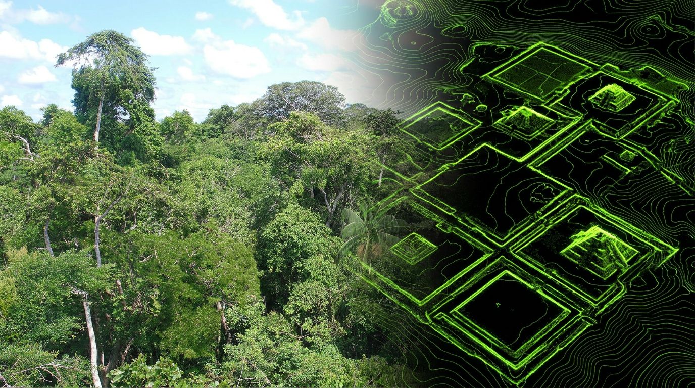
For centuries, the Amazon basin was viewed by outsiders as an impenetrable, pristine wilderness—a place where the sheer density of the jungle precluded the rise of complex, large-scale civilizations. That foundational myth is currently being dismantled by billions of laser pulses. In 2026, the convergence of spaceborne LiDAR technology and advanced machine learning models has allowed researchers to digitally strip away the canopy, revealing a vast, interconnected network of ancient urban centers. The evidence points to a highly structured, anthropogenically modified landscape that supported millions of people long before European contact, fundamentally rewriting our understanding of pre-Columbian history in South America.[1][7]
The primary claim emerging from this wave of research is that the pre-Columbian Amazon was not a sparse collection of nomadic hunter-gatherer tribes, but a continent-spanning web of "garden cities." Recent data published in leading scientific journals details settlements dating back over 2,500 years, featuring straight streets, sophisticated drainage canals, and monumental geometric earthworks. Some of these urban footprints stretch across 500 hectares, linked by raised causeways designed to keep trade routes open during seasonal floods. These were not temporary camps, but permanent, engineered metropolises that required centralized planning and a deep understanding of the local hydrology.[2][5]
The sheer scale of the findings is staggering, challenging everything previously taught in historical textbooks. Analysts at the Brazilian National Institute for Space Research, combining multiple regional datasets, estimate that between 10,000 and 24,000 pre-Columbian earthworks remain hidden across the Amazon River basin. These structures range from perfect circles and concentric squares to complex hexagons spanning hundreds of meters in diameter. Rather than isolated outposts, the spatial distribution suggests shared architectural rules, regional planning, and a deep understanding of astronomical alignments, indicating a culturally connected civilization that spanned multiple modern-day national borders.[1][3]

The engine driving this paradigm shift is Light Detection and Ranging, commonly known as LiDAR. Historically, finding ruins in the Amazon required sheer luck, localized ground surveys, or visual scouting following destructive clear-cutting of the forest. Modern LiDAR, mounted on aircraft or utilizing spaceborne instruments like NASA’s Global Ecosystem Dynamics Investigation (GEDI) on the International Space Station, fires millions of laser pulses per second at the forest. While most pulses hit the canopy, a fraction slip through the leaves and bounce off the forest floor, creating a high-resolution, three-dimensional topographical map of the ground beneath the trees.[1][3][6]
But raw LiDAR data is inherently noisy, and manually scanning millions of square kilometers for subtle ground anomalies is a nearly impossible task for human researchers. The 2026 breakthrough relies on the deployment of specialized object-detection machine learning frameworks. Systems trained on known archaeological sites use predictive gradient-boosting to search unmapped wilderness for identical geometric signatures. These AI models effectively "digitally deforest" the terrain, calculating the precise relationship between tree canopy height and true ground elevation to isolate man-made micro-reliefs that are entirely invisible to the naked eye, drastically accelerating the pace of discovery.[1][7]
But raw LiDAR data is inherently noisy, and manually scanning millions of square kilometers for subtle ground anomalies is a nearly impossible task for human researchers.
The evidence extends beyond digital maps into the soil itself, proving that these populations lived in harmony with their environment. Ecologists and geographers are finding that the ancient Amazonians engineered their habitat to sustain massive populations without destroying the forest. The presence of "Terra Preta"—rich, dark, composted earth created by human waste, charcoal, and pottery shards—corroborates the LiDAR data. These ancient societies cultivated fisheries and groomed the surrounding jungle into managed orchards, creating a sustainable model of urbanism that modern cities, currently grappling with climate change and resource depletion, are now eagerly studying.[3][5]

Despite the unprecedented clarity of the digital maps, the evidence pack contains significant gaps that require transparent acknowledgment. LiDAR is strictly a remote sensing tool; it highlights exactly where to dig, but it cannot replace the physical excavation required to truly understand a site. For the vast majority of the newly identified 10,000-plus earthworks, archaeologists possess zero physical artifacts. Without ground-truthing, researchers cannot definitively date the structures, identify the specific cultures and languages of the builders, or understand the daily lives of the inhabitants. The lasers reveal the impressive skeleton of a civilization, but the cultural flesh remains a mystery.[2][7]
Another major area of uncertainty within the archaeological community is the exact timeline and cause of the civilization's abandonment. While the prevailing theory suggests that European diseases—introduced in the 16th century—swept through these interconnected trade routes and decimated the populations long before colonial explorers ever saw the cities, the exact sequence of events is difficult to prove without extensive carbon dating. Some settlements appear to have been abandoned centuries before European contact, pointing to potential climate shifts, regional conflicts, or resource exhaustion. The digital maps show us what was built, but they are entirely silent on why it fell quiet.[2][7]
As these high-tech discoveries make global headlines, a strong counter-narrative has emerged regarding how the evidence is framed for the public. Academic reviews, such as a recent comprehensive analysis published in Advances in Archaeological Practice, heavily critique the media's tendency to label these findings as the sudden discovery of "lost cities." This framing implies that the settlements were entirely unknown until Western scientists pointed lasers at them, a narrative that critics argue is both scientifically inaccurate and culturally erasing, ignoring the complex history of the region.[4][7]

The reality is that many of these sites were never truly lost to the people who actually live there. Local Indigenous communities have lived alongside and known about these earth mounds for generations, integrating them into their own cultural geographies. Furthermore, earlier generations of archaeologists had already documented hundreds of these sites through painstaking, labor-intensive ground surveys decades before LiDAR was invented. The recent technological leaps have provided unprecedented scale and synthesis, but presenting the findings as a sudden, virgin discovery ignores the foundational knowledge of Indigenous populations and early field researchers.[4]
Moving forward, the discipline is attempting to balance the sheer power of geospatial AI with the ethical requirements of modern, inclusive archaeology. Expeditions are increasingly relying on private-industry partnerships and crowdfunding to finance the expensive ground-truthing required to verify the AI's predictions, while simultaneously ensuring that local communities are partners in the research. Organizations are now emphasizing that if parts of the forest include ancient human landscapes, protecting the Amazon is no longer just about preserving biodiversity—it is about defending the largest contiguous archaeological heritage site on Earth from modern deforestation.[2][6]
The 2026 synthesis of spaceborne data and machine learning has definitively closed the book on the myth of the Amazon as an untouched, pristine wilderness. The evidence pack—comprising billions of laser data points, AI-generated topographical maps, and rich anthropogenic soils—proves that complex, sustainable urbanism thrived in the rainforest for millennia. As researchers transition from scanning the canopy from space to digging in the dirt on the ground, the next decade of discovery will focus on listening to the stories those ancient engineers left behind, ensuring their legacy is finally recognized.[1][3][7]
How we got here
Pre-1500s
Millions of people inhabit interconnected 'garden cities' across the Amazon basin, engineering the landscape with causeways and canals.
16th Century
European contact introduces devastating diseases, leading to the rapid depopulation and abandonment of the urban networks.
1970s–2000s
Archaeologists and local communities document isolated earthworks, but the sheer scale of the civilization remains hidden by the canopy.
2024
A landmark study in Science reveals a 2,500-year-old network of cities in the Ecuadorian Amazon, sparking global interest.
2026
The deployment of spaceborne LiDAR and AI object-detection models maps up to 24,000 earthworks, fundamentally rewriting Amazonian history.
Viewpoints in depth
Geospatial Archaeologists
Advocates for the use of remote sensing and AI to map the Amazon at an unprecedented scale.
This camp views the integration of spaceborne LiDAR and machine learning as the most significant methodological leap in modern archaeology. By utilizing tools like NASA's GEDI and AI models such as GlyphTrack, they argue that we can finally grasp the true macro-scale of pre-Columbian civilization without cutting down a single tree. For these researchers, the priority is scanning as much of the basin as possible before modern deforestation destroys the remaining earthworks.
Ecologists & Anthropologists
Focuses on the sustainable 'garden urbanism' practiced by ancient Amazonians.
Rather than focusing solely on the technology, this perspective is fascinated by what the data says about human-environment interaction. They point to the widespread presence of Terra Preta and managed orchards as proof that dense urban populations do not inevitably lead to ecological collapse. This camp argues that modern city planners and agriculturalists have much to learn from how these ancient societies engineered the rainforest to be more productive while maintaining its biodiversity.
Indigenous Heritage Advocates
Critiques the 'lost city' media narrative and centers Indigenous knowledge.
This viewpoint strongly pushes back against the framing of these discoveries as sudden, virgin finds by Western scientists. They argue that the 'lost city' trope erases the fact that local Indigenous communities have lived alongside these earthworks for centuries. Furthermore, they emphasize that presenting the Amazon as an empty wilderness waiting to be 'discovered' by lasers ignores decades of painstaking, ground-level archaeological work and the ongoing cultural connection modern Indigenous peoples have to these ancestral sites.
What we don't know
- The exact identities, languages, and cultures of the people who built the majority of the newly mapped earthworks.
- The precise timeline and specific causes for the abandonment of these massive urban networks.
- What physical artifacts lie buried beneath the thousands of sites that have been scanned but not yet excavated.
Key terms
- LiDAR
- A remote sensing method that uses light in the form of a pulsed laser to measure variable distances to the Earth, creating highly accurate 3D maps.
- Geoglyph
- A large design or motif produced on the ground, typically formed by moving rocks or earth, such as the geometric trenches found in the Amazon.
- Terra Preta
- Rich, dark, human-made soil found in the Amazon basin, created by ancient populations mixing charcoal, bone, and compost to improve agricultural fertility.
- Ground-truthing
- The process of verifying data gathered by remote sensing (like LiDAR) through physical, on-site archaeological excavation.
- Garden Urbanism
- A model of city planning where dense human settlements are integrated with agricultural plots and managed forests, rather than replacing them.
Frequently asked
What is LiDAR and how does it work?
LiDAR stands for Light Detection and Ranging. It uses millions of laser pulses to measure distances, allowing researchers to digitally strip away the jungle canopy and map the ground beneath.
Did these ancient cities destroy the rainforest?
No. Evidence suggests these societies practiced 'garden urbanism,' enriching the soil with compost and managing orchards, sustaining large populations while preserving the forest ecosystem.
Why were these Amazonian cities abandoned?
While the exact cause is uncertain, the leading theory is that European diseases introduced in the 16th century decimated the populations, though some sites may have been abandoned earlier due to climate shifts.
Were these cities truly 'lost'?
Not entirely. While LiDAR revealed their massive scale, local Indigenous communities and earlier ground-level archaeologists already knew about many of these earthworks.
Sources
Source coverage
7 outlets
3 viewpoints surfaced


[1]The ArchaeologistGeospatial Archaeologists
The Revealing of a Garden City Civilization: Spaceborne LiDAR and AI
Read on The Archaeologist →[2]Colombia OneEcologists & Anthropologists
Lost Amazon Cities Found With LiDAR, Revealing a 2,500-Year-Old Network
Read on Colombia One →[3]The GuardianEcologists & Anthropologists
Lidar reveals ancient Amazonians engineered the habitat
Read on The Guardian →[4]Advances in Archaeological PracticeIndigenous Heritage Advocates
Media Framing of LiDAR Discoveries and the Erasure of Indigenous Knowledge
Read on Advances in Archaeological Practice →[5]ScienceEcologists & Anthropologists
Two millennia of garden urbanism in the Ecuadorian Amazon
Read on Science →[6]Terra Incognita Research InstituteGeospatial Archaeologists
Using NASA Datasets to Uncover Ancient Civilizations
Read on Terra Incognita Research Institute →[7]Factlen Editorial TeamIndigenous Heritage Advocates
Synthesis by Factlen editorial team
Read on Factlen Editorial Team →

Every angle. Every day.
Get science stories with full source coverage and perspective breakdowns delivered to your inbox.