How AI and Satellite Intelligence Are Illuminating the Ocean's 'Dark Fleet'
A new generation of open-source intelligence tools is combining satellite radar and machine learning to track illegal fishing vessels that attempt to operate off the grid.
By Factlen Editorial Team
- Conservation Intelligence Advocates
- Environmental NGOs and data scientists who view open-source satellite data as the ultimate equalizer in ocean governance.
- Maritime Security & Defense
- Military and coast guard officials who view illegal fishing through the lens of geopolitical stability and national security.
- Commercial Seafood Sector
- Major retailers, processors, and industry groups focused on supply chain compliance and market access.
- Privacy & Surveillance Skeptics
- Legal scholars and privacy advocates concerned about the ethical implications of ubiquitous oceanic monitoring.
What's not represented
- · Small-scale artisanal fishers who cannot afford tracking equipment
- · Crews trapped in forced labor aboard dark fleet vessels
Why this matters
Illegal fishing devastates marine ecosystems and introduces billions of dollars of illicit seafood into the global supply chain. By democratizing military-grade satellite intelligence, AI is empowering conservationists and governments to finally hold the 'dark fleet' accountable, ensuring the seafood on your plate is legally and sustainably sourced.
Key points
- Illegal fishing costs the global economy up to $23.5 billion annually and devastates marine ecosystems.
- Vessels frequently disable their public tracking transponders to operate as a 'dark fleet' off the grid.
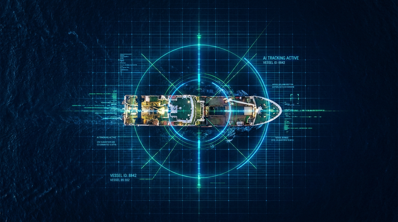
- Synthetic Aperture Radar (SAR) satellites can detect metal ships through cloud cover and darkness.
- Machine learning algorithms cross-reference radar blips with public broadcasts to instantly flag evasive vessels.
- Recent studies prove this technology is successfully deterring poaching in highly protected marine reserves.
For centuries, the sheer vastness of the global ocean provided an impenetrable shield for illicit activity. Illegal, unreported, and unregulated (IUU) fishing has long operated in these blind spots, devastating marine ecosystems and costing the global economy an estimated $10 billion to $23.5 billion annually. Up to one in five fish sold globally is caught illegally, undermining sustainable fisheries and the coastal communities that rely on them. But a quiet revolution in open-source intelligence (OSINT) and artificial intelligence is rapidly illuminating the high seas, stripping away the anonymity that environmental criminals have historically relied upon.[4][7]
Historically, maritime domain awareness depended heavily on the Automatic Identification System (AIS), a radio frequency transceiver system designed to prevent vessel collisions. While AIS provides a wealth of data, it has a fatal flaw for law enforcement: it relies on the cooperation of the vessel's captain. Bad actors routinely disable their AIS transponders, tamper with the data, or spoof their locations to create 'ghost ships' that vanish from public surveillance systems.[1][4]
This evasion tactic gave rise to the 'dark fleet'—vessels operating completely off the grid. Recent studies have revealed the staggering scale of this unseen armada. According to research published in the journal Science, when researchers compared traditional AIS tracking with advanced satellite imagery, they discovered that in some coastal regions, roughly 75% of industrial fishing vessels were not broadcasting their positions. Monitoring the oceans required a technological leap beyond cooperative radio signals.[1][2]

That leap arrived through the democratization of space-based sensors, specifically Synthetic Aperture Radar (SAR). Unlike traditional optical satellites, which are blinded by cloud cover and darkness, SAR beams microwave pulses down to the ocean surface and measures the reflection. Because metal ships are highly reflective, they appear as bright, undeniable blips on the radar, regardless of the weather or the time of day.[1][5]
Alongside SAR, intelligence analysts are deploying the Visible Infrared Imaging Radiometer Suite (VIIRS), a highly sensitive optical sensor capable of detecting the powerful halogen lights used by squid jiggers and other nocturnal fishing fleets. By layering these distinct data streams—AIS, SAR, and VIIRS—researchers can create a comprehensive map of the ocean. However, the sheer volume of this data, amounting to petabytes of imagery, is impossible for human analysts to review manually.[2]
This is where artificial intelligence transforms raw data into actionable intelligence. Organizations like Global Fishing Watch and OceanMind have trained deep learning models to process millions of gigabytes of satellite imagery. The AI acts as a massive sorting mechanism, automatically detecting vessels in SAR and optical imagery and cross-referencing those coordinates against public AIS broadcasts.[2][3][6]
This is where artificial intelligence transforms raw data into actionable intelligence.
When the AI finds a radar blip that lacks a corresponding AIS signal, it instantly flags the vessel as 'dark.' Furthermore, machine learning algorithms analyze the movement patterns of these vessels. A ship steaming in a straight line is likely in transit, but a vessel moving in tight, erratic zig-zags at low speeds is exhibiting the classic behavioral signature of active fishing.[2][6]
The evidence supporting the efficacy of these AI models is robust. A comprehensive analysis of nearly 1,400 marine protected areas (MPAs) spanning 3 million square miles utilized these exact OSINT techniques. The study proved that in MPAs where industrial fishing is strictly banned, the combination of AI and satellite radar has successfully deterred poaching. In Costa Rica's Cocos Island National Park and the Galapagos Islands, evidence of illegal fishing dropped substantially after authorities integrated radar-based vessel tracking into their enforcement protocols.[1]

Beyond identifying active fishing, AI behavioral models are exposing the complex logistics networks that support the dark fleet. Maritime intelligence firms utilize AI to detect suspicious ship-to-ship transfers, known as transshipment. By analyzing vessel classes, loitering times, and rendezvous locations far from shore, the AI can identify where illegally caught fish are laundered into the holds of massive refrigerated cargo ships, obscuring their illicit origins before they reach port.[4]
The geopolitical and security implications of this technology are profound. The U.S. Coast Guard and the Defense Innovation Unit have recognized IUU fishing not just as an environmental issue, but as a leading global maritime security threat. The ability of automated algorithms to rapidly characterize vessels allows under-resourced coast guards and navies to deploy physical patrols only where they are needed most, transforming a game of oceanic whack-a-mole into precision enforcement.[4][5]
This intelligence is also reshaping the commercial seafood supply chain. Tech-enabled nonprofits are partnering with the Global Dialogue on Seafood Traceability (GDST) to provide third-party verification for seafood buyers. By integrating satellite data and AI, these platforms can verify the legal origin of marine ingredients, ensuring that major retailers are not inadvertently funding environmental crimes.[3]

Despite these breakthroughs, the evidence pack reveals transparent limitations to the current technology. The primary blind spot remains vessel size. While SAR satellites with 10-to-20-meter resolution can easily spot large industrial trawlers, they struggle to reliably detect artisanal boats and small-scale vessels under 15 meters in length. Because small vessels account for a significant majority of global fishing activity, a substantial portion of the ocean's extraction remains unquantified.[2]
Additionally, AI models are not infallible. Object detection algorithms can occasionally misclassify offshore infrastructure, such as oil rigs or wind turbines, as stationary vessels, requiring human analysts to verify the alerts. There are also emerging concerns regarding data privacy and the ethics of mass surveillance, as the same tools used to track illegal fishing could theoretically be repurposed by state actors for broader maritime monitoring.[2][7]

Nevertheless, the trajectory of open-source maritime intelligence points toward an increasingly transparent ocean. As satellite constellations expand to provide more frequent revisit times and higher-resolution imagery, the temporal and spatial gaps where the dark fleet can hide are rapidly shrinking. By placing military-grade intelligence capabilities into the hands of conservationists, journalists, and the public, AI is fundamentally shifting the balance of power at sea.[5][6][7]
How we got here
2014
Global Fishing Watch is founded as a partnership between Oceana, SkyTruth, and Google to map global fishing activity using AIS data.
2018
OceanMind officially launches as an independent nonprofit, utilizing machine learning to provide enforcement support to marine protected areas.
2022
Researchers begin applying deep learning to petabytes of satellite radar (SAR) imagery, revealing the true scale of the non-broadcasting 'dark fleet'.
2025
A landmark study in the journal Science proves that AI and satellite radar are successfully deterring illegal fishing in heavily protected marine reserves.
2026
High-resolution commercial satellite imagery becomes increasingly integrated into OSINT platforms, shrinking the blind spots for smaller vessels.
Viewpoints in depth
Conservation Intelligence Advocates
Environmental NGOs and data scientists who view open-source satellite data as the ultimate equalizer in ocean governance.
This camp argues that the historical reliance on state-run navies and physical patrols was fundamentally unscalable. By democratizing access to petabytes of satellite imagery and AI models, organizations like Global Fishing Watch believe they are stripping away the impunity of the high seas. They emphasize that radical transparency—making vessel tracks publicly accessible to anyone with an internet connection—is the only way to hold both illicit operators and negligent flag states accountable.
Maritime Security & Defense
Military and coast guard officials who view illegal fishing through the lens of geopolitical stability and national security.
For defense analysts, the 'dark fleet' is not just an environmental hazard; it is a vector for transnational organized crime, human trafficking, and state-sponsored territorial encroachment. Agencies like the U.S. Coast Guard and the Defense Innovation Unit value AI-driven SAR data because it acts as a force multiplier. Instead of blindly patrolling vast exclusive economic zones (EEZs), military assets can be deployed with precision to intercept high-probability targets, conserving resources while projecting authority.
Commercial Seafood Sector
Major retailers, processors, and industry groups focused on supply chain compliance and market access.
The legitimate fishing industry increasingly relies on AI verification to protect its brand reputation and comply with tightening import regulations. Groups aligned with the Global Dialogue on Seafood Traceability (GDST) utilize platforms like OceanMind to audit their supply chains. For this camp, satellite intelligence is a risk-management tool that proves their catch is legal, allowing them to maintain access to premium markets in the US and EU while isolating bad actors who undercut prices through illegal extraction.
Privacy & Surveillance Skeptics
Legal scholars and privacy advocates concerned about the ethical implications of ubiquitous oceanic monitoring.
While generally supportive of stopping environmental crime, this viewpoint raises alarms about the normalization of mass surveillance. Skeptics point out that the same AI models used to track fishing vessels can be dual-purposed by authoritarian regimes to monitor dissidents fleeing by sea or to track rival commercial shipping. Furthermore, they highlight the 'black box' nature of AI algorithms, warning that false positives could lead to unwarranted boardings or the unjust blacklisting of small-scale artisanal fishers who simply cannot afford advanced AIS transponders.
What we don't know
- Exactly how much illegal fishing is conducted by small, artisanal vessels under 15 meters, which remain largely invisible to current radar satellites.
- How illicit fleets will adapt their evasion tactics as AI detection becomes ubiquitous, such as deploying radar-absorbing materials or advanced spoofing.
- Whether international legal frameworks will evolve quickly enough to allow AI-generated satellite evidence to be used as the sole basis for criminal prosecution.
Key terms
- Open-Source Intelligence (OSINT)
- Intelligence gathered from publicly available sources, such as commercial satellite imagery and public radio broadcasts, rather than classified espionage.
- Automatic Identification System (AIS)
- A radio tracking system used by ships to broadcast their location, speed, and identity to prevent collisions at sea.
- Synthetic Aperture Radar (SAR)
- A form of radar used by satellites to create two-dimensional images of landscapes and oceans, capable of penetrating clouds and operating at night.
- Transshipment
- The practice of transferring cargo, such as illegally caught fish, from one vessel to another while at sea, often used to launder the catch before it reaches port.
- Exclusive Economic Zone (EEZ)
- An area of the ocean extending 200 nautical miles from a country's coast, over which that country has special rights regarding the exploration and use of marine resources.
Frequently asked
What is the 'dark fleet'?
The dark fleet refers to commercial vessels that deliberately turn off their tracking transponders or spoof their locations to operate undetected, often to engage in illegal fishing or smuggling.
How does radar see through clouds?
Synthetic Aperture Radar (SAR) satellites emit microwave pulses that pass through cloud cover and darkness. The radar measures the energy that bounces back, easily detecting highly reflective metal ships.
Can AI completely stop illegal fishing?
While AI cannot physically stop a vessel, it provides undeniable evidence of illicit activity, allowing coast guards to deploy physical patrols with precision and enabling retailers to block illegal fish from their supply chains.
Are small fishing boats tracked by this technology?
Currently, most commercial satellite radar struggles to reliably detect small artisanal boats under 15 meters in length, leaving a blind spot for small-scale coastal fishing.
Sources
Source coverage
7 outlets
4 viewpoints surfaced


[1]ScienceConservation Intelligence Advocates
Using AI and Satellites to Track Illegal Fishing in Marine Protected Areas
Read on Science →[2]Global Fishing WatchConservation Intelligence Advocates
Mapping the Dark Fleet with Satellite Radar and Machine Learning
Read on Global Fishing Watch →[3]OceanMindCommercial Seafood Sector
Leading the charge against IUU fishing through satellite technology and AI
Read on OceanMind →[4]WindwardMaritime Security & Defense
Illuminating IUU Fishing: AI-driven data and behavioral insights
Read on Windward →[5]Defense OneMaritime Security & Defense
Technology Helps Satellites Track IUU Fishing Boats Despite Obstacles
Read on Defense One →[6]BBC NewsConservation Intelligence Advocates
How AI is being used to prevent illegal fishing
Read on BBC News →[7]Factlen Editorial TeamPrivacy & Surveillance Skeptics
Synthesis by Factlen editorial team
Read on Factlen Editorial Team →
Every angle. Every day.
Get defense security stories with full source coverage and perspective breakdowns delivered to your inbox.