How North America is Rebuilding Its Fragmented Wildlife Corridors
A surge in wildlife crossings and transboundary conservation efforts is successfully reconnecting isolated animal populations across the U.S. and Canada.
By Factlen Editorial Team
- Conservation Organizations
- Focused on preserving genetic diversity, reconnecting fragmented habitats, and enabling climate-driven migration.
- Academic Researchers
- Focused on utilizing spatial data and circuit theory modeling to map the most critical connectivity corridors.
- Transportation & Safety Authorities
- Focused on driver safety, reducing the $8 billion economic toll of collisions, and building resilient infrastructure.
What's not represented
- · Automobile insurance companies who bear the financial cost of wildlife collisions
- · Local municipalities managing the zoning of land adjacent to highway crossings
Why this matters
With over a million large animals killed on U.S. roads annually—costing $8 billion and hundreds of human lives—wildlife crossings offer a rare, permanent solution that saves taxpayer money while rescuing isolated species from localized extinction.
Key points
- Wildlife-vehicle collisions kill up to two million large animals annually in the U.S. and cost $8 billion.
- Wildlife crossings, paired with miles of funnel fencing, can reduce motorist collisions by up to 80 percent.
- The Yellowstone to Yukon initiative has successfully installed 204 crossings, shrinking the gap between isolated grizzly populations.
- A 2026 binational study mapped ecological connectivity across the entire U.S.-Canada border to guide future infrastructure.
- Only 20 percent of high-value transboundary corridors are currently protected, highlighting the need for private land conservation.
Interstate 90 is the longest highway in the United States, spanning more than 3,000 miles from Seattle to Boston. But for the wildlife living in the Snoqualmie Pass of Washington State, the highway is a massive, lethal concrete divide. Every 26 seconds, a driver in the U.S. hits an animal. These collisions kill up to two million large animals annually, cause hundreds of human fatalities, and generate more than $8 billion in economic damages. For decades, the solution was simply to put up warning signs. Today, North America is embracing a permanent, structural fix: wildlife crossings.[4]
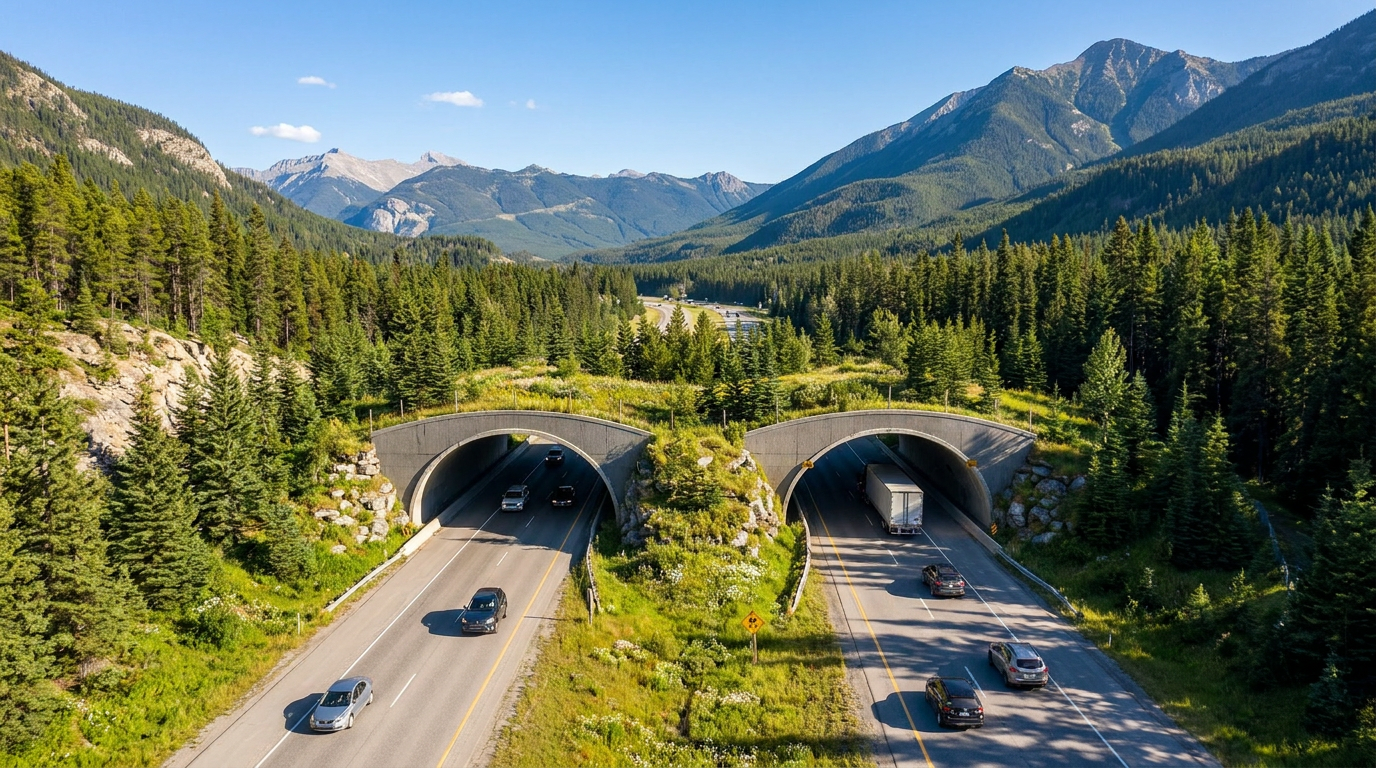
Wildlife crossings are specialized infrastructure—ranging from vegetated overpass bridges to subterranean culverts—designed to stitch fragmented ecosystems back together. They are not merely a safety measure for motorists; they are a biological necessity. When highways bisect a forest, animal populations become isolated. "Because you lose genetic variability," explains Patty Garvey-Darda, a U.S. Forest Service biologist, "gradually you start getting localized extinction, and populations get further and further apart, and smaller."[4][6]
The mechanism behind a successful crossing relies on behavioral psychology as much as structural engineering. Animals do not naturally seek out concrete bridges. To make the crossings effective, engineers install miles of high fencing along the highway to funnel wildlife toward the safe passage. Once there, the structures are landscaped with native plants, soil, and rocks to mimic the surrounding environment. High concrete walls block the glare of headlights and muffle the roar of semi-trucks, allowing animals to cross without realizing they are traversing a major interstate.[4][6]
The undisputed gold standard for this infrastructure is Banff National Park in Alberta, Canada. Decades ago, the Trans-Canada Highway was a death trap for local fauna. Today, a network of 38 underpasses and six overpasses spans the highway. The results have been staggering: wildlife-vehicle collisions in the park have plummeted by 80 percent. The Banff model proved that if you build it—and fence it correctly—they will indeed come.[4][6]

Inspired by Banff, the concept has scaled into one of the most ambitious conservation projects in human history: the Yellowstone to Yukon (Y2Y) Conservation Initiative. Stretching 2,000 miles from Wyoming to the Canadian Arctic, the Y2Y corridor aims to create a continuous "wildway" along the spine of the Rocky Mountains. By the start of 2026, the initiative and its partners had successfully installed 204 wildlife crossings across the region, effectively reconnecting landscapes that had been severed for a century.[1][6]
Inspired by Banff, the concept has scaled into one of the most ambitious conservation projects in human history: the Yellowstone to Yukon (Y2Y) Conservation Initiative.
The ecological dividends of the Y2Y mega-corridor are already measurable. In 1993, grizzly bear populations in the lower 48 states were separated by 150 miles of hostile, human-dominated terrain—a gap that threatened their genetic viability. By 2025, strategic land purchases and new highway crossings had shrunk that gap to just 45 miles. In southeast British Columbia alone, conservationists recently secured 112,000 acres of land to ensure the corridor remains unbroken.[1][6]
The push for connectivity is not limited to the lush forests of the Pacific Northwest or the Canadian Rockies. In the arid expanses of Nevada and Arizona, Highway 93 serves as a primary trade route connecting Canada, the U.S., and Mexico. It also cuts directly through the historic migration routes of the desert bighorn sheep and mule deer. A network of overpasses completed over the last decade has recorded tens of thousands of successful animal crossings, reducing motorist crashes by nearly 90 percent in targeted zones.[5][6]

Designing these corridors requires immense precision. Conservationists look for "pinch points"—natural bottlenecks where topography forces wildlife into a narrow geographic band. They also analyze traffic volume. Roads carrying fewer than 2,500 vehicles a day pose a low barrier, but highways with over 10,000 vehicles daily act as a total wall, where animals simply give up trying to cross. Identifying where a pinch point meets a high-volume road dictates exactly where a multi-million-dollar overpass must be built.[3][6]
As the climate warms, the need for these corridors is becoming urgent. Species are being forced to migrate northward or to higher elevations to track shifting temperature bands. If their escape routes are blocked by impassable highways, entire populations could collapse. Recognizing this, a landmark 2026 study published in the journal FACETS mapped ecological connectivity across the entire U.S.-Canada border—the longest terrestrial boundary in the world.[2][6]
The researchers utilized "circuit theory modeling," a spatial ecology technique that treats the landscape like an electrical grid. Human development and highways act as "resistance," while natural forests and rivers act as conductive pathways. The resulting high-resolution map identified the exact transboundary corridors where wildlife movement is concentrated, providing a blueprint for where the U.S. and Canada must coordinate their next wave of infrastructure investments to meet global biodiversity targets.[2][6]

Despite the proven success of wildlife crossings, significant hurdles remain. The 2026 mapping study revealed that only about 20 percent of the highest-value connectivity hotspots along the border fall within strictly protected areas. The rest lie on private land, agricultural zones, or indigenous territories. Expanding the corridor network will require voluntary conservation easements from ranchers and deep collaboration with Indigenous nations, who are increasingly co-managing these vital landscapes.[2][6]
Ultimately, the proliferation of wildlife crossings represents a profound shift in how North America manages its infrastructure. Highways are no longer viewed merely as arteries for human commerce, but as obstacles that must be bridged for the continent's original inhabitants. By investing in concrete, fencing, and native vegetation, engineers and ecologists are slowly stitching a fragmented continent back together, ensuring that the ancient migrations of elk, bears, and panthers can continue into the next century.[6]
How we got here
1993
The Yellowstone to Yukon (Y2Y) Conservation Initiative is founded to connect 2,000 miles of habitat.
2016
Arizona completes the Sonoran Desert's first wildlife overpass on State Route 77, reconnecting vulnerable mountain linkages.
2025
Y2Y reports the gap between isolated grizzly bear populations has shrunk to just 45 miles, down from 150 miles in 1993.
Early 2026
A landmark binational study maps ecological connectivity across the entire U.S.-Canada border to guide future crossings.
Viewpoints in depth
Conservation Biologists
Focused on preserving genetic diversity and enabling climate-driven migration.
For ecologists and biologists, wildlife crossings are primarily a tool to combat habitat fragmentation, which they view as the leading cause of localized extinctions. They argue that isolated populations suffer from inbreeding and are highly vulnerable to disease or environmental shocks. Furthermore, as climate change shifts temperature bands, biologists emphasize that species must be able to migrate northward or to higher elevations. Without connected corridors, these climate-driven migrations will be blocked by human infrastructure, leading to catastrophic biodiversity loss.
Transportation Planners
Focused on driver safety and the economic toll of vehicle collisions.
Highway authorities and civil engineers approach the issue through the lens of public safety and economics. With 1 to 2 million large animals killed on U.S. roads annually, collisions result in hundreds of human fatalities and over $8 billion in property damage, medical costs, and emergency response expenses. For this camp, the multi-million-dollar price tag of a wildlife overpass is easily justified by the long-term savings. They rely heavily on traffic volume data and crash-hotspot mapping to prioritize construction where it will save the most human lives and taxpayer dollars.
Private Landowners & Ranchers
Focused on balancing conservation with agricultural viability and property rights.
Because a significant portion of critical wildlife corridors falls outside of protected national parks, the success of these initiatives often hinges on private landowners. Ranchers and farmers generally support reducing highway collisions, but they are cautious about top-down federal mandates that might restrict land use. This camp advocates for voluntary conservation easements, where landowners are financially compensated for maintaining natural habitats and allowing wildlife to pass through their property without threatening livestock or agricultural operations.
What we don't know
- How future federal infrastructure budgets will prioritize wildlife crossings compared to traditional road expansions.
- Whether private landowners will voluntarily adopt conservation easements at the scale required to protect the remaining 80 percent of transboundary corridors.
Key terms
- Wildlife Corridor
- A strip of natural habitat connecting populations of wildlife that are otherwise separated by human activities or structures.
- Genetic Diversity
- The total variety of genetic characteristics within a species, which is crucial for preventing inbreeding and localized extinction.
- Circuit Theory Modeling
- A spatial ecology method used to predict animal movement by treating landscapes like electrical grids, where human development acts as resistance.
- Pinch Point
- A natural geographic bottleneck where topography or human development forces migrating wildlife into a narrow corridor.
Frequently asked
Do animals actually know to use the bridges?
Animals do not naturally seek out concrete bridges. Engineers install miles of high fencing along the highway to funnel wildlife toward the safe passage, which is landscaped with native plants to mimic the surrounding environment.
Are wildlife crossings only for large mammals?
No. While large overpasses often serve elk and bears, smaller underpasses and culverts are specifically designed for amphibians, reptiles, and smaller mammals.
How much do these crossings cost?
While initial construction is expensive, studies show they pay for themselves over the long term by drastically reducing the $8 billion annual cost of vehicle damage, medical bills, and lost wildlife.
What is the Yellowstone to Yukon initiative?
It is a massive conservation project aiming to create a continuous 2,000-mile 'wildway' along the Rocky Mountains, utilizing land protections and wildlife crossings to connect habitats from Wyoming to the Canadian Arctic.
Sources
Source coverage
6 outlets
3 viewpoints surfaced


[1]Yellowstone to Yukon Conservation InitiativeConservation Organizations
2025 Impact Report: Reconnecting Fragmented Landscapes
Read on Yellowstone to Yukon Conservation Initiative →[2]FACETSAcademic Researchers
Evaluating transboundary connectivity to support cross-border conservation between Canada and the United States
Read on FACETS →[3]Wildlands NetworkConservation Organizations
US 395 Road Ecology Study and Wildlife Crossing Prioritization
Read on Wildlands Network →[4]CBS NewsTransportation & Safety Authorities
How wildlife crossings are saving animals and drivers
Read on CBS News →[5]Center for Large Landscape ConservationTransportation & Safety Authorities
Wildlife Crossing Success Stories in the Western States
Read on Center for Large Landscape Conservation →[6]Factlen Editorial TeamAcademic Researchers
Synthesis by Factlen editorial team
Read on Factlen Editorial Team →
Every angle. Every day.
Get world stories with full source coverage and perspective breakdowns delivered to your inbox.