How AI and Drones Are Rewriting the Rules of Humanitarian Demining
Advanced machine learning and drone-mounted sensors are accelerating the clearance of unexploded ordnance, offering a safer and faster path to reclaiming hazardous land.
By Factlen Editorial Team
- Humanitarian Demining NGOs
- Prioritize practical, field-ready tools that immediately improve safety and speed.
- Robotics & AI Researchers
- Focus on pushing the boundaries of sensor fusion to achieve fully autonomous subsurface detection.
- Policy & Funding Advocates
- Highlight the economic democratization of clearance technology to secure broader international funding.
What's not represented
- · Local communities living in contaminated areas whose agricultural practices are disrupted by clearance delays.
- · Manufacturers of traditional manual demining equipment facing a shifting procurement landscape.
Why this matters
By accelerating the clearance of explosive hazards, this technology directly saves civilian lives and returns millions of acres of unusable land to agricultural production. It represents a rare instance where advanced military-adjacent technology is being democratized to solve a decades-old humanitarian crisis cheaply and safely.
Key points
- Commercial drones equipped with LiDAR and RGB cameras map hazardous areas up to ten times faster than manual ground teams.
- Machine learning algorithms can identify surface-level unexploded ordnance with over 90 percent accuracy in low-vegetation environments.
- Drone-towed Ground Penetrating Radar is successfully detecting buried anti-tank mines without risking accidental detonation.
- Detecting low-metal, plastic anti-personnel mines remains a significant challenge due to environmental noise and false positives.
- The democratization of sub-$5,000 drone hardware allows local, community-led NGOs to scale their clearance operations safely.
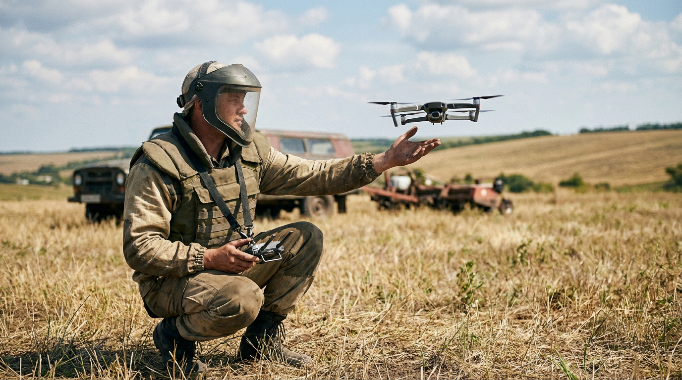
For decades, the process of clearing landmines and unexploded ordnance has been a grueling, millimeter-by-millimeter endeavor. Human deminers, clad in heavy protective gear, slowly sweep suspected fields with metal detectors and manual prodders, risking their lives with every step. It is a vital but agonizingly slow process that leaves millions of acres of agricultural land unusable and traps communities in poverty long after conflicts end. Today, an estimated 60 million people worldwide still live with the daily threat of hidden explosives, a legacy of both historical wars and modern conflicts.[1][2]
The traditional arithmetic of mine clearance is daunting. A trained human deminer might clear only a few square meters of contaminated land per day, depending on the terrain and the density of the threat. At this pace, experts have long warned that clearing the world's existing minefields could take centuries. The sheer scale of the problem has historically outpaced the funding and manpower available to humanitarian organizations, creating a desperate need for a technological force multiplier that can accelerate the pace of clearance without compromising safety.[2][5]
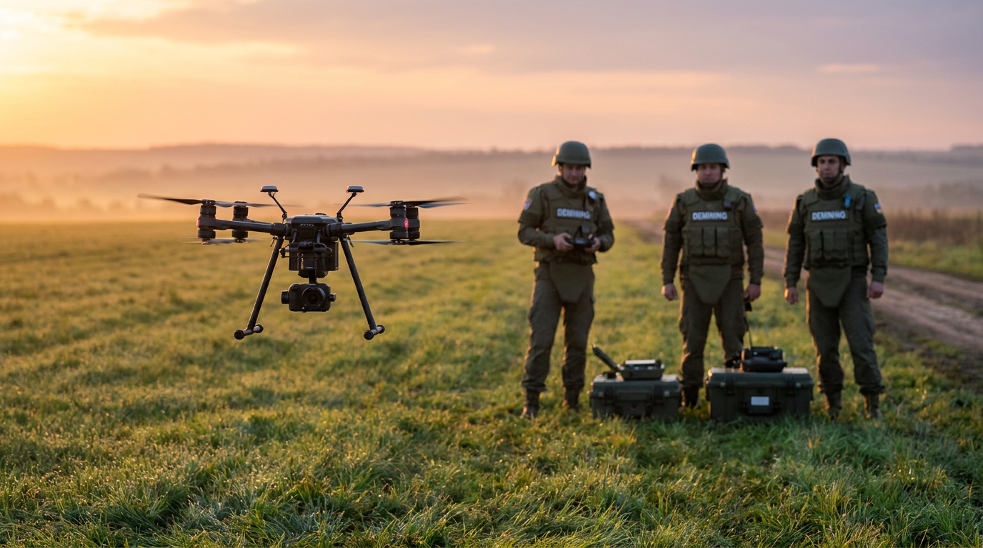
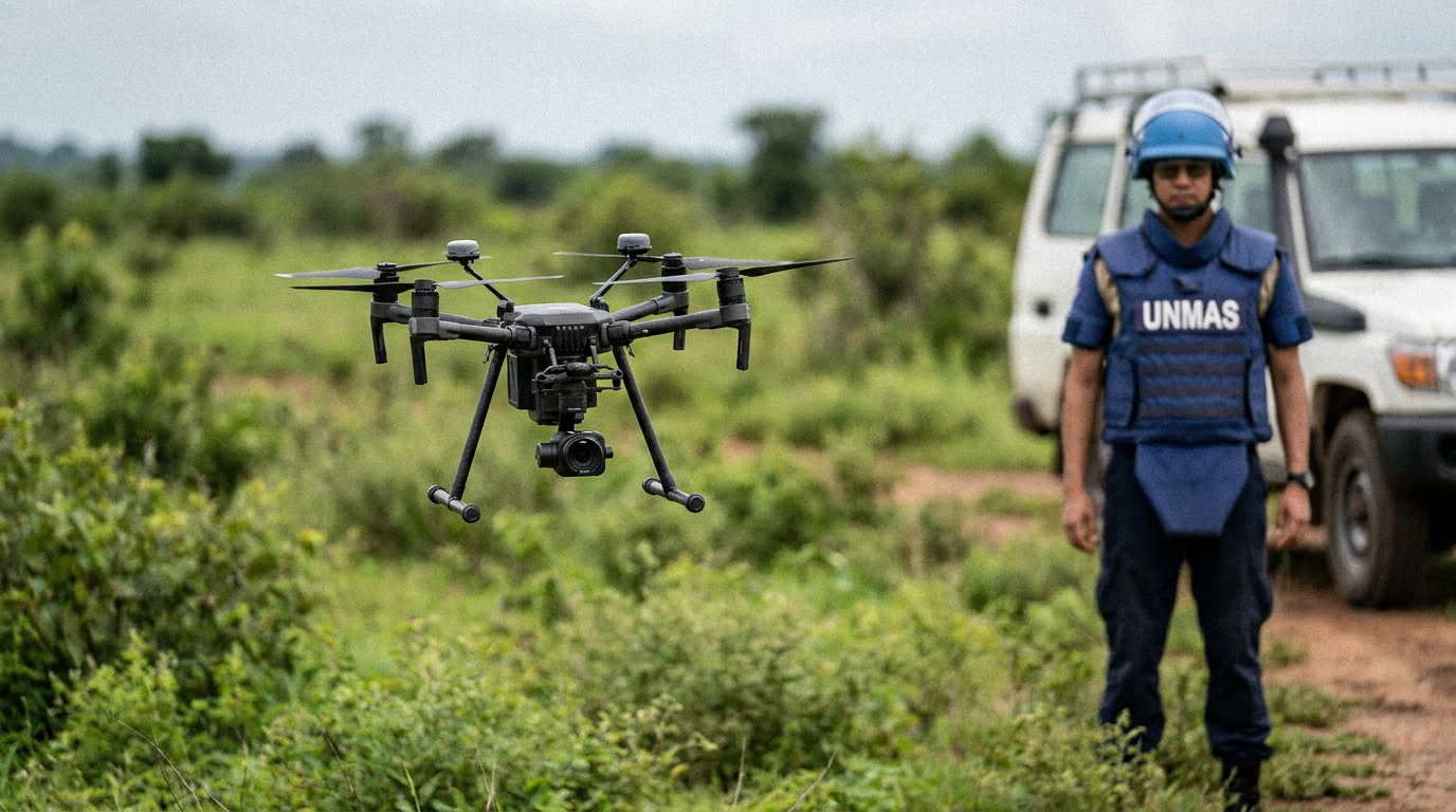
However, a quiet revolution is taking place in humanitarian mine action. By pairing commercial off-the-shelf drones with advanced machine learning algorithms, researchers and clearance organizations are fundamentally rewriting the rules of engagement. This paradigm shift is moving the most dangerous early phases of detection from the ground to the sky, allowing operators to assess hazardous environments from a safe standoff distance. The integration of these technologies is not just a theoretical exercise; it is actively reshaping how non-governmental organizations plan and execute their clearance operations globally.[1][5]
The most immediate and well-documented breakthrough is in the realm of Non-Technical Surveying. This is the critical initial phase where organizations determine the broad boundaries of a hazardous area before committing clearance teams. Historically, mapping a Suspected Hazardous Area required teams to carefully walk the perimeter or rely on outdated satellite imagery, a process fraught with risk and logistical bottlenecks. Drones equipped with high-resolution RGB cameras and LiDAR sensors are now capable of mapping these zones from above with unprecedented precision.[1][2]

The evidence supporting aerial surveying is robust. The Geneva International Centre for Humanitarian Demining and organizations like The HALO Trust report that drone photogrammetry can map Suspected Hazardous Areas up to ten times faster than human teams on the ground. By generating highly accurate three-dimensional topographical models, organizations can quickly identify blast craters, trench lines, and other indicators of conflict. More importantly, this rapid mapping allows organizations to quickly rule out safe land, returning it to local communities without wasting precious manual clearance resources on empty fields.[1][2]
Beyond simple mapping, the integration of artificial intelligence is turning drones into active detection platforms. Machine learning models, trained on thousands of images of various munitions, are now capable of automatically scanning aerial footage to flag anomalies. Instead of a human analyst spending hours squinting at video feeds, computer vision algorithms can process the data in a fraction of the time, identifying the distinct geometric shapes and metallic glints of unexploded ordnance that might be invisible to the naked eye.[4][5]
Beyond simple mapping, the integration of artificial intelligence is turning drones into active detection platforms.
Research published in the Journal of Conventional Weapons Destruction demonstrates the high efficacy of this approach. Studies show that AI can achieve over 90 percent accuracy in identifying surface-laid scatterable mines and unexploded artillery shells. In arid environments, post-conflict urban rubble, or areas with low vegetation, these algorithms can process hours of flight footage in minutes. The software then places precise GPS bounding boxes around suspected threats, generating a digital map for human teams to later investigate and neutralize.[4]
Despite these impressive surface-level capabilities, the evidence shows clear limitations when environmental conditions degrade. The efficacy of optical AI detection drops significantly in areas with dense jungle canopy, tall grass, or heavy seasonal flooding. A drone camera simply cannot see what is obscured by a foot of underbrush or a layer of mud. Consequently, while AI imagery analysis is a powerful tool, researchers caution that it cannot serve as a standalone solution in tropical or heavily forested regions, requiring complementary technologies to maintain reliable detection rates.[1][4]

The ultimate challenge—often described as the holy grail of mine action—is the reliable aerial detection of buried explosives. To address this, engineering teams are increasingly experimenting with drone-towed Ground Penetrating Radar and miniaturized magnetometer arrays. By suspending these sensors beneath heavy-lift drones flying just meters above the ground, operators can scan the subsurface without applying any physical weight to the soil, entirely eliminating the risk of accidental detonation during the scanning process.[3][5]
Studies in IEEE robotics journals highlight successful field trials of these aerial subsurface systems. The data indicates that drone-mounted Ground Penetrating Radar is highly effective at detecting larger metallic objects, such as buried anti-tank mines or deep-buried unexploded aircraft bombs. The radar pulses penetrate the earth and bounce back, creating a cross-sectional image of the subsurface that machine learning algorithms can then analyze for the distinct signatures of explosive devices.[3]
Yet, the evidence regarding aerial radar remains mixed when it comes to the most insidious threats: low-metal anti-personnel mines. These small, plastic devices are notoriously difficult to distinguish from rocks, tree roots, or soil anomalies. Furthermore, Ground Penetrating Radar generates massive volumes of complex data, and variations in soil moisture or iron content can trigger cascades of false positives. The software required to reliably filter out this environmental noise and isolate the faint signature of a plastic mine is still in its infancy, requiring significant human oversight.[3][5]

Even with these subsurface challenges, the economic impact of drone integration is undeniable. In the past, remote clearance relied on bespoke, heavily armored military vehicles that cost millions of dollars and were difficult to transport to remote villages. Today, the barrier to entry has plummeted. Sub-$5,000 commercial drones, retrofitted with specialized sensor payloads, allow local NGOs and community-led demining teams to scale their operations safely. This democratization of technology means that advanced clearance tools are no longer restricted to well-funded state militaries.[2][5]
Ultimately, the consensus among experts is that technology will not replace the human deminer, but rather optimize their deployment. By using AI and drones to rapidly eliminate empty land and pinpoint high-probability threat zones, human teams are only sent into harm's way when absolutely necessary. This targeted approach drastically reduces the time deminers spend in active minefields, lowering casualty rates and improving the overall psychological well-being of the clearance teams.[1][2][5]
Looking ahead, the next frontier involves swarm robotics—multiple drones flying in coordinated grids to fuse optical, thermal, and radar data in real-time. As these multi-sensor systems mature and AI models become more adept at filtering out false positives, they offer a profound source of hope. The synthesis of these technologies represents a realistic acceleration of a process that could finally clear the world's remaining minefields, returning millions of acres of land to the people who need it most.[3][4][5]
How we got here
Pre-2010s
Demining relies almost entirely on manual prodding, metal detectors, and animal detection.
Mid-2010s
NGOs begin using commercial drones for basic aerial photography to map post-conflict landscapes.
2020
Machine learning models are introduced to automatically scan drone imagery for surface-level unexploded ordnance.
2023-2024
Experimental drone-mounted Ground Penetrating Radar systems begin field trials for subsurface detection.
2026
AI-assisted drone surveying becomes a standard protocol for Non-Technical Surveys in major humanitarian clearance operations.
Viewpoints in depth
Humanitarian Demining NGOs
Prioritize practical, field-ready tools that immediately improve safety and speed.
Organizations like The HALO Trust emphasize that technology must serve the human operators on the ground. They argue that the greatest immediate value of drones is in Non-Technical Surveying—rapidly ruling out uncontaminated land so that manual clearance teams don't waste months probing empty fields. For these groups, a 90 percent accurate AI model is a massive win because it acts as a triage tool, even if human verification is ultimately required for final clearance.
Robotics & AI Researchers
Focus on pushing the boundaries of sensor fusion to achieve fully autonomous subsurface detection.
Academic researchers and engineers view the current optical AI capabilities as just the first step. Their primary focus is solving the 'holy grail' of detecting buried, low-metal anti-personnel mines. They argue that the future lies in multi-modal sensor fusion—combining Ground Penetrating Radar, magnetometers, and thermal imaging—processed by advanced neural networks to filter out the massive environmental noise that currently plagues subsurface scanning.
Policy & Funding Advocates
Highlight the economic democratization of clearance technology to secure broader international funding.
Policy advocates argue that the dramatic drop in hardware costs—from multi-million dollar armored vehicles to sub-$5,000 commercial drones—changes the economic calculus of global demining. They use this cost-efficiency to lobby international donors, arguing that funding should pivot toward equipping local, community-led organizations with these scalable tech stacks rather than relying solely on massive, centralized military operations.
What we don't know
- Whether software algorithms will ever become reliable enough to completely filter out the false positives generated by plastic mines in mineral-rich soils.
- How quickly international regulatory bodies will standardize the certification process for land cleared primarily by autonomous aerial systems.
- The long-term durability of commercial drone hardware when subjected to the extreme heat and dust of continuous field operations in arid climates.
Key terms
- Non-Technical Survey (NTS)
- The process of collecting and analyzing data about the presence of explosive hazards without physically entering the hazardous area.
- Unexploded Ordnance (UXO)
- Explosive weapons like bombs, shells, or grenades that did not explode when they were employed and still pose a lethal risk.
- Ground Penetrating Radar (GPR)
- A geophysical method that uses radar pulses to image the subsurface, helping detect buried objects.
- Suspected Hazardous Area (SHA)
- An area where there is reasonable suspicion of explosive hazard contamination based on indirect evidence or historical conflict data.
Frequently asked
Can drones physically remove or detonate landmines?
Currently, drones are primarily used for detection and mapping. Physical clearance or controlled detonation is still predominantly handled by trained human deminers or specialized armored ground vehicles.
How does AI identify a landmine from the air?
Machine learning algorithms are trained on vast datasets of ordnance imagery. They scan drone footage for specific shapes, thermal signatures, and metallic anomalies that match known explosive devices.
Do these systems work on buried plastic mines?
Detecting buried, low-metal anti-personnel mines remains the hardest challenge. While Ground Penetrating Radar shows promise, plastic mines are difficult to distinguish from rocks or roots using current aerial sensors.
Sources
Source coverage
5 outlets
3 viewpoints surfaced


[1]Geneva International Centre for Humanitarian DeminingHumanitarian Demining NGOs
Remote Sensing and UAVs in Mine Action
Read on Geneva International Centre for Humanitarian Demining →[2]The HALO TrustHumanitarian Demining NGOs
Innovation in Mine Action: Using Drones to Map Hazards
Read on The HALO Trust →[3]IEEE Robotics and Automation LettersRobotics & AI Researchers
UAV-Borne Ground Penetrating Radar for Landmine Detection
Read on IEEE Robotics and Automation Letters →[4]Journal of Conventional Weapons DestructionRobotics & AI Researchers
Machine Learning Applications for Unexploded Ordnance Detection
Read on Journal of Conventional Weapons Destruction →[5]Factlen Editorial TeamPolicy & Funding Advocates
Synthesis by Factlen editorial team
Read on Factlen Editorial Team →
More in defense security
See all 15 stories →Humanitarian Tech
How AI and Drones Are Accelerating Humanitarian Demining
7 sources
Combat Medicine
The End of the Golden Hour? How Autonomous Tech is Rewriting Combat Medicine
7 sources
Open-Source Intelligence
How Open-Source Intelligence is Democratizing Global Security and Accountability
8 sources

Open-Source Intelligence
The Democratization of Intelligence: How Open-Source Data is Reshaping Global Security
6 sources

Every angle. Every day.
Get defense security stories with full source coverage and perspective breakdowns delivered to your inbox.