Evidence Pack: How AI and Drones Are Accelerating Humanitarian Demining
Field studies reveal that machine-learning algorithms analyzing drone imagery can increase landmine survey productivity by 800%, fundamentally altering the timeline for post-conflict recovery.
By Factlen Editorial Team
- Humanitarian Demining Organizations
- Focus on the safety of civilian populations, the necessity of human validation, and the rapid return of agricultural land to local farmers.
- Defense Technology Developers
- Emphasize the scalability of cloud computing, algorithmic efficiency, and the massive cost reductions achieved through automation.
- Academic Researchers
- Prioritize peer-reviewed validation, sensor fusion, and overcoming edge cases like plastic casings and environmental interference.
What's not represented
- · Local farmers in contaminated zones
- · Traditional manual deminers
Why this matters
Landmines render millions of acres of agricultural land unusable and kill thousands of civilians annually. Accelerating the clearance process means displaced families can return home safely and global food supplies can be restored decades faster than previously projected.
Key points
- AI-analyzed drone imagery has increased landmine survey productivity by over 800% in recent field trials.
- Machine learning algorithms can successfully identify plastic scatterable mines that evade traditional metal detectors.
- Geospatial AI is being used to forensically prove areas are safe, rapidly returning agricultural land to farmers.
- AI models still struggle with buried explosives and heavy vegetation, requiring continuous human validation to ensure safety.
The scale of the landmine crisis in post-conflict zones has historically defied rapid solutions. In Ukraine alone, an estimated 174,000 square kilometers of land—roughly the size of Florida—were initially suspected of explosive contamination.[2]
Traditional humanitarian demining is a painstaking, inch-by-inch process. At conventional speeds, clearing Ukraine's agricultural heartland was projected to take up to a century and cost nearly $35 billion.[1]
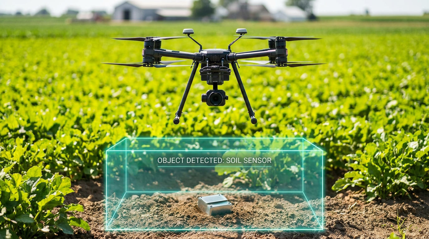
However, a newly published body of field evidence demonstrates that artificial intelligence, paired with commercial drone imagery, is fundamentally altering the mathematics of mine clearance. By automating the detection of surface-level explosives and mapping safe zones, AI is accelerating the earliest phases of demining by orders of magnitude.[1][5]
Before human deminers ever step foot in a field, organizations conduct non-technical surveys to identify suspected hazardous areas. This critical first step establishes the perimeter of danger, but the process has historically relied on slow manual observation, community interviews, and paper records.[3][8]

Recent field trials provide robust evidence that machine learning algorithms can process aerial data exponentially faster than human analysts. An 18-month study conducted in Ukraine by Norwegian People's Aid, utilizing Safe Pro Group's SpotlightAI software, recorded an 800 percent increase in survey productivity compared to traditional methods.[1][6]
The data, presented at the 2025 Geneva International Centre for Humanitarian Demining Innovation Conference, showed that teams using AI-analyzed drone imagery identified 550 percent more potentially hazardous items per hectare. Furthermore, the technology reduced labor costs for these initial surveys by approximately 50 percent, freeing up capital for the physical removal of the explosives.[1][6]
A critical vulnerability of conventional demining is its reliance on metal detectors. Modern scatterable explosives, such as the Soviet-era PFM-1 "butterfly" mine, are constructed almost entirely of plastic and are specifically designed to evade electromagnetic induction.[4]
A peer-reviewed study published in the journal Geomatics by researchers at Binghamton University demonstrates that object-detection algorithms can overcome this hardware limitation. The research team trained a "You Only Look Once" machine learning model using 3D-printed replicas and inert PFM-1 mines across various lighting and environmental conditions.[4]

When deployed on commercial drones flying 10 to 20 meters above the ground, the AI successfully identified the plastic casings of the scatterable mines. This multiview-based detection allows clearance teams to map the orientation and overlap of plastic minefields entirely from the air, without relying on metallic signatures that would otherwise register as false negatives.[4]
When deployed on commercial drones flying 10 to 20 meters above the ground, the AI successfully identified the plastic casings of the scatterable mines.
Beyond finding explosives, a significant portion of humanitarian demining involves proving that a suspected area is actually safe. Historically, vast tracts of agricultural land were quarantined simply because they were adjacent to a conflict zone, devastating local economies.[2]
The HALO Trust, the world's largest humanitarian landmine clearance organization, has integrated AI and satellite imagery to rapidly verify uncontaminated areas. By processing terabytes of drone data through Amazon Web Services and Esri's geographic information system software, the organization can forensically prove the absence of explosives.[2][5][7]
This evidence-based cancellation process has already yielded massive dividends for civilian populations. The HALO Trust reports that it has cleared over 36,000 explosives and returned 20 million square meters of land to Ukrainian families, allowing farmers to cultivate crops right up to the verified borders of actual minefields.[3][7]

Despite these breakthroughs, the technology is not a panacea, and researchers are transparent about its current limitations. The most significant weakness of current AI demining models is their inability to reliably detect buried ordnance. Algorithms trained on optical and thermal imagery struggle when mines are obscured by heavy vegetation, mud, or shifting topsoil.[2][8]
The problem with autonomy at the moment is that it struggles to cope with the depth at which the mine is laid, according to Major General James Cowan, CEO of the HALO Trust. Weather conditions, such as wet soil or heavy cloud cover, can also degrade the thermal signatures that infrared cameras rely upon to spot buried explosives.[2]
Furthermore, AI models require continuous human validation to remain safe. The algorithms are prone to false positives—flagging harmless debris as unexploded ordnance—and false negatives, which carry lethal consequences. Consequently, AI outputs are strictly used to guide human deminers and armored clearance vehicles, not replace them.[5][7]
The rapid iteration of demining technology in Eastern Europe is creating a blueprint for post-conflict recovery worldwide. The Geneva International Centre for Humanitarian Demining notes that integrating remote sensing and AI into the mine action sector will enhance evidence-based decision-making on a global scale.[8]

Technologies battle-tested in these recent conflicts are already being adapted for other contaminated regions. Organizations anticipate that these machine learning workflows will eventually accelerate clearance operations in legacy conflict zones from Cambodia to Angola, where traditional methods have stalled.[3]
Ultimately, the fusion of commercial drones and artificial intelligence represents one of the most significant humanitarian dividends of modern technology. By transforming a century-long crisis into a manageable logistical challenge, these systems are systematically returning stolen land to the people who depend on it.[1][3]
How we got here
September 2023
Safe Pro Group introduces SpotlightAi demining software and conducts initial field testing in Ukraine.
January 2024
Researchers publish peer-reviewed models for predicting landmine locations using machine learning and spatiotemporal data.
June 2024
The HALO Trust partners with AWS to process 11 terabytes of drone imagery for AI-assisted clearance.
November 2025
An 18-month field study reveals AI-analyzed drone imagery increases survey productivity by over 800%.
Viewpoints in depth
Humanitarian Demining Organizations
Focus on the safety of civilian populations, the necessity of human validation, and the rapid return of agricultural land to local farmers.
For organizations like the HALO Trust and Norwegian People's Aid, AI is a means to an end: saving lives and restoring livelihoods. They emphasize that while the technology is revolutionary for the survey phase, it cannot operate autonomously. Their primary use case for AI is 'land cancellation'—using geospatial data to definitively prove that a suspected area is free of explosives. This allows them to quickly return massive tracts of farmland to local communities without wasting months manually sweeping empty fields. They remain cautious about the technology's limitations, insisting that human experts must always validate the AI's findings to prevent lethal false negatives.
Defense Technology Developers
Emphasize the scalability of cloud computing, algorithmic efficiency, and the massive cost reductions achieved through automation.
Companies like Safe Pro Group, AWS, and Esri view the demining crisis as a massive data-processing challenge that can be solved with scalable cloud architecture. They focus on the staggering metrics of their success: 800 percent increases in productivity and 50 percent reductions in labor costs. For these developers, the goal is to ingest terabytes of drone and satellite imagery, process it through proprietary machine learning models, and deliver actionable 3D maps to operators on the ground. They argue that by automating the most tedious aspects of non-technical surveys, they are freeing up limited humanitarian capital to focus on the physical removal of the threats.
Academic Researchers
Prioritize peer-reviewed validation, sensor fusion, and overcoming edge cases like plastic casings and environmental interference.
Researchers from institutions like Binghamton University and the Geneva International Centre for Humanitarian Demining are focused on the scientific rigor of the algorithms. They are particularly interested in solving the 'edge cases' that plague traditional demining, such as detecting plastic PFM-1 'butterfly' mines that are invisible to metal detectors. Academics stress the importance of sensor fusion—combining optical, thermal, and LiDAR data—to overcome environmental variables like heavy vegetation and wet soil. They advocate for continuous, open-source training of these models using real-world data to ensure the algorithms remain robust across different global conflict zones.
What we don't know
- How effectively AI models can be trained to detect deeply buried or heavily overgrown explosives in tropical environments.
- When, or if, fully autonomous robotic clearance will be considered safe enough to operate without human validation.
- The exact false-negative rate of AI detection models across different soil types and weather conditions.
Key terms
- Non-technical survey (NTS)
- The initial phase of demining where teams identify suspected hazardous areas without physically entering them, historically done via community interviews and manual observation.
- Unexploded ordnance (UXO)
- Explosive weapons, such as bombs, shells, and grenades, that did not explode when they were deployed and still pose a lethal risk.
- Scatterable landmines
- Small explosive devices, often made of plastic, designed to be dropped from aircraft and scattered over wide areas rather than buried by hand.
- False negative
- In demining, a highly dangerous algorithmic error where an AI model fails to detect an explosive that is actually present.
Frequently asked
Does AI actually disarm the landmines?
No. AI and drones are used to safely survey, map, and identify explosives from the air. Human experts or specialized armored machines are still required to physically disarm or detonate the mines.
Why can't traditional metal detectors find all mines?
Many modern explosives, such as the PFM-1 'butterfly' mine, are encased in plastic and contain very little metal, making them nearly invisible to standard electromagnetic detectors.
How does AI save time if humans still have to clear the mines?
AI drastically speeds up the survey phase. By quickly proving which fields are empty and pinpointing the exact locations of surface mines, human teams don't have to waste months manually sweeping safe land.
Sources
Source coverage
8 outlets
3 viewpoints surfaced


[1]Euromaidan PressDefense Technology Developers
AI-powered drones deliver 800% productivity surge in Ukraine demining surveys, new research reveals
Read on Euromaidan Press →[2]National Defense MagazineDefense Technology Developers
AI, Drones Accelerating Landmine Clearance in Ukraine
Read on National Defense Magazine →[3]Geo Week NewsHumanitarian Demining Organizations
How Drones and AI Are Helping Clear 36,000 Landmines in Ukraine
Read on Geo Week News →[4]Binghamton UniversityAcademic Researchers
New technique uses AI to detect plastic landmines
Read on Binghamton University →[5]The HALO TrustHumanitarian Demining Organizations
The HALO Trust to pilot AI for landmine clearance in Ukraine with AWS support
Read on The HALO Trust →[6]Safe Pro GroupDefense Technology Developers
Safe Pro Group Introduces SpotlightAi Demining Software Platform
Read on Safe Pro Group →[7]EsriDefense Technology Developers
AI and Mine Clearance
Read on Esri →[8]Geneva International Centre for Humanitarian DeminingAcademic Researchers
What advances in technology are needed for the mine action sector?
Read on Geneva International Centre for Humanitarian Demining →
Every angle. Every day.
Get defense security stories with full source coverage and perspective breakdowns delivered to your inbox.