AI and Drone Swarms Are Revolutionizing Humanitarian Demining, Shrinking Clearance Timelines by Decades
By combining multispectral drone imagery with advanced machine learning, demining teams are mapping and clearing explosive hazards exponentially faster than traditional manual methods. The technology is transforming post-conflict recovery, returning safe land to civilians while keeping human sappers out of the blast radius.
By Factlen Editorial Team
- Humanitarian Deminers
- Focuses on practical safety and the urgent need to return agricultural land to civilians, viewing AI as a vital triage tool.
- AI & Robotics Researchers
- Focuses on the technical challenges of sensor fusion, reducing false positives, and pushing the boundaries of thermal and GPR data.
- Defense Innovators
- Focuses on the rapid iteration loop between military necessity and civilian application, emphasizing the deployment of expendable robotic platforms.
What's not represented
- · Local Farmers
- · Environmental Ecologists
Why this matters
Traditional landmine clearance is a painstakingly slow process that leaves communities in danger and agricultural land unusable for decades. This technological leap drastically accelerates the return of safe land to civilians while removing human workers from the immediate blast radius.
Key points
- Ukraine is currently the most heavily mined country in the world, with traditional clearance methods estimated to take centuries.
- Drones equipped with RGB, thermal, and GPR sensors are now mapping minefields from the air, keeping humans out of the blast radius.
- Machine learning models can detect surface and semi-surface mines with over 90% accuracy, drastically shrinking the required search grid.
- Once threats are mapped, unmanned ground vehicles (UGVs) are deployed to safely detonate the explosives.
The scale of modern explosive contamination has rendered traditional clearance methods mathematically obsolete. In Ukraine, which is currently the most heavily mined country on Earth, an estimated 170,000 to 180,000 square kilometers of territory—roughly half the size of Germany—is contaminated with landmines and unexploded ordnance. Relying solely on conventional sapper teams equipped with handheld metal detectors and probing rods, researchers estimate it would take 757 years and tens of billions of dollars to fully clear the country. This staggering timeline has catalyzed a rapid, life-saving pivot in military and humanitarian technology: the deployment of artificial intelligence and autonomous drone swarms to map and clear minefields exponentially faster than humanly possible.[1][6][7]
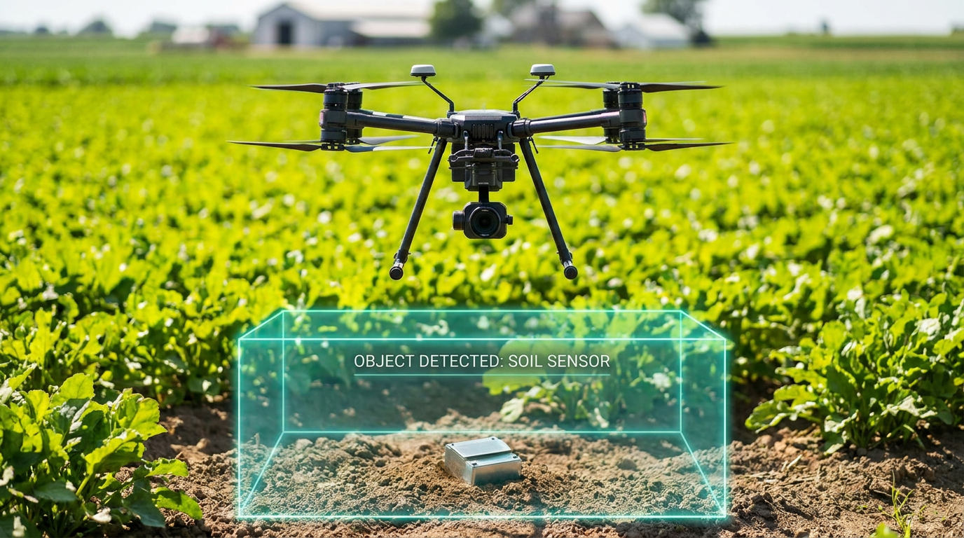
The breakthrough lies in decoupling the detection phase from the physical clearance phase, removing humans from the immediate blast radius. Historically, deminers had to slowly crawl through suspected hazardous areas, treating every square inch as a potential threat. Today, commercial and custom-built drones fly over these zones, capturing high-resolution multispectral data. This aerial reconnaissance fundamentally changes the equation, allowing clearance teams to shrink the search grid from the size of a football pitch down to a few specific square meters before anyone sets foot in the field.[1][2][6][8]
The mechanism relies on a fusion of advanced sensors and machine learning algorithms. Drones are equipped with a combination of RGB (visual) cameras, thermal imaging, magnetometers, and increasingly, Ground Penetrating Radar (GPR). As the drone sweeps the area, it feeds gigabytes of sensor data into a neural network trained on hundreds of thousands of images of explosive devices. The AI processes this data in minutes, generating a precise, color-coded digital map that highlights the exact GPS coordinates of probable threats.[1][6][7][8]

The empirical evidence supporting AI detection of surface and semi-surface mines is highly robust. A foundational study published in the Journal of Conventional Weapons Destruction demonstrated the efficacy of using region-based convolutional neural networks (R-CNN) to identify scatterable munitions like the PFM-1 'butterfly' mine. While early proof-of-concept trials achieved a 71.5% detection rate, subsequent expansions of the training dataset pushed the AI's accuracy to 91.8% using standard visual drone imagery. This established drone-based machine learning as a viable 'first look' area reduction technique for humanitarian operations.[4]
Recent advancements in computer vision have further refined this capability. A 2024 study evaluating deep learning-based object detection models on drone flyby datasets found that modern architectures, specifically the YOLOF (You Only Look One-level Feature) model, significantly outperformed older systems. When analyzing drone footage taken from 10 meters above ground level, the YOLOF model achieved a mean Average Precision (mAP) score of 0.89 for detecting small, soda-can-sized surface mines. These models are also becoming computationally lighter, allowing them to run in real-time on mobile devices in the field.[3]
Visual cameras, however, are limited by dense vegetation and camouflage. To counter this, researchers have successfully integrated thermal imaging to detect the distinct thermodynamic signatures of buried or obscured explosives. A 2026 study utilizing unmanned aerial vehicles equipped with infrared cameras and a MobileNetV3-Large deep learning architecture reported a test accuracy of 96.14%. Because metal and plastic casings absorb and radiate heat differently than surrounding soil and vegetation, the thermal AI models can identify anomalies that are entirely invisible to the naked eye.[5]

Visual cameras, however, are limited by dense vegetation and camouflage.
These academic breakthroughs are already translating into measurable field results. In Kyiv, defense tech startups and humanitarian organizations have partnered to deploy these systems in active recovery zones. Companies like UADamage and Dropla Tech are utilizing multi-sensor drones that analyze magnetic field maps and visual data to automatically detect explosive objects without human intervention. In messy, real-world conditions, these proprietary AI models are currently achieving around 80% to 85% accuracy, a figure that steadily improves as the algorithms ingest more field data.[1][6][7][8]
The rapid progress in this field is heavily supported by the open-source community. Researchers are increasingly publishing comprehensive datasets of drone flybys, complete with thousands of annotated images of various munitions. By making these datasets publicly available, institutions enable computer vision scientists worldwide to train, test, and compare different foundation models, accelerating the collective accuracy of the technology. This collaborative approach ensures that humanitarian organizations are not locked into single-vendor solutions, but can leverage the best available algorithms.[3]
Despite these massive leaps, transparent uncertainty remains regarding deeply buried threats and complex environments. Industry experts caution that while AI is highly effective for surface, semi-surface, and recently deployed mines, it struggles with older munitions buried deep underground or hidden beneath thick forest canopies. Environmental factors like heavy rain, mud, and seasonal vegetation changes can alter the thermal and visual signatures of explosives, occasionally leading to false positives or missed detections.[5][8]
To address the subsurface challenge, engineers are actively developing drone-mounted Ground Penetrating Radar (GPR). GPR transmits electromagnetic pulses into the soil and analyzes the reflected signals to detect hidden cavities and buried casings. However, interpreting GPR data from a moving aerial platform remains computationally complex, as the drone's vibration and magnetic noise can interfere with the delicate sensors. While promising, aerial GPR integration is still considered an emerging frontier rather than a fully solved problem.[5][6][8]

Because of these limitations, developers are clear that AI is an auxiliary tool, not a wholesale replacement for human expertise. The technology is designed to analyze aerial data and identify high-risk zones, drastically reducing the time sappers spend in dangerous areas. As one strategist noted, no AI system can fully replace the judgment of a trained deminer; rather, it acts as an advanced triage system that tells the clearance team exactly where to focus their efforts.[8]
Once the AI has mapped the threats, the physical clearance is increasingly handed off to unmanned ground vehicles (UGVs). Robotic platforms, ranging from the heavy-duty Armtrac 400 to the nimble Ukrainian-developed Zmiy system, are deployed to the exact coordinates flagged by the drone. These armored vehicles use flails, tillers, and mine rollers to churn the earth and safely detonate the explosives while the human operator controls the machine from a safe distance.[1][2]
This synergy of aerial AI mapping and robotic ground clearance is transforming the economics and safety profile of humanitarian demining. By eliminating the need to manually sweep empty fields, clearance operations can bypass the vast majority of uncontaminated land. This targeted approach not only saves lives but dramatically accelerates the timeline for returning agricultural land to farmers and allowing displaced communities to safely rebuild.[1][2]
The rapid evolution of these systems represents a profound silver lining in modern conflict recovery. Technologies originally developed for military reconnaissance and targeting are being successfully inverted to heal scarred landscapes and protect civilian populations. As these AI models become more sophisticated and robotic platforms more accessible, the tools forged in today's minefields will set a new, life-saving standard for global humanitarian demining for decades to come.[1][7][8]
How we got here
2021
Early proof-of-concept studies demonstrate convolutional neural networks can detect surface mines from drone imagery with over 70% accuracy.
2022–2023
The massive scale of explosive contamination in Ukraine accelerates global investment in autonomous demining technology.
2024
Advanced object detection models achieve near 90% accuracy for surface threats in field tests, running in real-time on mobile devices.
2025–2026
Multi-sensor drones integrating thermal imaging and ground-penetrating radar are deployed in active humanitarian recovery zones.
Viewpoints in depth
Humanitarian Deminers
Focuses on practical safety and the urgent need to return agricultural land to civilians.
For humanitarian organizations, the primary metric of success is the speed and safety with which land can be returned to local communities. They view AI not as a silver bullet that replaces human judgment, but as a critical triage tool. By identifying exactly where the threats are—and more importantly, where they are not—clearance teams can bypass vast tracts of uncontaminated land, shrinking a process that would normally take decades into a matter of years.
AI & Robotics Researchers
Focuses on the technical challenges of sensor fusion and pushing the boundaries of subsurface detection.
Computer vision scientists and robotics engineers are focused on the empirical limits of the technology. While surface detection using RGB and thermal imaging has reached high levels of accuracy, researchers are actively working to solve the 'subsurface challenge.' They emphasize the need for better open-source datasets and are currently iterating on the complex computational task of interpreting Ground Penetrating Radar (GPR) data from moving aerial platforms to detect deeply buried, older munitions.
Defense Innovators
Focuses on the rapid iteration loop between military necessity and civilian application.
Defense technology startups view the current landscape as a laboratory for rapid innovation. They prioritize the deployment of expendable, cost-effective robotic platforms that can be easily manufactured and fielded. Their philosophy is that losing a drone or a robotic ground vehicle to an unexpected detonation is a successful outcome, provided it keeps human sappers out of harm's way. This group is actively bridging the gap between military reconnaissance tech and civilian life-saving applications.
What we don't know
- How effectively drone-mounted Ground Penetrating Radar (GPR) will perform on deeply buried, decades-old munitions in varied soil types.
- The exact rate of false positives generated by AI models when operating in extreme weather conditions or dense forest canopies.
Key terms
- UXO
- Unexploded Ordnance; explosive weapons that did not explode when they were deployed and still pose a risk of detonation.
- GPR
- Ground Penetrating Radar; a geophysical method that uses radar pulses to image the subsurface and detect buried objects.
- R-CNN
- Region-based Convolutional Neural Network; a type of machine learning model highly effective at object detection in images.
- UGV
- Unmanned Ground Vehicle; a robotic platform that operates on the ground without an onboard human presence, often used for physical mine clearance.
Frequently asked
Can AI detect mines that are buried underground?
AI is highly effective at finding surface and semi-surface mines, but deeply buried munitions remain a challenge. Researchers are currently integrating Ground Penetrating Radar (GPR) to improve subsurface detection.
Does this technology replace human deminers?
No. AI acts as an advanced mapping and triage tool to identify high-risk zones, but trained human experts and robotic ground vehicles are still required to safely neutralize the threats.
How much faster is drone-assisted demining?
By mapping the exact locations of threats from the air, clearance teams can bypass uncontaminated land entirely, shrinking clearance timelines for heavily mined areas from decades to a matter of years.
Sources
Source coverage
8 outlets
3 viewpoints surfaced


[1]ForbesDefense Innovators
Inside The Race To Clear Ukraine's Minefields With Robots And AI
Read on Forbes →[2]UN NewsHumanitarian Deminers
Deminers race to keep up with military technology
Read on UN News →[3]arXivAI & Robotics Researchers
Comparing Surface Landmine Object Detection Models on a New Drone Flyby Dataset
Read on arXiv →[4]Journal of Conventional Weapons DestructionAI & Robotics Researchers
How to Implement Drones and Machine Learning to Reduce Time, Costs, and Dangers Associated with Landmine Detection
Read on Journal of Conventional Weapons Destruction →[5]ResearchGateAI & Robotics Researchers
Advancements in Landmine Detection: Deep Learning-Based Analysis With Thermal Drones
Read on ResearchGate →[6]MilitarnyiDefense Innovators
Ukraine Develops AI Drone for Mine Detection
Read on Militarnyi →[7]Euromaidan PressDefense Innovators
Kyiv's AI coders take aim at hidden Russia's killers beneath soil
Read on Euromaidan Press →[8]SubSphereHumanitarian Deminers
AI and humanitarian demining: An interview with Shahab Moeini
Read on SubSphere →
Every angle. Every day.
Get defense security stories with full source coverage and perspective breakdowns delivered to your inbox.