The Rise of Civilian OSINT: How Open-Source Intelligence is Exposing Environmental Crime
High-resolution satellite imagery and AI-driven data platforms are democratizing intelligence gathering, empowering NGOs and journalists to track illegal fishing and deforestation in real time.
By Factlen Editorial Team
- Open-Source Investigators
- Argue that democratized intelligence is essential for holding both criminals and complacent governments accountable through radical transparency.
- Commercial Data Providers
- Focus on the technological breakthroughs in satellite hardware and AI that make persistent global monitoring commercially viable.
- State Law Enforcement
- Acknowledge the value of civilian intelligence but emphasize that physical interdiction and legal prosecution still require state authority.
What's not represented
- · Local indigenous communities directly affected by illegal logging
- · State intelligence agencies adapting to the loss of their information monopoly
Why this matters
By stripping eco-criminals of their anonymity, civilian open-source intelligence is cutting off the financial flows of illicit networks. It allows local communities and NGOs to protect natural resources without relying solely on slow-moving state enforcement.
Key points
- Commercial satellite constellations now provide daily, high-resolution images of the entire Earth.
- Civilian OSINT platforms allow NGOs to track illegal fishing vessels even when they turn off their transponders.
- Investigators are successfully mapping illicit timber supply chains from remote forests to global markets.
- Artificial intelligence is automating the analysis of massive satellite datasets to flag environmental crimes instantly.
- This democratization of intelligence shifts power from state monopolies to civilian watchdogs.
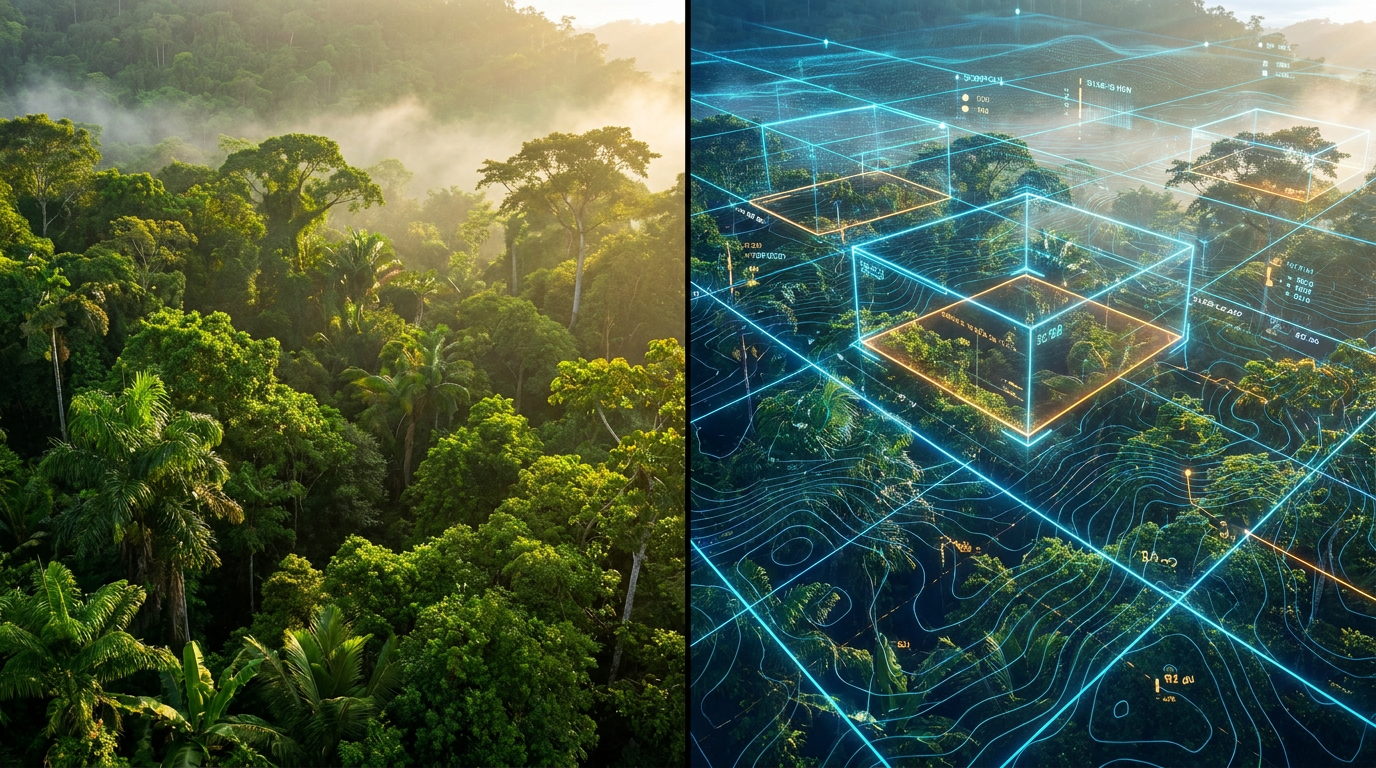
For decades, the ability to monitor the Earth from above was a closely guarded monopoly held by a handful of superpower intelligence agencies. Tracking a ship across the open ocean or spotting a clandestine logging camp deep in a rainforest required billions of dollars in classified satellite infrastructure. Today, that paradigm has entirely inverted. The proliferation of commercial satellites and open-source intelligence (OSINT) platforms has democratized global surveillance, placing military-grade analytical power into the hands of civilian researchers, journalists, and environmental watchdogs.[4][6]
The stakes for this technological shift are immense. Environmental crime—encompassing illegal logging, unregulated fishing, and illicit mining—has quietly grown into the fourth most lucrative criminal enterprise on the planet, trailing only drug trafficking, counterfeiting, and human trafficking. These illicit economies thrive in the world's blind spots: the vast, unpoliced expanses of the high seas and remote, dense jungles where traditional law enforcement struggles to maintain a physical presence.[1]
But those blind spots are rapidly shrinking. The catalyst for this transparency is the explosion of the commercial satellite industry. Companies like Planet Labs have deployed constellations of over 200 low-cost "Dove" satellites, which collectively photograph the entire landmass of the Earth every single day. This persistent, daily coverage was unimaginable even fifteen years ago, and the resolution of these commercial images has sharpened to 30 centimeters—enough to identify individual vehicles and heavy machinery from orbit.[4]
This persistent overhead gaze is providing the foundational evidence for a new era of civilian accountability. The primary claim among OSINT advocates is that "dark fleets"—vessels that deliberately disable their tracking transponders to engage in illegal fishing or sanctions evasion—can no longer hide at sea. The evidence for this claim is robust and increasingly accessible to the public.[3][6]

Global Fishing Watch, a non-profit platform dedicated to ocean governance, exemplifies this capability. Historically, ships engaged in illegal, unreported, and unregulated (IUU) fishing would simply turn off their Automatic Identification System (AIS) to vanish from public tracking maps. However, Global Fishing Watch now cross-references AIS data with satellite-detected radar and optical imagery to spot vessels even when they are not broadcasting.[3]
In 2025, the platform integrated high-resolution imagery directly into its interface. This upgrade lowered the detection threshold dramatically, allowing analysts to spot "dark" vessels as small as three meters operating in coastal waters. By automatically flagging suspicious behavior patterns—such as sudden AIS gaps in protected waters or rendezvous events where ships transfer illegal catches at sea—the platform provides undeniable proof of illicit activity.[3]
In 2025, the platform integrated high-resolution imagery directly into its interface.
A second major claim is that OSINT tools are successfully mapping and disrupting the complex supply chains of illegal timber. The Environmental Investigation Agency (EIA), an independent NGO, has utilized these tools to trace the flow of stolen trees from protected forests in Africa and Southeast Asia to wholesale markets in China. This trade is typically obscured by a labyrinth of shell companies, corrupt officials, and falsified manifests.[2]
To pierce this corporate veil, civilian analysts combine satellite imagery with digital forensics. Using platforms like OSINT Industries, investigators cross-reference corporate registries, reverse phone lookups, and social media footprints to map the criminal networks driving the deforestation. This fusion of geospatial data and digital breadcrumbs allows NGOs to name complicit companies and trace smuggling routes with unprecedented speed.[2]

The sheer volume of data generated by daily satellite passes and global tracking systems is too massive for human analysts to process manually. This introduces the third major claim: Artificial Intelligence is now the critical engine for automating the detection of environmental crimes. Geospatial AI (GeoAI) platforms are bridging the gap between raw data and actionable intelligence.[5][6]
Companies like Picterra deploy machine learning algorithms that scan thousands of square miles of satellite imagery in minutes. These models are trained to automatically detect the subtle signatures of illegal logging roads, the sudden appearance of artisanal mining pits, or the specific spectral footprint of deforestation. By turning raw pixels into structured alerts, AI ensures that environmental watchdogs are notified the moment a protected boundary is breached.[5]
This democratization of intelligence represents a profound shift in global power dynamics. Non-state actors now possess the capability to track troop movements, expose covert actions, and monitor environmental degradation in near-real time. The capability gap between well-resourced state intelligence services and civilian organizations is narrowing, forcing a fundamental reassessment of how global security and conservation are managed.[4][6]
Despite these technological triumphs, transparent uncertainty remains regarding the "last mile" of enforcement. OSINT can provide irrefutable evidence of a crime, but it cannot arrest a poacher or seize a smuggling vessel. The translation of open-source intelligence into physical interdiction still relies on the political will and operational capacity of state law enforcement agencies, which are often underfunded or compromised by corruption.[1][6]

Furthermore, the tools themselves are not infallible. While radar can see through clouds, optical satellites are still hindered by weather. Additionally, as AI models become mainstream in OSINT workflows, there is a recognized risk of "hallucinations"—where models fed unverified data produce confident but inaccurate intelligence. Quality-tagged source data remains a strict precondition for responsible analysis.[3][6]
Nevertheless, the trajectory is clear. The architecture of global environmental protection is moving from a closed, state-centric model to an open, community-driven panopticon. By distributing situational awareness to the masses, civilian OSINT is ensuring that the destruction of the global commons can no longer happen in the dark.[6]
How we got here
2010
Planet Labs is founded with the goal of launching low-cost 'Dove' satellites to photograph the Earth daily.
2013
The Global Initiative Against Transnational Organized Crime is established to build an analytical evidence base against illicit networks.
2024
The EU Environmental Crime Directive enters into force, introducing stricter sanctions and recognizing the scale of eco-crimes.
2025
Global Fishing Watch integrates high-resolution Planet Labs imagery, allowing the tracking of vessels as small as three meters.
2026
AI-assisted OSINT becomes a mainstream requirement for processing the overwhelming volume of daily commercial satellite data.
Viewpoints in depth
Open-Source Investigators' view
Democratized intelligence is the ultimate tool for global accountability.
For NGOs and investigative journalists, the explosion of OSINT tools represents a leveling of the playing field. They argue that state actors have historically been too slow, too bureaucratic, or too politically compromised to effectively police environmental crimes in remote areas. By leveraging public data, these investigators can bypass diplomatic red tape, directly name complicit corporations, and publish undeniable visual evidence of crimes as they happen, forcing governments and markets to react.
Commercial Data Providers' view
Technology has solved the collection problem; the focus is now on analysis.
The companies building the satellites and the AI models view the current era as a triumph of commercial innovation. They emphasize that launching a satellite is no longer the bottleneck—the challenge is processing the petabytes of data beaming down every day. Their focus is on refining machine learning algorithms to reduce false positives and creating user-friendly interfaces that allow anyone, regardless of technical background, to query the physical world as easily as searching the web.
State Law Enforcement's view
Intelligence is only half the battle; physical enforcement remains the bottleneck.
While traditional law enforcement and intelligence agencies welcome the influx of high-quality civilian data, they caution against viewing OSINT as a panacea. They point out that identifying a 'dark' fishing vessel on a monitor does not automatically result in an arrest. Interdicting armed smugglers or shutting down illegal mines requires physical jurisdiction, trained personnel, and the political will to prosecute—elements that cannot be downloaded from a satellite feed.
What we don't know
- How quickly criminal syndicates will develop new countermeasures to spoof or evade AI-driven satellite tracking.
- Whether international courts will universally accept AI-processed commercial satellite imagery as definitive legal evidence.
- How the proliferation of open-source intelligence will alter the behavior of state-sponsored intelligence agencies.
Key terms
- OSINT
- Open-Source Intelligence; the practice of collecting and analyzing publicly available data to uncover hidden networks or track events.
- AIS
- Automatic Identification System; a tracking system that uses transceivers on ships to broadcast their location, speed, and heading.
- Dark Fleet
- A network of vessels that deliberately disable their tracking transponders to engage in illicit activities like illegal fishing or sanctions evasion.
- GeoAI
- Geospatial Artificial Intelligence; the application of machine learning to analyze and extract patterns from satellite and aerial imagery.
- Synthetic Aperture Radar (SAR)
- A form of radar used to create detailed 2D images or 3D reconstructions of landscapes, uniquely capable of seeing through clouds and darkness.
Frequently asked
What is Open-Source Intelligence (OSINT)?
OSINT is the collection and analysis of information that is publicly or commercially available, such as satellite imagery, public corporate records, and social media data, used to generate actionable intelligence.
How do illegal fishing vessels hide their locations?
Ships often engage in 'dark shipping' by deliberately turning off their Automatic Identification System (AIS) transponders, which legally mandates them to broadcast their location to surrounding vessels and authorities.
How does AI help track deforestation?
Geospatial AI (GeoAI) algorithms are trained to scan massive amounts of daily satellite imagery to automatically detect the visual signatures of new logging roads, missing tree canopies, or mining pits, alerting analysts instantly.
Can civilians really access military-grade satellite images?
Yes. Commercial satellite companies now offer imagery with resolutions as sharp as 30 centimeters, updated daily, which was a capability exclusively held by superpower intelligence agencies just 15 years ago.
Sources
Source coverage
6 outlets
3 viewpoints surfaced


[1]Global Initiative Against Transnational Organized CrimeState Law Enforcement
Organized Crime and Environmental Degradation: The Intersections
Read on Global Initiative Against Transnational Organized Crime →[2]OSINT IndustriesOpen-Source Investigators
Global Timber Crime: Unmasking the Networks
Read on OSINT Industries →[3]Adria DefenseOpen-Source Investigators
10 Free OSINT Tools Every Defence Analyst Should Be Using in 2026
Read on Adria Defense →[4]National Defense Space ShowCommercial Data Providers
Commercial Satellite Imagery Changes Everything
Read on National Defense Space Show →[5]PicterraCommercial Data Providers
Uncovering ground truth: Using GeoAI in OSINT & investigative journalism
Read on Picterra →[6]Factlen Editorial Team
Synthesis by Factlen editorial team
Read on Factlen Editorial Team →
Every angle. Every day.
Get defense security stories with full source coverage and perspective breakdowns delivered to your inbox.