How Open-Source Intelligence is Democratizing Global Environmental Protection
Civilian analysts and NGOs are using commercial satellite data and open-source intelligence to successfully track and deter illegal fishing, deforestation, and wildlife crimes.
By Factlen Editorial Team
- Civil Society Investigators
- Argue that open-source data democratizes accountability and empowers citizens to protect the environment.
- Conservation Technologists
- Focus on the technical capabilities of satellite imagery and AI to monitor vast, remote ecosystems efficiently.
- Legal Standards Advocates
- Emphasize that raw intelligence must be rigorously authenticated to meet evidentiary standards in international courts.
- Maritime Security Analysts
- View OSINT as a critical tool for tracking sanctions evasion and illicit supply chains that traditional state patrols miss.
What's not represented
- · Local enforcement agencies lacking the budget to access premium commercial satellite data.
- · Small-scale artisanal fishers who may be misidentified by automated tracking algorithms.
Why this matters
The ability to monitor the Earth from space is no longer monopolized by state intelligence agencies. By empowering citizens and NGOs to track environmental crimes in real-time, open-source intelligence is creating a powerful new deterrent against illegal activities that previously thrived in the shadows.
Key points
- Commercial satellites and open-source data have ended state monopolies on global surveillance.
- NGOs use Synthetic Aperture Radar (SAR) to track illegal fishing vessels that disable their transponders.
- A 2025 study found that 96% of fully protected marine areas successfully deter industrial fishing.
- High-revisit satellite constellations allow civilian analysts to track deforestation and mining in near real-time.
- The Berkeley Protocol provides a legal framework to ensure open-source intelligence is admissible in court.
For decades, the ability to monitor the Earth from above was the exclusive domain of state intelligence agencies. Multibillion-dollar satellite networks were classified assets, used by superpowers to track troop movements and nuclear silos. Today, that monopoly has evaporated. A proliferation of commercial satellites and open-source data has democratized global surveillance, placing tools once reserved for government operatives into the hands of journalists, researchers, and environmental watchdogs.[6]
This shift has given rise to a new discipline: Open-Source Intelligence, or OSINT. By aggregating publicly available data—from social media metadata to shipping registries and commercial satellite imagery—civilian analysts can now track illicit activities across the globe. While OSINT gained public prominence for its role in conflict zones, its most transformative application is quietly unfolding in the natural world, where it is being used to combat environmental crimes that previously went undetected.[3][4]
Environmental and Climate Open-Source Intelligence (ECOSINT) is reshaping how non-governmental organizations protect vulnerable ecosystems. The core premise is simple but powerful: environmental destruction, whether illegal logging in the Amazon or illicit fishing in the Pacific, leaves a digital footprint. By combining multiple streams of open-source data, civilian investigators can build comprehensive evidence packs that expose these activities in near real-time.[3][4]
The most striking evidence of OSINT's efficacy comes from the open ocean. Historically, monitoring marine protected areas was a logistical nightmare. National navies and coast guards relied on costly physical patrols across millions of square miles of water, leaving vast stretches unmonitored. Illegal fishing fleets exploited this gap, operating with impunity in remote sanctuaries.[1]

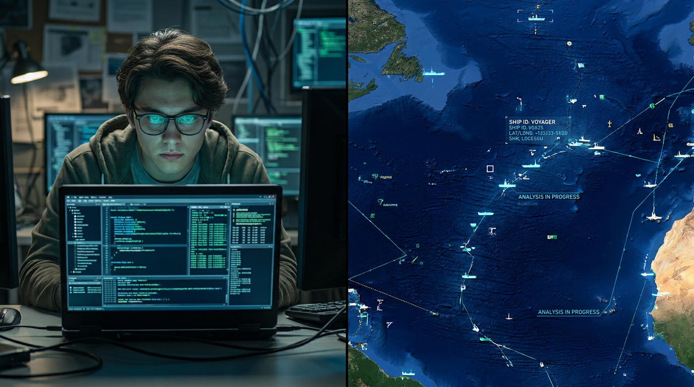
To evade detection, illicit vessels routinely disable their Automatic Identification System (AIS)—the transponders required by international law to broadcast a ship's identity and location. When a ship goes "dark," it disappears from conventional maritime tracking platforms. However, organizations like Global Fishing Watch have developed methodologies to illuminate these blind spots using Synthetic Aperture Radar (SAR).[2][8]
Unlike traditional optical satellites, which are blinded by clouds and darkness, SAR bounces microwave signals off the Earth's surface. Metal structures, such as the hulls of industrial fishing trawlers, reflect these signals strongly, appearing as bright pixels on a radar map. By cross-referencing these radar detections with public AIS data, analysts can instantly identify vessels that are physically present but electronically silent.[2][8]
The scale of this data processing is staggering. In a recent initiative, Global Fishing Watch analyzed the entire archive of Sentinel-1 radar imagery, making 20 million detections of sea-going vessels and matching them against 100 billion GPS points. This multi-layered approach allows conservationists to pinpoint exactly where "dark fleets" are operating, transforming ocean conservation from a guessing game into a precise science.[2]
The impact of this transparency is quantifiable. A July 2025 study published in the journal Science analyzed nearly 1,400 marine protected areas spanning 3 million square miles. The researchers combined AIS vessel tracking, SAR imagery, and official maritime rules to measure compliance. The evidence revealed that marine sanctuaries where industrial fishing is explicitly banned are largely succeeding at preventing poaching.[1]

A July 2025 study published in the journal Science analyzed nearly 1,400 marine protected areas spanning 3 million square miles.
The data showed an average of just five fishing vessels per 100,000 square kilometers in protected areas, compared to 42 in unprotected coastal zones. Crucially, 96% of the fully protected areas experienced less than one day per year of alleged illegal fishing effort. The knowledge that they are being watched from space—even with their transponders off—has created a powerful deterrent effect among industrial fleets.[1]
Beyond the oceans, ECOSINT is proving equally disruptive on land. The Nature Crime Alliance reports that civil society organizations are increasingly using high-resolution satellite imagery to detect unauthorized mining, monitor oil spills, and identify illegal logging patterns. Commercial operators like Planet Labs now maintain constellations of hundreds of nano-satellites, capable of imaging the entire landmass of the Earth every single day.[3][7]
This high-revisit rate allows analysts to track environmental degradation in near real-time. If a new logging road is carved into a protected forest, or a mining camp expands into indigenous territory, the changes are captured and archived within 24 hours. When triangulated with other open-source data—such as corporate records, export permits, and social media posts from workers—these images form a robust chain of evidence.[3][7]

Bellingcat, an investigative collective famous for its conflict reporting, has aggressively expanded into environmental OSINT. The organization trains journalists and activists to use geospatial data to map land use and track the logistics networks of extractive industries. By following the digital breadcrumbs of shipping and trade databases, investigators can link environmental destruction directly to the corporations and supply chains profiting from it.[4]
However, the rapid democratization of intelligence gathering has introduced a critical challenge: the "Evidence Standard Problem." There is a significant gap between information that has intelligence value and information that is admissible in a court of law. A satellite image showing a dark vessel in a protected zone is a powerful intelligence lead, but prosecuting the vessel's owners requires rigorous authentication.[5]
To address this, the legal and human rights communities are working to standardize OSINT methodologies. The Berkeley Protocol on Digital Open Source Investigations, published by the UN Office of the High Commissioner for Human Rights and UC Berkeley, provides a comprehensive framework for collecting, preserving, and analyzing digital evidence.[5]

The protocol dictates strict standards for time-stamping, geotagging, and securely storing open-source data to ensure its integrity is maintained from the moment of discovery to its presentation in a courtroom. As these legal frameworks mature, the barrier between citizen journalism and formal legal accountability is steadily eroding.[5]
The democratization of intelligence represents a structural shift in global security and environmental protection. Bad actors can no longer rely on the vastness of the ocean or the remoteness of a jungle to conceal their activities. The proliferation of open-source data has created a decentralized, global network of watchdogs, armed with tools that rival the capabilities of nation-states.[6][7]
For environmental conservation, this transparency is a game-changer. It shifts the burden of enforcement from underfunded local agencies to a global community of analysts, researchers, and algorithms. As satellite technology becomes cheaper and AI-driven analysis becomes more accessible, the digital dragnet will only grow tighter, offering a powerful new mechanism for protecting the planet's most vulnerable ecosystems.[2][6]
How we got here
2014
Bellingcat is founded, popularizing the use of open-source intelligence by citizen journalists.
2015
Commercial nano-satellite constellations begin providing daily, high-resolution imagery of the entire Earth.
2022
The UN and UC Berkeley publish the Berkeley Protocol to standardize digital open-source investigations for legal use.
2024
Global Fishing Watch maps 20 million 'dark vessel' detections using Synthetic Aperture Radar.
July 2025
A landmark study in Science confirms that OSINT tracking deters illegal fishing in 96% of fully protected marine areas.
Viewpoints in depth
Civil Society Investigators
Open-source intelligence shifts power from state monopolies to public watchdogs.
For organizations like Bellingcat and the Nature Crime Alliance, the proliferation of commercial satellite data is a democratizing force. They argue that environmental crimes thrive in the shadows, often protected by underfunded local enforcement or corrupt officials. By training a global network of citizen journalists to analyze trade databases and high-resolution imagery, these groups believe they can create an unavoidable web of accountability, forcing extractive industries and illegal fleets to operate in the open.
Conservation Technologists
AI and remote sensing are the only scalable ways to monitor the planet's vast ecosystems.
Technologists at Planet Labs and Global Fishing Watch emphasize the sheer scale of the monitoring challenge. The ocean is too vast for physical naval patrols to be effective. Instead, they champion a data-first approach, combining Synthetic Aperture Radar (SAR) with machine learning algorithms to process billions of GPS points. Their evidence suggests that the mere knowledge of being tracked from space creates a powerful deterrent effect, drastically reducing poaching in marine protected areas without firing a single shot.
Legal Standards Advocates
Intelligence is only useful if it can survive the rigorous scrutiny of a courtroom.
Legal experts, including those behind the Berkeley Protocol, caution against treating raw open-source data as definitive proof. They highlight the 'Evidence Standard Problem'—the reality that a compelling satellite image on social media is often inadmissible in court due to chain-of-custody issues. This camp focuses on establishing strict cryptographic and methodological standards for OSINT, ensuring that digital evidence of environmental crimes can actually lead to successful prosecutions rather than just public awareness.
What we don't know
- Whether international courts will universally accept OSINT evidence gathered by non-state actors.
- How illegal fleets will adapt their evasion tactics as satellite tracking becomes ubiquitous.
- The long-term funding sustainability for NGOs relying on expensive commercial satellite data.
Key terms
- Open-Source Intelligence (OSINT)
- Intelligence gathered from publicly available sources rather than classified or covert collection methods.
- Synthetic Aperture Radar (SAR)
- A form of radar used to create two-dimensional images or three-dimensional reconstructions of landscapes, capable of penetrating clouds and darkness.
- Automatic Identification System (AIS)
- An automated tracking system used on ships to broadcast their identity, position, course, and speed to avoid collisions.
- Dark Vessel
- A ship that has intentionally disabled its AIS transponder to evade detection, often to engage in illegal activities.
- The Berkeley Protocol
- A set of international guidelines for the ethical and legally admissible collection of digital open-source information.
Frequently asked
What is Open-Source Intelligence (OSINT)?
OSINT is the collection and analysis of publicly available information—such as satellite imagery, social media, and trade databases—to gather actionable intelligence.
How do satellites track ships that turn off their transponders?
Analysts use Synthetic Aperture Radar (SAR), which bounces microwave signals off the Earth. Metal ship hulls reflect these signals, allowing them to be detected even through clouds or darkness.
What is ECOSINT?
ECOSINT stands for Environmental and Climate Open-Source Intelligence. It applies OSINT techniques to track environmental crimes like illegal logging, poaching, and unauthorized mining.
Can open-source evidence be used in court?
Yes, but it must meet strict legal standards. Frameworks like the Berkeley Protocol help investigators properly time-stamp, geotag, and preserve digital data so it is admissible in legal proceedings.
Sources
Source coverage
8 outlets
4 viewpoints surfaced


[1]ScienceConservation Technologists
Satellite tracking reveals efficacy of marine protected areas against industrial fishing
Read on Science →[2]Global Fishing WatchConservation Technologists
Tracking Dark Vessels with Synthetic Aperture Radar
Read on Global Fishing Watch →[3]Nature Crime AllianceCivil Society Investigators
The Role of Civil Society Organizations in Environmental Crime Investigations
Read on Nature Crime Alliance →[4]BellingcatCivil Society Investigators
ECOSINT: Environmental and Climate Open-Source Intelligence
Read on Bellingcat →[5]UC Berkeley Human Rights CenterLegal Standards Advocates
The Berkeley Protocol on Digital Open Source Investigations
Read on UC Berkeley Human Rights Center →[6]Factlen Editorial TeamMaritime Security Analysts
Synthesis by Factlen editorial team
Read on Factlen Editorial Team →[7]Planet LabsConservation Technologists
Democratizing Earth Observation Data for Civil Society
Read on Planet Labs →[8]Center for Advanced Defense Studies (C4ADS)Maritime Security Analysts
Maritime OSINT and AIS Manipulation
Read on Center for Advanced Defense Studies (C4ADS) →
Every angle. Every day.
Get defense security stories with full source coverage and perspective breakdowns delivered to your inbox.