How North America is Stitching Its Fragmented Ecosystems Back Together
A massive boom in cross-border wildlife corridors and high-resolution mapping is reconnecting the continent, drastically reducing highway collisions and saving isolated species.
By Factlen Editorial Team
- Conservation Scientists
- Focuses on genetic diversity, climate resilience, and the necessity of mapping ecological pinch points.
- Indigenous Land Stewards
- Prioritizes traditional ecological knowledge and the creation of large-scale Indigenous Protected and Conserved Areas.
- Transportation & Safety Officials
- Views wildlife corridors primarily as highly effective infrastructure investments that save human lives and reduce economic costs.
- Private Landowners
- Advocates for voluntary conservation easements that maintain working ranches while allowing wildlife passage.
What's not represented
- · Auto insurance industry actuaries
- · Highway construction contractors
Why this matters
As climate change forces species to migrate, isolated national parks are no longer enough to prevent mass extinctions. The construction of wildlife corridors not only ensures the survival of iconic North American species but also saves taxpayers billions by drastically reducing fatal vehicle collisions.
Key points
- North America is undergoing a massive infrastructure boom focused on building wildlife corridors to reconnect fragmented ecosystems.
- The Yellowstone to Yukon initiative has successfully completed over 204 wildlife crossings, reducing animal-vehicle collisions by up to 96 percent.
- A new 2026 study provides the first seamless, high-resolution map of ecological connectivity across the U.S.-Canada border.
- Only 19 percent of the continent's most vital transboundary wildlife pathways are currently located within strictly protected government lands.
- Corridors are essential for climate resilience, allowing species to migrate north or to higher elevations as global temperatures rise.
In the early 1990s, a radio-collared grey wolf named Pluie embarked on a journey that fundamentally altered how scientists view North American geography. Over two years, Pluie covered an astonishing 40,000 square miles across the Rocky Mountains, crossing three U.S. states, two Canadian provinces, and dozens of Indigenous territories. Her epic trek highlighted a glaring flaw in modern environmental stewardship: nature does not recognize political borders, yet human protection systems are entirely defined by them. For decades, the prevailing strategy was to draw a line around a spectacular landscape, declare it a national park, and assume the wildlife inside would thrive. But as human development encroached on the edges of these protected islands, scientists realized that isolated parks were slowly suffocating. Animals could no longer migrate to find food, track shifting climates, or mix with other populations to maintain genetic diversity. Pluie’s journey sparked a paradigm shift from protecting isolated islands of habitat to preserving the vast, interconnected pathways between them.[3][5][6]
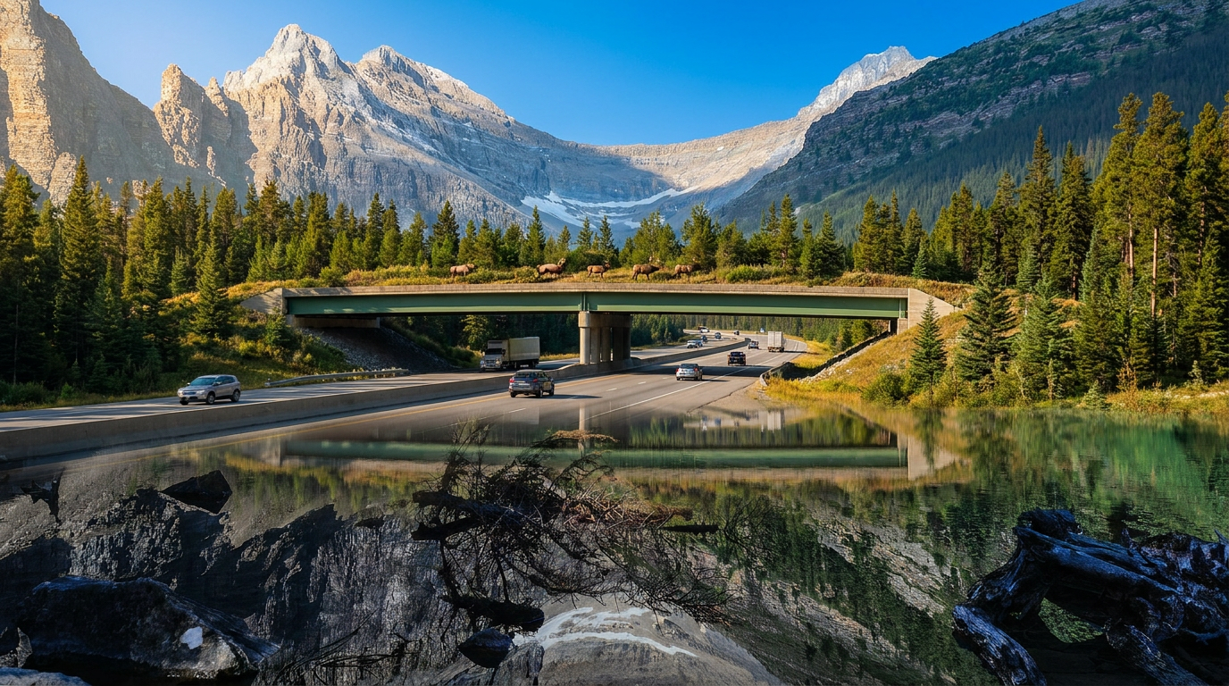
Today, that shift has materialized into one of the most ambitious and successful environmental movements on the continent: the construction of transboundary wildlife corridors. Driven by a coalition of scientists, Indigenous governments, and transportation officials, North America is quietly undergoing an infrastructure boom designed exclusively for animals. The goal is no longer just to conserve acreage, but to stitch a fragmented continent back together. This effort is anchored by the Yellowstone to Yukon (Y2Y) Conservation Initiative, a joint U.S.-Canada project that envisions a continuous, 2,100-mile ecological corridor stretching along the spine of the Rocky Mountains. By early 2026, the initiative and its partners celebrated a monumental milestone, completing more than 204 dedicated wildlife crossing structures across the region. These overpasses and underpasses, combined with targeted land acquisitions, are proving that human infrastructure and wild ecosystems can safely coexist.[2][3][6]
The mechanics of a wildlife corridor are surprisingly complex, requiring a deep understanding of animal psychology and behavior. A corridor is not simply a bridge thrown over a highway; it is a carefully engineered system that includes miles of funnel fencing designed to guide animals toward a safe crossing. Different species, and even different sexes within a species, have distinct architectural preferences. Elk and moose, which rely on wide lines of sight to spot predators, generally refuse to enter dark, enclosed spaces and will only use open-span overpasses. Conversely, male grizzly bears and cougars often prefer the stealth and cover of underpasses. Female grizzlies with cubs, however, are highly risk-averse and will almost exclusively choose overpasses to avoid being ambushed in a confined tunnel. By designing a matrix of diverse structures, engineers can accommodate the entire biological community of a given landscape.[3][6]
The results of this targeted engineering have been overwhelmingly positive, delivering benefits that extend far beyond ecological health. On highways where comprehensive crossing systems have been installed, collisions between vehicles and large hooved animals like deer, elk, and moose have plummeted by up to 96 percent. This represents a massive victory for public safety and economics, as wildlife-vehicle collisions cost North American taxpayers billions of dollars annually in medical expenses, property damage, and emergency response. The sheer effectiveness of these structures has transformed wildlife crossings from a niche environmental demand into a mainstream transportation priority. In regions like Montana and British Columbia, ranchers, tribal leaders, and policymakers who rarely align on political issues are now actively collaborating to secure funding for new overpasses, recognizing them as a rare win-win for human safety and animal welfare.[2][3]

While physical bridges solve the immediate danger of highway crossings, the broader challenge lies in mapping and protecting the invisible pathways animals use to navigate the continent. In early 2026, a groundbreaking study published in the journal FACETS provided the most detailed look yet at the continent's ecological arteries. A team of researchers from Canadian and U.S. institutions developed a high-resolution, binational map of ecological connectivity, seamlessly bridging the data gap across the longest terrestrial boundary in the world. Using a technique called circuit theory modeling, the scientists calculated the current density of the landscape—essentially mapping the probability of animal movement based on the natural resistance of different terrains and human developments. The resulting 300-meter resolution map highlights the critical pinch points and superhighways where wildlife movement is concentrated, particularly along the Rocky Mountains and the Great Lakes.[1][4]
In early 2026, a groundbreaking study published in the journal FACETS provided the most detailed look yet at the continent's ecological arteries.
The FACETS study revealed both the immense potential and the precarious state of North America's transboundary corridors. The researchers found that while existing protected areas capture many key migration routes, only about 19 percent of the highest-value connectivity hotspots fall within strictly protected government lands. When broader, multi-use conservation lands are included, that number rises to nearly 50 percent, but it still leaves half of the continent's most vital wildlife arteries vulnerable to development. The data underscores the critical role of private landowners and Indigenous territories in maintaining the continent's ecological fabric. Without the voluntary participation of ranchers placing conservation easements on their properties, or Indigenous nations managing vast tracts of intact wilderness, the bridges over the highways would simply lead animals into dead ends.[1][4][6]

The urgency of mapping and securing these corridors is accelerating due to the realities of climate change. As global temperatures rise, plant and animal species are being forced to migrate toward higher elevations and northern latitudes to stay within their survivable climate envelopes. If a species is trapped in an isolated park surrounded by impassable highways and urban sprawl, it cannot track the shifting climate and faces a high risk of localized extinction. Connectivity is the primary mechanism that allows ecosystems to adapt dynamically to a warming world. The 2026 transboundary mapping project provides policymakers with a literal roadmap for climate resilience, identifying exactly which parcels of land must remain permeable to allow the northward migration of biodiversity over the coming decades.[1][4]
The success of the Yellowstone to Yukon initiative offers a tangible blueprint for how this continental-scale connectivity can be achieved. Over the past three decades, the coalition has worked with willing private landowners to conserve more than 500,000 acres of critical valley-bottom habitat. These acquisitions are highly strategic, targeting the narrow geographic bottlenecks that link massive public parks. The impact on apex predators has been particularly striking. Historically, human development had fragmented grizzly bear populations into isolated genetic islands, putting them at risk of inbreeding and disease. Thanks to the restoration of key corridors, the geographic gap between isolated grizzly populations in the southern Rockies has shrunk from 150 miles to less than 45 miles today. Researchers are now finding grizzly footprints in restored transboundary corridors where the bears had been absent for decades.[2][3][5]

Despite these monumental biological wins, cross-border conservation remains highly vulnerable to political headwinds. Because nature management is divided between federal, state, provincial, and tribal jurisdictions, a policy shift in one capital can instantly sever a transboundary corridor. In recent years, fluctuating budgets and workforce reductions within U.S. federal land agencies have occasionally stalled joint mapping projects and delayed the implementation of critical habitat protections. When federal scientists are sidelined or funding for cross-border research is cut, local partners are left working from an incomplete picture of the landscape. Conservationists warn that achieving full connectivity requires sustained, rigorous investment that outlasts four-year political cycles, as the animals relying on these corridors operate on generational timelines.[5][6]
To insulate these vital pathways from political volatility, the conservation movement is increasingly looking toward Indigenous-led stewardship. Indigenous Protected and Conserved Areas (IPCAs) are emerging as the most effective mechanism for securing large-scale, unbroken landscapes. In northern British Columbia, near the Yukon border, the proposed Dene K’éh Kusān conservation area represents one of the largest tracts of intact, unprotected wilderness left in the region. Spanning nearly 10 million acres, it is considered the beating heart of the Yellowstone to Yukon corridor. By supporting the Kaska Dena and other Indigenous nations in their efforts to formally protect and manage these ancestral lands, conservationists are helping to anchor the northern reaches of the corridor with permanent, community-driven safeguards that are highly resilient to shifting federal policies.[2][6]

The push for transboundary connectivity is also reshaping international environmental diplomacy. Under the Kunming-Montreal Global Biodiversity Framework, nations have committed to the 30x30 target—protecting 30 percent of the planet's land and water by 2030. However, scientists are increasingly emphasizing that the raw acreage of protected land is meaningless if those areas are ecologically isolated. The new high-resolution connectivity maps prove that the quality of the connection is just as important as the quantity of the protection. As the United States and Canada work toward their respective 30x30 commitments, the focus is shifting from simply drawing borders around remote, ice-capped mountains to doing the hard, expensive work of securing the working landscapes and busy highway corridors that link them together.[1][4]
Ultimately, the story of North America's wildlife corridors is one of profound optimism. It proves that the environmental damage of the 20th century is not entirely permanent, and that human infrastructure can be retrofitted to accommodate the natural world. Every time a herd of elk safely navigates a forested overpass above a roaring interstate, it represents a triumph of science, engineering, and cross-cultural collaboration. The continent is slowly being stitched back together, one bridge, one underpass, and one conservation easement at a time. If the current momentum holds, the legacy of Pluie the wolf will not just be a cautionary tale of a fragmented landscape, but the foundational blueprint for the world's most resilient and interconnected mega-ecosystem.[3][5][6]
How we got here
1993
The Yellowstone to Yukon (Y2Y) Conservation Initiative is founded after the epic journey of Pluie the wolf highlights the need for connected landscapes.
2022
The Kunming-Montreal Global Biodiversity Framework establishes the 30x30 target, elevating the global importance of ecological connectivity.
Early 2026
The Y2Y initiative surpasses 204 completed wildlife crossing structures across the Rocky Mountain corridor.
March 2026
A groundbreaking study in FACETS publishes the first high-resolution, continuous map of transboundary wildlife connectivity between the U.S. and Canada.
Viewpoints in depth
Conservation Scientists
Focuses on genetic diversity, climate resilience, and the necessity of mapping ecological pinch points.
For ecologists and biologists, the primary value of wildlife corridors lies in genetic flow and climate adaptation. They argue that isolated populations inevitably suffer from inbreeding depression, making them highly susceptible to disease and environmental shocks. By utilizing advanced circuit theory modeling, scientists can pinpoint exactly which parcels of land act as the continent's biological arteries. They emphasize that as climate change forces species to migrate northward, maintaining these transboundary connections is the only viable strategy to prevent mass localized extinctions.
Indigenous Land Stewards
Prioritizes traditional ecological knowledge and the creation of large-scale Indigenous Protected and Conserved Areas.
Indigenous communities have long managed landscapes holistically, recognizing that artificial borders disrupt the natural movement of the animals they rely on for cultural and subsistence purposes. Indigenous leaders advocate for the establishment of Indigenous Protected and Conserved Areas (IPCAs), such as the proposed Dene K’éh Kusān in British Columbia. They argue that returning land stewardship to First Nations provides a more permanent, community-grounded form of conservation that is highly resilient to the shifting political winds of federal governments.
Transportation & Safety Officials
Views wildlife corridors primarily as highly effective infrastructure investments that save human lives and reduce economic costs.
From a civil engineering and public safety perspective, wildlife overpasses are a pragmatic solution to a deadly and expensive problem. Wildlife-vehicle collisions cost North American taxpayers billions of dollars annually in emergency response, medical bills, and property damage. Transportation officials point to the staggering 96 percent reduction in collisions at engineered crossing sites as proof that these structures pay for themselves over time. For this camp, funding a wildlife bridge is less about environmentalism and more about basic highway safety.
Private Landowners
Advocates for voluntary conservation easements that maintain working ranches while allowing wildlife passage.
Many critical wildlife corridors run directly through privately owned valley bottoms and agricultural lands. Ranchers and farmers in these areas often support conservation, provided it respects private property rights and economic livelihoods. This camp champions voluntary conservation easements, where landowners are financially compensated for agreeing not to subdivide or develop their land. They argue that working landscapes can successfully coexist with migrating wildlife, and that collaborative, incentive-based approaches are far more effective than heavy-handed federal mandates.
What we don't know
- How future federal budget cuts or political shifts in either the U.S. or Canada might impact long-term funding for cross-border corridor mapping.
- Whether the current pace of corridor construction is fast enough to keep up with the rapid climate-driven migration of species.
- Exactly how emerging zoonotic diseases will utilize these newly restored wildlife superhighways to spread across the continent.
Key terms
- Transboundary connectivity
- The degree to which landscapes across international or political borders allow for the unimpeded movement of wildlife and ecological processes.
- Circuit theory modeling
- A spatial ecology method that predicts animal movement by treating landscapes like electrical grids, where natural habitats conduct movement and human developments create resistance.
- Funnel fencing
- Specialized fencing installed along highways that physically blocks animals from the road and guides them toward safe overpasses or underpasses.
- 30x30 target
- A global conservation goal established under the UN Biodiversity Conference to protect 30 percent of the Earth's land and oceans by the year 2030.
- Conservation easement
- A voluntary legal agreement between a landowner and a land trust or government agency that permanently limits uses of the land to protect its conservation values.
Frequently asked
What is a wildlife corridor?
A wildlife corridor is a strip of natural habitat that connects populations of wildlife otherwise separated by human activities, such as highways or urban development.
Do animals actually use highway overpasses?
Yes, extensively. Studies show up to a 96 percent reduction in wildlife-vehicle collisions in areas where comprehensive crossing systems and funnel fencing are installed.
Why do different animals need different types of crossings?
Prey animals like elk prefer open overpasses to maintain a line of sight against predators, while predators like cougars and male grizzlies often prefer the cover of underpasses.
What is the Yellowstone to Yukon (Y2Y) initiative?
It is a joint U.S.-Canada project aiming to connect and protect a 2,100-mile ecological corridor along the Rocky Mountains, allowing wildlife to roam freely.
How does climate change affect the need for corridors?
As global temperatures rise, animals must migrate north or to higher elevations to survive. Corridors provide the essential pathways for this climate-driven adaptation.
Sources
Source coverage
6 outlets
4 viewpoints surfaced


[1]FACETS JournalConservation Scientists
Evaluating transboundary connectivity to support cross-border conservation between Canada and the United States
Read on FACETS Journal →[2]Yellowstone to Yukon Conservation InitiativeIndigenous Land Stewards
Y2Y 2025/2026 Impact Report: Reconnecting fragmented landscapes
Read on Yellowstone to Yukon Conservation Initiative →[3]Rewilding MagazinePrivate Landowners
Y2Y is making way for grizzlies and more
Read on Rewilding Magazine →[4]Conservation CorridorConservation Scientists
Evaluating transboundary connectivity to support cross-border conservation between Canada and the United States
Read on Conservation Corridor →[5]Corporate KnightsPrivate Landowners
The two countries have long shared responsibility for protecting endangered species
Read on Corporate Knights →[6]Factlen Editorial TeamTransportation & Safety Officials
Synthesis by Factlen editorial team
Read on Factlen Editorial Team →
Every angle. Every day.
Get world stories with full source coverage and perspective breakdowns delivered to your inbox.