How Aviation Technology is Mapping Invisible Turbulence to Keep Flights Safe
Airlines are replacing subjective radio reports with automated, real-time sensor networks to detect clear-air turbulence. This data-sharing revolution is saving millions in fuel while protecting passengers and crew from increasingly bumpy skies.
By Factlen Editorial Team
- Airline Operators
- Prioritize real-time data sharing and operational efficiency to reduce fuel burn and improve passenger comfort.
- Aviation Regulators
- Focus on standardizing safety protocols and funding advanced meteorological research to protect the flying public.
- Meteorological Researchers
- Emphasize the environmental drivers of turbulence, warning that climate change is actively altering the atmosphere.
What's not represented
- · Flight Attendants Unions
- · Nervous Flyers / Passenger Advocacy Groups
Why this matters
Turbulence is the leading cause of non-fatal injuries in commercial aviation and costs the industry up to $500 million annually. Understanding how pilots use real-time data to avoid rough air can significantly reduce flight anxiety and explain why seatbelt compliance remains crucial.
Key points
- Turbulence costs the U.S. airline industry up to $500 million annually in maintenance, fuel, and injuries.
- Climate change is increasing wind shear, driving a 55% rise in severe clear-air turbulence since 1979.
- Traditional weather radar cannot detect clear-air turbulence because it lacks moisture.
- Modern aircraft use onboard sensors to calculate the Eddy Dissipation Rate (EDR), an objective measure of rough air.
- The IATA Turbulence Aware platform crowdsources this sensor data, instantly sharing it with thousands of other aircraft.
- Predictive AI models are now combining live data with meteorological forecasts to route planes around turbulence hours in advance.
For millions of passengers, the sudden chime of the seatbelt sign and the subsequent jolting of the cabin is the most anxiety-inducing part of air travel. Turbulence feels chaotic and unpredictable, a visceral reminder that a 400-ton metal tube is suspended in a fluid atmosphere. Yet, behind the cockpit door, navigating rough air is no longer a matter of guesswork or white-knuckle flying. A quiet revolution in aviation technology has transformed turbulence from an invisible hazard into a mapped, quantifiable data set.[7]
The stakes for solving the turbulence problem are massive, both in human and financial terms. While modern commercial aircraft are engineered to withstand forces far beyond any naturally occurring turbulence, the bumps take a toll. The Federal Aviation Administration (FAA) estimates that turbulence costs the U.S. airline industry between $150 million and $500 million annually. These costs stem from aircraft wear-and-tear, mandatory post-flight maintenance inspections, increased fuel burn from inefficient rerouting, and medical care for injuries.[2]
When injuries do occur, they disproportionately affect the professionals working in the aisles. According to data from the National Transportation Safety Board (NTSB), there were 163 serious turbulence-related injuries on U.S. commercial airlines between 2009 and 2022. Of those, 129 were flight attendants, while only 34 were passengers. Because crew members spend the majority of the flight on their feet pushing heavy carts, they are highly vulnerable to sudden drops in altitude.[1][2]

The urgency to map rough air is accelerating because the atmosphere itself is changing. Researchers at the University of Reading recently found that climate change is actively altering the jet streams. Warmer air caused by carbon dioxide emissions increases wind shear—the difference in wind speed and direction over a short distance. This phenomenon has driven a 55% increase in the annual duration of severe clear-air turbulence over the North Atlantic between 1979 and 2020, with moderate turbulence rising by 37%.[1]
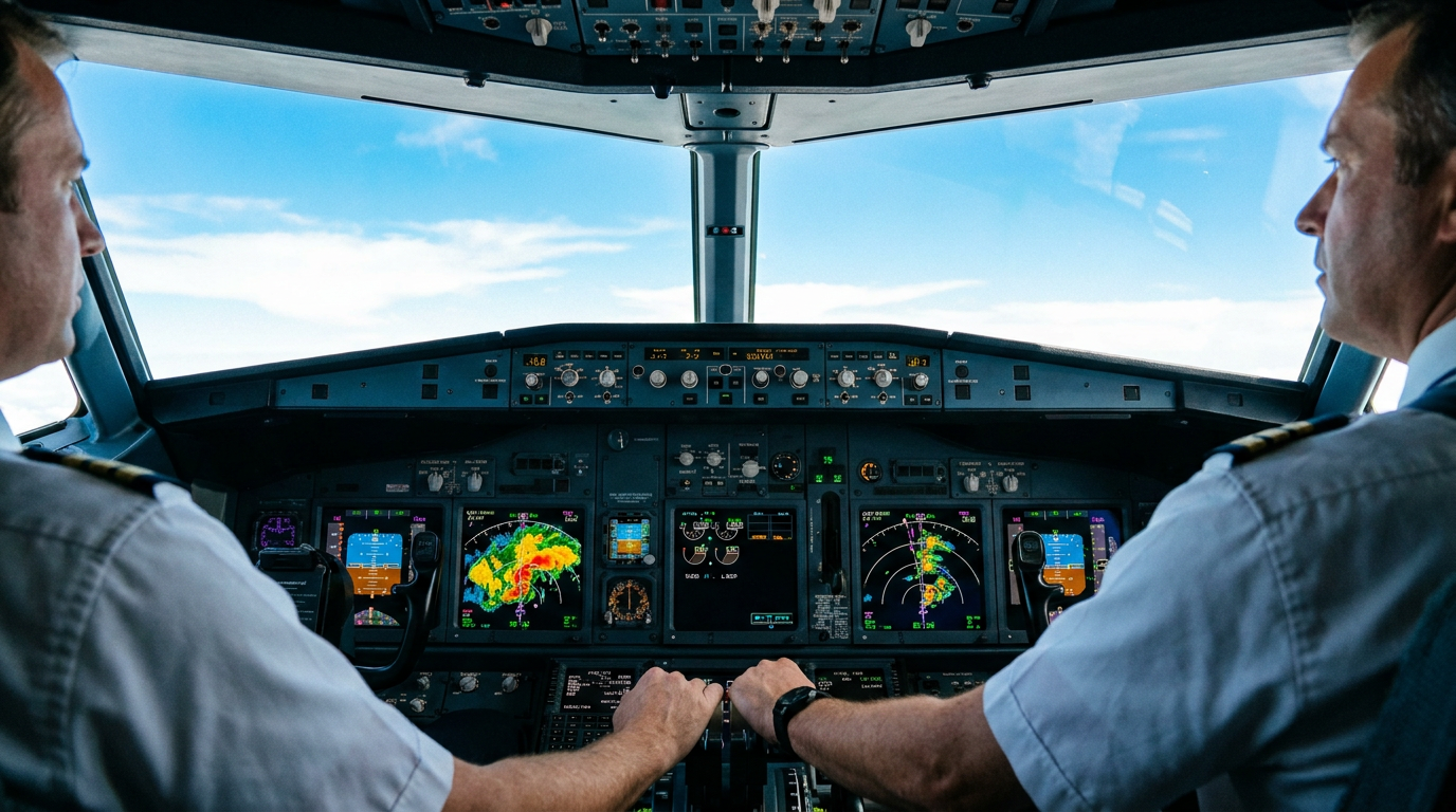
Historically, pilots relied on two primary tools to avoid these bumps: weather radar and the radio. Onboard weather radar is highly effective at detecting convective turbulence, which is generated by thunderstorms and rising warm air currents. Because radar works by bouncing radio waves off moisture—like rain or hail—it paints a clear picture of storm cells on the cockpit display, allowing pilots to steer around the red and yellow danger zones.[5]
However, radar has a glaring blind spot: it cannot see air. Clear Air Turbulence (CAT), the most dangerous and unpredictable form of rough air, contains no moisture. It occurs in cloudless skies, often near the edges of jet streams or over mountain ranges where fast-moving air crashes into atmospheric boundaries. Because CAT is invisible to radar, a plane can fly from perfectly smooth air into a severe jolt with zero warning on the dashboard.[5]

To combat invisible CAT, aviation relied for decades on PIREPs, or Pilot Weather Reports. When a plane hit rough air, the pilot would radio air traffic control to report the altitude and location. Controllers would then relay that warning to trailing aircraft. But PIREPs are inherently subjective. A jolt that feels like "moderate chop" to a pilot flying a massive Boeing 777 might feel like "severe turbulence" to a pilot in a smaller Embraer 175. Furthermore, radioing reports takes time, creating a lag between the encounter and the warning.[5]
To combat invisible CAT, aviation relied for decades on PIREPs, or Pilot Weather Reports.
The modern solution to this subjectivity is a metric called the Eddy Dissipation Rate (EDR). EDR removes human perception from the equation entirely. Instead of relying on a pilot's feeling, EDR uses the aircraft's own sensors—measuring airspeed, angle of attack, and vertical acceleration—to calculate the exact turbulent state of the atmosphere outside the plane. It provides a universal, objective number that describes exactly how rough the air is, regardless of the aircraft's size.[3][4]
EDR technology laid the groundwork for the International Air Transport Association (IATA) to launch the Turbulence Aware platform in 2018. Turbulence Aware acts as a global, real-time crowdsourcing network for commercial airliners. When an aircraft equipped with the software flies through turbulence, its sensors automatically calculate the EDR and beam that data down to ground servers without any input required from the flight crew.[4]
Once the ground servers receive the EDR data, the system instantly anonymizes it to protect airline privacy, performs quality control, and broadcasts it back up to every other participating aircraft in the network. This creates a live, continuously updating three-dimensional map of the atmosphere. A pilot flying over the mid-Atlantic can look at their tablet and see exactly what the air is doing 200 miles ahead, based on the automated telemetry of a plane that just passed through that exact airspace.[4]

The scale of the Turbulence Aware network has grown exponentially. As of early 2025, the platform ingests live data from 28 airlines operating more than 2,800 aircraft. In 2023 alone, the system generated 38 million automated turbulence reports. That data volume is expected to surge further as major global carriers, including Emirates, British Airways, and Singapore Airlines, integrate the software into their newest fleets, including the Airbus A350 and Boeing 777X.[4][6]
For pilots, this data is integrated directly into their electronic flight bags—the tablets they use to navigate. Applications like Lufthansa Systems' Lido mPilot overlay the EDR turbulence data directly onto the digital en-route maps. Instead of cross-referencing radio reports with paper charts, flight crews have a clear, color-coded visual of where the rough air sits, allowing them to request precise altitude changes from air traffic control before the seatbelt sign even needs to be illuminated.[6]
Beyond real-time reporting, the aviation industry is pushing toward predictive forecasting. The FAA, in partnership with the National Center for Atmospheric Research (NCAR), developed the Graphical Turbulence Guidance (GTG) system. The GTG acts as a "nowcast," combining live EDR reports with complex meteorological models to generate rapidly updating, 15-minute forecasts. This allows airline dispatchers on the ground to reroute flights tactically before they even take off.[2][3]
The integration of artificial intelligence is the next frontier for these forecasting models. By feeding decades of historical turbulence encounters and live EDR data into machine learning algorithms, meteorologists are beginning to predict how atmospheric boundaries will shift hours in advance. This predictive capability is crucial for long-haul flights, where the weather over the destination may change drastically during a 14-hour journey.[4]

The financial and environmental benefits of precise forecasting are nearly as significant as the safety improvements. When pilots lack accurate data, they are forced to fly defensively. They might take wide, inefficient detours around suspected turbulence zones, or fly at lower, less fuel-efficient altitudes to avoid a jet stream. By providing exact coordinates of smooth air, EDR networks allow airlines to optimize flight paths, saving millions of gallons of jet fuel and significantly reducing carbon emissions.[4][6]
Despite these technological leaps, aviation experts emphasize that the seatbelt remains the ultimate line of defense. Because the atmosphere is a dynamic fluid, micro-pockets of turbulence can still form spontaneously between reporting aircraft. The FAA and airlines universally advise passengers to keep their seatbelts fastened at all times while seated, even when the overhead sign is off.[2]
Ultimately, the modernization of turbulence forecasting represents a massive triumph of industry collaboration. By pooling data rather than hoarding it, airlines have transformed a terrifying natural phenomenon into a manageable operational variable. While climate change may be making the skies inherently bumpier, the invisible safety net of data sharing is ensuring that commercial aviation remains the safest way to travel.[7]
How we got here
1979–2020
Severe clear-air turbulence over the North Atlantic increases by 55% due to climate change.
2009–2022
The NTSB records 163 serious turbulence-related injuries on U.S. commercial flights.
2018
IATA launches the Turbulence Aware platform to crowdsource real-time atmospheric data.
2023
The Turbulence Aware network generates 38 million automated reports from participating aircraft.
2025
Major carriers like Emirates integrate live turbulence data directly into pilots' digital navigation tablets.
Viewpoints in depth
Aviation Regulators
Focus on standardizing safety protocols and funding advanced meteorological research to protect the flying public.
Agencies like the FAA and NTSB view turbulence primarily through the lens of injury prevention and structural safety. Their data consistently shows that flight attendants bear the brunt of turbulence-related injuries, prompting regulators to push for stricter in-cabin protocols and earlier seatbelt warnings. To support this, regulators invest heavily in partnerships with atmospheric research centers to develop predictive 'nowcasts' that give dispatchers the tools to reroute flights before they ever encounter dangerous airspace.
Meteorological Researchers
Emphasize the environmental drivers of turbulence, warning that climate change is actively altering the atmosphere.
Climate scientists and university researchers point to the data showing a clear, decades-long increase in Clear Air Turbulence (CAT). They argue that as carbon emissions warm the atmosphere, wind shear within the jet streams intensifies, creating more frequent and severe invisible eddies. For this camp, the aviation industry's technological adaptations are necessary band-aids, but they stress that the underlying atmospheric volatility will continue to worsen as global temperatures rise.
Airline Operators
Prioritize real-time data sharing and operational efficiency to reduce fuel burn and improve passenger comfort.
For commercial carriers and industry groups like IATA, turbulence is a massive operational friction that costs hundreds of millions of dollars in maintenance, delays, and excess fuel. Their solution is rooted in crowdsourced technology. By equipping fleets with automated sensors that broadcast the exact turbulent state of the air, airlines are shifting from reactive flying to proactive avoidance. This data-driven approach allows them to optimize flight paths, saving fuel and minimizing the wear-and-tear on their multi-million dollar aircraft.
What we don't know
- Exactly how much clear-air turbulence will increase globally as average temperatures continue to rise.
- Whether smaller regional airlines will be able to afford the integration of advanced EDR sensor networks.
- How quickly artificial intelligence can reliably predict micro-pockets of turbulence hours in advance.
Key terms
- Clear Air Turbulence (CAT)
- Invisible turbulent air caused by wind shear, typically near jet streams, which cannot be detected by traditional weather radar.
- Eddy Dissipation Rate (EDR)
- The universal, objective metric used by aviation systems to calculate the intensity of atmospheric turbulence based on aircraft sensor data.
- PIREP
- A pilot weather report transmitted by radio to air traffic control to warn trailing aircraft of conditions.
- Convective Turbulence
- Bumpy air caused by rising warm air currents, usually associated with thunderstorms and visible moisture.
- Wind Shear
- A sudden change in wind speed or direction over a short distance, which is the primary driver of clear-air turbulence.
Frequently asked
Can weather radar see all turbulence?
No. Radar detects moisture, making it effective for storm-related turbulence, but it cannot see Clear Air Turbulence, which occurs in cloudless skies.
Who is most at risk of injury during turbulence?
Flight attendants. According to NTSB data, crew members account for nearly 80% of serious turbulence injuries because they are often standing to perform their duties.
Is climate change making turbulence worse?
Yes. Warmer air increases wind shear in the jet streams, which has driven a 55% increase in severe clear-air turbulence over the North Atlantic since 1979.
How do planes share turbulence data?
Modern aircraft automatically calculate the turbulence intensity using onboard sensors and beam the data to ground servers, which instantly broadcast it to other planes.
Sources
Source coverage
7 outlets
3 viewpoints surfaced


[1]ForbesMeteorological Researchers
Climate Change Is Making The Worst Turbulence More Common
Read on Forbes →[2]FAAAviation Regulators
Turbulence Safety & Statistics
Read on FAA →[3]UCAR/NCARAviation Regulators
Turbulence Nowcast and Eddy Dissipation Rate
Read on UCAR/NCAR →[4]IATAAirline Operators
Turbulence Aware Platform
Read on IATA →[5]HowStuffWorksMeteorological Researchers
How Airlines Predict Turbulence
Read on HowStuffWorks →[6]EmiratesAirline Operators
Emirates joins IATA Turbulence Aware
Read on Emirates →[7]Factlen Editorial TeamAirline Operators
Synthesis by Factlen editorial team
Read on Factlen Editorial Team →


Every angle. Every day.
Get travel stories with full source coverage and perspective breakdowns delivered to your inbox.