How AI and Drone Swarms Are Solving the Global Landmine Crisis
The integration of machine learning and multi-sensor drones is revolutionizing humanitarian demining, turning a process that once took centuries into a rapid, automated science.
By Factlen Editorial Team
- Humanitarian Deminers
- Focuses on the immediate need to return safe land to civilians while maintaining strict safety protocols.
- Defense Technologists
- Views the crisis as a data and engineering challenge that can be solved through rapid iteration and sensor fusion.
- AI Safety Researchers
- Cautions against over-reliance on algorithms, emphasizing the deadly consequences of false negatives.
What's not represented
- · Local farmers awaiting land clearance
- · Environmental scientists studying soil toxicity
Why this matters
Landmines kill or maim thousands of civilians annually and render millions of acres of prime agricultural land unusable for generations. The successful application of AI to this problem is accelerating clearance efforts by decades, directly saving lives and restoring local economies.
Key points
- Ukraine is currently the most heavily mined country, with traditional clearance estimated to take over 700 years.
- Drones equipped with AI and multi-sensor payloads can survey up to 10,000 square meters of hazardous area per day.
- Machine learning models have achieved over 90% accuracy in detecting surface-scattered plastic mines in controlled trials.
- Ground robotics and VR-controlled excavators are being deployed to physically remove explosives without risking human lives.
- The technology serves primarily as an area-reduction tool, as AI cannot yet guarantee the 100% reliability required for final clearance.
The global landmine crisis represents one of the most enduring and lethal legacies of modern conflict. Following recent escalations, Ukraine has become the most heavily mined country in the world, with an estimated 23% to 30% of its territory contaminated by unexploded ordnance. For decades, the standard protocol for humanitarian demining has relied on the geophysical principles of electromagnetic induction. Sappers slowly crawl through fields with handheld metal detectors, physically prodding the soil—a process that is painstakingly slow, highly dangerous, and prone to false positives from harmless metallic debris.[1][3][6]
The sheer scale of the contamination has rendered traditional methods mathematically unfeasible. Using conventional tools, experts estimate it would take 757 years and cost over $37 billion to fully demine Ukraine alone. Globally, the crisis is even more staggering, with an estimated 5 billion square meters of land remaining contaminated, affecting the daily lives and economic prospects of 100 million people. The disconnect between the rapid deployment of modern scatterable munitions and the archaic toolkit used to remove them has forced a technological reckoning.[1][2][3]
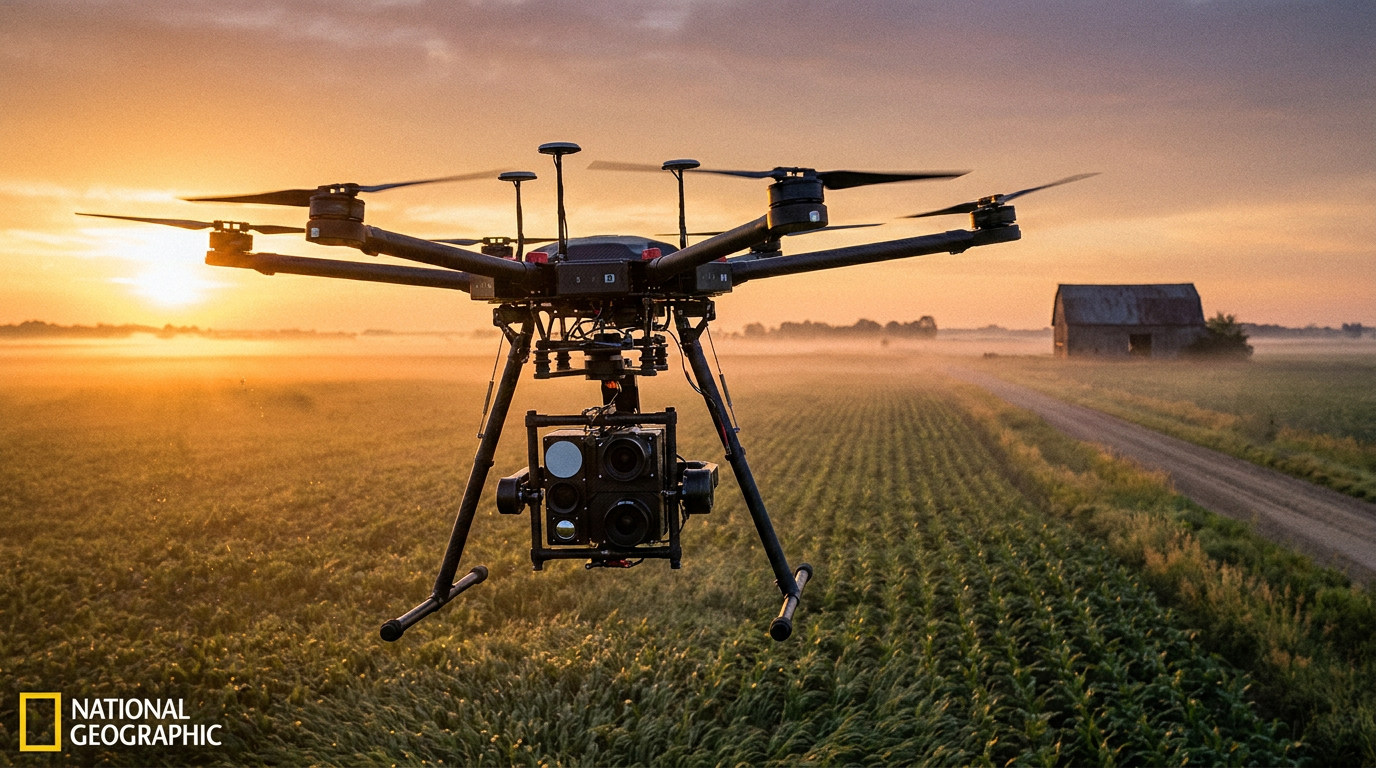
A paradigm shift is now underway, driven by the integration of unmanned aerial vehicles (UAVs) and advanced computer vision foundation models. By replacing human sappers with multi-sensor drone swarms, clearance organizations are transitioning from physical search to automated remote sensing. This approach fundamentally alters the timeline of post-conflict recovery, turning a generational burden into a rapid, data-driven science.[7]
The primary claim supporting this shift is the exponential increase in survey speed. Drones equipped with high-resolution cameras can survey up to 10,000 square meters of suspected hazardous areas in a single day. Organizations like The HALO Trust have already utilized these digital workflows to create a common operating picture, clearing over 36,000 explosives and returning 20 million square meters of farmland to civilian use faster than previously thought possible.[2]

The core technological breakthrough lies in the ability of machine learning models to accurately identify surface-scattered mines. Scatterable plastic mines, such as the PFM-1, are notoriously difficult to detect with traditional metal detectors because they utilize liquid explosives encapsulated in polyethylene bodies, containing almost no metallic components. These small, soda-can-sized munitions are often deployed randomly over wide areas, making manual clearance exceptionally hazardous.[3][4]
Primary research validates the efficacy of AI in solving this specific problem. In a proof-of-concept study published in The Journal of Conventional Weapons Destruction, researchers deployed a Faster Region-based Convolutional Neural Network (Faster R-CNN) to analyze multispectral drone imagery. In controlled trials, the algorithm achieved a 91.8% accuracy rate in detecting PFM-1 anti-personnel mines from visual RGB data, proving that neural networks can successfully automate the classification process.[3]
Further academic evaluation reinforces these findings across different AI architectures. Recent studies testing computer vision foundation models on custom drone flyby datasets have demonstrated high mean Average Precision (mAP) scores. Researchers achieved a mAP of 0.89 using the YOLOF model for drone images taken from 10 meters above ground level. This evidence confirms that off-the-shelf object detection models, traditionally used for ground video surveillance, can be effectively fine-tuned for aerial ordnance detection.[4]

Further academic evaluation reinforces these findings across different AI architectures.
However, visual detection has inherent limitations. RGB cameras fail when mines are obscured by dense vegetation, buried under soil, or deployed in low-light conditions. To counter this vulnerability, engineers are layering multiple data streams, a process known as sensor fusion, to ensure threats are not missed by a single point of failure.[7]
The evidence for subsurface and obscured detection relies heavily on thermal and radar technologies. Drones are now routinely equipped with thermal infrared sensors, which detect the differential heat signatures between explosive casings and the surrounding soil as temperatures change throughout the day. Additionally, Ground Penetrating Radar (GPR) is being integrated into aerial platforms to provide non-contact subsurface imaging, identifying hidden cavities and buried munitions by analyzing reflected radar pulses.[3][4][7]
Despite these advancements, transparent uncertainty remains regarding the real-world reliability of these systems. While laboratory and controlled-field metrics are highly promising, the mine action community remains cautious because false negatives are fatal. An AI model that is 99% accurate still leaves behind lethal threats, meaning the technology currently serves as an area reduction tool—identifying definitively safe zones—rather than a complete replacement for final clearance verification.[2][3][7]
Specific weaknesses in the current AI models stem from environmental noise. Algorithms trained on pristine datasets often struggle with battlefield debris, such as metal shavings, shrapnel, and natural obstacles like thick brush. Furthermore, thermal imaging is highly dependent on diurnal cycles, requiring flights at specific times of day to capture optimal temperature contrasts. The AI must be trained on massive, diverse datasets to minimize these edge cases.[1][4]
To bridge the gap between aerial detection and physical neutralization, engineers are deploying advanced ground robotics. Once a drone swarm maps a high-risk zone and the AI color-codes the threat levels, unmanned ground vehicles (UGVs) are sent in to safely detonate or extract the explosives, keeping human operators entirely out of the blast radius.[1][7]

The evidence for robotic clearance is materializing on active frontlines. Emergency services have deployed advanced robotic dogs capable of navigating complex urban terrain—such as stairs and thick grass—to approach explosives remotely. These mechanical canines transmit high-resolution video back to sappers, allowing them to assess the threat without stepping into the hazard zone.[6]
To further distance humans from danger, operators are integrating Virtual Reality (VR) into the clearance process. From inside reinforced steel cages located far from the minefield, deminers wear VR headsets to control unmanned excavators. These remote-controlled machines dig through contaminated soil and feed it into specialized grinders designed to safely destroy hidden explosives, completely eliminating direct human exposure.[5]

The long-term humanitarian impact of this technological acceleration extends far beyond Eastern Europe. The HALO Trust and other organizations operate in dozens of countries, and the digital workflows, AI models, and robotic platforms proven in Ukrainian fields are already being adapted for legacy minefields in regions like Cambodia, Angola, and Syria.[2]
The shift from manual probing to AI-driven remote sensing represents one of the most significant advancements in humanitarian aid in decades. While the technology requires continuous refinement to eliminate the deadly risk of false negatives, the trajectory is clear: machines are absorbing the physical risk, allowing human communities to safely reclaim their land, rebuild their economies, and restore their futures.[7]
How we got here
Pre-2022
Humanitarian demining relies almost entirely on manual prodding and handheld metal detectors.
2023
The scale of contamination in Ukraine prompts a massive influx of tech startups into the demining sector.
2024
Researchers successfully prove that convolutional neural networks can identify surface mines from drone imagery with over 90% accuracy.
2025
Major NGOs like The HALO Trust integrate AI mapping and digital workflows, clearing tens of thousands of explosives.
2026
Fully autonomous ground robots and VR-controlled excavators begin frontline deployment to physically remove mapped threats.
Viewpoints in depth
Humanitarian Deminers
Focuses on the immediate need to return safe land to civilians while maintaining strict safety protocols.
For organizations like The HALO Trust, technology is a means to an end: restoring agricultural and residential land. They view AI not as a replacement for human expertise, but as a triage tool. By using drones to quickly rule out empty fields (area reduction), they can concentrate their highly trained human sappers on confirmed hazardous zones, drastically reducing the time it takes to declare a region safe.
Defense Technologists
Views the crisis as a data and engineering challenge that can be solved through rapid iteration.
Startups and engineers treat minefields as complex datasets. They argue that by fusing multiple sensor streams—RGB, thermal, and radar—and feeding them into increasingly sophisticated neural networks, the detection process can eventually become fully autonomous. Their goal is to remove humans from the blast radius entirely, relying on expendable drone swarms and robotic dogs.
AI Safety Researchers
Cautions against over-reliance on algorithms in life-or-death scenarios.
Academics and safety experts highlight the 'false negative' problem. While an AI model might achieve 99% accuracy in a lab, real-world variables like weather, vegetation growth, and battlefield debris introduce unpredictable noise. They argue that until an AI can guarantee 100% detection, human verification remains legally and morally mandatory.
What we don't know
- Whether AI models trained on specific mine types in Eastern Europe will generalize effectively to legacy minefields in Southeast Asia or Africa.
- How quickly regulatory bodies will approve fully autonomous robotic clearance without human verification.
- The long-term environmental impact of leaving neutralized, degraded explosive chemical casings in agricultural soil.
Key terms
- Unexploded Ordnance (UXO)
- Explosive weapons that failed to detonate when fired or dropped and still pose a lethal risk.
- Ground Penetrating Radar (GPR)
- A geophysical method that uses radar pulses to image the subsurface and detect buried objects.
- Faster R-CNN
- A machine learning model architecture highly effective at detecting and drawing bounding boxes around specific objects in images.
- Area Reduction
- The process of confidently identifying land that does not contain explosives, allowing deminers to focus only on actual threat zones.
Frequently asked
Can AI completely replace human deminers?
Not yet. AI and drones are currently used for 'area reduction'—identifying safe zones and mapping threats—but physical extraction still requires human oversight or ground robots.
How does the AI find buried mines?
Drones use a combination of thermal imaging to detect heat differentials in the soil and Ground Penetrating Radar (GPR) to identify subsurface cavities and metallic signatures.
What happens when a mine is found?
Once mapped, unmanned ground vehicles or remote-controlled excavators are deployed to safely detonate or remove the explosive without risking human lives.
Sources
Source coverage
7 outlets
3 viewpoints surfaced


[1]ForbesDefense Technologists
Inside The Race To Clear Ukraine's Minefields With Robots And AI
Read on Forbes →[2]Geo Week NewsHumanitarian Deminers
How Drones and AI Are Helping Clear 36,000 Landmines in Ukraine
Read on Geo Week News →[3]The Journal of Conventional Weapons DestructionAI Safety Researchers
How to Implement Drones and Machine Learning to Reduce Time, Costs, and Dangers Associated with Landmine Detection
Read on The Journal of Conventional Weapons Destruction →[4]arXivAI Safety Researchers
Comparing Surface Landmine Object Detection Models on a New Drone Flyby Dataset
Read on arXiv →[5]WIONHumanitarian Deminers
AI And VR Technology Are Helping Clear Ukraine's Minefields
Read on WION →[6]TVP WorldDefense Technologists
Robotic dog helps remove landmines in Ukraine
Read on TVP World →[7]Factlen Editorial TeamHumanitarian Deminers
Synthesis by Factlen editorial team
Read on Factlen Editorial Team →
Every angle. Every day.
Get defense security stories with full source coverage and perspective breakdowns delivered to your inbox.