How AI and Drone Swarms Are Revolutionizing Humanitarian Demining
The integration of artificial intelligence, thermal imaging, and magnetic sensors into commercial drones is allowing clearance teams to map unexploded ordnance from the air, drastically accelerating the recovery of post-conflict zones.
By Factlen Editorial Team
- Defense & Engineering Researchers
- Focused on the technical breakthroughs in sensor fusion and machine learning accuracy.
- Humanitarian Demining NGOs
- Focused on clearing post-conflict zones to save civilian lives and reclaim agricultural land.
- Military Modernization Planners
- Focused on integrating unmanned systems into combat engineering to keep soldiers out of minefields.
- Independent Analysts
- Focused on synthesizing the broader impact of dual-use technologies on global security.
What's not represented
- · Local civilian populations living in heavily mined agricultural regions.
- · Manual demining technicians whose daily operational protocols are being disrupted.
Why this matters
Manual demining is a slow, deadly process that leaves millions of acres of agricultural land unusable for decades. By shifting the search for explosives from the ground to the air, this technology promises to save thousands of lives and rapidly restore economic stability to post-conflict regions.
Key points
- More than 100 million landmines and unexploded ordnance devices remain hidden in conflict zones globally.
- Traditional manual demining is slow and dangerous, resulting in three worker casualties for every 5,000 mines cleared.
- Drone-mounted thermal cameras and AI have demonstrated a 90 percent accuracy rate in detecting surface and shallow-buried mines.
- Magnetic imaging systems can detect deeply buried artillery shells up to 3 meters underground, even beneath water and silt.
- While AI excels at mapping hazard zones, human experts and specialized robots are still required to neutralize the explosives.
More than 100 million landmines and unexploded ordnance (UXO) devices remain hidden in present and former conflict zones worldwide, killing or maiming thousands of civilians annually. For decades, humanitarian agencies have relied on manual clearance methods—sweeping the ground with metal detectors and probing the dirt by hand. This process is agonizingly slow, highly expensive, and inherently treacherous. According to the United Nations, for every 5,000 mines recovered, three workers are injured or killed.[2]
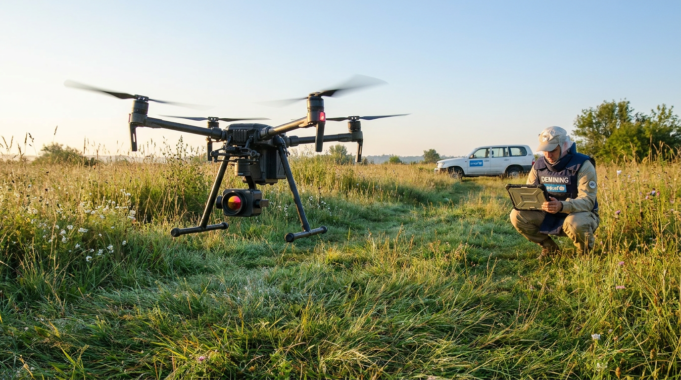
A major technological shift is now underway, driven by the urgent need to clear vast contaminated areas in post-conflict regions. The integration of commercial drones, artificial intelligence, and advanced sensor fusion is transforming demining from a manual, ground-level crawl into a rapid, aerial data-gathering operation. By removing humans from the immediate danger zone, these systems promise to drastically accelerate the pace of humanitarian recovery.[1][3][7][8]
Claim 1: Thermal imaging combined with machine learning can identify surface and shallow-buried mines faster and more accurately than human teams. Evidence from researchers at Columbia University and Binghamton University demonstrates that drone-mounted thermal cameras can detect specific explosive devices with remarkable precision. The system works by sensing minute temperature differences between the explosive casing and the surrounding soil and vegetation.[2][8]
In peer-reviewed field tests, this airborne system was trained to spot the widely deployed PFM-1 antipersonnel mine. The AI-driven thermal mapping performed significantly faster than traditional human sweeps and achieved a 90 percent detection accuracy. The primary advantage lies in mapping the hazard zones before any personnel step foot into the minefield, allowing clearance teams to prioritize their efforts safely.[2]

Claim 2: Multi-sensor platforms can detect deeply buried ordnance, even underwater or beneath thick sediment. While thermal imaging excels at surface-level detection, finding deeply buried artillery shells requires different physics. In Ukraine, the Postup Foundation recently tested its MinesEye platform—a heavily modified agricultural drone equipped with high-resolution magnetic imaging.[3][8]
During real-world trials over a lake in the Kyiv region, the drone flew just 20 centimeters above the water's surface, scanning for explosive remnants buried under layers of silt. The system successfully detected ferromagnetic anomalies, identifying mines at depths of up to 0.5 meters and larger artillery shells up to 3 meters underground. This project, which received R&D funding from NATO, highlights the efficacy of combining precision farming algorithms with military-grade magnetic sensors.[3]
The system successfully detected ferromagnetic anomalies, identifying mines at depths of up to 0.5 meters and larger artillery shells up to 3 meters underground.
Claim 3: Crowdsourced data and hackathons are rapidly maturing the AI models required for accurate detection. The primary bottleneck for AI in demining is not the hardware, but the software's ability to distinguish a live explosive from harmless scrap metal. To solve this, organizations are compiling massive, open-source datasets of battlefield imagery to train more resilient algorithms.[1][7][8]
In July 2025, the United Nations Development Programme (UNDP) and the Government of Luxembourg sponsored an AI Data Jam in Kyiv. Dozens of data analysts processed approximately 30,000 field images containing soil, metal, and vegetation, training machine learning models to identify explosive hazards amidst environmental noise. The winning model, developed by a team called Mine Watch AI, proved highly accurate and received funding for further integration with humanitarian demining experts.[1]

Claim 4: Military investments in autonomous combat engineering are accelerating the underlying technology. While humanitarian NGOs focus on post-conflict clearance, active militaries are heavily funding unmanned systems for route clearance under fire. The Center for Strategic and International Studies notes that the defense industry has pioneered the use of small AI models integrated into uncrewed ground vehicles (UGVs) and drones for multidomain assaults and mine clearance.[5][6][8]
Similarly, in February 2026, the South Korean Army conducted the first live operational training of its unmanned Korean Combat Engineering Vehicle (K-CEV). The platform integrates reconnaissance drones, an AI-based battlefield awareness system, and an explosive ordnance disposal robot equipped with 3D ground-penetrating radar. These military R&D budgets are effectively subsidizing the sensor and software advancements that will eventually trickle down to humanitarian applications.[5][8]
Claim 5: Advanced human-machine interfaces are making remote analysis more intuitive for operators. As drones collect vast amounts of sensor data, presenting that information clearly to technicians is critical. A March 2026 paper presented at the IEEE International Conference on Mechatronics, Control and Robotics detailed a bespoke unmanned aerial system that pairs a magnetometer sensor suite with a virtual reality (VR) interface.[4][8]
This VR-enabled interface allows operators to visualize the magnetic anomalies in a three-dimensional space, providing a safe, flexible, and cost-effective alternative to staring at raw data feeds. The researchers concluded that this intelligent automated technique holds strong potential for scaling humanitarian demining operations globally by reducing the cognitive load on analysts.[4]

Uncertainty and Limitations: The technology is not yet a standalone solution. Despite the rapid progress, AI-powered drones cannot yet replace human Explosive Ordnance Disposal (EOD) technicians entirely. The systems still struggle with false positives in highly contaminated urban environments, where rebar, shrapnel, and civilian debris confuse the algorithms. Furthermore, thermal imaging is highly dependent on the time of day and weather conditions, and dense jungle canopies can block aerial sensors entirely.[1][2][7][8]
Ultimately, the current generation of AI drones serves as an advanced eye in the sky, mapping the danger so that specialized robots or human experts can perform the physical neutralization. By shifting the most dangerous phase of demining—the search—from the ground to the air, this technology is poised to save thousands of lives and reclaim millions of acres of land for safe civilian use.[7][8]
How we got here
2022-2024
The widespread use of landmines in global conflicts prompts a surge in R&D for remote, unmanned demining technologies.
July 2025
The UNDP hosts the AI Data Jam in Kyiv, training new machine learning models on 30,000 field images of explosive hazards.
February 2026
The South Korean Army conducts the first live operational training of its unmanned combat engineering vehicle, integrating AI drones and 3D radar.
March 2026
Researchers present new virtual reality interfaces for drone-based magnetometer demining at the IEEE robotics conference in Tokyo.
Viewpoints in depth
Humanitarian Demining NGOs
Focused on clearing post-conflict zones to save civilian lives and reclaim agricultural land.
This camp emphasizes the urgent need to replace slow, dangerous manual probing with scalable aerial technology. Organizations like the UNDP and the HALO Trust argue that crowdsourcing AI training data and funding open-source detection models are the fastest ways to reduce the casualty rate among clearance workers and return land to local communities.
Defense & Engineering Researchers
Focused on the technical breakthroughs in sensor fusion and machine learning accuracy.
Academic and defense researchers highlight the physics and algorithmic challenges of UXO detection. They point to peer-reviewed evidence showing that combining thermal imaging, LiDAR, and magnetometers can achieve 90 percent accuracy. However, they caution that dense vegetation, highly mineralized soils, and urban debris still pose significant hurdles that require further algorithmic refinement.
Military Modernization Planners
Focused on integrating unmanned systems into combat engineering to keep soldiers out of minefields.
Military strategists view AI demining through the lens of force protection and multidomain operations. By deploying autonomous combat engineering vehicles equipped with drone swarms and 3D ground-penetrating radar, armed forces aim to conduct rapid route clearance under fire, effectively subsidizing the R&D that eventually benefits humanitarian efforts.
What we don't know
- How reliably thermal and magnetic sensors perform under dense jungle canopies or in highly mineralized soils.
- The exact timeline for scaling these prototype drone platforms to fully replace manual demining teams globally.
- Whether autonomous systems can consistently distinguish between deeply buried UXO and harmless urban debris without high false-positive rates.
Key terms
- Unexploded Ordnance (UXO)
- Explosive weapons, such as bombs, shells, or landmines, that did not explode when they were deployed and still pose a risk.
- Sensor Fusion
- The process of combining data from multiple different sensors, like thermal cameras and magnetometers, to create a more accurate understanding of the environment.
- LiDAR
- A remote sensing method that uses pulsed lasers to measure variable distances and create highly precise 3D maps of terrain.
- Magnetometer
- An instrument that measures the strength and direction of magnetic fields, used to detect buried metallic objects.
Frequently asked
How do drones detect buried landmines?
Drones use a combination of thermal imaging to detect heat differences in the soil, magnetometers to find metallic casings, and LiDAR to map surface anomalies.
Can AI replace human deminers completely?
Not yet. AI and drones are currently used to map hazard zones and identify anomalies, but human experts or specialized robots are still required to safely neutralize the explosives.
How accurate is AI at finding unexploded ordnance?
Recent field tests show AI models can achieve up to 90% accuracy in detecting certain types of mines, though dense vegetation and scrap metal can still cause false positives.
How deep can these sensors detect explosives?
Advanced magnetic imaging systems mounted on drones have successfully detected smaller mines at depths of 0.5 meters and larger artillery shells up to 3 meters underground.
Sources
Source coverage
8 outlets
4 viewpoints surfaced


[1]United Nations Development ProgrammeHumanitarian Demining NGOs
AI Data Jam hackathon in Kyiv develops models to detect explosive hazards
Read on United Nations Development Programme →[2]Columbia UniversityDefense & Engineering Researchers
Using Drones and Artificial Intelligence to Find Land Mines
Read on Columbia University →[3]The DefenderHumanitarian Demining NGOs
Ukrainian developers test MinesEye remote demining platform with AI
Read on The Defender →[4]IEEEDefense & Engineering Researchers
Development of a Small-Scale UAS for Rapid UXO Detection Using Magnetometers and VR
Read on IEEE →[5]Army RecognitionMilitary Modernization Planners
South Korean Army tests K-CEV optionally unmanned engineering vehicle with AI and drones
Read on Army Recognition →[6]Center for Strategic and International StudiesDefense & Engineering Researchers
Ukraine’s Innovative Approach to Unmanned Systems and AI
Read on Center for Strategic and International Studies →[7]Security Pro USAMilitary Modernization Planners
The Future of UXO Detection: How Drones, Robots, and AI Are Saving Lives
Read on Security Pro USA →[8]Factlen Editorial TeamIndependent Analysts
Synthesis by Factlen editorial team
Read on Factlen Editorial Team →
Every angle. Every day.
Get defense security stories with full source coverage and perspective breakdowns delivered to your inbox.