AI-Powered Drone Swarms Are Revolutionizing Humanitarian Demining
By combining multi-modal sensors with deep learning algorithms, researchers and defense startups are automating landmine detection, achieving over 90% accuracy and drastically reducing the risk to human sappers.
By Factlen Editorial Team
- Defense Tech Innovators
- Focus on rapidly scaling the technology, improving algorithmic accuracy, and integrating aerial mapping with ground robotics.
- Humanitarian NGOs
- Prioritize the safety of demining personnel and advocate for free, open-source access to life-saving AI technology.
- Academic Researchers
- Emphasize rigorous peer-reviewed testing, sensor fusion, and solving specific material challenges like thermal detection of plastic.
What's not represented
- · Local agricultural communities waiting to reclaim their land
- · Government regulatory bodies overseeing drone airspace in post-conflict zones
Why this matters
Traditional demining is a slow, lethal process that leaves post-conflict zones uninhabitable for decades. By removing humans from the initial detection phase, AI and drone technology can accelerate land reclamation exponentially, saving thousands of civilian and sapper lives.
Key points
- An estimated 110 million landmines contaminate 60 countries, with Ukraine currently the most heavily mined nation.
- Traditional manual demining is slow and dangerous, resulting in three sapper casualties for every 5,000 mines cleared.
- Drones equipped with thermal, magnetic, and radar sensors can survey up to 10,000 square meters of land per day.
- Deep learning algorithms have achieved over 91% accuracy in identifying hidden ordnance, including hard-to-detect plastic mines.
- Humanitarian organizations are partnering with tech startups to deploy these AI models, often prioritizing free access for NGOs.
The global landmine crisis represents one of the most enduring and lethal legacies of modern warfare. Across roughly 60 countries, an estimated 110 million landmines remain hidden beneath the soil, rendering vast tracts of agricultural land unusable and claiming thousands of civilian lives annually. In Ukraine alone, which currently stands as the most heavily mined country in the world, approximately 170,000 square kilometers—an area roughly half the size of Germany—is contaminated with explosive ordnance. Clearing this immense hazard using traditional methods is a daunting prospect; analysts estimate that relying solely on manual sappers would take over 750 years and cost tens of billions of dollars.[1][2][4][5]
For decades, the standard protocol for humanitarian demining has remained tragically archaic and dangerous. Human technicians must slowly sweep the ground with metal detectors, painstakingly probing the dirt for anomalies. This process inevitably churns up harmless debris like nails and spent bullet casings, leading to a high rate of false positives that drastically slows progress. More critically, the human cost is severe: the United Nations reports that for every 5,000 mines successfully recovered, three demining workers are injured or killed.[5]
However, a breakthrough convergence of commercial drone technology, multi-modal sensors, and deep learning algorithms is fundamentally rewriting the timeline and safety protocols for landmine clearance. By deploying unpiloted aerial systems (UAS) equipped with advanced imaging payloads, researchers and defense startups are shifting the most dangerous phase of demining—the initial survey and detection—into the sky, removing humans from the blast radius entirely.[1][2][4]
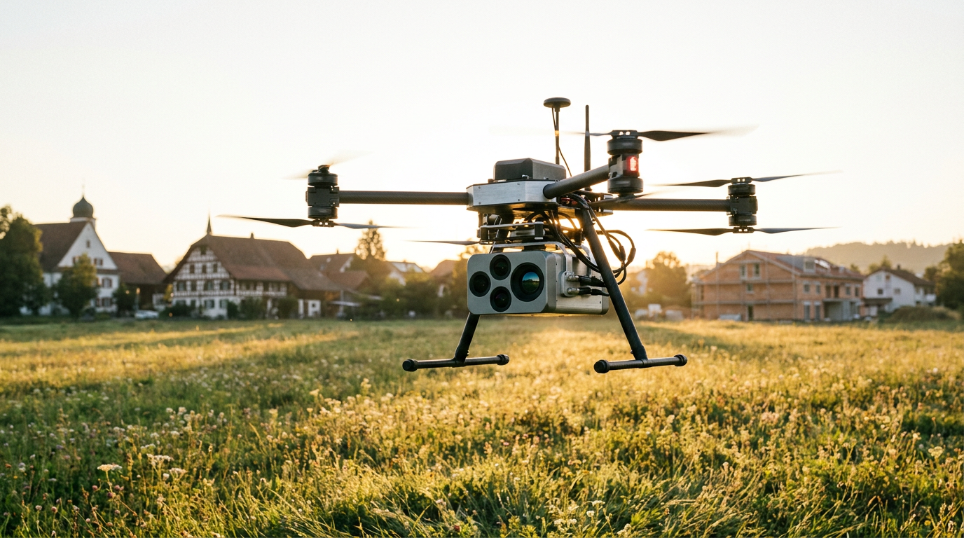
The technological mechanism relies on low-altitude drone flights, typically operating just 10 to 20 meters above the ground to maximize sensor resolution. These drones carry a sophisticated array of instruments, including high-resolution RGB cameras, infrared thermography sensors, magnetometers, and increasingly, Ground Penetrating Radar (GPR). As the drone sweeps a suspected hazardous area, it non-destructively images the subsurface, transmitting radar pulses into the soil to detect hidden cavities, communications, and explosive devices.[3][6][8]

Hardware alone, however, generates an overwhelming volume of data. The true paradigm shift lies in the application of artificial intelligence to process this multi-sensor telemetry. Engineering teams are utilizing region-based convolutional neural networks (R-CNN) and object-detection algorithms like YOLO (You Only Look Once) to instantly analyze the imagery. By training these models on hundreds of thousands of labeled images of inert mines and 3D-printed replicas under various lighting and environmental conditions, the AI learns to automatically identify the distinct visual and thermal signatures of buried ordnance.[6][7]
This AI-driven approach has proven particularly vital for detecting modern plastic landmines, which are explicitly designed to evade traditional metal detectors. The Soviet-era PFM-1 "butterfly" mine, a scatterable munition widely deployed in recent conflicts, is notoriously difficult to locate. Because it is largely composed of plastic and is roughly the size of a cell phone, geophysical techniques like electromagnetic induction often fail to register it. Researchers from Binghamton University and Columbia University targeted this specific vulnerability, designing an airborne system that senses minute temperature differences between the plastic mine and the surrounding soil.[5][6]
This AI-driven approach has proven particularly vital for detecting modern plastic landmines, which are explicitly designed to evade traditional metal detectors.
The empirical results from these academic trials demonstrate a massive leap in efficacy. In peer-reviewed studies published in journals like Geomatics, the thermal-imaging AI systems achieved a 90% accuracy rate in spotting PFM-1 mines faster than human teams. Subsequent trials detailed by the JMU Scholarly Commons expanded the dataset further, improving the neural network's accuracy to 91.8% when detecting anti-personnel mines from visual UAS-based imagery.[5][7]
The speed at which these systems operate offers a scalable solution to the crisis. Ukrainian defense tech startup UADamage, utilizing grants from the BRAVE1 defense cluster, has developed an AI drone capable of surveying up to 10,000 square meters of mined territory in a single day. The system automatically detects explosive objects by analyzing magnetic field maps and GPR data, combining the inputs into a single, highly detailed risk model of the surveyed area without requiring human intervention.[3]

Similarly, companies like Dropla Tech and Safe Pro AI are pushing the boundaries of real-time analysis. Safe Pro AI's SpotlightAi platform, powered by cloud computing, processes drone-collected images instantly against a proprietary dataset of over 150 types of unexploded ordnance. Dropla Tech has introduced portable AI units that attach directly to drone controllers, feeding data into a model that color-codes zones from safe to high-risk. With a baseline accuracy of around 80% in complex environments, the machine learning models become progressively more reliable with every operation as their datasets expand.[1][2]
The international humanitarian community is rapidly recognizing the viability of these tools. Safe Pro officials recently presented their breakthrough to the Geneva International Centre for Humanitarian Demining, while NATO's Science for Peace and Security program has highlighted AI as the key component in future demining capabilities. Organizations like the HALO Trust and the United Nations Development Programme (UNDP) are actively partnering with AI developers to integrate these models into their standard operating procedures.[2][8]
Crucially, a distinct ethical boundary is being drawn by many developers to ensure this technology remains focused on life-saving applications. Several organizations are offering their AI-enhanced systems to humanitarian partners free of charge, explicitly resisting lucrative offers to adapt the software for military weapons targeting. This commitment underscores a broader movement to leverage cutting-edge tech purely for post-conflict restoration and civilian safety.[8]

Despite the rapid advancements, researchers acknowledge that bridging the gap between controlled laboratory environments and chaotic field conditions remains an ongoing challenge. Dense vegetation, heavy rainfall, and extreme temperature fluctuations can obscure thermal signatures and limit the effectiveness of optical sensors. Furthermore, the integration of heavy Ground Penetrating Radar modules significantly reduces the battery life and flight time of commercial drones, necessitating frequent recharging and limiting continuous coverage.[6][8]
Looking ahead, the next frontier in automated demining involves pairing aerial AI detection with unmanned ground vehicles (UGVs) for safe, remote neutralization. Once a drone maps a minefield and identifies the exact coordinates of the ordnance, robotic platforms equipped with controlled detonation systems can be dispatched to clear the hazards. This closed-loop robotic ecosystem promises to completely remove human sappers from the most perilous aspects of the job.[1][8]
The accelerated development of AI demining technology represents a rare instance where the pressures of active conflict have catalyzed an innovation that will ultimately heal the landscape. By transitioning from manual probing to algorithmic aerial analysis, the international community is equipping itself with the tools necessary to turn a multi-century humanitarian burden into a manageable, data-driven operation.[1][4][8]
How we got here
Pre-2020s
Humanitarian demining relies almost exclusively on manual sappers using metal detectors and physical probing.
Early 2020s
Academic researchers begin successfully testing thermal imaging drones to detect plastic PFM-1 mines in controlled environments.
2023
Safe Pro AI presents its machine-learning detection model to the Geneva International Centre for Humanitarian Demining.
2024-2025
The conflict in Ukraine accelerates development, with local startups deploying AI drones capable of mapping 10,000 square meters daily.
2026
AI demining systems achieve over 91% accuracy in field trials, prompting widespread integration by international NGOs.
Viewpoints in depth
Humanitarian Organizations
Focused on safety, accessibility, and the ethical deployment of demining technology.
For NGOs like the HALO Trust and the UN Development Programme, the primary appeal of AI demining is casualty reduction. Traditional manual clearance is agonizingly slow and inherently lethal, with a tragic ratio of sapper injuries per mine cleared. These organizations advocate for open-source or heavily subsidized access to AI models, ensuring that underfunded post-conflict regions can deploy the technology without prohibitive licensing fees. They also emphasize the need for rigorous field-testing, noting that algorithms trained in controlled environments must prove their reliability in dense, overgrown terrain before human technicians can safely trust the generated risk maps.
Defense Tech Innovators
Focused on algorithmic accuracy, sensor fusion, and rapid scalability.
Startups and engineering teams view the landmine crisis as a massive data problem that can be solved through sensor fusion and cloud computing. By combining RGB, thermal, and Ground Penetrating Radar data, they aim to create a foolproof digital twin of the subsurface. These innovators argue that the key to success is continuous machine learning—every false positive or missed detection fed back into the neural network makes the system smarter. Their ultimate goal is full autonomy, where aerial drones seamlessly hand off coordinates to unmanned ground vehicles for automated neutralization, removing humans from the loop entirely.
Academic Researchers
Focused on peer-reviewed validation and overcoming specific material challenges like plastic mines.
University researchers approach the problem through the lens of geophysics and materials science. A major focus has been defeating the PFM-1 'butterfly' mine, a plastic munition that renders traditional electromagnetic metal detectors useless. Academics have pioneered the use of thermal imaging to detect the minute temperature differentials between plastic casings and surrounding soil. They serve as the rigorous testing ground for these technologies, publishing peer-reviewed data on detection rates and highlighting current limitations, such as the battery drain caused by heavy GPR payloads or the interference of extreme weather on thermal sensors.
What we don't know
- How effectively these AI models can maintain their 90%+ accuracy rates in areas with dense jungle canopies or heavy brush that obscure aerial sensors.
- The long-term funding mechanisms required to scale these expensive multi-sensor drone fleets across all 60 mine-affected countries.
- Whether the integration of heavy Ground Penetrating Radar (GPR) can be miniaturized enough to prevent severe reductions in drone battery life.
Key terms
- Ground Penetrating Radar (GPR)
- A geophysical method that uses radar pulses to image the subsurface, allowing drones to detect buried objects without physical contact.
- PFM-1 Mine
- A small, scatterable Soviet-era landmine made largely of plastic, designed to injure rather than kill, and notoriously difficult to detect with standard metal detectors.
- Convolutional Neural Network (CNN)
- A class of artificial neural network commonly used to analyze visual imagery, enabling the AI to recognize the specific shapes and signatures of landmines.
- Unexploded Ordnance (UXO)
- Explosive weapons, such as bombs, shells, grenades, and landmines, that did not explode when they were deployed and still pose a risk of detonation.
- Sapper
- A military engineer or technician responsible for tasks such as breaching fortifications, laying or clearing minefields, and demolitions.
Frequently asked
Why are plastic landmines so hard to find?
Plastic landmines, like the PFM-1, contain very little metal, making them nearly invisible to traditional electromagnetic metal detectors used by manual demining teams.
How does AI detect a buried mine?
Drones capture high-resolution visual, thermal, and radar data. The AI analyzes this data, looking for specific shapes, temperature differences, and subsurface anomalies that match its training dataset of known explosives.
Will drones replace human deminers entirely?
Currently, drones handle the detection and mapping phase to keep humans out of the minefield. Physical removal or detonation still requires human oversight, though unmanned ground robots are being developed to handle the final disposal.
Sources
Source coverage
8 outlets
3 viewpoints surfaced


[1]ForbesDefense Tech Innovators
Inside The Race To Clear Ukraine's Minefields With Robots And AI
Read on Forbes →[2]DronelifeDefense Tech Innovators
Innovative Drone Program Combats Global Landmine Crisis with AI Precision
Read on Dronelife →[3]MilitarnyiDefense Tech Innovators
Ukraine Develops AI Drone for Mine Detection
Read on Militarnyi →[4]Euromaidan PressDefense Tech Innovators
Kyiv's AI coders take aim at hidden Russia's killers beneath soil
Read on Euromaidan Press →[5]Columbia MagazineAcademic Researchers
Drones and AI Are New Recruits in Battle Against Land Mines
Read on Columbia Magazine →[6]Binghamton UniversityAcademic Researchers
Binghamton University innovates new technique to detect plastic landmines
Read on Binghamton University →[7]JMU Scholarly CommonsAcademic Researchers
How to Implement Drones and Machine Learning to Reduce Time, Costs, and Dangers Associated with Landmine Detection
Read on JMU Scholarly Commons →[8]NATO SPS SparksHumanitarian NGOs
AI and Humanitarian Demining Innovations
Read on NATO SPS Sparks →
Every angle. Every day.
Get defense security stories with full source coverage and perspective breakdowns delivered to your inbox.