The Evidence Pack: The 2026 Thwaites Glacier Assessment and the Revised Timeline for Sea-Level Rise
A synthesis of 2026 drilling data and satellite modeling reveals accelerating basal melt at the Thwaites Glacier, narrowing the timeline for its potential collapse.
By Factlen Editorial Team
- Glaciologists & Modelers
- Computational scientists focused on integrating new data to reduce the massive uncertainties in century-scale sea-level projections.
- Field Researchers
- Scientists conducting in-situ physical measurements in Antarctica's most hostile environments.
- Coastal Planners & Policymakers
- Stakeholders who must translate glacial retreat timelines into actionable infrastructure and economic policies.
What's not represented
- · Coastal Communities
- · Global South Climate Negotiators
Why this matters
The Thwaites Glacier holds enough ice to raise global sea levels by 65 centimeters, and acts as a keystone for the broader West Antarctic Ice Sheet. Understanding its exact timeline for collapse is the single most important variable for coastal cities planning trillion-dollar infrastructure defenses.
Key points
- The Thwaites Glacier currently accounts for roughly 4% of annual global sea-level rise.
- A 2026 UK-Korea expedition successfully drilled 1,000 meters through the ice to measure basal melting at the grounding line.
- New models calibrated with satellite data suggest ice loss could reach 200 billion tonnes per year within 50 years.
- The glacier's retreat is driven by Marine Ice Sheet Instability, a self-reinforcing process caused by a reverse-sloping seabed.
- While a complete collapse would raise sea levels by 65 centimeters, the exact timeline remains the largest uncertainty in climate models.
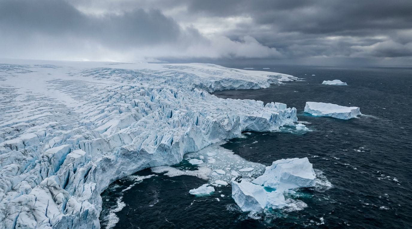
The Thwaites Glacier in West Antarctica is a colossal expanse of ice roughly the size of Great Britain or the state of Florida. For decades, it has been the subject of intense scientific scrutiny and public anxiety, earning the ominous moniker of the "Doomsday Glacier." The stakes are undeniably high: Thwaites currently accounts for about four percent of all annual global sea-level rise, shedding more than 50 billion tons of ice into the ocean each year. If the entire glacier were to collapse, it holds enough water to raise global sea levels by approximately 65 centimeters, a shift that would inundate coastal communities worldwide.[3]
In 2026, a convergence of unprecedented physical exploration and advanced satellite modeling has provided the clearest picture yet of the glacier's trajectory. Through the ongoing efforts of the International Thwaites Glacier Collaboration, researchers have synthesized new data that significantly narrows the timeline for potential collapse. This evidence pack examines the physical data gathered from deep beneath the ice, the satellite observations tracking its surface, and the remaining uncertainties that will dictate the future of global coastlines over the coming century.[3][6]
The primary claim emerging from the 2026 data synthesis is that basal melting at the glacier's grounding line is accelerating due to the deep intrusion of warm ocean water. The grounding line is the critical threshold where the glacial ice leaves the continental bedrock and begins to float on the surface of the ocean as an ice shelf. Because this highly dynamic area is hidden beneath hundreds of meters of solid ice, it has historically been the most difficult region to study, leaving a massive observational blind spot in global climate models.[4][5]

To eliminate this blind spot, an international research team from the United Kingdom and South Korea executed a logistically grueling expedition in early 2026. Led by the British Antarctic Survey and the Korea Polar Research Institute, the team reached the most remote and heavily crevassed main trunk of the Thwaites ice shelf. Using a specialized hot-water drill, the researchers successfully bored a hole 1,000 meters deep through the solid ice, reaching the dark ocean cavity below to directly observe the melting process.[4][5]
This physical breach allowed scientists to deploy a suite of measuring instruments directly at the grounding line. For the first time, researchers are receiving near real-time, continuous data transmitted via satellite regarding the exact temperature, salinity, and velocity of the ocean currents interacting with the ice. The initial readings confirm that unexpectedly warm seawater is penetrating deep beneath the ice shelf, aggressively eroding the glacier from the bottom up and accelerating the inland retreat of the grounding line.[4][5]
The second major claim is that the glacier's surface thinning and overall velocity are increasing at rates that outpace historical predictions. While field teams gathered data from below, a landmark 2026 study published in Geophysical Research Letters utilized high-resolution Earth Observation data from European Space Agency satellites to track the glacier from above. By measuring minute changes in the ice sheet's surface elevation over time, researchers were able to calibrate their predictive models with unprecedented accuracy, replacing broad estimates with hard observational data.[1][2]

The second major claim is that the glacier's surface thinning and overall velocity are increasing at rates that outpace historical predictions.
The findings of this satellite-calibrated modeling are stark. The research indicates that mass loss from Thwaites has grown more than fivefold since the 1990s. The updated simulations suggest that if the current acceleration holds, the glacier could be shedding between 180 and 200 billion tonnes of ice per year within the next 50 years. At that extreme velocity, a single glacier would be losing mass at a rate comparable to the current total ice loss of the entire Antarctic continent.[1][2]
The mechanism driving this rapid acceleration is a phenomenon known as Marine Ice Sheet Instability. Thwaites rests on a bed of continental rock that slopes inward, meaning the bedrock deepens the further inland it goes. As warm ocean water melts the grounding line and forces it to retreat, progressively thicker columns of ice are exposed to the ocean water. Because thicker ice flows faster and is more prone to fracturing, the retreat becomes a dangerous, self-reinforcing cycle that accelerates independently of surface air temperatures.[1]
Once Marine Ice Sheet Instability is triggered, the physics of the retrograde slope dictate that the retreat cannot be easily halted. Even if global atmospheric temperatures were to suddenly stabilize, the thermodynamic momentum of the warm water already circulating in the ocean cavity would continue to eat away at the exposed, deepening ice face. This physical reality is what makes Thwaites the most dangerous glacier on the planet for near-term sea-level rise, as its geometry works against its survival.[1]

Despite these major advances in physical measurement and satellite tracking, a critical layer of transparent uncertainty remains regarding the exact timeline of a full collapse. While the physical mechanisms of the glacier's retreat are now well-documented and understood, the precise speed at which the ice will fail is still the subject of intense scientific debate. Glaciologists note that model uncertainty for Thwaites currently dominates all other variables in global sea-level projections for the next century.[1][2]
The researchers behind the 2026 modeling study emphasize that the choice of calibration data can drastically alter the outcome of the simulations. Depending on how the models weigh certain variables, scenarios can range from a gradual, century-long decline to a rapid, catastrophic failure within decades. The primary goal of the ongoing data synthesis is to tighten these error bars, providing policymakers with a reliable window for coastal adaptation and infrastructure planning before the most severe impacts materialize.[1][2]
Scientists involved in the research are also careful to caution against the paralyzing effects of the Doomsday narrative. While the data points to severe and irreversible changes, fatalistic messaging often leads to public disengagement and political apathy. Researchers stress that while the retreat of Thwaites may be inevitable, the rate of that retreat is still heavily influenced by global carbon emissions. Aggressive climate mitigation can significantly slow the process, buying crucial time for vulnerable cities to build necessary defenses.[1]

The ultimate stakes extend far beyond the 65 centimeters of sea-level rise contained within Thwaites itself. The glacier acts as a structural keystone, a massive cork holding back the broader West Antarctic Ice Sheet. If Thwaites collapses and empties its basin into the Amundsen Sea, it could destabilize a vast network of surrounding glaciers. The ensuing chain reaction would fundamentally redraw global coastlines, threatening the existence of low-lying island nations and major metropolises alike in the coming centuries.[3][4]
How we got here
2018
The US and UK launch the $50 million International Thwaites Glacier Collaboration to study the vulnerable ice shelf.
1990s to 2020s
Satellite data reveals that mass loss from the Thwaites Glacier has grown more than fivefold over three decades.
Jan-Feb 2026
A joint UK-Korea expedition successfully drills 1,000 meters through the ice to place sensors directly at the grounding line.
May 2026
New satellite-calibrated models project the glacier could shed up to 200 billion tonnes of ice annually within 50 years.
Viewpoints in depth
Glaciologists & Modelers
Computational scientists focused on integrating new data to reduce the massive uncertainties in century-scale sea-level projections.
For the modeling community, Thwaites represents the ultimate test of predictive physics. Because the glacier's dynamics are so complex, historical models have shown massive disagreement regarding its future trajectory. By feeding new, high-resolution satellite altimetry data into artificial intelligence-assisted models, these scientists are finally narrowing the error bars. They argue that precision is paramount; a difference of a few decades in a collapse timeline fundamentally alters how global governments must allocate trillions of dollars for coastal defense.
Field Researchers
Scientists conducting in-situ physical measurements in Antarctica's most hostile environments.
Field teams argue that satellites alone cannot capture the thermodynamic realities occurring hundreds of meters beneath the ice. By executing logistically grueling missions—such as flying 25 tons of equipment to a heavily crevassed zone to drill a 1,000-meter hole—they are securing the ground-truth data that models desperately need. For these researchers, the priority is understanding the exact temperature, salinity, and current velocity of the water intruding at the grounding line, which dictates the fundamental speed of basal melting.
Coastal Planners & Policymakers
Stakeholders who must translate glacial retreat timelines into actionable infrastructure and economic policies.
For policymakers, the abstract physics of Marine Ice Sheet Instability translate directly into municipal survival. They rely on the synthesis of field data and modeling to determine whether to build sea walls, elevate infrastructure, or begin managed retreats from vulnerable coastlines. This camp emphasizes the need for clear, actionable timelines over scientific jargon, noting that the difference between a 50-year and a 150-year collapse scenario dictates whether current coastal investments are viable or futile.
What we don't know
- The precise decade when the glacier's retreat will cross the threshold of irreversible, rapid collapse.
- Exactly how much the destabilization of Thwaites will accelerate the melting of the broader West Antarctic Ice Sheet.
- Whether localized ocean current shifts could temporarily slow the intrusion of warm water into the ice cavity.
Key terms
- Grounding Line
- The critical point where a glacier leaves the bedrock and begins to float on the ocean surface as an ice shelf.
- Basal Melting
- The process of warm ocean water melting the underside of a floating ice shelf or glacier.
- Marine Ice Sheet Instability (MISI)
- A self-reinforcing process where a glacier retreating down a reverse-sloping seabed accelerates its own collapse.
- Earth Observation (EO)
- The gathering of information about planet Earth's physical, chemical, and biological systems via remote sensing technologies, usually satellites.
Frequently asked
Why is Thwaites called the Doomsday Glacier?
It earned the nickname because of its massive size and the severe global consequences of its potential collapse, though many scientists prefer to avoid the term as it can cause fatalism.
How much will sea levels rise if Thwaites melts?
The complete collapse of Thwaites would raise global sea levels by approximately 65 centimeters (about two feet), but it could also trigger the loss of surrounding glaciers, leading to multi-meter rises.
What did the 2026 drilling mission accomplish?
A UK-Korea team successfully used a hot-water drill to bore 1,000 meters through the ice, placing sensors directly at the grounding line to measure ocean temperatures and currents in real-time.
Can the melting of Thwaites be stopped?
Because the glacier rests on a reverse-sloping seabed, its retreat may be self-reinforcing. However, reducing global greenhouse gas emissions can still significantly slow the rate of collapse, buying time for coastal adaptation.
Sources
Source coverage
6 outlets
3 viewpoints surfaced


[1]ScienceNews.dkGlaciologists & Modelers
One Antarctic glacier could soon lose mass at the same rate as the entire continent
Read on ScienceNews.dk →[2]European Space AgencyGlaciologists & Modelers
Model training with Earth Observation dramatically affects predictions
Read on European Space Agency →[3]National Snow and Ice Data CenterCoastal Planners & Policymakers
The International Thwaites Glacier Collaboration
Read on National Snow and Ice Data Center →[4]Polar JournalField Researchers
Meet the UK-Korea team drilling through unstable Thwaites Glacier
Read on Polar Journal →[5]British Antarctic SurveyField Researchers
Scientists' drilling mission on remote and inaccessible glacier
Read on British Antarctic Survey →[6]Factlen Editorial TeamCoastal Planners & Policymakers
Synthesis by Factlen editorial team
Read on Factlen Editorial Team →

Every angle. Every day.
Get science stories with full source coverage and perspective breakdowns delivered to your inbox.