How Lasers Revealed a Network of Ancient Cities Hidden Beneath the Amazon
Airborne LiDAR technology has digitally stripped away the Amazon canopy, revealing 2,500-year-old urban centers, massive pyramids, and complex road networks. The discoveries are fundamentally rewriting the history of the Americas and proving the rainforest was once home to millions.
By Factlen Editorial Team
- Archaeological Consensus
- Focuses on the hard data, LiDAR mapping, and structural evidence of massive urbanism.
- Ecological Historians
- Focuses on Terra Preta, garden urbanism, and sustainable forest management.
- Public Science Communicators
- Focuses on the paradigm shift and correcting the 'green desert' myth for the general public.
What's not represented
- · Modern Indigenous communities living in the region today
- · Agricultural policymakers looking to implement Terra Preta techniques
Why this matters
For centuries, Western history dismissed the Amazon as a pristine wilderness incapable of supporting complex civilization. These discoveries restore the legacy of Indigenous urbanism, proving that humans can build thriving, large-scale societies in harmony with the rainforest rather than destroying it.
Key points
- Airborne LiDAR technology has allowed archaeologists to digitally deforest the Amazon, revealing massive ancient urban centers hidden beneath the canopy.
- In Ecuador's Upano Valley, researchers discovered a 2,500-year-old network of 6,000 earthen platforms connected by straight, 33-foot-wide roads.
- The ancient Amazonians practiced 'garden urbanism,' enriching the poor rainforest soil with compost and charcoal to create highly fertile Terra Preta.
- These discoveries overturn the long-held myth that the Amazon was an untouched wilderness, proving it supported complex, sustainable civilizations for millennia.
For centuries, Western historians and ecologists shared a fundamental assumption about the Amazon rainforest: it was a pristine, untouched wilderness. The prevailing narrative depicted a 'green desert' with soil too poor and a climate too harsh to support anything more than small, nomadic tribes.[3][4]
This assumption shaped global understanding of pre-Columbian history, suggesting that while the Maya and Inca built towering empires of stone, the Amazon remained a demographic void.[3][6]
But beneath the dense, impenetrable canopy, a radically different story was waiting to be told. Over the past few years, a revolutionary remote-sensing technology has allowed archaeologists to effectively see through the trees, uncovering a sprawling network of ancient cities that rivaled the Roman Empire in their scale and longevity.[2][7]
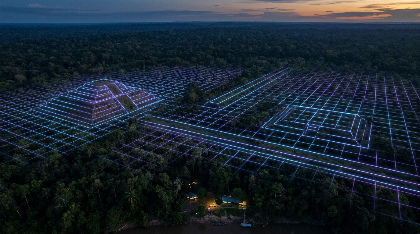
The breakthrough comes courtesy of LiDAR, or Light Detection and Ranging. To map the forest floor, researchers mount a laser scanner to the belly of an aircraft. As the plane flies over the jungle, it fires hundreds of thousands of infrared laser pulses per second down into the canopy.[4][6]

While most of the light hits leaves and branches, a fraction reaches the ground and bounces back. By measuring the exact time it takes for those pulses to return, powerful computers can digitally strip away the vegetation, generating high-resolution, three-dimensional maps of the earth beneath.[5][6]
'It's a gift for an archaeologist,' notes Stéphen Rostain, a director of research at the French National Center for Scientific Research (CNRS). For decades, Rostain had trekked through the jungle on foot, identifying isolated mounds but struggling to see the bigger picture. LiDAR provided the missing perspective without requiring a single tree to be cut down.[1][5]
When the LiDAR data for Ecuador's Upano Valley was finally processed, the results stunned the scientific community. The lasers revealed a densely populated, highly organized urban landscape dating back to 500 BCE.[1][2]
The scans exposed more than 6,000 rectangular earthen platforms arranged meticulously around central plazas. These structures served as home foundations, ceremonial centers, and communal workspaces for a society that thrived for over a millennium.[1][2]
The scans exposed more than 6,000 rectangular earthen platforms arranged meticulously around central plazas.
Even more astonishing was the infrastructure connecting them. The Upano settlements were linked by a vast web of perfectly straight roads, some measuring up to 33 feet wide and stretching for 15 miles. Rather than following the natural contours of the land, these highways cut directly through hills and ravines, indicating a highly centralized system of urban planning and mass labor.[1][4]

The Upano Valley is not an isolated anomaly. Further south, in the Llanos de Mojos region of the Bolivian Amazon, LiDAR scans have unveiled the monumental architecture of the Casarabe culture, which flourished between 500 and 1400 CE.[4][6]
There, ancient engineers constructed pyramidal mounds towering 65 feet high, surrounded by intricate defensive moats, raised causeways, and massive water-control reservoirs designed to manage the region's intense seasonal flooding.[1][6]
These discoveries raise an immediate question: how did ancient societies feed tens of thousands of people in a rainforest notorious for its nutrient-poor soil? The answer lies in a concept researchers call 'garden urbanism.'[2][7]
Rather than clear-cutting the forest to build concrete metropolises, ancient Amazonians integrated their cities into the ecosystem. They engineered the landscape by creating 'Terra Preta,' or dark earth—a highly fertile, human-made soil enriched with compost, charcoal, and organic waste.[6][7]

This ingenious agricultural technology allowed them to grow maize, sweet potatoes, and other crops continuously without depleting the land, supporting peak populations that may have reached into the millions across the wider Amazon basin.[3][6]
If these civilizations were so massive and successful, their disappearance remains one of history's great tragedies. While some individual settlements were likely abandoned due to volcanic eruptions or localized climate shifts, the ultimate collapse was brought on by outside forces.[5][7]
In the 16th century, European explorers arrived in South America. The diseases they brought with them, such as smallpox, swept through the continent's trade networks far faster than the colonizers themselves, decimating the dense urban populations of the Amazon before most Europeans ever laid eyes on them.[3][7]
Because these cities were constructed from earth and wood rather than stone, the jungle quickly reclaimed them. Within a few generations, the massive pyramids and wide highways were swallowed by roots and vines, hiding the evidence of their existence for centuries.[3][7]
Today, the LiDAR revolution is doing more than just correcting the historical record; it is offering a vital blueprint for the future. The ancient Amazonians proved that it is entirely possible to sustain large, complex human populations in the rainforest without destroying the ecosystem—a lesson in sustainable urbanism that modern society desperately needs to learn.[5][7]
How we got here
500 BCE
The Upano Valley culture begins building complex earthen platforms and road networks in modern-day Ecuador.
500 CE
The Casarabe culture emerges in the Bolivian Amazon, constructing massive pyramidal mounds and causeways.
1500s CE
European explorers arrive in South America; introduced diseases begin to decimate Indigenous populations, leading to the abandonment of remaining cities.
1970s
Archaeologists like Stéphen Rostain begin finding isolated earthen mounds on foot, though the scale remains unknown.
2015
The first major LiDAR surveys of the Upano Valley are conducted, digitally stripping away the canopy.
2024
A landmark study in the journal Science officially details the 2,500-year-old Upano cities, shifting the global archaeological consensus.
Viewpoints in depth
Archaeological Consensus
Researchers emphasize that the sheer volume of LiDAR data fundamentally rewrites the timeline of human complexity in the Americas.
For decades, the lack of stone ruins led archaeologists to assume the Amazon was a demographic void. The new consensus, driven by LiDAR, is that earth and wood were the primary building materials for highly organized societies. Researchers point to the precise right angles of the Upano roads and the massive water-control reservoirs of the Casarabe as undeniable proof of centralized urban planning, requiring thousands of coordinated laborers.
Ecological Historians
This camp focuses on how these ancient societies engineered the landscape to support massive populations without destroying the rainforest.
Rather than clear-cutting the forest to build concrete jungles, ancient Amazonians practiced 'garden urbanism.' They enriched the naturally poor soil with compost and charcoal to create Terra Preta, allowing for continuous, high-yield agriculture. Ecologists argue that these discoveries prove humans can live in dense populations within the Amazon sustainably, offering vital lessons for modern conservation and agriculture.
Indigenous Knowledge Advocates
Advocates highlight that the 'discovery' of these cities validates long-held Indigenous oral histories.
Long before LiDAR, early European accounts and Indigenous oral traditions spoke of vast, populous cities along the Amazonian rivers. These accounts were largely dismissed as myths or exaggerations by 20th-century historians. Advocates argue that the new scientific evidence should prompt a broader respect for Indigenous historical memory, recognizing that today's forest communities are the survivors of a post-contact apocalypse rather than 'primitive' isolates.
What we don't know
- The exact population of the entire Amazon basin before European contact remains heavily debated, with estimates ranging from a few million to upwards of 20 million.
- Because these societies left no written records, their political structures, religious beliefs, and the specific reasons for the abandonment of certain pre-contact sites remain a mystery.
Key terms
- LiDAR
- A remote sensing technology that uses rapid laser pulses to map the surface of the earth, capable of 'seeing through' dense forest canopies.
- Terra Preta
- Highly fertile, human-made 'dark earth' created by ancient Amazonians using a mix of charcoal, compost, and pottery shards to farm in nutrient-poor rainforests.
- Garden Urbanism
- A model of city planning where dense human settlements are integrated with agricultural plots and managed forests, rather than replacing the natural environment.
- Pre-Columbian
- The time period in the history of the Americas before the arrival of Christopher Columbus and European colonizers.
Frequently asked
What is LiDAR and how does it find ruins?
LiDAR stands for Light Detection and Ranging. Aircraft fire millions of laser pulses at the ground; by measuring how long they take to bounce back, computers can filter out the trees and reveal the 3D shape of the earth underneath.
Why didn't explorers find these cities earlier?
Unlike the stone pyramids of the Maya or Inca, Amazonian cities were built using earth and wood. After the populations collapsed, the jungle quickly overgrew the earthen mounds, making them nearly invisible from the ground.
How many people lived in these ancient Amazon cities?
Estimates vary by region, but archaeologists believe the Upano Valley sites alone housed between 10,000 and 30,000 people, while the broader Amazon basin may have supported millions before European contact.
What happened to the people who built them?
While some settlements were abandoned due to climate shifts or volcanic eruptions, the vast majority of the Amazon's population was decimated by European diseases like smallpox in the 16th and 17th centuries.
Sources
Source coverage
7 outlets
3 viewpoints surfaced


[1]CNRS NewsArchaeological Consensus
Ancient cities in the Amazon
Read on CNRS News →[2]ScienceArchaeological Consensus
Two thousand years of garden urbanism in the Upper Amazon
Read on Science →[3]BBC Science FocusPublic Science Communicators
The hidden ancient mega-cities of the Amazon are finally revealing their secrets
Read on BBC Science Focus →[4]Smithsonian MagazineEcological Historians
Lost Cities of the Amazon Discovered From the Air
Read on Smithsonian Magazine →[5]CBC RadioPublic Science Communicators
Deep in the Amazon, researchers have uncovered a complex of ancient cities — using laser technology
Read on CBC Radio →[6]Ancient OriginsEcological Historians
Lidar Scans Reveal Many Lost Cities, Thousands of Earthworks in the Amazon
Read on Ancient Origins →[7]Factlen Editorial TeamArchaeological Consensus
Synthesis by Factlen editorial team
Read on Factlen Editorial Team →

Every angle. Every day.
Get culture stories with full source coverage and perspective breakdowns delivered to your inbox.