How Century-Old Maritime Logbooks Are Helping Scientists Predict the Next El Nino
Climatologists are turning to the meticulous records of a 1920s British research ship and a 19th-century whaling captain to calibrate modern climate models. These historical observations provide a crucial baseline for understanding how ocean currents behave in a warming world.
By Factlen Editorial Team
- Climate Modellers
- Rely on historical data to calibrate modern predictive models.
- Marine Historians
- View maritime logbooks as invaluable, untapped scientific artifacts.
- Oceanographers
- Focus on the physical mechanisms of ocean currents and their global impacts.
What's not represented
- · Indigenous Arctic communities whose historical knowledge of ice patterns predates European whaling.
- · Modern coastal communities directly threatened by the intensifying El Nino weather patterns.
Why this matters
To accurately predict how climate change and El Nino will affect our future weather, scientists must understand how the Earth behaved before industrialization. The meticulous records kept by early maritime explorers provide the crucial baseline data needed to make these life-saving forecasts.
Key points
- The UN has warned of a newly intensifying El Nino phase, prompting scientists to refine predictive models.
- Climatologists are using century-old data from the British research ship William Scoresby to understand historical ocean currents.
- The ship's namesake, a 19th-century whaling captain, also left behind invaluable logs of Arctic temperatures and sea ice.
- Historical logbooks act as a crucial calibration tool for proxy data like ice cores and tree rings.
- This foundational data helps researchers separate natural climate variability from human-induced warming.
The United Nations' recent warnings about a newly intensifying El Nino phase have sent climatologists scrambling to refine their predictive models. But to understand how the Pacific's warming currents will behave in a modern, greenhouse-gas-heavy atmosphere, researchers are turning to a surprising source: a century-old British research vessel.[1][5]
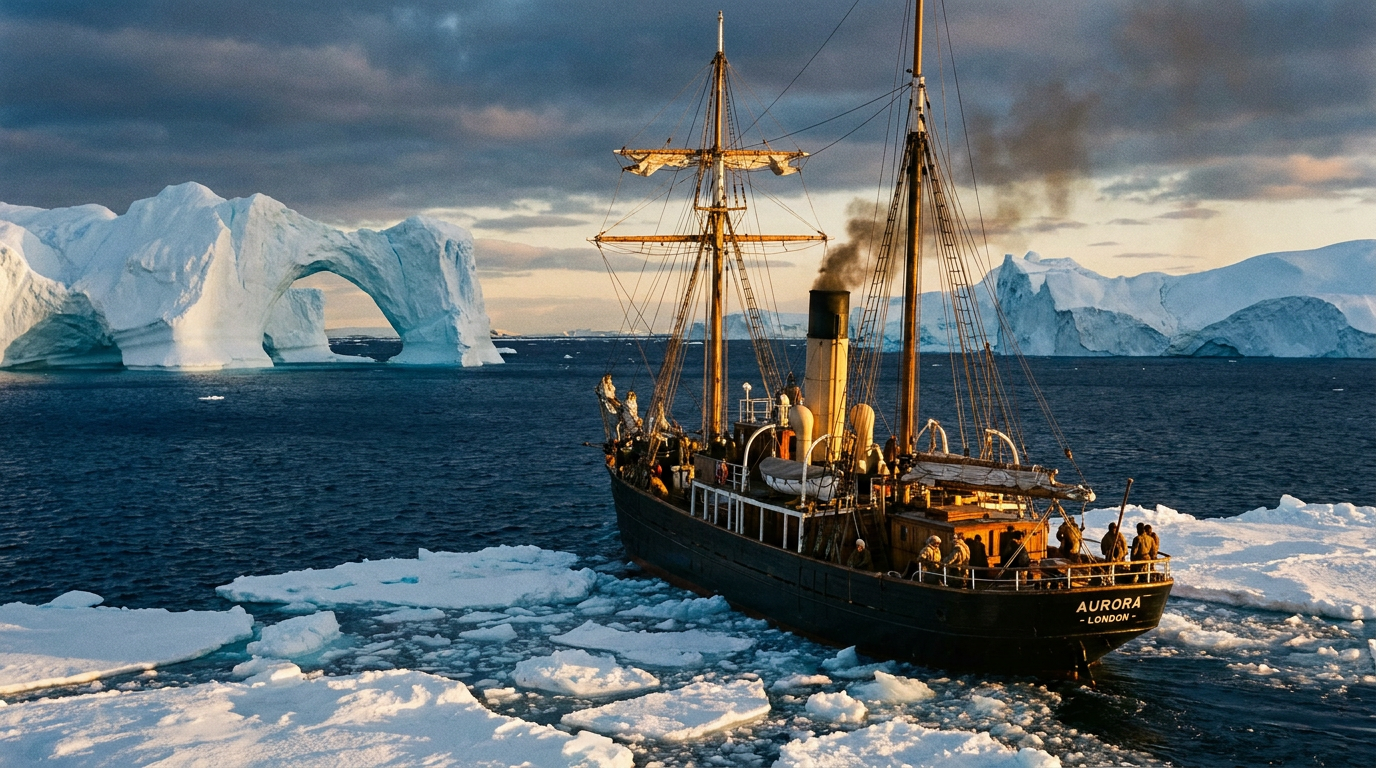
A hundred years ago this month, in June 1926, the Royal Research Ship William Scoresby launched from Humber Dock in Hull, England. Built specifically to explore the harsh environments of the southern oceans, the ship embarked on a series of grueling voyages that would inadvertently lay the groundwork for modern climate science.[1][5]
El Nino is a natural climate phenomenon characterized by the warming of surface waters in the eastern Pacific Ocean, specifically along the equator. This warming disrupts normal atmospheric circulation, triggering extreme weather globally—from severe droughts in Australia to catastrophic heavy rainfall in South America.[7]

During a grueling 19-month expedition in the 1930s, the crew of the William Scoresby meticulously measured the Humboldt Current—the cold-water current off the coast of South America—and its warm-water counterpart, El Nino. According to researchers at the University of Hull, the physical measurements taken of these deeper ocean layers provided the first accurate delineation of the currents.[1][6]
Why does century-old data matter today? Modern climate models rely on establishing a baseline—a record of how the Earth's systems behaved before widespread industrial carbon emissions altered the atmosphere. The Scoresby's precise oceanographic readings offer a rare, high-fidelity snapshot of the Pacific's natural variability.[1][7]
The ship's legacy is doubly significant because of its namesake: William Scoresby Jr., a 19th-century English whaling captain, clergyman, and scientist. Born in 1789, Scoresby Jr. was a pioneer in his own right, making some of the earliest systematic observations of Arctic temperatures, terrestrial magnetism, and sea ice.[4]
In the early 1800s, Scoresby Jr. used a custom-built ten-gallon fir cask to measure ocean temperatures at various depths. He made the groundbreaking discovery that polar waters are actually warmer at great depths than at the surface—defying the conventional wisdom of the era, which assumed the ocean grew uniformly colder with depth.[4][7]
used a custom-built ten-gallon fir cask to measure ocean temperatures at various depths.
Today, climatologists are digitizing Scoresby Jr.'s whaling logbooks to reconstruct the Arctic climate of 1810–1825. This period is critical because it coincided with the Dalton Minimum—a period of low solar activity—and the massive 1815 eruption of Mount Tambora, which caused significant global cooling.[2]

Reconstructing historical climates usually relies on proxies like tree rings, ice cores, and coral reefs. However, proxy data can be noisy, and researchers often disagree on the exact magnitude of historical temperature shifts.[2][7]
Direct observational records—like the daily temperature, wind, and ice logs kept by Scoresby—act as a crucial calibration tool for these proxies. Because Scoresby was a scientifically educated observer who used reliable instruments, his logbooks provide a compelling and precise source of information on early 19th-century climate variability.[2]
Projects like ARCdoc at the University of Sunderland have used Scoresby's meticulous definitions of sea ice to map the early 19th-century Arctic ice front. By tracing every sea ice definition in UK maritime history, researchers have been able to build a clearer picture of the Arctic under purely natural weather conditions.[3]

By comparing his logs to modern satellite data, scientists have confirmed that while the 1810s were significantly colder with abundant sea ice, the region still experienced dramatic natural fluctuations. For instance, Scoresby recorded massive clearings of sea ice in the Greenland Sea following the Tambora eruption, highlighting the complex dynamics of the polar climate.[2][3]
Together, the 19th-century Arctic logs of the man and the 20th-century Pacific data of the ship form a vital bridge across time. They allow scientists to separate natural, cyclical climate fluctuations from the unprecedented, human-induced warming we are experiencing today.[3][7]
As the world braces for more frequent and severe El Nino events, the data collected by the William Scoresby is being fed into supercomputers to refine modern predictive models. Understanding exactly how the Humboldt and El Nino currents interacted a century ago helps forecasters predict how they will behave as global temperatures continue to rise.[1][5]

The forgotten voyages of the William Scoresby—and the whaling captain it was named after—demonstrate that the key to predicting our climate future often lies buried in the logbooks of our past. It is a testament to the enduring value of meticulous, curiosity-driven science, proving that observations made a century ago can still save lives today.[1][7]
How we got here
1810–1822
Whaling captain William Scoresby Jr. makes systematic weather and ice observations in the Arctic.
1820
Scoresby Jr. publishes his comprehensive findings in 'An Account of the Arctic Regions'.
June 1926
The Royal Research Ship William Scoresby is launched from Hull, England.
1930s
The William Scoresby spends 19 months examining the Humboldt and El Nino currents in the Pacific.
2014
The ARCdoc project uses Scoresby's logbooks to map early 19th-century Arctic ice fronts.
June 2026
Climatologists highlight the ship's century-old data as crucial for predicting a newly intensifying El Nino phase.
Viewpoints in depth
Climate Modellers
Rely on historical data to calibrate modern predictive models.
For climate modellers, the primary challenge is separating natural cyclical variability from anthropogenic warming. Proxy data like ice cores and tree rings provide a broad picture, but they lack the granular, day-by-day precision of instrumental records. By integrating the exact temperature and wind measurements from ships like the William Scoresby, modellers can fine-tune their algorithms, significantly reducing the margin of error when forecasting future El Nino events.
Marine Historians
View maritime logbooks as invaluable, untapped scientific artifacts.
Historians emphasize that early explorers were often meticulous scientists in their own right. The logbooks of whaling captains and naval officers were a matter of life and death, requiring precise observations of ice fronts, wind directions, and ocean currents. Today, these archives represent a treasure trove of baseline environmental data, proving that historical preservation is a critical component of modern climate science.
Oceanographers
Focus on the physical mechanisms of ocean currents and their global impacts.
Oceanographers study the complex interactions between currents like the cold Humboldt and the warm El Nino. The foundational measurements taken by the William Scoresby in the 1930s provided the first three-dimensional understanding of these water masses. Modern oceanography builds directly on this legacy, using autonomous gliders and satellite telemetry to track the very same currents that early researchers mapped with wooden casks and weighted lines.
What we don't know
- How exactly the intensifying El Nino will interact with unprecedented modern baseline temperatures.
- The full extent of undiscovered climate data still sitting un-digitized in maritime archives around the world.
- Whether proxy data reconstructions can ever fully align with the precise instrumental records from the early 19th century.
Key terms
- El Nino
- A natural climate pattern involving the warming of surface waters in the eastern Pacific Ocean, which significantly influences global weather.
- Humboldt Current
- A cold, low-salinity ocean current that flows north along the western coast of South America.
- Proxy data
- Preserved physical characteristics of the environment, like tree rings or ice cores, that stand in for direct meteorological measurements.
- Dalton Minimum
- A period of low solar activity from roughly 1790 to 1830, which coincided with lower global temperatures.
- Fir-cask
- A wooden barrel used by early oceanographers to capture and insulate seawater from specific depths for temperature measurement.
Frequently asked
What was the William Scoresby?
It was a British Royal Research Ship launched in 1926 that conducted pioneering oceanographic work, including early measurements of the El Nino current.
Who was William Scoresby Jr.?
He was a 19th-century English whaling captain and scientist who made some of the first systematic temperature and ice observations in the Arctic.
Why are historical ship logbooks important for climate change?
They provide direct, observational weather data from before the industrial era, helping scientists calibrate modern climate models and proxy data like ice cores.
How did Scoresby measure ocean temperatures in the 1800s?
He used a custom-built wooden fir cask with valves to trap seawater at various depths, proving that polar waters are warmer deep down than at the surface.
Sources
Source coverage
7 outlets
3 viewpoints surfaced


[1]BBCMarine Historians
How forgotten voyages helped track El Nino
Read on BBC →[2]Climate of the PastClimate Modellers
Arctic weather 1810–1825: proxy reconstructions and observational records
Read on Climate of the Past →[3]ScienceDailyClimate Modellers
Whalers' logbooks reveal early 19th century Arctic ice extent
Read on ScienceDaily →[4]Encyclopaedia BritannicaOceanographers
William Scoresby: English explorer and scientist
Read on Encyclopaedia Britannica →[5]Yahoo NewsMarine Historians
How forgotten voyages helped track El Nino
Read on Yahoo News →[6]Falkland Islands National ArchivesOceanographers
The Work of the William Scoresby
Read on Falkland Islands National Archives →[7]Factlen Editorial TeamOceanographers
Synthesis by Factlen editorial team
Read on Factlen Editorial Team →
Every angle. Every day.
Get science stories with full source coverage and perspective breakdowns delivered to your inbox.