How AI is Catching Wildfires Before the First 911 Call
A new generation of AI-enabled cameras and satellites is detecting wildfires within minutes of ignition, giving first responders a critical head start that is preventing mega-fires.
By Factlen Editorial Team
- Emergency Management Agencies
- First responders prioritize rapid detection to deploy resources efficiently and keep fires small.
- Firetech Innovators
- Technology developers focus on scaling detection networks and improving algorithmic accuracy.
- Forestry & Climate Scientists
- Scientists emphasize that while AI is a crucial adaptation, it does not solve the root causes of wildfires.
What's not represented
- · Insurance Providers
- · Local Residents in High-Risk Areas
Why this matters
As climate change fuels longer and more destructive fire seasons, early detection is the difference between a minor brush fire and a catastrophic mega-fire. This technology is actively saving homes, protecting drinking water supplies, and reducing the massive financial burden of prolonged firefighting operations.
Key points
- Networks of AI-enabled cameras are now detecting wildfires up to 45 minutes faster than traditional 911 calls.
- Systems like ALERTCalifornia and Pano AI use computer vision to spot smoke plumes and instantly triangulate exact coordinates for dispatchers.
- Early detection allows fire crews to launch rapid aerial attacks, successfully containing blazes like Colorado's Bear Creek Fire to just three acres.
- New satellite constellations, such as Google's FireSat, are expanding this capability to orbit, scanning the globe for thermal anomalies smaller than a soccer field.
The traditional method of spotting wildfires—waiting for a human observer to notice a plume of smoke and dial 911—is increasingly inadequate in an era of climate-fueled mega-fires. By the time a hiker or passing motorist spots a blaze, the fire has often already consumed acres of dry vegetation and generated enough heat to create its own weather patterns. In remote or rugged terrain, a fire might burn unnoticed for hours, rendering rapid containment strategies nearly impossible by the time emergency dispatchers are finally alerted.
But a quiet, highly effective revolution is currently taking place on mountain peaks and in low Earth orbit. Artificial intelligence is now actively scanning the wilderness, identifying the earliest wisps of smoke and thermal anomalies long before human observers realize a threat exists. By combining high-definition optical sensors with deep learning algorithms, these systems are fundamentally changing the math of disaster response. They are shifting the paradigm from reactive firefighting to proactive, algorithmic early warning, proving across the American West, Australia, and Europe that saving minutes can save thousands of acres.
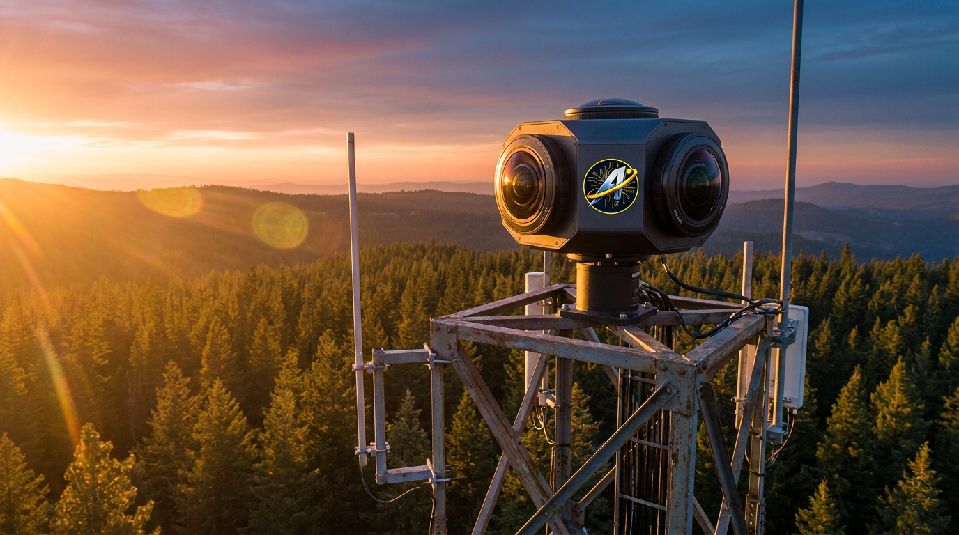
At the ground level, this technological shift relies on vast networks of high-definition, 360-degree cameras placed on strategically elevated vantage points. The ALERTCalifornia initiative, for example, operates a sprawling network of roughly 1,240 AI-enabled cameras across the state. These devices maintain a constant vigil over high-risk, sparsely populated areas where a spark might otherwise go unnoticed. The hardware is robust, designed to withstand extreme weather and high winds while continuously feeding high-resolution visual data back to centralized command centers for real-time analysis.[1]
Instead of relying on humans to stare at hundreds of video feeds, the system feeds millions of images into computer vision algorithms trained specifically to recognize the visual signature of smoke. According to Neal Driscoll, a geology and geophysics professor at the University of California, San Diego, and the founder of ALERTCalifornia, the AI running on these cameras is consistently beating traditional emergency reporting. The algorithms can detect the subtle, shifting patterns of a nascent smoke plume against complex backgrounds like moving clouds or dense forest canopies.[1]

The impact in the field has been immediate, measurable, and highly consequential for first responders. In Arizona, meteorologists working with local utility companies report that the AI technology notifies them about 45 minutes faster, on average, than the first public 911 call. That margin is the difference between dispatching a single helicopter to drop water on a localized brush fire and mobilizing hundreds of firefighters to battle an uncontrollable inferno that threatens entire communities. Early detection allows agencies to keep fires small, dramatically reducing the financial cost and physical danger associated with prolonged firefighting campaigns.[2]
A textbook example of this technology in action occurred during the Bear Creek Fire in Douglas County, Colorado. A sudden lightning strike ignited a blaze in remote, rugged terrain that threatened a critical watershed supplying drinking water to over a million residents. Pano AI, a San Francisco-based startup that provides advanced detection infrastructure, spotted the smoke within minutes of ignition. The system instantly triangulated the exact coordinates of the anomaly and delivered real-time video to emergency managers, completely bypassing the traditional reliance on civilian observation.[3]
That automated alert reached dispatchers 21 minutes before the official emergency system was activated by other means. That 21-minute head start allowed fire crews to launch a rapid, highly coordinated aerial and ground attack, containing the fire to just three acres. Emergency managers involved in the response noted that without the precise coordinates and early warning provided by the AI, the blaze could easily have escalated into a highly destructive and costly event, potentially compromising the region's water supply and forcing mass evacuations.[3]
That automated alert reached dispatchers 21 minutes before the official emergency system was activated by other means.
Similar operational successes are being recorded by forestry agencies across the Pacific Northwest. The Washington State Department of Natural Resources deployed AI cameras that successfully flagged the Warden Fire in Mason County before a single 911 call was placed. By providing instant situational awareness and exact mapping, the technology allowed crews to hold the fire to under 16 acres with zero structural loss. Feedback from dispatchers highlighted how the system eliminated the chaotic guesswork often associated with locating a fire reported vaguely by a panicked caller.[4]

While ground-based camera networks monitor the horizon, a parallel and equally ambitious effort is taking place in space. Google Research has partnered with the Earth Fire Alliance and Muon Space to develop FireSat, a purpose-built satellite constellation designed specifically to scan the globe for thermal anomalies. Traditional satellite imagery used for firefighting is often hampered by low resolution or infrequent orbital passes, making it nearly impossible to detect a fire until it has grown to a substantial size and generated massive heat signatures.[5]
FireSat aims to close that critical gap. The constellation, which launched its first prototype in early 2025, uses high-resolution multispectral imagery combined with advanced AI to detect fires smaller than a standard soccer field. By comparing current images with thousands of historical images of the exact same location, the AI can reliably determine if a new heat signature represents a genuine threat, providing near real-time insights to first responders anywhere on the planet, regardless of how remote the ignition point might be.[5]
The European Space Agency is also advancing orbital detection capabilities with its PhiFireAI application. Rather than beaming massive amounts of raw imagery back to Earth for analysis, the system processes images directly onboard the satellite using convolutional neural networks. The application autonomously identifies burnt areas, active flames, and safe zones, only downlinking data when a threat is confirmed. This onboard processing saves precious transmission time and bandwidth, ensuring that actionable intelligence reaches relevant authorities without delay. It also enriches global wildfire databases, allowing scientists to study fire propagation and improve predictive models for future fire seasons.[6]
Despite the algorithmic heavy lifting, these systems are not fully autonomous, nor are they designed to be. They rely heavily on a 'human-in-the-loop' model to prevent false alarms from triggering unnecessary and expensive emergency responses. When the AI flags a potential fire, human analysts quickly review the footage to verify that the anomaly is actually smoke, rather than a low-hanging cloud, kicked-up dust from a construction site, or exhaust from heavy agricultural machinery. This human verification step is crucial for maintaining the trust of local fire departments.[1][2]

This collaborative approach keeps the rate of false positives exceptionally low while continuously generating valuable training data. Every time a human confirms or rejects an AI alert, the machine learning models become slightly more accurate. The ultimate goal of the technology is not to replace human dispatchers or fire lookouts, but to augment their capabilities, giving them the tools to process vast amounts of environmental data instantly and make life-saving decisions with unprecedented speed. It acts as an tireless digital sentry that never blinks, never sleeps, and can monitor thousands of square miles simultaneously.[1][7]
The undeniable success of these early-warning systems has attracted significant institutional capital, accelerating their deployment. Pano AI recently closed a $44 million Series B funding round, bringing its total financing to $89 million. The company is using the capital to rapidly expand its global footprint, which already actively protects nearly 30 million acres of vulnerable landscapes across the United States, Canada, and Australia, partnering with major utilities and hundreds of first-responder agencies. This influx of investment signals a broader market consensus that climate adaptation technology is transitioning from experimental pilot projects to essential public safety infrastructure.[3][7]
Yet, environmental experts and forestry scientists caution that artificial intelligence is ultimately a mitigation tool, not a comprehensive cure. While early detection is absolutely critical for saving lives and property, it does not address the underlying, systemic conditions driving the modern wildfire crisis. Decades of forest mismanagement, accumulated fuel loads, and a rapidly warming climate create environments where even the fastest detection cannot always prevent a fire from exploding into a catastrophic event. AI can spot the spark, but it cannot remove the dry timber or lower the ambient temperatures that allow fires to thrive.[7]

Still, as fire seasons grow longer, hotter, and more severe, the ability to catch a spark before it becomes an inferno remains one of the most effective and immediate defenses available to modern society. As artificial intelligence integration deepens across both ground sensors and satellite networks, the line between standard wildfire detection and AI-driven response will soon disappear entirely, offering a powerful new layer of resilience for communities living on the edge of the wildland-urban interface. By buying first responders the most precious resource in any emergency—time—these systems are proving that technology can meaningfully push back against the escalating threats of a changing climate.[1][7]
How we got here
2023
DigitalPath's AI begins operating across California's CAL FIRE command centers, processing millions of images daily.
June 2024
Pano AI detects the Bear Creek Fire in Colorado, giving crews a 21-minute head start to contain the blaze to just three acres.
March 2025
The first prototype satellite for the FireSat constellation launches to test orbital AI detection.
Mid-2026
AI detection networks expand globally, with systems actively protecting tens of millions of acres across North America and Australia.
Viewpoints in depth
Emergency Management Agencies
First responders prioritize rapid detection to deploy resources efficiently and keep fires small.
For emergency dispatchers and fire chiefs, the value of AI lies entirely in the time it buys them. Traditional emergency response relies on civilian 911 calls, which are often delayed, geographically imprecise, and prone to panic-induced inaccuracies. By receiving exact GPS coordinates and real-time video feeds within minutes of ignition, agencies can launch targeted 'helitack' operations—dropping water from helicopters before a fire spreads beyond a few acres. This rapid response not only saves lives and property but also drastically reduces the financial burden of prolonged, multi-week firefighting campaigns.
Firetech Innovators
Technology developers focus on scaling detection networks and improving algorithmic accuracy.
The companies and space agencies building these systems view the wildfire crisis as a data problem that can be solved with sufficient sensor coverage and computing power. Their primary focus is on expanding the hardware footprint—deploying thousands of ground cameras and launching dedicated satellite constellations like FireSat. They are also constantly refining their machine learning models to reduce false positives, ensuring that the AI can distinguish between a genuine smoke plume and a low-hanging cloud, thereby maintaining the trust of the agencies that rely on their alerts.
Forestry & Climate Scientists
Scientists emphasize that while AI is a crucial adaptation, it does not solve the root causes of wildfires.
While celebrating the tactical victories enabled by early detection, climate scientists and forestry experts maintain a broader, more cautionary perspective. They point out that AI is a mitigation strategy, not a cure for the underlying conditions driving the modern wildfire crisis. Decades of fire suppression have left forests overloaded with dry fuel, while climate change continues to extend fire seasons and increase ambient temperatures. From this viewpoint, AI cameras are an essential band-aid, but long-term resilience requires systemic changes in land management, controlled burns, and global emissions reductions.
What we don't know
- How effectively satellite-based AI detection will perform during heavy cloud cover or massive regional smoke events that obscure orbital visibility.
- Whether smaller, underfunded rural fire departments will be able to afford the subscription costs associated with private AI detection platforms once grant funding expires.
Key terms
- Computer Vision
- A field of artificial intelligence that trains computers to interpret and understand visual information from the world, such as identifying smoke in a camera feed.
- Multispectral Imagery
- Image data captured across multiple wavelengths of the electromagnetic spectrum, including infrared, which helps satellites detect heat signatures invisible to the naked eye.
- Helitack
- The use of helicopters to transport firefighters and drop water or retardant for an immediate, rapid attack on a newly ignited wildfire.
- False Positive
- An instance where a system incorrectly flags a normal event—such as a dust cloud or tractor exhaust—as a wildfire.
Frequently asked
How does AI know the difference between smoke and clouds?
The AI is trained on millions of images to recognize the specific visual patterns, movement, and thermal signatures of smoke. A human analyst also verifies the feed before an official alert is sent to dispatchers.
Can AI stop wildfires from happening?
No. AI cannot prevent ignitions, but it allows firefighters to reach and extinguish fires while they are still small, preventing them from growing into uncontrollable mega-fires.
How much faster is AI than a 911 call?
Depending on the location and population density, AI systems can detect fires anywhere from 20 to 45 minutes faster than the first human emergency call, especially in remote areas.
Sources
Source coverage
7 outlets
3 viewpoints surfaced


[1]The Washington TimesForestry & Climate Scientists
AI cameras are beating 911 calls to report wildfires
Read on The Washington Times →[2]FireRescue1Emergency Management Agencies
AI wildfire detection technology gives firefighters a critical head start
Read on FireRescue1 →[3]ImpactAlphaFiretech Innovators
Corporate VCs power Pano AI's $44 million raise to improve wildfire detection
Read on ImpactAlpha →[4]NASCIOEmergency Management Agencies
AI-Powered Wildfire Detection and Situational Awareness in Washington State
Read on NASCIO →[5]Google ResearchFiretech Innovators
FireSat: Using AI and satellite imagery to detect wildfires
Read on Google Research →[6]European Space AgencyFiretech Innovators
AI for autonomous wildfire detection from space
Read on European Space Agency →[7]Factlen Editorial TeamForestry & Climate Scientists
Synthesis by Factlen editorial team
Read on Factlen Editorial Team →
Every angle. Every day.
Get environment stories with full source coverage and perspective breakdowns delivered to your inbox.