How AI Drones and Quantum Sensors Are Solving the Global Landmine Crisis
Defense technologies originally developed for the battlefield are being repurposed to rapidly detect and map unexploded ordnance, accelerating humanitarian demining efforts worldwide.
By Factlen Editorial Team
- Humanitarian Demining Organizations
- Prioritize safety, community trust, and the practical integration of new tools into existing workflows.
- Defense Technology Developers
- Focus on pushing the boundaries of sensor capabilities, processing speed, and autonomous operation.
- Government & Military Sponsors
- View demining technology as a critical component of post-conflict stabilization and international security.
- Independent Analysts
- Evaluate the broader implications and limitations of technology transfer from military to civilian sectors.
What's not represented
- · Local agricultural workers
- · Wildlife conservationists
Why this matters
Unexploded ordnance prevents millions of displaced people from returning home and paralyzes agricultural economies. Repurposing advanced military sensors for civilian clearance could compress centuries of dangerous manual labor into a few decades of safe, automated mapping.
Key points
- Roughly 110 million landmines remain buried globally, paralyzing agricultural economies and preventing the return of displaced civilians.
- AI-equipped drones can now survey up to 10,000 square meters of suspected hazardous areas per day, vastly outperforming manual human sweeps.
- Machine learning models analyze drone imagery and ground-penetrating radar data to automatically detect and map surface and near-surface explosives.
- Quantum magnetometers are being developed to detect the minute magnetic signatures of buried, low-metal landmines without disturbing the ground.
- The international demining community uses a toolbox approach, where advanced sensors augment rather than replace human deminers for final clearance.
The global legacy of conflict lies buried beneath the soil. According to United Nations estimates, roughly 110 million landmines and unexploded ordnance remain scattered across 70 countries, posing a lethal threat to civilians and paralyzing agricultural economies long after peace treaties are signed. For decades, the process of removing these hidden hazards has relied on a painstaking, inch-by-inch manual sweep using handheld metal detectors and physical prodders. This traditional method is inherently dangerous, labor-intensive, and agonizingly slow, often requiring years to clear a single community's farmland.[6]
However, a quiet revolution is currently underway in the field of humanitarian mine action. Defense technologies originally engineered for modern warfare—specifically artificial intelligence, autonomous drone swarms, and quantum magnetometry—are being actively spun off into civilian applications. This technology transfer is fundamentally transforming how humanitarian organizations map and clear hazardous areas, shifting the operational paradigm from blind physical searching to precise, data-driven remote sensing. By leveraging the immense research and development budgets of the defense sector, civilian demining operations are gaining access to tools that were previously classified or prohibitively expensive.[7]
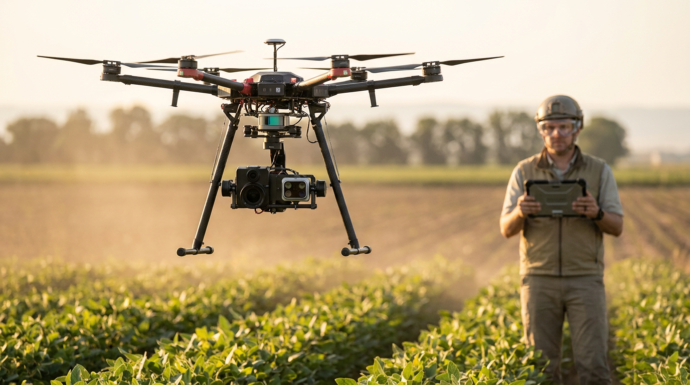
The primary claim driving this shift is that AI-powered aerial surveys can map suspected hazardous areas exponentially faster than human teams, drastically reducing the time required to declare land safe for civilian return. In Ukraine, which currently faces the largest global landmine challenge since World War II, this capability is moving rapidly from experimental trials to active deployment. Organizations like the HALO Trust and local tech developers are utilizing commercial off-the-shelf drones equipped with advanced sensor payloads to scan vast agricultural tracts safely from the air.[1][5]
The mechanism behind this AI detection relies heavily on multi-modal sensor fusion. Drones fly over suspected minefields carrying RGB optical cameras, infrared thermal sensors, and increasingly, miniaturized ground-penetrating radar. As the drone sweeps the area, it captures sub-centimeter-level imagery and thermal signatures of the terrain below. This massive influx of raw data is then fed directly into machine learning models that have been trained on hundreds of thousands of labeled images of various explosive devices, ranging from anti-personnel mines to cluster munitions.[5]

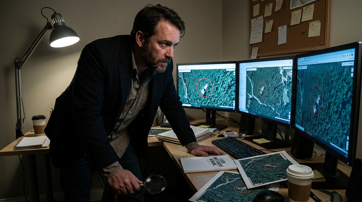
Once the data is processed, the software automatically detects, labels, and GPS-tags surface and near-surface threats, generating a comprehensive heat map of the danger zone within minutes of the drone landing. Developers report that a single AI-equipped drone can survey up to 10,000 square meters of territory in a single day. This rapid mapping provides actionable, high-fidelity intelligence to deminers, allowing them to bypass empty fields and focus their physical clearance efforts exclusively on confirmed hazardous zones.[5]
Crucially, the most significant value of AI mapping lies not just in finding mines, but in forensically proving their absence. Humanitarian organizations note that a major part of their work involves canceling suspected areas. When a community is displaced by conflict, they are understandably suspicious of returning to unverified land. By marrying satellite imagery, drone data, and AI analysis, demining teams can definitively demonstrate that specific agricultural fields are free of contamination, immediately returning that land to productive economic use.[1]
While artificial intelligence excels at identifying surface anomalies and metallic unexploded ordnance, a secondary technological breakthrough is addressing the persistent challenge of buried, low-metal, or plastic landmines. The claim emerging from defense research laboratories is that quantum magnetometry can detect the minute magnetic signatures of these elusive devices without requiring any physical contact with the ground. This offers a revolutionary new tool for subsurface detection, potentially rendering the camouflage of modern plastic explosives entirely ineffective against advanced quantum sweeps.[2][6]
Traditional metal detectors rely on actively generating a magnetic field to induce a response from buried metal. In contrast, quantum magnetometers operate passively. They scan for microscopic deviations in the Earth's natural magnetic field caused by the presence of magnetically alterable materials used in a mine's construction, such as tiny stainless steel firing pins or springs. Because the technique is entirely passive, it does not disturb the environment and cannot trigger smart mines designed to detonate upon detecting active electromagnetic sweeps.[2]
Traditional metal detectors rely on actively generating a magnetic field to induce a response from buried metal.
The underlying physics of this detection method involves measuring the behavior of atomic structures, such as nitrogen-vacancy centers in diamonds or quantum photonic states, when exposed to local magnetic anomalies. Recent field validations by quantum technology firms and military research centers have demonstrated the ability to detect unexploded ordnance at sub-surface depths of up to 30 inches. As these quantum sensors shrink from laboratory-sized arrays to drone-mountable payloads, they promise to provide a level of subterranean visibility previously considered impossible.[6]

The rapid transition of these advanced technologies from military laboratories to humanitarian fields is heavily supported by state-sponsored initiatives. The United States Department of Defense's Humanitarian Demining Research and Development Program plays a central role in this pipeline. By adapting existing commercial and tactical countermine technologies for civilian use, the program has provided vital equipment that has successfully cleared over 100 million square meters of contaminated land across 44 countries. This collaborative approach ensures that innovations born out of necessity on the battlefield are quickly repurposed to save civilian lives during peacetime.[3]
Despite these highly promising advancements, the evidence pack surrounding automated demining carries transparent uncertainties. The primary engineering challenge remains the false positive rate. Ground-penetrating radar and thermal imaging can struggle in highly mineralized soils, dense vegetation, or areas littered with non-lethal battlefield debris like shrapnel and shell casings. An AI model that flags every piece of buried scrap metal as a potential mine can inadvertently slow down the clearance process by forcing human teams to investigate harmless anomalies.[4][7]
Furthermore, quantum magnetometry, while highly sensitive, is still susceptible to environmental noise. Isolating the quantum sensor from the operational vibrations and electromagnetic interference generated by the drone itself requires complex shielding and pulsed control schemes. Moving these delicate systems from controlled test ranges to chaotic, real-world post-conflict environments remains a rigorous technical hurdle that engineers are actively working to overcome. Ensuring that these sensors can operate reliably in extreme weather conditions and rugged terrain is the next major milestone for developers.[2][7]

Because of these inherent limitations, the international demining community strictly adheres to a toolbox approach. The Geneva International Centre for Humanitarian Demining emphasizes that drones, artificial intelligence, and quantum sensors do not render traditional manual deminers obsolete. Instead, they augment human operators. The technology handles the macro-level surveying and risk reduction, but the final, delicate act of excavating and neutralizing the explosive still relies on the trained hands of human experts.[4]
The economic and human stakes of perfecting this technological synergy are immense. In regions heavily dependent on agriculture, uncleared land equates to lost harvests, inflated food prices, and prolonged reliance on international aid. By accelerating the land release process, advanced sensor technologies directly contribute to global food security, post-war economic stabilization, and the safe return of internally displaced populations. Every square meter of land verified as safe represents a tangible step toward rebuilding shattered communities and restoring local livelihoods.[1][7]
Looking forward, the trajectory of defense spin-offs in humanitarian mine action points toward fully integrated, autonomous clearance networks. As machine learning algorithms require less computing power and quantum sensors achieve commercial scalability, the vision of deploying swarms of intelligent, non-invasive detection drones becomes increasingly viable. While the scars of conflict run deep, the application of these cutting-edge tools offers a realistic pathway to eradicating the global backlog of unexploded ordnance within our lifetime.[7]
How we got here
1993
The U.S. Conventional Weapons Destruction program is established, beginning decades of funding for humanitarian mine action.
1996
The U.S. Department of Defense expands its humanitarian demining program to develop and share improved clearance technology globally.
2022
The escalation of the conflict in Ukraine creates the largest new landmine contamination challenge since World War II, spurring rapid technological innovation.
Late 2023
The Geneva International Centre for Humanitarian Demining highlights AI and drone image analysis as disruptive innovations at its global conference.
Mid 2025
Ukrainian developers successfully deploy AI-equipped drones capable of mapping 10,000 square meters of hazardous territory per day.
Early 2026
Quantum magnetometry sensors achieve successful field validations, detecting buried ordnance at depths up to 30 inches.
Viewpoints in depth
Humanitarian Demining Organizations
Prioritize safety, community trust, and the practical integration of new tools into existing workflows.
For organizations like the HALO Trust and the GICHD, technology is a means to an end, not a silver bullet. They argue that while AI and drones drastically reduce the time spent surveying empty land, the final clearance must always rely on human verification. Their primary concern is ensuring that new technologies do not introduce unacceptable risks through false negatives. They emphasize the 'toolbox approach,' where advanced sensors complement rather than replace the meticulous work of manual deminers, ensuring that land returned to communities is unequivocally safe.
Defense Technology Developers
Focus on pushing the boundaries of sensor capabilities, processing speed, and autonomous operation.
Tech developers and quantum research firms view the landmine crisis as a data and sensing problem that can be solved with enough computational power and physical precision. They highlight the exponential gains in efficiency—surveying 10,000 square meters a day compared to a few dozen meters by hand. Their focus is on refining machine learning models to reduce false positives and miniaturizing quantum magnetometers so they can be deployed on commercial drones, ultimately aiming for fully autonomous detection swarms.
Government & Military Sponsors
View demining technology as a critical component of post-conflict stabilization and international security.
State departments and military research branches approach humanitarian demining through the lens of global stability. By funding the adaptation of tactical countermine technology for civilian use, they aim to accelerate economic recovery in war-torn regions, thereby reducing the likelihood of renewed conflict. They argue that investing in these tech spin-offs is highly cost-effective, as clearing agricultural land restores food security and allows displaced populations to return, reducing the long-term burden on international humanitarian aid.
What we don't know
- How quickly quantum magnetometers can be miniaturized and ruggedized for widespread commercial drone deployment in harsh environments.
- Whether AI models can be trained to completely filter out the high volume of false positives caused by harmless battlefield debris.
- The exact timeline for when autonomous detection swarms will become affordable enough for underfunded demining operations in developing nations.
Key terms
- Unexploded Ordnance (UXO)
- Explosive weapons such as bombs, shells, grenades, and landmines that did not explode when they were employed and still pose a risk of detonation.
- Ground-Penetrating Radar (GPR)
- A geophysical method that uses radar pulses to image the subsurface, detecting buried objects or changes in material properties.
- Quantum Magnetometry
- A highly sensitive measurement technique that uses quantum mechanical effects, such as the behavior of atomic defects in diamonds, to detect minute variations in magnetic fields.
- Sensor Fusion
- The process of combining data from multiple different types of sensors, such as optical, thermal, and radar, to create a more accurate and comprehensive model of an environment.
- Non-Technical Survey (NTS)
- The process of collecting and analyzing data about a suspected hazardous area without physically entering the minefield, often using drones and historical records.
Frequently asked
Can AI drones physically remove the landmines?
No. Drones and AI are used exclusively for detection and mapping. The physical excavation and neutralization of the explosives are still performed by trained human professionals or specialized armored machines.
How does a quantum magnetometer differ from a regular metal detector?
A traditional metal detector actively emits a magnetic field to find metal, which can trigger certain sensitive mines. A quantum magnetometer is entirely passive, measuring microscopic disruptions in the Earth's natural magnetic field caused by the mine's components.
Why is ground-penetrating radar not a perfect solution?
Ground-penetrating radar can struggle in highly mineralized soils, dense vegetation, or areas with high moisture content. It can also generate false positives by detecting harmless buried objects like rocks or battlefield debris.
How much land has the U.S. DoD program helped clear?
By adapting commercial and military technologies for humanitarian use, the U.S. Department of Defense's research program has facilitated the clearance of over 100 million square meters of land globally.
Sources
Source coverage
7 outlets
4 viewpoints surfaced


[1]National Defense MagazineHumanitarian Demining Organizations
Ukraine War Spurs Demining Tech Advancements
Read on National Defense Magazine →[2]Australian Army Research CentreGovernment & Military Sponsors
Detecting Landmines with Magnetometers
Read on Australian Army Research Centre →[3]U.S. Department of StateGovernment & Military Sponsors
Saving Lives and Taxpayer Dollars by Adapting Off-the-Shelf Technology for Humanitarian Demining
Read on U.S. Department of State →[4]GICHDHumanitarian Demining Organizations
Innovation in Humanitarian Demining
Read on GICHD →[5]TechUkraineDefense Technology Developers
Ukraine Develops AI Drone for Mine Detection
Read on TechUkraine →[6]Quantum Computing Inc.Defense Technology Developers
Quantum sensors could find landmines, chip defects, much more
Read on Quantum Computing Inc. →[7]Factlen Editorial TeamIndependent Analysts
Synthesis by Factlen editorial team
Read on Factlen Editorial Team →
Every angle. Every day.
Get defense security stories with full source coverage and perspective breakdowns delivered to your inbox.