How AI and Sensor Networks Are Beating 911 Calls to Stop Wildfires
Networks of AI-powered cameras, satellites, and solar-powered gas sensors are detecting wildfires minutes after ignition, giving first responders a critical head start.
By Factlen Editorial Team
- Public Safety Agencies
- Focus on rapid response, resource allocation, and beating 911 calls.
- Technology Developers
- Focus on sensor fusion, machine learning accuracy, and scaling the technology.
- Environmental Scientists
- Focus on predictive modeling, smoke pollution, and climate-era adaptation.
What's not represented
- · Rural residents in high-risk zones
- · On-the-ground wildland firefighters
Why this matters
Early detection is the difference between a small brush fire and a catastrophic megafire. By spotting smoke before humans do, these systems are saving thousands of acres, protecting communities, and reducing the massive economic and environmental toll of wildfires.
Key points
- Artificial intelligence is shifting wildfire management from reactive 911 calls to proactive early detection.
- Networks of high-definition cameras perform continuous 360-degree sweeps, using machine learning to spot smoke.
- Human analysts verify AI alerts to prevent false positives from fog or dust.
- Solar-powered gas sensors are being deployed to detect the smoldering phase of fires before smoke is visible.
- Predictive AI models are now forecasting fire spread and smoke pollution to aid in early evacuations.
For decades, the first line of defense against a catastrophic wildfire was a combination of luck and human vigilance. A hiker spotting a distant plume of smoke, a passing motorist dialing 911 from a highway, or a dedicated lookout tower observer scanning the horizon through binoculars. But in the climate era, where prolonged droughts desiccate landscapes and fires grow with unprecedented speed, waiting for a human to notice a blaze is no longer a viable strategy. The critical window between a spark's ignition and an uncontrollable inferno has shrunk to mere minutes. Once a fire establishes itself in dense, dry fuels, it can quickly overwhelm initial attack crews, leading to massive environmental destruction and economic loss.[2][8]
To reclaim that lost time, emergency management agencies and technology companies are deploying a vast, silent network of artificial intelligence. Across the drought-stricken American West, Australia, and parts of Europe, AI-enabled cameras, solar-powered gas sensors, and satellite data feeds are constantly monitoring high-risk, sparsely populated areas. These systems are designed to do one thing: detect the earliest signs of combustion and alert first responders long before a human ever dials for help. By shifting the paradigm from reactive human reporting to proactive machine monitoring, these technologies are fundamentally altering how society defends against one of nature's most destructive forces.[3][4]
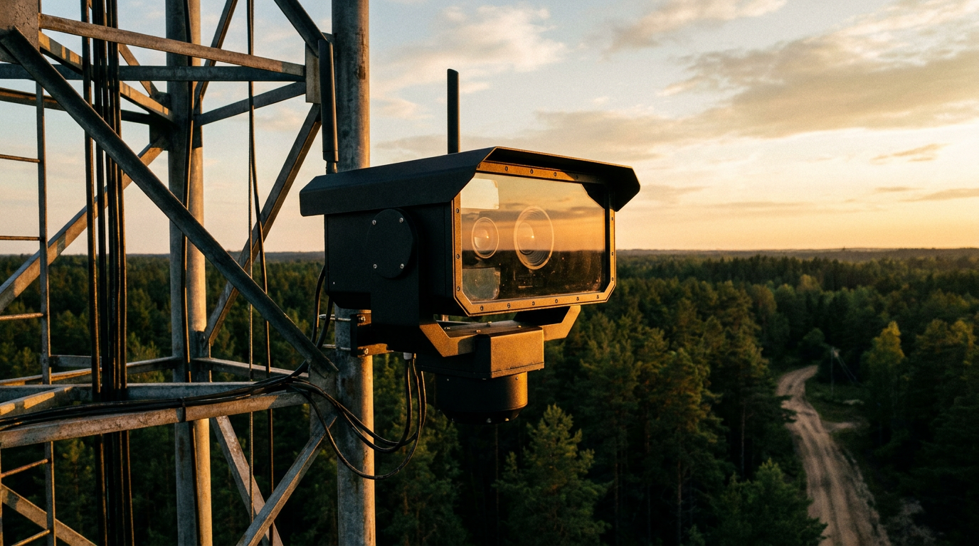
The vanguard of this technological shift is ALERTCalifornia, a massive public-private partnership based at the University of California, San Diego. The program operates a network of more than 1,240 high-definition, pan-tilt-zoom cameras strategically positioned across the state, from the dense northern redwood forests to the arid southern border with Mexico. These cameras perform continuous 360-degree sweeps every two minutes, capturing high-resolution visual data of the landscape. Many of these units are equipped with near-infrared night vision capabilities, allowing them to pierce through darkness and monitor remote wilderness areas 24 hours a day, seven days a week.[2][5]
The sheer volume of visual data generated by over a thousand rotating cameras is impossible for human operators to monitor effectively. This is where artificial intelligence steps in to do the heavy lifting. Advanced machine learning algorithms continuously analyze the live video feeds, scanning pixel by pixel for the visual signatures of smoke. Crucially, the AI is trained on millions of images to differentiate between a genuine fire and non-threatening environmental anomalies. It can distinguish a nascent wildfire from low-hanging fog, dust kicked up by a tractor, or geothermal steam, ensuring that the system only flags legitimate threats.[2][7]

When the algorithm detects a potential fire, it does not automatically dispatch fire trucks or sound public alarms. Instead, it relies on a strict 'human-in-the-loop' verification system to prevent costly false alarms. The AI flags the visual anomaly and immediately alerts a human analyst at an emergency command center. The analyst reviews the high-definition footage, confirms the presence of a fire, and then notifies local fire agencies. This combination of tireless machine vigilance and nuanced human judgment keeps the rate of false positives remarkably low while maintaining lightning-fast response times.[2][6]
The real-world results of this rapid detection are tangible and life-saving. In 2025 alone, the ALERTCalifornia system detected 915 fires before any member of the public reported them to authorities. In remote, rugged terrain where human presence is sparse, AI technology can notify authorities an average of 45 minutes faster than the first 911 call. That crucial head start allows agencies to launch emergency personnel, bulldozers, and water-dropping aircraft while the fire is still small enough to contain, often extinguishing the blaze before nearby residents are even aware it existed.[1][3]
The success of academic and state-run programs has catalyzed a booming commercial sector dedicated to wildfire intelligence. Companies like San Francisco-based Pano AI are rapidly scaling similar technologies for a variety of clients. Pano mounts its high-definition, rotating cameras on existing infrastructure, such as commercial cell towers and utility mountaintops. By 2026, the company's network was monitoring 50 million acres across 17 U.S. states, as well as regions in Canada and Australia, providing subscription-based early detection intelligence to private forestry operations, utility companies, and local county governments.[2][3][7]
The success of academic and state-run programs has catalyzed a booming commercial sector dedicated to wildfire intelligence.
However, optical camera detection is only one piece of the puzzle. In dense, old-growth forests, a fire can smolder on the forest floor for hours before its smoke breaches the thick canopy and becomes visible to a mountaintop camera miles away. To catch these hidden ignitions, companies like Dryad Networks are deploying solar-powered gas sensors directly into the forest ecosystem. Attached to tree trunks about three meters off the ground, these sensors act as an electronic nose for the forest, constantly sniffing the air for the chemical byproducts of combustion.[4]

Dryad's sensors are highly calibrated to detect minute changes in air composition, specifically the unique blend of gases released during the initial smoldering phase of a fire. Each sensor monitors an area roughly the size of a football field, creating a dense mesh network of protection. Like the camera networks, these sensors utilize machine learning—trained on vast datasets acquired from controlled burns of various forest materials—to distinguish between a genuine fire and benign gas emissions. Because they store their energy in capacitors rather than lithium-ion batteries, the sensors themselves pose absolutely no fire risk to the environment they protect.[4]
The true power of modern wildfire defense lies in sensor fusion—the integration of multiple distinct data streams into a single, cohesive intelligence platform. Advanced command centers now ingest data from ground-based optical cameras, atmospheric gas sensors, and orbital satellites simultaneously. This multi-layered approach ensures comprehensive coverage: if a fire is obscured from a camera by a steep ridgeline, a satellite might catch its thermal signature from space, or a nearby gas sensor might detect its emissions through the canopy.[2][8]
Beyond mere detection, artificial intelligence is increasingly being used for predictive modeling during active incidents. At George Mason University, researchers are collaborating with NASA's Jet Propulsion Laboratory to create systems that forecast exactly where a newly detected fire will spread. By analyzing real-time topography, localized wind patterns, and the moisture content of surrounding vegetation, these advanced models can project a fire's path with unprecedented accuracy, giving incident commanders a digital crystal ball.[2]

This predictive capability extends to the secondary, yet highly lethal, threat of wildfires: widespread smoke pollution. Wildfire smoke contains fine particulate matter that can cause severe respiratory distress, often affecting populations hundreds of miles away from the actual flames. AI models are now being trained to forecast exactly which communities will be hardest hit by hazardous air quality as the wind shifts. This allows public health officials and emergency managers to issue targeted early warnings, close schools, and initiate evacuations for vulnerable populations long before the sky turns orange and the air becomes unbreathable.[2]
Despite these massive technological leaps, seasoned fire experts caution that AI is an augmentation, not a replacement, for traditional firefighting personnel. Algorithms cannot dig fire lines, drop chemical retardant, or make complex tactical decisions on the chaotic fire ground. As fire behavior shifts unpredictably in extreme winds, the human factor remains the ultimate arbiter of how a blaze is fought. The technology exists to provide real-time information so that human commanders can make better, faster, and safer decisions.[2]
Furthermore, the technology is not infallible and comes with inherent physical limitations. Heavy cloud cover, intense rain, or thick smoke from existing fires can blind optical cameras, while extreme winter weather can damage remote sensors. The systems require continuous, expensive maintenance, robust communication networks to transmit high-definition data from deep wilderness areas, and ongoing algorithmic training to adapt to changing environmental conditions. A camera is only useful if its data can reach the command center without interruption.[7]

Nevertheless, the integration of artificial intelligence into wildfire management represents a fundamental shift from a reactive posture to a proactive one. As the technology matures and becomes more deeply integrated into public safety infrastructure, the lines between 'AI wildfire detection' and standard emergency response will blur, making these systems as ubiquitous and essential as the fire engine itself. While technology cannot prevent every lightning strike or careless spark, it is proving that we no longer have to wait for the smoke to clear to take decisive action.[1][2]
How we got here
2020
Commercial startups like Pano AI launch to bring AI-powered camera networks to the private sector.
2021
Early pilot programs in California and Colorado demonstrate AI's ability to spot fires before human observers.
2023
Dryad Networks begins scaling its solar-powered gas sensors to detect the smoldering phase of forest fires.
2025
ALERTCalifornia reports its AI network detected over 900 fires before any 911 calls were made.
Viewpoints in depth
Public Safety Agencies
Emergency managers prioritize rapid response and resource allocation.
For organizations like CAL FIRE and local emergency management offices, the primary value of AI is operational speed. Their focus is on the critical window between ignition and containment. By receiving verified alerts minutes before a 911 call, they can dispatch aircraft and ground crews while the fire is still manageable. These agencies emphasize that AI does not replace human firefighters, but rather serves as an advanced intelligence tool that allows them to deploy limited resources more effectively and safely.
Technology Developers
Companies and researchers focus on sensor fusion and algorithmic accuracy.
The engineers and data scientists building these systems—from university researchers to commercial startups like Pano AI and Dryad Networks—are focused on the technical challenges of scale and precision. They argue that the future of disaster response lies in 'sensor fusion,' combining optical cameras, gas sensors, and satellite imagery into a single pane of glass. Their primary concern is continuously training machine learning models to reduce false positives caused by fog or dust, ensuring that command centers are not overwhelmed by inaccurate alerts.
Environmental Scientists
Researchers focus on predictive modeling and the broader climate context.
Climatologists and environmental researchers view AI detection as a necessary adaptation to the 'climate era,' where prolonged droughts and extreme heat make fires inevitably larger and faster. Their focus extends beyond immediate detection to predictive modeling—using AI to forecast fire behavior, smoke trajectories, and ecological impacts. They argue that while early detection is crucial, it must be paired with long-term forest management and climate mitigation strategies, as technology alone cannot solve the underlying environmental conditions driving megafires.
What we don't know
- How effectively these AI models will adapt to entirely new fire behaviors caused by unprecedented climate extremes.
- The long-term funding models for maintaining and upgrading these massive sensor networks across vast rural areas.
Key terms
- Sensor Fusion
- The process of combining data from multiple different types of sensors (like cameras, satellites, and gas detectors) to create a more accurate and comprehensive understanding of an event.
- Pan-Tilt-Zoom (PTZ) Camera
- A specialized camera that can be remotely controlled to rotate horizontally, tilt vertically, and zoom in closely on distant objects.
- Human-in-the-Loop
- A system design where artificial intelligence performs the initial analysis, but a human operator must review and approve the final decision before action is taken.
- Smoldering Phase
- The early, slow-burning stage of a fire before it erupts into open flames, often producing specific gases but very little visible smoke.
Frequently asked
Can AI put out the wildfire?
No. AI systems are strictly used for early detection and predictive modeling. Human firefighters and aircraft are still required to actually extinguish the blaze.
What happens if the AI makes a mistake?
To prevent false alarms, these systems use a 'human-in-the-loop' approach. If the AI flags a cloud of dust as smoke, a human analyst reviews the footage and dismisses the alert before any fire trucks are dispatched.
How do the cameras see at night?
Many of the high-definition cameras are equipped with near-infrared night vision technology, allowing them to detect the thermal signatures of fires even in complete darkness.
Are these systems only used in California?
While California has the largest public network, AI wildfire detection is currently deployed across 17 U.S. states, as well as in Canada, Australia, and parts of Europe.
Sources
Source coverage
8 outlets
3 viewpoints surfaced


[1]Factlen Editorial TeamEnvironmental Scientists
Synthesis by Factlen editorial team
Read on Factlen Editorial Team →[2]Associated PressPublic Safety Agencies
States across the wildfire-prone Western US are using AI for early detection
Read on Associated Press →[3]WBURPublic Safety Agencies
AI is watching for wildfires across the drought-stricken West
Read on WBUR →[4]CNETTechnology Developers
Using Solar-Powered AI Sensors to Detect Wildfires Earlier
Read on CNET →[5]ALERTCaliforniaTechnology Developers
Research & Technology: Artificial Intelligence
Read on ALERTCalifornia →[6]Pano AITechnology Developers
Advanced Wildfire + Bushfire Detection Technology
Read on Pano AI →[7]GovTechPublic Safety Agencies
Big Sky, Big Data: Mont. Area Pilots AI for Wildfire Defense
Read on GovTech →[8]exciEnvironmental Scientists
AI Innovation in Response to Escalating Wildfire Crisis
Read on exci →
Every angle. Every day.
Get environment stories with full source coverage and perspective breakdowns delivered to your inbox.