How AI and Satellite Networks Are Predicting and Spotting Wildfires Before They Spread
Artificial intelligence is revolutionizing wildfire management by using vast camera networks and satellite data to detect smoke before 911 calls are made. By shifting from reactive responses to predictive modeling, these systems are helping agencies contain blazes while they are still manageable.
By Factlen Editorial Team
- Fire Management Agencies
- Prioritize early detection and rapid resource deployment to contain blazes before they expand.
- AI & Climate Researchers
- Focus on integrating disparate datasets to improve the predictive accuracy of fire behavior models.
- Utility Companies
- Emphasize infrastructure protection and liability mitigation by monitoring high-risk transmission corridors.
What's not represented
- · Rural Residents in Fire Zones
- · Environmental Conservationists
- · Insurance Industry Underwriters
Why this matters
As climate change lengthens fire seasons and supercharges infernos, traditional reactive firefighting is no longer enough. AI detection systems are buying first responders the most critical resource—time—allowing them to extinguish blazes before they destroy communities and ecosystems.
Key points
- AI-enabled camera networks are detecting wildfires an average of 45 minutes faster than traditional 911 calls.
- Computer vision algorithms analyze millions of images daily, identifying the visual signatures of smoke in remote areas.
- Predictive models now incorporate fuel moisture and ignition sources, forecasting fire probability days before a spark occurs.
- Satellite constellations process thermal data on the edge, spotting anomalies as small as five square meters from orbit.
- Human analysts remain essential to verify AI detections, ensuring resources are not wasted on false alarms like dust or clouds.
For decades, the first line of defense against a wildland fire was a human being. A hiker smelling smoke on a remote trail, a driver spotting an ominous orange glow on the horizon, or a resident calling 911 as flames crested a nearby ridge. By the time those calls reached emergency dispatchers, the fire had often already established a dangerous foothold, feeding on dry brush and accelerating beyond the capacity of initial attack crews. In an era where climate change has steadily lengthened fire seasons and supercharged infernos, that reactive delay has become increasingly catastrophic. Modern megafires can consume tens of thousands of acres in a single afternoon, creating their own weather systems and rendering traditional firefighting tactics obsolete. The window to stop these blazes is measured in minutes, not hours, making early detection the single most critical factor in preventing a localized spark from becoming a regional disaster.[7]
To close that gap, fire agencies and climate researchers have turned to artificial intelligence, fundamentally rewiring how humanity detects and responds to natural disasters. Across the American West, Europe, and Australia, vast networks of AI-enabled cameras, atmospheric sensors, and orbital satellites are now standing watch. These systems do not sleep, they do not blink, and they can process visual data at a scale that would require thousands of human analysts. The result is a paradigm shift in emergency management: moving from a posture of waiting for the fire to come, to actively hunting for its earliest signatures.[3][4]
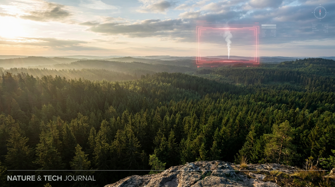
The vanguard of this technological shift is ALERTCalifornia, a public safety program based at the University of California, San Diego. The initiative has blanketed the state with more than 1,240 high-definition, pan-tilt-zoom cameras, strategically positioned on mountaintops, fire towers, and communication arrays. These cameras feed millions of images daily into a sophisticated computer vision algorithm trained to recognize the faint, wispy visual signature of nascent smoke. When the artificial intelligence detects an anomaly, it immediately flags the feed for human review, highlighting the suspected smoke plume with a bright red bounding box. The system also calculates a certainty estimate and provides precise geographic coordinates, allowing dispatchers to instantly cross-reference the location with topographic maps and weather data to determine the potential threat level.[1][3]
The operational impact of this machine-speed detection is profound. In many rural and remote areas, where population density is too low to rely on civilian reporting, the AI has become the primary sentinel. According to system operators, the algorithms are now routinely beating traditional 911 calls, alerting command centers to new ignitions an average of 45 minutes faster than human observers. That head start is the difference between dispatching a single helicopter to drop water on a quarter-acre brush fire, and mobilizing a multi-agency task force to battle a raging firestorm.[3][4]

A textbook example of this advantage occurred during the Diamond Fire in Arizona's Coconino National Forest. On a dry, wind-swept afternoon, an AI detection system flagged a subtle visual disturbance on a camera feed trained on a remote stretch of timber. Within moments, human reviewers confirmed it was smoke—not a dust devil or a low-hanging cloud—and immediately alerted the Arizona Department of Forestry and Fire Management, as well as the local electric utility. Because the notification arrived so early, crews were able to launch aircraft and deploy ground personnel before the fire could crown into the forest canopy, ultimately holding the blaze to just seven acres. Without the AI acting as a digital lookout, the fire could have burned unnoticed for hours in the rugged terrain, requiring millions of dollars in suppression efforts.[3][4]
But early detection is only half of the technological equation; the holy grail of wildfire management is prediction. Knowing that a fire has started is vital, but knowing exactly where it will go—and how fast—allows commanders to issue precise evacuation orders and position resources ahead of the flame front. Historically, fire forecasting relied on physics-based models like the Fire Weather Index, which calculated danger based on temperature, wind, humidity, and precipitation. While useful, these traditional models were computationally heavy, slow to update, and lacked granular data on the actual fuel available to burn.[2][7]
But early detection is only half of the technological equation; the holy grail of wildfire management is prediction.
Machine learning is now bridging that gap by ingesting massive, disparate datasets that traditional models could not handle. At the European Centre for Medium-Range Weather Forecasts (ECMWF), scientists have developed a new Probability of Fire model that uses AI to analyze not just weather, but vegetation dryness, land cover, and human ignition sources like road access and population density. By synthesizing these variables, the ECMWF model can predict the likelihood of a fire igniting in a highly specific location days in advance, rather than just issuing a broad regional warning.[2]

Once a fire is actively burning, dynamic spread modeling takes over to guide the tactical response. The WIFIRE Lab at UC San Diego has pioneered an AI-powered platform that recalculates a fire's probable path in real time, adapting to shifting winds and terrain. The system continuously ingests live weather station data, geospatial terrain maps, and infrared imagery captured by drones flying above the smoke canopy. Using recurrent neural networks, it learns how fires have historically behaved under identical micro-conditions. During the 2020 Valley Fire, this platform provided updated spread forecasts every fifteen minutes. As wind conditions shifted, the AI instantly visualized the new threat vectors, allowing emergency operations centers to preemptively issue evacuation warnings and stage fire crews effectively, preventing resource overlap and keeping firefighters out of deadly trap zones.[5][7]
The view from space is also receiving a massive AI upgrade. While ground-based cameras are highly effective, their line of sight is limited by topography and Earth's curvature. To achieve true global coverage, initiatives like FireSat are deploying constellations of AI-enabled satellites equipped with advanced thermal sensors. These orbital platforms process imagery on the edge—meaning the AI runs directly on the satellite—allowing them to detect thermal anomalies as small as five square meters. Instead of waiting for a satellite to complete an orbit and beam raw data to Earth for processing, the system can transmit an alert in less than 20 minutes.[6]
Powering this global surveillance network requires immense computational infrastructure. Training the deep learning models to accurately distinguish smoke from morning fog, or a wildfire from an industrial smokestack, involves processing petabytes of historical data. Technology partners and government agencies are utilizing high-performance graphics processing units (GPUs) and tensor processing units (TPUs) to handle the parallel processing required. Every time the system makes a detection—and every time a human analyst corrects a false positive—that data is fed back into the neural network, continuously refining its accuracy for the next fire season.[7]

Despite these remarkable advancements, developers and fire officials are quick to emphasize that AI is a tool to augment human judgment, not replace it. The systems are not error-proof. Glare from the setting sun, agricultural dust kicked up by tractors, and low-altitude clouds can still trigger false alerts. This is why a "human-in-the-loop" architecture remains mandatory. Analysts must verify the AI's flags before any resources are committed, ensuring that fire departments do not waste precious time and fuel chasing digital ghosts.[1][4]
Furthermore, AI detection offers diminishing returns in highly developed wildland-urban interfaces. In densely populated suburbs, residents will almost always spot and report a fire faster than a camera network can process the imagery. The technology also provides little tactical advantage during extreme, wind-driven events, where hurricane-force gusts can drive embers miles ahead of the main fire line, creating unpredictable spot fires that overwhelm any predictive model. In those chaotic scenarios, the raw physics of the fire simply outpaces the ability to safely position crews, and the focus must shift entirely to life safety and rapid evacuation rather than containment.[4]
Recognizing these limitations, the focus remains on expanding coverage in the vast, unpopulated corridors where fires historically gain their momentum. The success of the California network has spawned ALERTWest, an initiative aiming to replicate the camera and AI infrastructure across other fire-prone states. Utility companies, which face immense liability if their equipment sparks a blaze, are also aggressively deploying their own AI camera networks to monitor high-risk transmission lines, hoping to catch ignitions before they threaten communities.[1][3]

As global temperatures continue to rise and landscapes dry out, the threat of catastrophic wildfires will inevitably grow. Artificial intelligence cannot thin overgrown forests, nor can it lower the ambient temperature of a warming planet. What it can do is buy humanity time. By transforming the critical first hour of a wildfire from a period of confusion into a window of precise, data-driven action, AI is giving first responders a fighting chance to keep small fires small, protecting ecosystems and saving lives in the process.[6][8]
How we got here
2020
UC San Diego's WIFIRE Lab successfully uses AI to dynamically model the spread of the Valley Fire, aiding evacuation efforts.
2023
DigitalPath's AI begins operating across CAL FIRE command centers, processing millions of images daily.
2024
Researchers introduce generative AI models combined with satellite data to accurately forecast wildfire spread rates.
2025
The European Centre for Medium-Range Weather Forecasts launches a machine-learning model to predict global fire probability.
2026
AI camera networks expand across the American West, consistently beating traditional 911 calls in reporting new ignitions.
Viewpoints in depth
Fire Management Agencies
Prioritize early detection and rapid resource deployment to contain blazes before they expand.
For state and federal fire agencies, the primary value of AI lies in tactical speed. Organizations like CAL FIRE and the Arizona Department of Forestry view the technology as a force multiplier that allows them to aggressively attack fires during their most vulnerable infancy. Their focus is on reducing response times, optimizing the staging of aircraft and ground crews, and preventing the massive economic and ecological costs associated with prolonged megafires.
AI & Climate Researchers
Focus on integrating disparate datasets to improve the predictive accuracy of fire behavior models.
Academic institutions and meteorological centers are focused on the data science behind the flames. Researchers argue that while early detection is crucial, the ultimate goal is perfect prediction. By continuously feeding neural networks with real-time weather, topography, and fuel moisture data, they aim to create dynamic models that can forecast a fire's exact path and intensity hours in advance, fundamentally shifting emergency management from a reactive discipline to a predictive science.
Utility Companies
Emphasize infrastructure protection and liability mitigation by monitoring high-risk transmission corridors.
For major electric utilities, AI detection is both a public safety tool and a critical liability shield. Following devastating fires sparked by downed power lines, companies are investing heavily in their own camera networks to monitor remote infrastructure. Their objective is to immediately detect any anomalies near their equipment, allowing them to de-energize lines or dispatch private fire crews before a spark can evolve into a catastrophic, multi-billion-dollar legal and public relations disaster.
What we don't know
- How effectively AI spread models will perform during unprecedented, climate-driven megafires that create their own localized weather systems.
- Whether the high costs of deploying and maintaining dense camera networks can be sustained by smaller, underfunded rural fire districts.
- How the integration of AI will alter the legal liability of utility companies if a system fails to detect a spark from their equipment.
Key terms
- Computer Vision
- A field of artificial intelligence that enables computers to derive meaningful information from digital images and videos.
- Fire Weather Index
- A traditional, physics-based metric that estimates fire danger based solely on temperature, wind, humidity, and precipitation.
- Fuel Load
- The amount of flammable material, such as dry grass, fallen leaves, and dead trees, available in a specific area to feed a wildfire.
- Wildland-Urban Interface
- Areas where human development meets or intermingles with undeveloped natural land, creating high-risk zones for destructive wildfires.
Frequently asked
Can AI predict exactly where a wildfire will start?
While it cannot pinpoint a single spark, AI models evaluate fuel moisture, weather, and historical data to map high-probability ignition zones days in advance.
Does AI automatically dispatch fire trucks?
No. AI systems flag anomalies and provide spread predictions, but human analysts and fire commanders still make the final decisions on resource deployment.
How does AI tell the difference between smoke and a cloud?
Computer vision algorithms are trained on millions of images, learning the specific visual signatures, movement patterns, and light scattering properties of smoke versus dust, fog, or clouds.
Sources
Source coverage
8 outlets
3 viewpoints surfaced


[1]ALERTCaliforniaAI & Climate Researchers
ALERTCalifornia: Advanced Technology for Wildfire Resiliency
Read on ALERTCalifornia →[2]European Centre for Medium-Range Weather ForecastsAI & Climate Researchers
Machine learning for fire probability forecasting
Read on European Centre for Medium-Range Weather Forecasts →[3]FireRescue1Fire Management Agencies
Utilities, fire agencies deploy AI cameras to spot wildfires early
Read on FireRescue1 →[4]BetaNewsFire Management Agencies
How AI is outpacing 911 calls for wildfire detection
Read on BetaNews →[5]WIFIRE LabAI & Climate Researchers
Dynamic Data-Driven Wildfire Modeling
Read on WIFIRE Lab →[6]Lombard OdierUtility Companies
How AI and machine learning are revolutionising wildfire management
Read on Lombard Odier →[7]Onyx Government ServicesUtility Companies
How AI Helped Predict Wildfire Paths in California
Read on Onyx Government Services →[8]Factlen Editorial TeamAI & Climate Researchers
Synthesis by Factlen editorial team
Read on Factlen Editorial Team →
Every angle. Every day.
Get environment stories with full source coverage and perspective breakdowns delivered to your inbox.