How AI and Multi-Sensor Drones Are Revolutionizing Humanitarian Demining
Autonomous drones equipped with multi-modal sensors and deep learning algorithms are mapping unexploded ordnance with unprecedented accuracy, making post-conflict recovery faster and significantly safer.
By Factlen Editorial Team
- Humanitarian Deminers
- Focus on operator safety, cost-effectiveness, and the reality that AI is an assistive tool rather than a complete replacement for human sappers.
- Defense Tech Innovators
- Emphasize the rapid deployment of autonomous systems, sensor fusion, and venture-backed scaling to solve the crisis faster.
- Academic Researchers
- Highlight the need for standardized benchmarks, open-source training data, and rigorous peer review to validate algorithmic accuracy.
What's not represented
- · Local civilian populations living in contaminated zones
- · Traditional manual clearance sappers
Why this matters
Unexploded ordnance paralyzes agricultural economies and claims thousands of civilian lives long after conflicts end. The shift from slow, dangerous manual clearance to AI-driven aerial mapping is accelerating the return of safe land to affected communities worldwide.
Key points
- Over 60 countries are contaminated by unexploded ordnance, a problem historically tackled by slow and dangerous manual clearance.
- Autonomous drones are now using multi-sensor fusion (thermal, LiDAR, radar) to map minefields from the air.
- Deep learning models process this data to identify buried explosives, achieving up to 97% accuracy in controlled academic trials.
- The Ukrainian Spiner UAV recently became the first quadcopter to receive official NATO codification for ground mine detection.
- Open-source data initiatives have published over 34 datasets, democratizing the development of life-saving demining algorithms.
- Experts stress that AI is an assistive risk-mapping tool, not a complete replacement for human sappers.
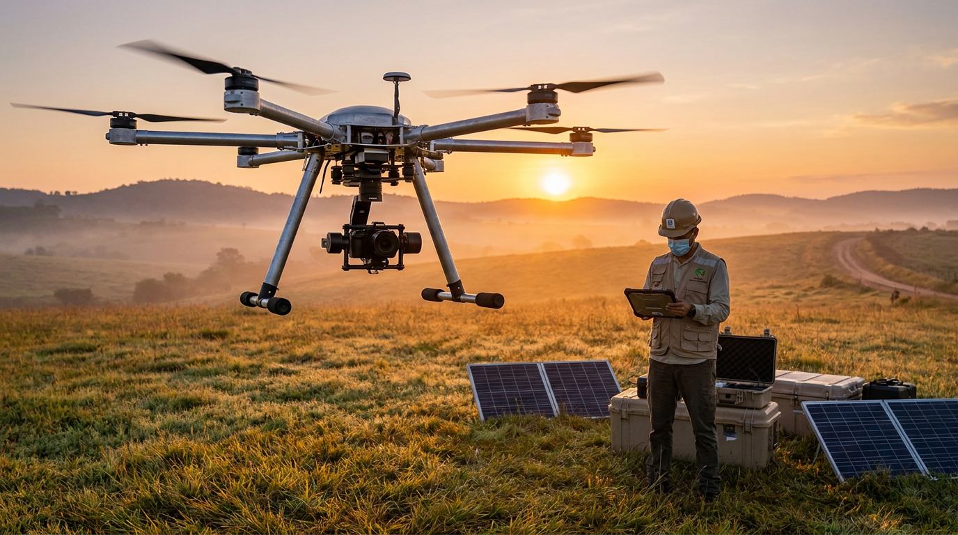
More than 60 countries worldwide remain contaminated by unexploded ordnance (UXO) and landmines, a lethal legacy of conflict that continues to claim thousands of civilian lives annually. For decades, the protocols for clearing these explosive remnants of war have relied heavily on twentieth-century methodologies. Human sappers, equipped with handheld metal detectors and probing rods, meticulously crawl through hazardous terrain, a process that is agonizingly slow, prohibitively expensive, and inherently dangerous. The sheer scale of global contamination has long outpaced the capacity of manual clearance teams, leaving vast tracts of agricultural land unusable and communities paralyzed by the hidden threat beneath their feet.[7]
However, a paradigm shift is currently underway in the field of humanitarian demining, driven by the convergence of commercial unmanned aerial vehicles (UAVs) and advanced artificial intelligence. Rather than sending humans into unknown minefields, clearance organizations and defense technology startups are deploying autonomous drones to map and analyze the terrain from above. This aerial reconnaissance layer fundamentally changes the risk equation, providing demining teams with high-resolution, color-coded risk maps before a single human boot touches the soil. By treating mine detection as a massive data-processing challenge, the industry is moving toward a future where clearance operations are exponentially faster and significantly safer.[7]
The foundation of this new approach lies in multi-sensor fusion. A 2025 systematic review of UAV remote sensing for UXO detection analyzed nearly a hundred recent deployments, revealing that no single detection method is universally effective. Ground-penetrating radar and magnetometry remain the most prevalent tools, but they are increasingly being combined with visible-light, multispectral, and thermal imaging. By integrating multiple sensor modalities onto a single multi-rotor platform, operators can compensate for the physical limitations of any individual technology, creating a comprehensive digital twin of the suspected hazard area.[3]

This multi-layered hardware approach recently achieved a major validation milestone. In late 2025, the Ukrainian defense developer Ailand Systems received an official NATO codification for its Spiner UAV, marking the first time a quadcopter has been formally codified by the alliance specifically for the detection of ground mines. Designed explicitly for humanitarian demining, the Spiner drone has already passed rigorous defense ministry testing and is actively being used to locate unexploded ordnance in active recovery zones. The codification signals that UAV-based detection has matured from experimental research into vetted, standardized operational doctrine.[2]
The technical specifications of the Spiner UAV illustrate the sophistication of modern aerial detection. The drone is equipped with a dual metal-detector search coil capable of identifying low-metal-content explosives, such as the widely deployed PMN-2 anti-personnel mine, at depths of up to 15 centimeters. As the drone autonomously navigates at low altitudes, it utilizes an algorithm that combines rotational and translational movements to scan strips of land up to 1.5 meters wide in a single pass. Crucially, the system checks each section of ground from multiple angles, reducing electromagnetic interference and dramatically increasing detection sensitivity compared to a human operator sweeping a handheld wand.[2]
While the hardware captures the raw environmental data, the true breakthrough lies in the software layer. Modern drones generate terabytes of multispectral and geophysical data per flight, a volume far too massive for human analysts to review manually. To bridge this gap, developers are employing deep learning convolutional neural networks (CNNs) to automatically identify the subtle visual, thermal, and magnetic signatures of buried explosives. These AI models are trained to recognize the specific ways that the ground around a buried landmine heats and cools differently than the surrounding undisturbed soil, a thermodynamic anomaly that is invisible to the naked eye but glaringly obvious to a trained neural network.[7]
Academic research has demonstrated the staggering potential of these algorithms in controlled environments. Studies utilizing fine-tuned object detection models, such as YOLOv5, applied to thermal imaging data collected by low-flying UAVs have achieved remarkable success rates. In several recent peer-reviewed trials, deep learning approaches successfully identified surface and near-surface explosive remnants with detection probabilities exceeding 90 percent. When integrated across multiple sensor inputs, some experimental frameworks have reported detection accuracy rates surpassing 97 percent, hinting at a future where algorithmic oversight could virtually eliminate the risk of missed ordnance.[3][5]

Academic research has demonstrated the staggering potential of these algorithms in controlled environments.
Translating those academic benchmarks into chaotic, real-world post-conflict zones remains a complex challenge, but commercial operators are rapidly closing the gap. Dropla Tech, a defense startup that recently secured €2.4 million to scale its AI-powered demining systems, utilizes a proprietary dataset of over one million images to train its models. Their drones, equipped with five distinct sensors, feed data into an AI system that categorizes terrain into safe and high-risk zones with an operational accuracy of approximately 80 percent. As the system processes more field data and receives direct feedback from clearance teams, its predictive accuracy continues to climb.[1]
The primary bottleneck preventing even higher accuracy has historically been a lack of high-quality, publicly available training data. Machine learning models require vast repositories of annotated examples to learn the diverse signatures of different munitions across varying soil types, weather conditions, and vegetation densities. For years, the data collected by military and private clearance organizations remained siloed, forcing new researchers to build their datasets from scratch. This data drought severely stunted the development of open-source demining algorithms and kept the barrier to entry artificially high for humanitarian tech initiatives.[7]
To dismantle this barrier, organizations like the Demining Research Community have pioneered the creation of standardized benchmark infrastructure. By establishing 'seeded minefields'—controlled test sites containing diverse inert explosive remnants buried at systematically varied depths—researchers have been able to generate and publish comprehensive, multi-modal datasets. Today, more than 34 open-source datasets spanning RGB, thermal, hyperspectral, LiDAR, and ground-penetrating radar are freely available on platforms like Zenodo. This open-data movement has democratized access to training materials, allowing data scientists globally to contribute to the humanitarian demining effort.[4]

The impact of this open-source collaboration is already saving lives in the field. Leveraging shared visual and thermal imagery, researchers developed the world's first drone-based AI detection model specifically tuned for the PFM-1 butterfly mine. The PFM-1 is a notorious plastic, scatterable landmine that is exceptionally difficult to detect with traditional metal detectors. Deployed by non-governmental organizations in active conflict zones, this specific neural network has successfully identified over 50,000 landmines and pieces of explosive ordnance, proving that targeted AI models can neutralize threats that evade conventional clearance methods.[4]
Despite these uplifting milestones, the technology carries transparent uncertainties and operational limitations. Environmental factors play a massive role in algorithmic reliability. Dense vegetation can obscure visual and thermal signatures, while heavy rainfall can wash out the temperature differentials required for infrared detection. Furthermore, while AI excels at identifying surface-level scatterable mines and shallowly buried ordnance, deeply buried explosives or those deliberately concealed under heavy debris remain incredibly difficult to detect from the air, requiring ground-penetrating radar that struggles in highly conductive or waterlogged soils.[3][5]
Because of these limitations, industry leaders are adamant that artificial intelligence is an assistive tool, not a wholesale replacement for human expertise. Shahab Moeini, Head of Strategy at the AI demining initiative SubSphere, emphasizes that no algorithmic system can fully substitute the judgment and experience of a trained sapper. Instead, the AI serves as an advanced risk-mapping layer, identifying high-probability hazard zones so that human teams know exactly where to focus their efforts. By reducing the time sappers spend blindly sweeping empty fields, the technology minimizes fatigue, lowers the rate of false alarms, and drastically reduces the likelihood of unexpected detonations.[6]

Looking ahead, the next frontier of AI demining involves pushing computational power directly to the edge. Rather than flying a drone, landing it, and uploading the data to a secure server for post-processing, new hardware is enabling real-time detection in the field. Devices like Dropla Tech's 'Droplet'—a portable AI unit that attaches directly to standard drone controllers—allow operators to process sensor feeds and detect anomalies on the fly. This real-time capability is particularly vital for securing active logistics routes and ensuring the immediate safety of humanitarian convoys navigating through recently contested territory.[1]
Ultimately, aerial AI detection is just the first half of the clearance equation; the second half is robotic intervention. As drone-based risk maps become increasingly precise, they are being integrated with unmanned ground vehicles (UGVs) designed to physically neutralize the identified threats. By pairing an all-seeing aerial AI with ruggedized, remote-controlled clearance robots, the humanitarian sector is inching closer to a fully autonomous demining pipeline. While the complete eradication of unexploded ordnance remains a monumental global challenge, the fusion of open-source intelligence, deep learning, and robotics is finally giving humanity the upper hand.[1][7]
How we got here
2014–2016
Early research begins on using commercial drones and thermal imaging for unexploded ordnance detection.
2019
Humanitarian organizations begin collecting and publishing standardized thermal imaging data from post-conflict zones.
Jan 2024
Major academic studies demonstrate the viability of deep learning models achieving over 90% accuracy in controlled environments.
Aug 2025
Defense startups raise millions to scale AI-powered drone detection systems for active conflict zones.
Dec 2025
The Spiner UAV becomes the first quadcopter to receive official NATO codification for ground mine detection.
Viewpoints in depth
Humanitarian Deminers
Advocates for using technology to enhance the safety of human operators rather than replacing them entirely.
For organizations actively clearing minefields, the primary metric of success is operator safety. Humanitarian deminers view AI and drone technology as a revolutionary risk-mapping tool that provides a crucial layer of situational awareness before a human ever steps into a hazard zone. However, they strongly caution against over-relying on algorithmic certainty. Because environmental factors like dense vegetation and heavy rain can severely degrade sensor performance, these groups insist that AI must remain an assistive technology, guiding the meticulous work of trained human sappers rather than replacing their judgment.
Defense Tech Innovators
Focuses on rapid iteration, autonomous scaling, and removing humans from the clearance loop entirely.
Startups and defense contractors approach the UXO crisis as a massive data and robotics problem waiting to be solved. Driven by venture capital and urgent battlefield requirements, this camp prioritizes the rapid deployment of multi-sensor drones and edge-computing AI devices that can process data in real time. Their ultimate vision extends beyond aerial reconnaissance; they aim to integrate AI detection maps directly with unmanned ground vehicles (UGVs) to create a fully autonomous clearance pipeline, arguing that removing humans from the loop is the only way to scale demining efforts to match the global need.
Academic Researchers
Prioritizes rigorous benchmarking, open-source data sharing, and peer-reviewed algorithmic validation.
Data scientists and academic researchers focus on the underlying mechanics of the AI models, warning that algorithms are only as good as the data they are trained on. This camp has championed the creation of 'seeded minefields' and open-source datasets to break down the silos of proprietary military data. They emphasize the need for transparent uncertainty—acknowledging exactly where and why a model might fail, such as with deeply buried or low-metal explosives—to prevent algorithmic bias from causing fatal errors in the field.
What we don't know
- How effectively these AI models will perform in heavily forested or jungle environments where aerial visibility is near zero.
- The long-term funding sustainability for open-source humanitarian demining projects compared to military-backed defense startups.
Key terms
- Unexploded Ordnance (UXO)
- Explosive weapons, such as bombs, shells, or landmines, that did not explode when deployed and still pose a risk of detonation.
- Ground-Penetrating Radar (GPR)
- A geophysical method that uses radar pulses to image the subsurface, commonly used to detect buried objects.
- Multispectral Imaging
- Camera technology that captures image data within specific wavelength ranges across the electromagnetic spectrum, revealing details invisible to the human eye.
- Sensor Fusion
- The process of combining data from multiple different sensors, like thermal and radar, to create a more accurate and reliable model of the environment.
- NATO Codification
- A standardized system used by NATO member countries to classify and identify equipment, ensuring interoperability and vetted performance.
Frequently asked
Can drones physically remove the landmines?
No, aerial drones are used exclusively for reconnaissance and risk mapping. Physical clearance still requires human sappers or specialized unmanned ground vehicles (UGVs).
How deep can these drone sensors detect explosives?
Current drone-mounted sensors, such as dual-coil metal detectors and ground-penetrating radar, can reliably detect low-metal mines up to 15 centimeters deep.
Does weather affect the AI's accuracy?
Yes. Thermal imaging relies on temperature differentials between the soil and the explosive, which can be obscured by heavy rain, dense vegetation, or a lack of sunlight.
Why is open-source data important for demining?
Machine learning models require vast amounts of data to learn what a mine looks like. Open-source datasets allow researchers globally to train better models without having to build a dataset from scratch.
Sources
Source coverage
7 outlets
3 viewpoints surfaced


[1]ForbesDefense Tech Innovators
Drone Warfare And Robotics Are Reshaping Mine Clearance
Read on Forbes →[2]The DefenderDefense Tech Innovators
Ukrainian company Ailand Systems receives NATO code for Spiner UAV
Read on The Defender →[3]Sensing and ImagingAcademic Researchers
Unmanned Aerial Remote Sensing for Unexploded Ordnance Detection: Concepts, Methods, Current Status and Trends
Read on Sensing and Imaging →[4]Demining Research CommunityHumanitarian Deminers
The Seeded Minefield & Open Datasets
Read on Demining Research Community →[5]MDPIAcademic Researchers
UAV Thermal Imaging for Unexploded Ordnance Detection by Using Deep Learning
Read on MDPI →[6]SubSphereHumanitarian Deminers
AI in humanitarian mine action
Read on SubSphere →[7]Factlen Editorial TeamAcademic Researchers
Synthesis by Factlen editorial team
Read on Factlen Editorial Team →
Every angle. Every day.
Get defense security stories with full source coverage and perspective breakdowns delivered to your inbox.