How AI and Drone Swarms Are Accelerating Humanitarian Demining
Recent field studies show that pairing drones with machine learning algorithms has increased landmine detection speeds by up to 800%, drastically reducing costs and saving lives in post-conflict zones.
By Factlen Editorial Team
- Humanitarian Demining Organizations
- Technology must serve the primary goal of civilian safety and verifiable land clearance, acting as an aid rather than a replacement for human judgment.
- AI and Robotics Developers
- Algorithmic advancements and multi-sensor fusion can solve the bottleneck of manual demining, drastically reducing costs and casualties.
- Academic Researchers
- Rigorous peer-reviewed validation and dataset expansion are required to ensure neural networks can reliably detect explosives across diverse terrains.
- Factlen Analysis
- Synthesizing the evidence reveals a clear paradigm shift, though technological limitations regarding depth and vegetation remain.
What's not represented
- · Military combat engineers focused on rapid breach-clearing rather than humanitarian safety
- · Local farmers awaiting land clearance
Why this matters
Landmines currently threaten over 75 million people globally and paralyze agricultural economies in post-conflict zones. By automating detection, this technology is poised to clear decades-old minefields in a fraction of the time, saving thousands of lives and rapidly restoring global food production.
Key points
- AI-augmented drone surveys have increased landmine detection productivity by over 800% in recent field tests.
- Thermal and multispectral sensors allow drones to detect buried explosives by identifying temperature anomalies.
- Automated systems have reduced the cost of non-technical surveys by roughly 50% per hectare.
- By definitively proving areas are safe, AI mapping is rapidly returning vast tracts of agricultural land to communities.
The global scale of the landmine crisis is staggering. Today, more than 75 million people live in areas contaminated by landmines and explosive remnants of war (ERW). Traditional humanitarian demining—a painstaking process of humans walking with metal detectors and prodding the ground with sticks—has barely evolved since World War II. It is notoriously slow, highly dangerous, and prohibitively expensive, historically costing roughly $5 per square meter to clear.[3][5]
But a wave of recent field data from 2025 and 2026 reveals a paradigm shift. Humanitarian organizations are increasingly pairing commercial drones with advanced machine learning algorithms to automate the detection of buried explosives. This synthesis of aerospace and software engineering is transforming a century-old manual crawl into a scalable, data-driven operation.[9]
The most comprehensive evidence of this shift was presented at the 2025 Geneva International Centre for Humanitarian Demining (GICHD) Innovation Conference. An exhaustive 18-month study conducted by Norwegian People's Aid (NPA) and Safe Pro Group analyzed real-world operations across 200 hectares of contaminated land in Ukraine.[3][4]
The findings were stark. Teams utilizing AI-augmented drone imagery analysis saw an 800% increase in survey productivity compared to traditional methods. The AI systems identified 550% more potentially hazardous items per hour, while cutting the labor costs of non-technical surveys by roughly 50% per hectare.[4]

Independent data from AI developer Blackthorn corroborates these efficiency gains. In their field deployments, fine-tuned automated drone systems achieved a 92% average detection accuracy—a 22% improvement over manual human detection. More critically, the automated systems surveyed up to 10,000 square meters per day, a 20-fold increase over the 500 square meters a human team can typically cover.[5]
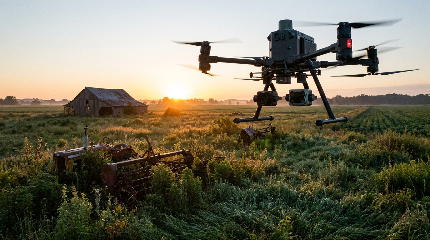
The mechanism behind these breakthroughs relies on multi-sensor fusion. Drones equipped with high-resolution optical, multispectral, and thermal infrared cameras fly over suspected hazardous areas. Because plastic and metal mines retain heat differently than surrounding soil, thermal cameras flown just before dawn can capture the distinct temperature anomalies of buried explosives.[10]
These massive datasets are then fed into region-based convolutional neural networks (R-CNNs). Studies from researchers at Binghamton University and the Center for International Stabilization and Recovery demonstrated that expanding training datasets with diverse environments—such as rubble, sand, and tall grass—improved the AI's ability to detect scatterable anti-personnel mines from 71.5% to nearly 92%.[6]
The HALO Trust, the world's largest humanitarian mine clearance charity, has aggressively adopted this workflow. In 2024 alone, the organization logged over 85,800 drone flight minutes in Ukraine, identifying more than 11,000 hazards. HALO integrates its drone imagery with satellite data from Planet Labs and processes it using Amazon Web Services' analytical AI tools.[2][8]
The HALO Trust, the world's largest humanitarian mine clearance charity, has aggressively adopted this workflow.
Counterintuitively, one of the most valuable applications of AI in demining is not finding mines, but proving their absence. In post-conflict zones, the fear of contamination can paralyze agriculture just as effectively as actual explosives. HALO uses AI and geospatial mapping to "cancel" suspected areas, proving to local communities that the land is safe to farm.[2]
This cancellation effect has dramatically reshaped the recovery landscape. Initial estimates suggested that 174,000 square kilometers of Ukraine—an area roughly the size of Florida—were contaminated. By utilizing AI and satellite data to precisely map and cancel safe zones, HALO has reduced that suspected area to roughly the size of Massachusetts, freeing up vast tracts of agricultural land.[2]

The technological upgrade is becoming a matter of survival for deminers. The UN Mine Action Service (UNMAS) reports that modern conflicts are increasingly utilizing "high-tech" landmines equipped with seismic, magnetic, or proximity sensors. These devices are designed to detonate when a human deminer or a traditional metal detector approaches.[1]
Drones bypass these terrestrial triggers entirely. By scanning from the air, they remove humans from the most dangerous phase of the operation—the initial survey and localization. Blackthorn's data indicates that AI drone systems reduced the accident rate to 0.5 incidents per 1,000 operations, a 90% decrease compared to manual surveys.[1][5]
The innovation extends beyond aerial drones. Ukraine's inland waterways, including the Dnipro River, suffer from severe contamination, with an estimated 13,500 square kilometers of aquatic territory requiring clearance. Zero-visibility water and strong currents make traditional diver-led demining exceptionally hazardous.[7]
To address this, the UN Development Programme (UNDP) and Ukraine's State Emergency Service (SESU) have deployed underwater Remotely Operated Vehicles (ROVs) developed by Deep Trekker. These aquatic drones use sonar and high-definition video to locate and identify submerged missile remnants and explosives before any human diver enters the water.[7]

Despite these profound advancements, experts caution against viewing AI as a silver bullet. The technology still faces significant limitations in complex environments. Dense vegetation, heavy rainfall, and deeply buried ordnance can obscure the visual and thermal signatures that machine learning models rely upon.[2][9]
"The problem with autonomy at the moment is that it struggles to cope with the depth at which the mine is laid," noted a HALO Trust representative. Demining remains an understandably cautious sector where a false negative can be fatal. Consequently, AI is currently treated as an operational aid rather than a definitive authority.[2]
The current consensus is a hybrid approach. AI and drones conduct the non-technical survey, rapidly shrinking a suspected minefield from the size of a football pitch to a specific six-yard box. Human sappers, remote-controlled mechanical rollers, or targeted charges are then deployed to neutralize the localized threat.[1]
As algorithmic learning evolves and sensor costs drop, the integration of robotics into humanitarian demining is expected to accelerate. By replacing the dangerous guesswork of manual probing with precise, data-driven mapping, these technologies are not just clearing explosives—they are rapidly restoring the economic and social foundations of war-torn communities.[9]
How we got here
World War II to 2010s
Humanitarian demining relies almost exclusively on manual prodding and handheld metal detectors, a slow and highly dangerous process.
2018–2021
Early field tests in regions like Chad demonstrate that thermal drone imagery can successfully identify the heat signatures of buried plastic and metal mines.
2024
The HALO Trust logs over 85,000 drone flight minutes in Ukraine, integrating satellite data and AWS AI tools to map and cancel massive tracts of suspected hazardous land.
Early 2025
Underwater ROVs are deployed in Ukraine's Dnipro river to safely locate submerged explosives in zero-visibility currents.
Late 2025
A landmark 18-month study presented at the GICHD Innovation Conference proves AI-augmented drone surveys increase demining productivity by over 800%.
Viewpoints in depth
Humanitarian Operators' View
Technology must serve the primary goal of civilian safety and verifiable land clearance.
For organizations like The HALO Trust and Norwegian People's Aid, AI is a means to an end, not a replacement for human judgment. Their primary metric is not just the number of mines found, but the amount of land verifiably returned to communities. They emphasize that while drones excel at 'non-technical surveys' and canceling suspected hazardous areas, the final clearance of a minefield still requires physical intervention. The sector remains inherently cautious, prioritizing 100% clearance rates over pure speed, meaning new technologies are rigorously tested before being integrated into standard operating procedures.
Technology Developers' View
Algorithmic advancements and multi-sensor fusion can solve the bottleneck of manual demining.
Software engineers and robotics firms view the traditional manual demining process as dangerously inefficient. By applying deep learning models like R-CNNs to massive datasets of aerial imagery, they argue that the industry can achieve exponential leaps in productivity. Developers focus on continuous model training, expanding datasets to include various terrains and weather conditions, and integrating thermal and multispectral sensors to detect anomalies that human eyes miss. Their data suggests that automating the survey phase is the single most effective way to reduce deminer casualties and lower the prohibitive costs of clearance.
What we don't know
- It remains unclear how quickly AI models can be adapted to detect deeply buried explosives or operate effectively in dense jungle environments.
- The long-term funding models for scaling these advanced technologies across all 60+ contaminated countries are still being developed.
Key terms
- Non-Technical Survey (NTS)
- The process of collecting and analyzing data about a suspected hazardous area without physically entering the minefield, increasingly done using drones and AI.
- Unexploded Ordnance (UXO)
- Explosive weapons, such as bombs, shells, and grenades, that did not explode when they were deployed and still pose a risk of detonation.
- Remotely Operated Vehicle (ROV)
- An unoccupied underwater robot connected to an operator via a tether, used to safely scan and identify explosives in rivers and coastal waters.
- Orthomosaic
- A detailed, accurate map created by stitching together numerous overlapping aerial photographs taken by a drone.
- Scatterable Mines
- Landmines that are dropped from aircraft or artillery over a wide area rather than being individually buried by hand, making them difficult to map manually.
Frequently asked
Can AI completely replace human deminers?
No. Currently, AI and drones are used for 'non-technical surveys' to map areas, locate surface anomalies, and prove certain lands are safe. Human sappers or remote-controlled machines are still required to physically excavate and neutralize the buried explosives.
How do drones detect buried landmines?
Drones use a combination of high-resolution optical, multispectral, and thermal cameras. Thermal imaging is particularly effective just before dawn, as plastic and metal mines retain heat differently than the surrounding soil, creating a visible temperature anomaly.
Why is 'canceling' land so important?
In post-conflict zones, the mere suspicion of landmines prevents civilians from farming or rebuilding. By using AI and satellite data to definitively prove an area is empty, demining groups can rapidly return vast tracts of land to the community without needing to physically sweep every inch.
Does AI work in all environments?
No. Machine learning models struggle in areas with dense vegetation, heavy rainfall, or where mines are buried deeply. The technology is most effective in open fields, deserts, and areas where explosives are laid on or near the surface.
Sources
Source coverage
10 outlets
4 viewpoints surfaced


[1]United NationsHumanitarian Demining Organizations
Mine action: New technologies paired with old to improve efficiency
Read on United Nations →[2]National Defense MagazineHumanitarian Demining Organizations
AI, Drones Revolutionizing Mine Clearance in Ukraine
Read on National Defense Magazine →[3]Geneva International Centre for Humanitarian DeminingHumanitarian Demining Organizations
GICHD Innovation Conference 2025
Read on Geneva International Centre for Humanitarian Demining →[4]Safe Pro GroupAI and Robotics Developers
Safe Pro AI and Norwegian People's Aid Present Findings on AI-Augmented Demining
Read on Safe Pro Group →[5]Blackthorn.aiAI and Robotics Developers
Landmine Detection using Deep Learning and Drones
Read on Blackthorn.ai →[6]ResearchGateAcademic Researchers
UAS and Deep Learning Algorithms for Scatterable Landmine Detection
Read on ResearchGate →[7]Deep TrekkerAI and Robotics Developers
Using ROVs for Submerged Demining in Ukraine
Read on Deep Trekker →[8]Center for International Stabilization and RecoveryHumanitarian Demining Organizations
Drones are transforming landmine detection in Ukraine
Read on Center for International Stabilization and Recovery →[9]Factlen Editorial TeamFactlen Analysis
Synthesis by Factlen editorial team
Read on Factlen Editorial Team →[10]EsriAI and Robotics Developers
Partnering on Mine Detection and Mapping
Read on Esri →
Every angle. Every day.
Get defense security stories with full source coverage and perspective breakdowns delivered to your inbox.