LiDAR Scans Reveal Vast Network of Ancient 'Garden Cities' Beneath the Amazon
Advanced laser mapping has uncovered evidence of massive, 2,500-year-old urban networks hidden beneath the Amazon canopy, fundamentally rewriting the history of the Americas.
By Factlen Editorial Team
- Archaeological Consensus
- Focuses on how LiDAR data fundamentally rewrites the history of pre-Columbian population density.
- Indigenous & Decolonial Scholars
- Critiques the 'lost city' trope, emphasizing continuity and prior local knowledge.
- Ecological & Climate Researchers
- Focuses on how ancient 'garden urbanism' offers sustainable models for modern land use.
What's not represented
- · Modern Indigenous communities living near the sites
- · Local government land-use policymakers
Why this matters
This technological breakthrough shatters the long-held myth that the Amazon was an untouched wilderness, proving instead that ancient Indigenous societies sustainably managed complex, large-scale urban environments. Understanding their methods of 'garden urbanism' and soil enrichment could provide vital blueprints for modern sustainable agriculture and rainforest conservation.
Key points
- LiDAR technology has revealed a massive 2,500-year-old network of interconnected cities in the Ecuadorian Amazon.
- Statistical models estimate that up to 24,000 ancient earthworks remain hidden beneath the Amazon canopy.
- These societies practiced 'garden urbanism,' integrating residential areas with extensive agriculture and managed forests.
- Ancient Amazonians engineered the soil to create highly fertile 'terra preta,' allowing for sustainable, long-term farming.
- Scholars warn against the 'lost city' narrative, noting it often erases decades of prior work by local researchers and Indigenous knowledge.
For centuries, the prevailing historical narrative painted the Amazon rainforest as a pristine, untouched wilderness—a "green desert" where poor soils and an impenetrable canopy could only support small, scattered, nomadic tribes. This assumption shaped not only the field of archaeology but also modern ecological conservation, operating on the deeply ingrained belief that the world's largest rainforest had existed in a state of nature entirely separate from large-scale human influence. Early European accounts from the 16th century, which described massive, densely populated cities stretching along the banks of the Amazon River, were long dismissed by modern scholars as colonial exaggerations or outright myths. Without stone pyramids or visible monuments to anchor their claims, archaeologists who argued for a more complex Amazonian history struggled to find definitive proof hidden beneath millions of square miles of dense vegetation.[3][4]
That long-held consensus is now collapsing entirely. A wave of recent archaeological breakthroughs, driven by the application of advanced remote-sensing technology, has provided definitive, undeniable evidence that the Amazon was home to vast, complex, and densely populated urban networks long before European contact. Rather than a pristine wilderness, the Amazon is increasingly understood as a heavily managed "cultural forest," engineered over millennia by sophisticated agrarian societies. This paradigm shift is forcing historians, ecologists, and anthropologists to completely rewrite the textbooks on pre-Columbian civilizations, elevating ancient Amazonian societies to a level of complexity and scale comparable to the Maya of Mesoamerica or the early urban centers of Europe.[1][2]
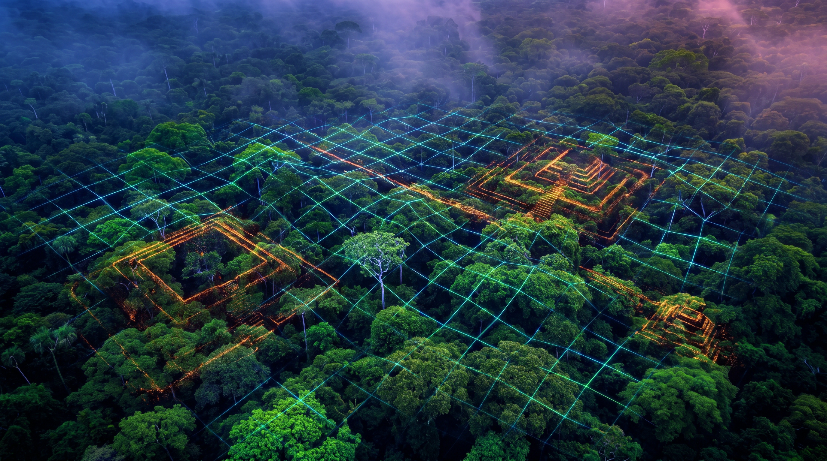
The primary catalyst for this archaeological revolution is LiDAR (Light Detection and Ranging). By mounting highly sensitive laser scanners on aircraft or drones, researchers can fire millions of light pulses per second down through the dense jungle canopy. While most of the lasers hit the trees, a fraction reach the forest floor and bounce back. Advanced computer algorithms then strip away the vegetation data, revealing the bare topography of the ground in unprecedented, high-resolution 3D detail. This technology allows researchers to accomplish in a few hours of flight time what would take decades of grueling, machete-wielding fieldwork on the ground, effectively peeling back the forest to expose the geometric scars of ancient human engineering.[4][7]
The most dramatic and concrete evidence of this hidden world recently emerged from the Upano Valley in the eastern foothills of the Ecuadorian Andes. A landmark study published in the journal Science detailed the discovery of a 2,500-year-old agrarian civilization that built a sprawling, highly organized network of interconnected cities. For decades, a small handful of archaeologists had painstakingly excavated mounds in the region, suspecting a larger settlement, but the sheer scale of the society remained obscured by the jungle. When LiDAR mapping was finally applied to the Upano Valley, the resulting images shocked the archaeological community, revealing an urban footprint that stretched across hundreds of square kilometers.[1][4]
Within a 300-square-kilometer survey area, researchers identified more than 6,000 rectangular earthen platforms and plaza structures. These were not isolated, temporary outposts, but a highly organized and permanent urban landscape. The platforms, which served as foundations for large timber and thatch buildings, were arranged in distinct geometric patterns around central plazas, indicating strict urban planning and civic administration. The sheer volume of earth moved to construct these mounds points to a highly structured society with a massive labor force, capable of executing complex, multi-generational public works projects.[1]

Perhaps the most astonishing feature of the Upano settlements is the complex, regional-scale network of wide, straight roads and canals that linked the urban centers. Some of these excavated causeways extended for tens of kilometers across the landscape, connecting major cities with smaller satellite towns and agricultural hinterlands. The roads were engineered with remarkable precision, cutting straight through the undulating terrain rather than following the natural contours of the land. This vast communication and transportation network demonstrates a level of regional integration, engineering prowess, and social organization that rivals the famous road systems of the ancient Maya or even the Roman Empire.[1][4]
This discovery represents the earliest and largest low-density agrarian urbanism ever documented in the Amazon basin. Extensive archaeological excavations and radiocarbon dating indicate that the construction and occupation of these monumental platforms and road networks began roughly around 500 BCE and flourished until between 300 and 600 CE. The civilization, primarily attributed to the Kilamope and later Upano cultures, thrived for over a millennium before eventually declining. The revelation that such a massive, interconnected society existed in the Amazon over two thousand years ago fundamentally shatters the timeline of human development in South America.[1]
This discovery represents the earliest and largest low-density agrarian urbanism ever documented in the Amazon basin.
But the monumental discoveries in the Upano Valley are just a fraction of the broader Amazonian story. A separate, basin-wide analysis, also published in Science, utilized advanced statistical modeling to estimate the true scale of pre-Columbian settlement across the entire 6.7-million-square-kilometer Amazon rainforest. Because LiDAR surveys are expensive and have currently mapped less than 0.1 percent of the total Amazon basin, researchers needed a way to predict what lies in the vast, unsurveyed expanses. By combining existing LiDAR data with environmental variables like soil type, precipitation, and distance to water, the team generated a predictive map of ancient human occupation.[2][6]
The results of this statistical modeling are staggering. The researchers predict that between 10,272 and 23,648 large-scale archaeological sites—primarily geometric earthworks, geoglyphs, and terraced settlements—remain entirely hidden beneath the dense forest canopy. These estimates suggest that the Amazon was not just home to a few isolated pockets of civilization, but was a densely populated continent teeming with interconnected societies. The model indicates that the highest concentration of these undiscovered earthworks is likely located in the southwestern Amazon, a region that is now recognized as a major hotspot for ancient earth-building cultures.[2][6]

To put this into perspective, the thousands of earthworks and geoglyphs that have already been documented by archaeologists over the past several decades account for a mere 4 to 9 percent of the estimated total. This means that over 90 percent of the Amazon's ancient architectural heritage is still waiting to be uncovered. The realization that tens of thousands of ancient settlements are sitting just beneath the trees has ignited a modern gold rush in archaeology, with international teams racing to deploy LiDAR across different sectors of the basin before modern deforestation and land development can destroy the sites.[2]
The societies that built these vast networks practiced a unique form of settlement that researchers now refer to as "garden urbanism." Unlike the densely packed, stone-paved cities of Europe or Mesoamerica, which often required clear-cutting forests and strictly separating nature from human habitation, Amazonian cities were woven directly into the living landscape. They integrated residential platforms and civic plazas with extensive agricultural terraces, drained fields, and managed forests. This low-density, sprawling approach to urban design allowed massive populations to live in harmony with the rainforest ecosystem, creating a sustainable model of urbanism that lasted for centuries.[1][3]
Ecological data strongly supports the deep and lasting human footprint of this garden urbanism. Researchers have found significant correlations between the locations of ancient earthworks and the hyper-abundance of specific domesticated tree species. Across the Amazon, areas surrounding ancient settlements show unusually high concentrations of useful plants, such as the Brazil nut, cacao, and various palm species. These are not natural distributions; they are the living legacy of ancient indigenous arboriculture, proving that pre-Columbian societies actively managed and engineered their environment to cultivate vast "forest orchards" that provided a reliable and abundant food supply.[2][6]

In addition to managing the canopy, these ancient societies engineered the very soil beneath their feet. Over generations of composting, mulching, and controlled burning, they transformed the naturally nutrient-poor Amazonian dirt into terra preta, or Amazonian dark earth. This highly fertile, carbon-rich soil allowed for intensive, continuous agriculture without the need to constantly clear new land. Today, the presence of terra preta is one of the most reliable indicators of ancient human settlement, and its enduring fertility serves as a testament to the sustainable, regenerative agricultural practices of the Amazon's original inhabitants.[3][6]
However, the framing of these groundbreaking discoveries has sparked intense debate within the academic community. As global media outlets have eagerly proclaimed the discovery of "lost cities" and dubbed the finds the "Rome of the rainforest," some scholars and indigenous advocates warn that this sensationalized narrative is highly problematic. They argue that the "lost city" trope is rooted in colonial mentalities, painting the Amazon as an empty frontier waiting to be "discovered" by Western scientists equipped with high-tech lasers, while ignoring the people who have lived there continuously for millennia.[5]
Critics point out that framing these settlements as "lost" actively erases decades of prior groundwork by local South American archaeologists, as well as the oral histories and traditional knowledge of contemporary Indigenous communities. Many of the sites that are now making global headlines were not entirely unknown; they had been identified, surveyed, and excavated by local researchers long before LiDAR was ever flown over the canopy. The technology did not conjure these cities out of thin air; rather, it provided the sweeping, high-resolution visual synthesis required to prove their vast interconnectedness to a skeptical Western academic establishment.[5]

This debate highlights a crucial shift in how archaeology must be conducted moving forward. Decolonial scholars emphasize that the story of the Amazon's ancient cities is not just about lasers and statistical models, but about recognizing the continuous legacy of Indigenous land management. By acknowledging that these societies were never truly "lost" to the people who descended from them, the scientific community can move toward a more inclusive and accurate understanding of history—one that respects both the technological triumphs of modern remote sensing and the deep, enduring knowledge of the Amazon's original stewards.[5]
Ultimately, the LiDAR revolution is forcing a profound and necessary rewrite of human history in the Americas. The Amazon was never an untouched, empty wilderness; it was a heavily managed, brilliantly engineered landscape that supported millions of people in sustainable, low-density metropolises. As thousands more earthworks are inevitably mapped in the coming years, the focus will shift from merely finding these ancient cities to learning from them. In an era defined by climate change and ecological crisis, the ancient Amazonian blueprint of "garden urbanism" and regenerative agriculture may offer vital lessons for how modern societies can live sustainably within fragile ecosystems.[3][4][5]
How we got here
500 BCE
Construction begins on the massive earthen platforms and road networks in the Upano Valley of modern-day Ecuador.
1542 CE
Spanish explorer Francisco de Orellana reports seeing massive, densely populated cities along the Amazon River—accounts long dismissed as myths.
1978
Ecuadorian and Argentinian archaeologists first identify preliminary evidence of large settlements in the Upano Valley.
Oct 2023
A basin-wide statistical model published in Science estimates that up to 24,000 ancient earthworks remain hidden across the Amazon.
Jan 2024
A landmark LiDAR study maps the full 300-square-kilometer extent of the Upano Valley's 2,500-year-old 'garden cities.'
Viewpoints in depth
Archaeological Consensus
Mainstream researchers focused on how LiDAR data fundamentally rewrites the history of pre-Columbian population density.
This camp emphasizes the quantitative data provided by LiDAR and statistical modeling. They argue that the sheer volume of earthworks, causeways, and agricultural terraces proves the Amazon supported millions of people in complex, interconnected societies. For these scientists, the primary takeaway is the technological triumph of remote sensing in proving what was previously only suspected through scattered ground excavations.
Indigenous & Decolonial Scholars
Academics and advocates who critique the sensationalized 'discovery' narrative of Western media.
This perspective argues that framing these settlements as 'lost cities' is a colonial trope that erases both Indigenous oral histories and the decades of foundational fieldwork conducted by South American archaeologists. They point out that many of these sites were known to locals and researchers since the 1970s; LiDAR simply provided the high-resolution mapping required to satisfy Western academic standards. They advocate for research that centers Indigenous land rights and continuity.
Ecological & Climate Researchers
Scientists studying how ancient Amazonians sustainably managed the rainforest environment.
This camp focuses on the concept of 'garden urbanism' and the hyper-abundance of domesticated tree species near ancient settlements. They argue that pre-Columbian societies did not clear-cut the forest to build stone cities, but rather engineered the ecosystem to enhance biodiversity and soil fertility (such as creating terra preta). They view these ancient practices as vital blueprints for modern sustainable land use and conservation in the Amazon.
What we don't know
- The exact population size of these ancient Amazonian cities at their peak.
- The specific political and social structures that governed the vast regional road networks.
- The precise combination of factors (disease, climate, conflict) that led to the eventual abandonment of these specific urban centers.
Key terms
- LiDAR
- A remote sensing method that uses pulsed lasers to measure variable distances to the Earth, capable of penetrating dense forest canopies to reveal ground topography.
- Earthworks
- Artificial changes in land level, typically made from soil and unworked stone, used in antiquity for foundations, defensive walls, or agricultural terraces.
- Garden Urbanism
- A model of city planning where residential areas are deeply integrated with agricultural spaces, forests, and water management systems, resulting in a low-density but expansive urban footprint.
- Terra Preta
- Highly fertile, dark anthropogenic soil found in the Amazon Basin, created by ancient human communities through the addition of charcoal, bone, and compost.
- Pre-Columbian
- The era of history in the Americas before the arrival of Christopher Columbus and European colonizers in 1492.
Frequently asked
What is LiDAR and how does it work?
LiDAR (Light Detection and Ranging) uses laser pulses fired from an aircraft to measure distances to the ground. By filtering out the laser returns that hit trees, computers can generate a highly accurate 3D map of the bare forest floor beneath the canopy.
Were these cities built of stone like the Maya or Inca?
No. Amazonian civilizations primarily built with earth and timber. They constructed massive earthen platforms, plazas, and causeways, which is why their ruins appear as geometric mounds and trenches rather than stone pyramids.
Why were these cities abandoned?
While the exact causes vary by region, many of these societies were decimated by diseases introduced by European colonizers in the 16th century, leading to massive population collapse and the forest reclaiming the urban landscapes.
Does this mean the Amazon isn't a natural wilderness?
Yes, to a large extent. Researchers now consider much of the Amazon to be a "cultural forest," heavily managed and engineered by Indigenous peoples over thousands of years to cultivate useful tree species and enrich the soil.
Sources
Source coverage
7 outlets
3 viewpoints surfaced


[1]ScienceArchaeological Consensus
Two thousand years of garden urbanism in the Upper Amazon
Read on Science →More than 10,000 pre-Columbian earthworks are still hidden throughout Amazonia
Read on Science →[3]The GuardianEcological & Climate Researchers
Lost cities of the Amazon: how science is revealing ancient garden towns hidden in the rainforest
Read on The Guardian →[4]BBC Science FocusArchaeological Consensus
The hidden ancient mega-cities of the Amazon are finally revealing their secrets
Read on BBC Science Focus →[5]The Jerusalem PostIndigenous & Decolonial Scholars
LiDAR-found 'Lost Cities' May Never Have Been Lost at All, Scholars Warn
Read on The Jerusalem Post →[6]Utrecht UniversityArchaeological Consensus
Aerial 3D scans reveal hidden structures on forest floors
Read on Utrecht University →[7]Ahead of the HerdArchaeological Consensus
Lidar Scans Reveal Many Lost Cities, Thousands of Earthworks in the Amazon
Read on Ahead of the Herd →

Every angle. Every day.
Get science stories with full source coverage and perspective breakdowns delivered to your inbox.