LiDAR Scans Reveal Massive Ancient Urban Networks Hidden Beneath the Amazon
Airborne laser mapping has uncovered sprawling, 2,500-year-old cities in the Amazon rainforest, overturning the myth that the region was an untouched wilderness. The discoveries reveal a sophisticated model of low-density urbanism featuring towering earthen pyramids, engineered roads, and massive water-management systems.
By Factlen Editorial Team
- Archaeological Researchers
- Focused on rewriting the timeline of complex societies and documenting low-density urbanism.
- Indigenous Rights Advocates
- Focused on using LiDAR data to prove historic land tenure and protect the Amazon from commercial interests.
- Environmental Scientists
- Focused on how ancient peoples managed the forest sustainably without destroying it.
- Technological Innovators
- Focused on the capabilities of aerial scanning to non-destructively uncover the past.
What's not represented
- · Commercial agricultural developers operating in the Amazon
- · Modern urban planners analyzing tropical city design
Why this matters
These discoveries fundamentally rewrite human history, proving that one of the Earth's most vital ecosystems was sustainably managed by massive populations for millennia. For modern Indigenous groups, this hard data provides crucial legal evidence of historic land tenure to protect the forest from commercial exploitation.
Key points
- LiDAR technology has revealed massive, 2,500-year-old urban networks hidden beneath the Amazon canopy.
- The Upano Valley in Ecuador features over 6,000 earthen platforms connected by 15-mile engineered roads.
- Bolivia's Casarabe culture built 22-meter-tall earthen pyramids and extensive water-management systems.
- These discoveries prove the Amazon was not an untouched wilderness, but a heavily managed landscape.
- The settlements represent 'low-density urbanism,' integrating human habitation sustainably with the forest.
The foundational myth of the Amazon as an untouched "green desert"—a landscape too nutrient-poor to support complex civilization—has collapsed. Over the past decade, a wave of primary archaeological evidence has definitively proven that the rainforest was home to massive, interconnected urban centers.[5][6]
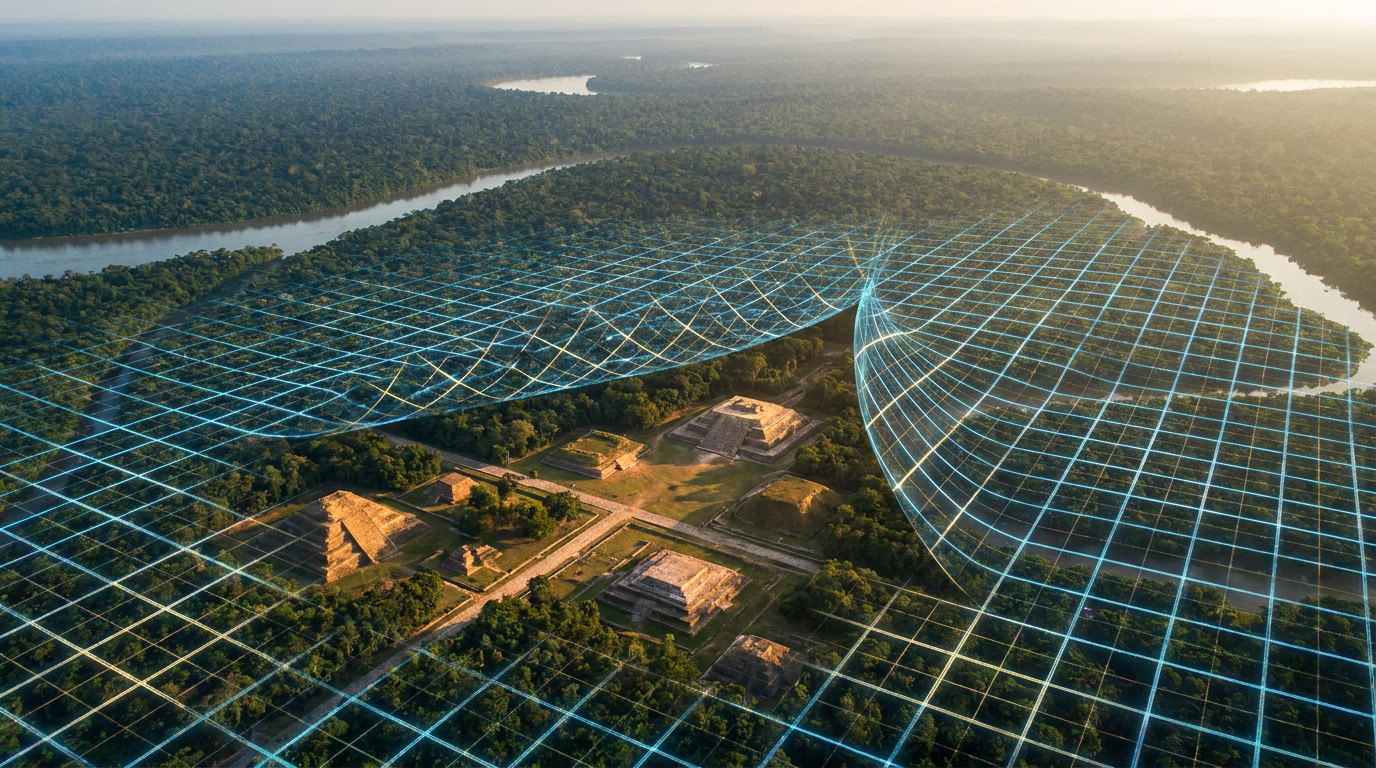
The primary mechanism driving this breakthrough is LiDAR (Light Detection and Ranging). By mounting laser scanners on aircraft, researchers fire millions of pulses per second at the forest canopy, allowing them to survey vast tracts of impenetrable jungle without lifting a single shovel.[4][8]
While most pulses reflect off the leaves, a fraction reach the forest floor. By measuring the return time, specialized software strips away the vegetation to generate a "bare-earth" 3D model. The evidence is irrefutable: the scans reveal geometric earthworks, perfectly straight roads, and towering pyramids that cannot be formed by natural processes.[4][7]

The strongest evidence for early Amazonian urbanism comes from the Upano Valley in eastern Ecuador. In a peer-reviewed paper published in Science, researchers detailed a 2,500-year-old monumental urban system that forces a rewrite of regional history and rivals the complexity of the Maya.[1][7]
The Science study maps over 6,000 earthen platforms arranged around central plazas. Ground excavations confirm these platforms served as residential foundations and ceremonial centers for a highly organized agrarian society that flourished from roughly 500 BCE to 600 CE.[1][5]
The LiDAR data provides hard evidence of advanced infrastructure. The Upano settlements were linked by a sophisticated web of engineered roads, some measuring up to 35 meters wide and stretching for 15 miles in perfectly straight lines across the undulating terrain.[1][8]
A second major pillar of evidence comes from the Llanos de Moxos region of Bolivia, detailing the Casarabe culture (AD 500–1400). A watershed study published in Nature mapped the staggering scale of this society's earth-moving capabilities across the flooded savannas.[2][3]

A second major pillar of evidence comes from the Llanos de Moxos region of Bolivia, detailing the Casarabe culture (AD 500–1400).
Because stone is scarce in the Amazon basin, the Casarabe built entirely with earth. The Nature paper documents conical pyramids reaching 22 meters (72 feet) in height, alongside massive U-shaped ceremonial structures built atop stepped platforms.[2][5]
The mapped Casarabe area spans approximately 4,500 square kilometers. The primary settlements, such as the 315-hectare site of Cotoca, were surrounded by concentric polygonal banks and defensive moats, serving as central nodes for a four-tiered settlement hierarchy.[2]
The evidence for environmental engineering is equally robust. To survive in a landscape defined by extreme seasonal flooding, the Casarabe constructed massive water-management infrastructure, including extensive canals and reservoirs that transformed the flooded savannas into productive agricultural hubs.[2][5]
Archaeologists classify these networks as "low-density urbanism." Unlike the densely packed, vertically stacked cities of medieval Europe or the Maya core, these Amazonian centers were spread out, integrating the natural environment directly into the urban footprint.[2][3]

Residential areas and ceremonial centers were interspersed with agricultural terraces, managed forests, and water systems. The evidence suggests a model of urban life that did not require the eradication of the surrounding ecosystem, but rather its careful, sustainable management.[3][5]
While the topographical evidence provided by LiDAR is absolute, certain variables remain uncertain. Population estimates rely on platform counts and assumptions about household size, leaving exact demographic numbers a subject of ongoing debate among anthropologists.[1][2]
Furthermore, the exact causes of these civilizations' eventual decline remain unproven. While the Casarabe culture faded around 1400 CE, researchers hypothesize that a combination of climate shifts, changing river courses, and the later arrival of European diseases played a role, though physical evidence for the collapse is still being excavated.[3]

For modern Indigenous communities, these peer-reviewed maps offer more than academic intrigue. Initiatives like the "Amazonia Revelada" project use this hard data to prove their ancestors' deep, historic presence on the land, providing crucial legal evidence to ward off modern commercial logging and farming interests.[3][6]
The sheer volume of recent discoveries indicates that the current maps represent only a fraction of what exists. As LiDAR surveys expand across the basin, the scientific consensus is clear: the Amazon was never an empty wilderness, but a carefully curated landscape shaped by millions of hands over millennia.[4][5]
How we got here
500 BCE
The Upano Valley civilization begins constructing extensive earthen platforms and road networks in modern-day Ecuador.
500 CE
The Casarabe culture emerges in Bolivia, engineering massive pyramids and water-management reservoirs.
1400 CE
The Casarabe culture begins to decline, leaving their massive earthworks to be reclaimed by the rainforest.
May 2022
A landmark Nature study publishes LiDAR data revealing the staggering scale of Casarabe low-density urbanism.
January 2024
Researchers publish findings in Science detailing the 2,500-year-old monumental urban system in the Upano Valley.
Viewpoints in depth
Archaeological Consensus
Researchers view the LiDAR data as definitive proof that the Amazon supported complex, large-scale societies.
For decades, the prevailing academic theory held that the Amazon's nutrient-poor soils could only support small, nomadic hunter-gatherer tribes. The sheer volume of earth moved to create the Casarabe and Upano settlements has shattered this paradigm. Anthropologists now recognize that ancient Amazonians utilized 'terra preta' (anthropogenic dark earth) and massive water-management systems to overcome environmental limitations, sustaining populations in the tens of thousands.
Indigenous Land Defenders
Modern Indigenous groups use archaeological data to secure legal land rights.
The discovery of these ancient cities is not merely a historical curiosity; it is a modern legal tool. Initiatives like 'Amazonia Revelada' partner with archaeologists to map ancestral territories. By proving that Indigenous peoples have continuously occupied and managed these landscapes for millennia, local communities can present hard evidence in court to ward off encroachment from commercial logging, mining, and industrial agriculture.
Ecological Planners
Environmental scientists study these ancient cities for lessons in sustainable urbanism.
Unlike modern cities that pave over ecosystems, the Amazonian model of 'low-density urbanism' integrated human habitation with the forest. By dispersing residential areas among managed orchards, agricultural terraces, and reservoirs, these ancient societies thrived without destroying the rainforest's biodiversity. Ecologists argue that studying how these civilizations balanced urban growth with ecological preservation could inform modern sustainable development in tropical regions.
What we don't know
- The exact population sizes of these ancient cities, as estimates rely heavily on platform counts rather than comprehensive physical excavations.
- The precise reasons for the eventual abandonment of these massive urban networks, though climate shifts and European diseases are suspected.
- How many more ancient cities remain undiscovered, as LiDAR has only mapped a fraction of the vast Amazon basin.
Key terms
- LiDAR
- Light Detection and Ranging, a remote sensing method that uses pulsed lasers from aircraft to map the bare-earth topography beneath dense vegetation.
- Low-density urbanism
- A city layout where residential and ceremonial areas are spread out and interspersed with agricultural land, rather than densely packed together.
- Casarabe culture
- A pre-Hispanic civilization that flourished in the Llanos de Moxos region of Bolivia, known for building massive earthen pyramids.
- Upano Valley
- A region in eastern Ecuador where LiDAR revealed a 2,500-year-old network of interconnected urban settlements and engineered roads.
Frequently asked
What is LiDAR and how does it find ruins?
LiDAR uses aircraft to fire millions of laser pulses at the ground. By measuring the return time, computers filter out the forest canopy to reveal the bare earth and any human-made structures beneath.
Did these Amazonian cities have stone pyramids?
No. Because stone is scarce in the Amazon basin, these civilizations engineered massive monumental architecture entirely out of earth.
Why were these cities abandoned?
The exact reasons remain unknown. Archaeologists suspect a combination of climate shifts, changing river courses, and the eventual arrival of European diseases.
Sources
Source coverage
8 outlets
4 viewpoints surfaced


[1]ScienceArchaeological Researchers
A 2,500-year-old monumental urban system in the Ecuadorian Amazon
Read on Science →[2]NatureArchaeological Researchers
Lidar reveals pre-Hispanic low-density urbanism in the Bolivian Amazon
Read on Nature →[3]The ConversationIndigenous Rights Advocates
Rediscovering a 'lost civilization' in the Amazon
Read on The Conversation →[4]The DebriefTechnological Innovators
LiDAR: Unearthing Lost Worlds Hidden from Time
Read on The Debrief →[5]Economic TimesEnvironmental Scientists
A Lost Civilization Under the Rainforest? LiDAR Is Rewriting Amazon History
Read on Economic Times →[6]Colombia OneIndigenous Rights Advocates
LiDAR Reveals Ancient Cities Hidden in the Amazon
Read on Colombia One →[7]CBC NewsTechnological Innovators
LiDAR leads the way to ancient Amazonian cities
Read on CBC News →[8]Popular ArcheologyArchaeological Researchers
Technology Reshaping Archaeological Discovery
Read on Popular Archeology →
Every angle. Every day.
Get science stories with full source coverage and perspective breakdowns delivered to your inbox.