Is Climate Change Supercharging El Niño? The Evidence Behind the 2026 Forecast
As a potentially record-breaking El Niño begins, scientists are debating whether global warming is altering the climate pattern itself or simply raising the baseline temperature it operates on.
By Factlen Editorial Team
- Climate Attribution Scientists
- This camp argues that the primary driver of extreme weather is the higher baseline temperature of the planet, not a change in El Niño itself.
- Meteorological Forecasters
- This camp focuses on the oceanic and atmospheric mechanics, warning of a potentially historic temperature spike based on sea-surface data.
- Agricultural & Economic Analysts
- This camp focuses on the downstream consequences for global food security, crop yields, and commodity markets.
What's not represented
- · Vulnerable Coastal Communities
- · Smallholder Farmers in the Global South
Why this matters
The distinction between a supercharged El Niño and a hotter baseline dictates how governments and agricultural markets prepare for extreme weather. A more volatile ENSO cycle means less predictable crop yields, more severe floods, and a higher likelihood of breaching the 1.5°C global warming threshold.
Key points
- NOAA and the WMO have officially confirmed the arrival of an El Niño event, with a 63% chance of it becoming 'very strong' by late 2026.
- Scientists are debating whether climate change is directly making the El Niño mechanism more volatile, or simply raising the baseline temperature it operates on.
- The combination of El Niño and human-caused global warming is expected to push 2026 or 2027 to become the warmest year on record.
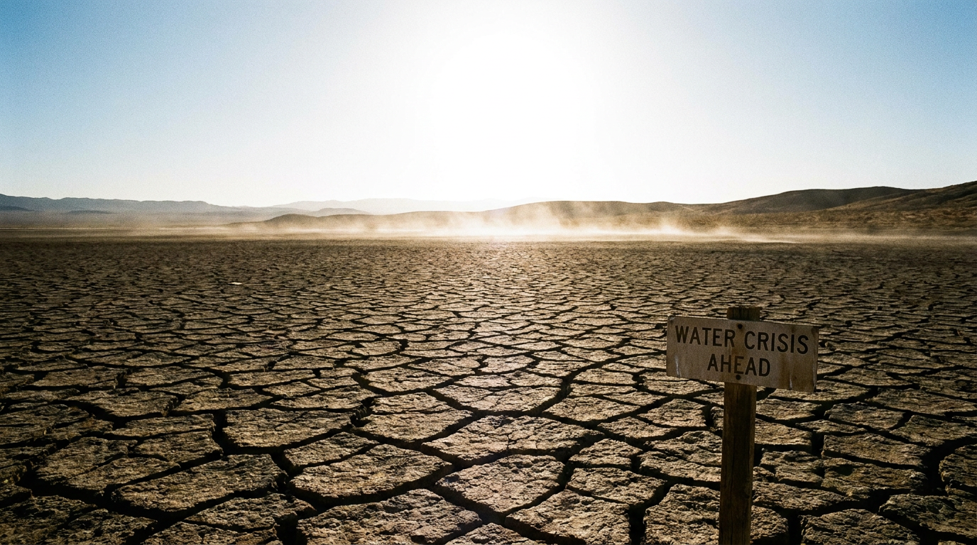
- The shifting weather patterns are projected to cause severe droughts in Australia and Southeast Asia, threatening global crop yields and food prices.
The tropical Pacific Ocean is heating up rapidly. In June 2026, the National Oceanic and Atmospheric Administration (NOAA) and the World Meteorological Organization (WMO) officially declared the arrival of an El Niño event. This powerful climate pattern, characterized by unusually warm sea-surface temperatures near the equator, has historically triggered a cascade of global weather disruptions, amplifying extremes from heatwaves and droughts to torrential rainfall.[2][3][4]
Coming off a streak of record-breaking global temperatures, the arrival of this phenomenon has sparked a vigorous debate among researchers. The central question is whether human-caused climate change is actively supercharging the El Niño mechanism itself, or simply raising the baseline temperature upon which it operates. The distinction carries profound implications for how scientists model future climate risks and how governments prepare for the ensuing fallout.[1]
To evaluate the evidence, it is necessary to understand the mechanics of the El Niño-Southern Oscillation (ENSO). Under normal conditions, strong trade winds blow west across the tropical Pacific, pushing warm surface water toward Asia and Australia. This allows cold, nutrient-rich water from the deep ocean to upwell along the western coast of South America, regulating regional climates.[4]
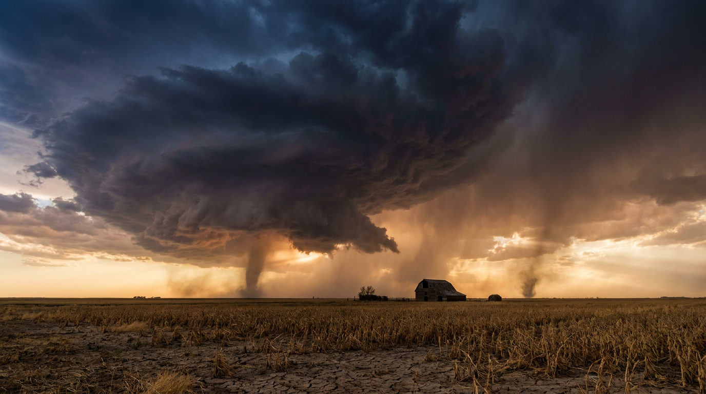
During an El Niño event, these trade winds weaken or even reverse. The accumulated warm water sloshes back eastward toward the Americas. This massive redistribution of oceanic heat reshapes the Walker Circulation—the east-to-west atmospheric air flow—altering jet streams and storm tracks worldwide.[2][4]

The current observational evidence for a strong event is robust. Satellite measurements from the European Space Agency show a sharp surge in sea-surface temperatures across the equatorial Pacific. The Niño-3.4 index, a key metric for monitoring the region, recently hit +0.7°C above average, prompting NOAA to issue an official El Niño Advisory.[2][4]
The trajectory of this warming is alarming forecasters. NOAA currently estimates a 63 percent probability that this El Niño will reach "very strong" status by the November-January period. Such an event, historically dubbed a "Super El Niño" in the media, would rank among the largest episodes in the historical record dating back to 1950.[2]
The first major claim in the scientific debate is that climate change is raising the baseline, not altering the mechanism. The most widely accepted consensus, championed by groups like World Weather Attribution, argues that El Niño is acting normally, but on a dramatically altered planet. Climate scientist Friederike Otto notes that El Niño is a natural phenomenon that comes and goes, but its impacts are now amplified by the nearly 1.5°C of global warming already experienced.[6]
The first major claim in the scientific debate is that climate change is raising the baseline, not altering the mechanism.
The evidence for this baseline effect is overwhelming. Because the oceans have absorbed vast amounts of anthropogenic heat, any natural warming phase starts from a higher floor. Carbon Brief estimates that the combination of this baseline warming and the new El Niño could push 2026 or 2027 to become the warmest year on human record, potentially breaching the 1.5°C threshold set by the Paris Agreement.[3][7]

The second, more contested claim is that climate change is directly increasing ENSO volatility. This theory suggests that global warming is actively injecting energy into the ENSO cycle, making the swings between El Niño and La Niña more extreme. Some climate models indicate that a warmer atmosphere holds more moisture and alters wind patterns in ways that amplify the ocean-atmosphere feedback loop.[1][8]
The uncertainty surrounding this second claim remains high. The WMO and other meteorological bodies caution that attributing the specific mechanics of the trade-wind collapse to anthropogenic warming is a complex challenge. The natural noise of the climate system makes it difficult to definitively prove that the ENSO engine itself is running hotter, rather than just operating in a hotter room.[1][3][8]
Regardless of the exact mechanism, the downstream impacts are highly predictable and severe. A strong El Niño typically suppresses hurricane activity in the Atlantic Basin while supercharging it in the Pacific. It brings heavy rainfall to the southern United States and South America, while triggering severe droughts in Australia, Southeast Asia, and southern Africa.[2][3][5]

These shifting weather patterns will put global food security under immense pressure. The Copernicus Climate Change Service and the Joint Research Centre warn that crop productivity in Sub-Saharan Africa, India, and Australia is expected to decline. This disruption is predicted to drive up the global prices of agricultural staples, particularly durum wheat and maize.[5]
Forecasting the exact peak of this event still carries a margin of error. Meteorologists often cite the "spring predictability barrier," a period where models struggle to accurately project late-year conditions. Though forecasters are moving past this barrier for 2026, the exact magnitude of the winter peak and its localized impacts remain probabilistic rather than certain.[2][3]

Ultimately, the distinction between a "supercharged El Niño" and a "normal El Niño on a supercharged planet" may be purely academic for the communities facing its impacts. The convergence of this natural cycle with record-high greenhouse gas levels guarantees a period of extreme climate volatility over the next 18 months.[3][8]
The arrival of a potentially record-breaking El Niño serves as a stress test for global resilience. Whether the mechanism is altered or the baseline is simply higher, the empirical data points to an incoming wave of extreme heat, disrupted agriculture, and severe weather that will demand immediate adaptation from governments and markets alike.[5][8]
How we got here
April 2026
Carbon Brief reports the first three months of 2026 were the fourth warmest on record, despite lingering La Niña conditions.
May 2026
Sea-surface temperatures in the central-eastern Equatorial Pacific rapidly approach El Niño thresholds.
June 11, 2026
NOAA officially issues an El Niño Advisory, confirming the pattern has developed.
June 15, 2026
Copernicus Climate Change Service warns of severe downstream impacts on global food security.
Late 2026
El Niño is projected to peak, with a 63% chance of reaching 'very strong' status during the winter.
Viewpoints in depth
Climate Attribution Scientists
This camp argues that the primary driver of extreme weather is the higher baseline temperature of the planet, not a change in El Niño itself.
Researchers focused on climate attribution emphasize that while El Niño is a powerful natural phenomenon, it is currently acting upon an ocean that has absorbed decades of anthropogenic heat. They argue that the ENSO cycle itself may not be fundamentally altered, but because it is starting from a much higher temperature floor, the resulting heatwaves, droughts, and floods are mathematically guaranteed to be more severe. Their models suggest that human-induced global warming plays a far larger role in 2026's extreme weather than the El Niño pattern alone.
Meteorological Forecasters
This camp focuses on the oceanic and atmospheric mechanics, warning of a potentially historic temperature spike.
Agencies like NOAA and the WMO are primarily concerned with the physical mechanics of the developing event. By tracking sea-surface temperature anomalies and the breakdown of the Walker Circulation, they project a high probability of a 'very strong' El Niño by late 2026. While they acknowledge the warmer baseline, their immediate focus is on the rapid eastward shift of warm Pacific water and the resulting disruption to global jet streams, which will dictate the specific locations of storms and droughts over the next 12 months.
Agricultural & Economic Analysts
This camp focuses on the downstream consequences for global food security and commodity markets.
For researchers at the Joint Research Centre and global commodities analysts, the exact meteorological mechanism is secondary to the material impacts on the ground. They are tracking how the forecasted shifts in rainfall will affect crop yields in highly vulnerable regions like Sub-Saharan Africa, India, and Australia. Their models indicate that the 2026-2027 El Niño could severely depress the production of staples like maize and durum wheat, triggering price spikes and exacerbating food insecurity in import-dependent nations.
What we don't know
- Whether climate change is permanently altering the frequency and intensity of the ENSO cycle, or if the current volatility is within natural historical bounds.
- The exact peak temperature anomaly this El Niño will reach during the Northern Hemisphere winter.
- How the combination of a strong El Niño and record-high ocean temperatures outside the Pacific will interact to affect regional weather systems.
Key terms
- El Niño-Southern Oscillation (ENSO)
- A recurring climate pattern involving changes in the temperature of waters in the central and eastern tropical Pacific Ocean.
- Walker Circulation
- A massive east-to-west atmospheric air flow over the tropical Pacific Ocean, driven by temperature and pressure differences.
- Niño-3.4 Index
- A specific region in the equatorial Pacific Ocean used by meteorologists to monitor sea-surface temperatures and classify El Niño events.
- Spring Predictability Barrier
- A period during the Northern Hemisphere spring when forecasting the development of ENSO events is notoriously difficult and less accurate.
Frequently asked
What is a 'Super El Niño'?
It is an informal media term for a 'very strong' El Niño event where sea-surface temperatures in the central Pacific reach at least 2.0°C above average.
How does El Niño affect global temperatures?
El Niño releases massive amounts of heat from the Pacific Ocean into the atmosphere, temporarily boosting global average temperatures.
Will this El Niño cause more hurricanes?
It typically suppresses hurricane formation in the Atlantic Basin due to increased wind shear, but it supercharges hurricane activity in the central and eastern Pacific.
How long does an El Niño event usually last?
Events typically occur every two to seven years and usually last around nine to twelve months, peaking during the Northern Hemisphere winter.
Sources
Source coverage
8 outlets
3 viewpoints surfaced


[1]The New York TimesAgricultural & Economic Analysts
Is Climate Change Supercharging El Niño?
Read on The New York Times →[2]NOAAMeteorological Forecasters
El Niño Advisory: Conditions are present and expected to strengthen
Read on NOAA →[3]World Meteorological OrganizationMeteorological Forecasters
WMO Update: El Niño conditions are developing
Read on World Meteorological Organization →[4]European Space AgencyMeteorological Forecasters
Satellite measurements show sharp surge in sea-surface temperatures
Read on European Space Agency →[5]Copernicus Climate Change ServiceAgricultural & Economic Analysts
El Niño evolution and its effects on global climate
Read on Copernicus Climate Change Service →[6]EosClimate Attribution Scientists
El Niño Could Lead to Unprecedented Year of Global Fire
Read on Eos →[7]Carbon BriefClimate Attribution Scientists
State of the climate: 2026 likely to be second-warmest year on record
Read on Carbon Brief →[8]Factlen Editorial Team
Synthesis by Factlen editorial team
Read on Factlen Editorial Team →

More in science
See all 5 stories →

Every angle. Every day.
Get science stories with full source coverage and perspective breakdowns delivered to your inbox.